Location
Latitude: |
41-30-56.1300N (41.515592) |
Longitude: |
075-15-05.6150W (-75.25156) |
Elevation: |
1357.0 feet MSL (414 m MSL) |
Magnetic Variation: |
12.1 W (as of April 2024 from WMM2020 model) |
Time Zone: |
UTC -5.0 (Standard Time) UTC -4.0 (Daylight Savings Time) |
From City: |
03 N.M. S of Honesdale, Pennsylvania |
Found On: |
New York Chart |
FAA Region: |
AEA |
Contacts
Manager: |
Privately owned: |
| RICHARD QUITONI 30 BOMBER LANE HONESDALE, PA 18431 570-253-5833 |
EARLYNN AVIATION 30 BOMBER LANE HONESDALE, PA 18431 570-253-5833 |
Operations
Airport Status: |
Operational |
Facility Use: |
Public |
Type: |
Airport |
Activation Date: |
03/1965 |
Control tower: |
No |
Attendance (Months/Days/Hours): |
Months/Days/Hours ALL/ALL/0900-1700 |
Boundary ARTCC: |
ZNY (New York) |
Responsible ARTCC: |
ZNY (New York) |
Lighting Schedule: |
SS-SR |
Segmented Circle Indicator: |
No |
Traffic Pattern Altitude (MSL): |
2357 feet (718 m) |
NOTAMs Facility: |
IPT |
NOTAM-D Service: |
Yes |
International Airport of Entry: |
No |
Customs Landing Rights: |
No |
Military Landing Rights: |
No |
Civil/Military Joint Use: |
No |
Based Aircraft
| Single Engine: | 49 |
| GA Helicopters: | 1 |
| Ultralights: | 5 |
Annual Operations (as of 10/05/2022)
| Total Operations: | 23010 | |
| GA Local: | 15000 | 65.2% |
| GA Itinerant: | 8000 | 34.8% |
| Military Aircraft: | 10 | 0.0% |
Communications
| CTAF: | 122.800 |
| Unicom: | 122.800 |
| Approach: | WILKES-BARRE 120.95 120.95 |
| Departure: | WILKES-BARRE 120.95 120.95 |
Fixed Based Operators (FBOs) & Fuel
(Click on a business for detail)
Please help us keep this information up to date. This is a FREE SERVICE just like everything else on Airport Guide! If you see that a business needs to be added, modified, or deleted please fill out our Update Form.
To add, modify, or delete a business click here.
Please help us keep this information up to date. This is a FREE SERVICE just like everything else on Airport Guide! If you see that a business needs to be added, modified, or deleted please fill out our Update Form.
Area Code: 570 |
| Business Name | Frequency | Phone | Fuel Grade |
|---|---|---|---|
| Cherry Ridge Service
Update FBO info |
Unicom 122.8 | 253-5833 | 80, 100LL |
Flight Service Stations
| Primary | Alternate | |
| FSS on Field: | N | |
| FSS Name (ID): | Williamsport(IPT) | |
| Frequency: | ||
| Toll Free Phone: | 1-800-WX-BRIEF |
Instrument Procedures / Charts
FAA Terminal Procedures valid from 0901Z 03/21/24 to 0901Z 04/18/24.
There are various types of charts available for an airport. They are listed in the Page Type column. Here is a legend for those types:
APD - Airport Diagram
DP - Departure Procedure Charts
HOT - Hot Spots
IAP - Instrument Approach Procedure Charts
MIN - Minimums
STAR - Standard Terminal Arrival Charts
| Page Type | Page Name | Volume | Action Since Last Cycle |
|---|---|---|---|
| IAP | RNAV (GPS)-B | NE-4 | |
| IAP | VOR-A | NE-4 | |
| MIN | TAKEOFF MINIMUMS | NE-4 |
Terminal Procedures are only available for airports in several countries with more being added all the time. If you are looking for a specific country's charts, please send an email to support(at)airportguide.com stating the country name. This will be used to prioritize the implementation.
Navigation Aids (Navaids) near N30
| Dist (NM) | ID | Morse Code | Name | Type | Freq | True Hdg | Mag Hdg |
|---|---|---|---|---|---|---|---|
| 10.7 | LHY | . _ . . . . . . _ . _ _ | Lake Henry | VORTAC | 110.80 | 257 | 269 |
| 23.1 | MS | _ _ . . . | Monga | NDB | 359 | 49 | 61 |
| 24.5 | LVZ | . _ . . . . . _ _ _ . . | Wilkes-Barre | VORTAC | 111.60 | 233 | 245 |
| 30.3 | HUO | . . . . . . _ _ _ _ | Huguenot | VOR-DME | 116.10 | 101 | 113 |
| 33.0 | HNK | . . . . _ . _ . _ | Hancock | VOR-DME | 116.80 | 354 | 366 |
| 35.6 | STW | . . . _ . _ _ | Stillwater | VOR-DME | 109.60 | 150 | 162 |
| 41.9 | DNY | _ . . _ . _ . _ _ | Delancey | VOR-DME | 112.10 | 18 | 30 |
| 41.9 | SAX | . . . . _ _ . . _ | Sparta | VORTAC | 115.70 | 129 | 141 |
| 45.5 | BG | _ . . . _ _ . | Smite | NDB | 332 | 321 | 333 |
| 46.0 | SW | . . . . _ _ | Neely | NDB | 335 | 91 | 103 |
| 47.2 | BWZ | _ . . . . _ _ _ _ . . | Broadway | VOR-DME | 114.20 | 155 | 167 |
| 48.2 | FJC | . . _ . . _ _ _ _ . _ . | Allentown | VORTAC | 117.50 | 191 | 203 |
| 51.1 | HZL | . . . . _ _ . . . _ . . | Hazleton | VOR | 109.40 | 230 | 242 |
| 54.2 | SKU | . . . _ . _ . . _ | Stanwyck | NDB | 261 | 88 | 100 |
| 54.2 | SKU | . . . _ . _ . . _ | Stanwyck | FAN MARKER | 88 | 100 | |
| 55.2 | CFB | _ . _ . . . _ . _ . . . | Binghamton | VOR-DME | 112.20 | 314 | 326 |
| 57.0 | RKA | . _ . _ . _ . _ | Rockdale | VOR-DME | 112.60 | 0 | 12 |
| 57.9 | PO | . _ _ . _ _ _ | Meier | NDB | 403 | 86 | 98 |
| 59.4 | ETX | . _ _ . . _ | East Texas | VOR-DME | 110.20 | 199 | 211 |
| 59.5 | CAT | _ . _ . . _ _ | Chatham | NDB | 254 | 141 | 153 |
Nearby Airports with Fuel
Notices to Airmen (NOTAMS)
Remarks
| A110-2 | FOR CD CTC WILKES-BARRE APCH AT 570-655-2084. |
| A57-18 | APCH RATIO 21:1 TO DTHR. |
| A57-36 | APCH RATIO 17:1 TO DTHR. |
| A58-18 | RWY 18: 8 FT TREES/BRUSH, 52 FT OUT, 50 FT L AND R OF CNTRLN. |
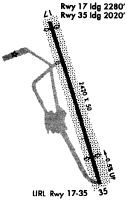
Runways
Runway Summary
| Runways: | 18/36 |
| Longest Runway: | 18/36 is 2986 ft (910 m) long |
| Runways with an Instrument Approach: |
N30 Airport Runway Details
| Runway 18/36 | 2986 ft x 50 ft (910 m x 15 m) | |
| Runway Length Source: | STATE as of 09/22/2011 | |
| Surface: | Asphalt - Fair condition - No special surface treatment | |
| Runway Edge Lights: | Non-standard lighting system Intensity | |
Runway Weight Bearing Capacity (in thousands of pounds) |
||
| Single Wheel Landing Gear: | 10.0 | |
Runway 18 |
Runway 36 |
|
Elevation: |
1346.0 | 1329.0 |
Latitude: |
41-31-10.5000N | 41-30-41.7600N |
Longitude: |
075-15-10.0500W | 075-15-01.1800W |
|
Runway True Alignment: |
167 | 347 |
Glide Path Angle: |
0.0 degrees | 0.0 degrees |
Traffic Pattern: |
Left | Left |
Runway Markings Type: |
Basic | Basic |
Runway Markings Condition: |
Good | Good |
Object at End: |
TREE | TREE |
Object Height: |
84 | 48 |
Distance from End: |
1270 | 259 |
Object Centerline Offset: |
224 ft. left of centerline | 110 ft. left of centerline |
Threshold Elevation: |
1348.0 | 1338.0 |
Displaced Threshold: |
519 | 589 |
Threshold Latitude: |
41-31-05.5051N | 41-30-47.4287N |
Threshold Longitude: |
075-15-08.5083W | 075-15-02.9293W |
Services
Airframe Repair: |
None |
Powerplant Repair: |
None |
Bottled Oxygen: |
None |
Bulk Oxygen: |
None |
Fuel Available: |
100LL |
Landing Fees: |
No |
Parking: |
Hangars and tiedowns available |
Maps & Diagrams
N30 Sectional
Flight Planning
at skyvector.com
at skyvector.com