Location
Latitude: |
30-22-16.0000N (30.371111) |
Longitude: |
104-01-03.1000W (-104.017528) |
Elevation: |
4848.8 feet MSL (1478 m MSL) |
Magnetic Variation: |
6.3 E (as of April 2024 from WMM2020 model) |
Time Zone: |
UTC -6.0 (Standard Time) UTC -5.0 (Daylight Savings Time) |
From City: |
03 N.M. N of Marfa, Texas |
Found On: |
El Paso Chart |
FAA Region: |
ASW |
Contacts
Manager: |
Publicly owned: |
| RUDY ESTOR 45101 SH 17 MARFA, TX 79843 432-295-3906 |
PRESIDIO COUNTY P.O. BOX 606 MARFA, TX 79843 432-729-4452 |
Operations
Airport Status: |
Operational |
Facility Use: |
Public |
Type: |
Airport |
Activation Date: |
01/1947 |
Control tower: |
No |
Attendance (Months/Days/Hours): |
Months/Days/Hours ALL/ALL/0800-1600 |
Boundary ARTCC: |
ZAB (Albuquerque) |
Responsible ARTCC: |
ZAB (Albuquerque) |
Lighting Schedule: |
SEE RMK |
Segmented Circle Indicator: |
Yes |
Traffic Pattern Altitude (MSL): |
5849 feet (1783 m) |
NOTAMs Facility: |
MRF |
NOTAM-D Service: |
Yes |
International Airport of Entry: |
No |
Customs Landing Rights: |
No |
Military Landing Rights: |
Yes |
Civil/Military Joint Use: |
No |
Based Aircraft
| Single Engine: | 23 |
| Multi Engine: | 1 |
| Gliders: | 6 |
Annual Operations (as of 05/16/2021)
| Total Operations: | 6000 | |
| GA Local: | 4000 | 66.7% |
| GA Itinerant: | 2000 | 33.3% |
Communications
| CTAF: | 122.800 |
| Unicom: | 122.800 |
| AWOS-3PT: | 134.025 (432-729-3364) |
- APCH/DEP SVC PRVDD BY ALBUQUERQUE ARTCC (ABQ) ON FREQS 135.875/292.15 (FORT STOCKTON RCAG).
Fixed Based Operators (FBOs) & Fuel
(Click on a business for detail)
Please help us keep this information up to date. This is a FREE SERVICE just like everything else on Airport Guide! If you see that a business needs to be added, modified, or deleted please fill out our Update Form.
To add, modify, or delete a business click here.
Please help us keep this information up to date. This is a FREE SERVICE just like everything else on Airport Guide! If you see that a business needs to be added, modified, or deleted please fill out our Update Form.
Area Code: 915 |
| Business Name | Frequency | Phone | Fuel Grade |
|---|---|---|---|
| Moore Aircraft Sales and Service
Update FBO info |
Unicom 122.8 | 729-3102 | 100LL, Jet A |
Flight Service Stations
| Primary | Alternate | |
| FSS on Field: | N | |
| FSS Name (ID): | San Angelo(SJT) | |
| Frequency: | ||
| Toll Free Phone: | 1-800-WX-BRIEF |
Instrument Procedures / Charts
FAA Terminal Procedures valid from 0901Z 03/21/24 to 0901Z 04/18/24.
There are various types of charts available for an airport. They are listed in the Page Type column. Here is a legend for those types:
APD - Airport Diagram
DP - Departure Procedure Charts
HOT - Hot Spots
IAP - Instrument Approach Procedure Charts
MIN - Minimums
STAR - Standard Terminal Arrival Charts
| Page Type | Page Name | Volume | Action Since Last Cycle |
|---|---|---|---|
| IAP | RNAV (GPS) RWY 31 | SC-3 | |
| IAP | VOR RWY 31 | SC-3 | |
| MIN | ALTERNATE MINIMUMS | SC-3 | |
| MIN | TAKEOFF MINIMUMS | SC-3 |
Terminal Procedures are only available for airports in several countries with more being added all the time. If you are looking for a specific country's charts, please send an email to support(at)airportguide.com stating the country name. This will be used to prioritize the implementation.
Navigation Aids (Navaids) near MRF
| Dist (NM) | ID | Morse Code | Name | Type | Freq | True Hdg | Mag Hdg |
|---|---|---|---|---|---|---|---|
| 5.4 | MRF | _ _ . _ . . . _ . | Marfa | VOR-DME | 115.90 | 143 | 137 |
| 19.9 | BWR | _ . . . . _ _ . _ . | Brewster County | NDB | 412 | 74 | 68 |
| 39.8 | XAA | _ . . _ . _ . _ | Kent | NDB | 225 | 345 | 339 |
| 40.9 | IMP | . . _ _ . _ _ . | Marathon | NDB | 388 | 98 | 92 |
| 57.4 | VHN | . . . _ . . . . _ . | Van Horn | NDB | 233 | 316 | 310 |
| 64.1 | FST | . . _ . . . . _ | Fort Stockton | VORTAC | 116.90 | 56 | 50 |
| 69.7 | PEQ | . _ _ . . _ _ . _ | Pecos | VOR-DME | 116.50 | 18 | 12 |
| 98.6 | INK | . . _ . _ . _ | Wink | VORTAC | 112.10 | 23 | 17 |
| 99.2 | SFL | . . . . . _ . . _ . . | Salt Flat | VORTAC | 113.00 | 326 | 319 |
Nearby Airports with Fuel
| Dist (NM) | Name (Airport IDs) | True Hdg | Mag Hdg | Fuel Grade |
|---|---|---|---|---|
| 17.3 | Alpine-Casparis Municipal Airport (ALE E38) |
87 | 81 | 100LL, Jet A, Jet A-1+ |
| 47.7 | Presidio Lely International Airport (KPRS PRS) |
202 | 196 | 100LL, Jet A |
| 57.1 | Culberson County Airport (VHN KVHN VHN) |
316 | 309 | 100LL, Jet A-1+ |
| 65.7 | Fort Stockton-Pecos County Airport (FST KFST FST) |
59 | 53 | 100LL, Jet A+ |
| 66.1 | Pecos Municipal Airport (PEQ KPEQ PEQ) |
23 | 17 | 100LL, Jet A-1+ |
| 92.4 | Roy Hurd Meml Airport (MIF E01) |
37 | 31 | 100LL, Jet A |
| 94.3 | Winkler County Airport (INK KINK INK) |
26 | 20 | 100LL, Jet A+ |
| 95.6 | Terrell County Airport (6R6) |
101 | 96 | 100LL |
Notices to Airmen (NOTAMS)
Remarks
| A110-1 | 105 FT AGL LGTD WATER TWR 1168 FT SW OF AER 31. |
| A110-2 | GLIDER OPNS ON & INVOF ARPT. |
| A110-3 | WILDLIFE ON & INVOF ARPT. |
| A110-4 | PARL TWY ADJ RWY 04/22 CLSD EXC BTN TWY A AND RWY 13/31. |
| A110-6 | FOR CD IF UNA TO CTC ON FSS FREQ, CTC ALBUQUERQUE ARTCC AT 505-856-4561. |
| A110-8 | TWY A NORTHWEST OF RWY 04/22 CLSD TO ACFT MORE THAN 18000 LB. |
| A24 | LDG FEE WAIVED WITH MIN FUEL PURCHASE. |
| A70-FUEL-10 | 0LL 100LL, JET-A, SELF SERVE AVLBL 24 HRS. |
| A76 | GLIDER INSTRUCTION ONLY |
| A81-APT | MIRL RWY 13/31 PRESET LOW INTST; TO INCR INTST ACTVT - CTAF. |
Runways
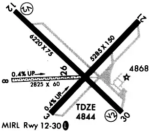
Runway Summary
| Runways: | 04/22 09/27 13/31 |
| Longest Runway: | 13/31 is 6203 ft (1891 m) long |
| Runways with an Instrument Approach: |
MRF Airport Runway Details
| Runway 04/22 | 5309 ft x 75 ft (1618 m x 23 m) | |
| Runway Length Source: | 3RD PARTY SURVEY as of 09/10/2010 | |
| Surface: | Asphalt - Good condition - No special surface treatment | |
Runway Weight Bearing Capacity (in thousands of pounds) |
||
| Single Wheel Landing Gear: | 18.0 | |
Runway 04 |
Runway 22 |
|
Elevation: |
4827.2 | 4848.7 |
Latitude: |
30-21-56.5408N | 30-22-33.4964N |
Longitude: |
104-01-13.6491W | 104-00-30.5779W |
|
Runway True Alignment: |
045 | 225 |
Glide Path Angle: |
0.0 degrees | 0.0 degrees |
Traffic Pattern: |
Left | Left |
Runway Markings Type: |
Basic | Basic |
Runway Markings Condition: |
Good | Good |
Touchdown Lights: |
No |
| Runway 09/27 | 2825 ft x 60 ft (861 m x 18 m) | |
| Runway Length Source: | 3RD PARTY SURVEY as of 09/10/2010 | |
| Surface: | Asphalt - Good condition - No special surface treatment | |
Runway 09 |
Runway 27 |
|
Elevation: |
4828.7 | 4834.5 |
Latitude: |
30-22-10.7799N | 30-22-10.4947N |
Longitude: |
104-01-31.2993W | 104-00-59.0603W |
|
Runway True Alignment: |
091 | 271 |
Glide Path Angle: |
0.0 degrees | 0.0 degrees |
Traffic Pattern: |
Left | Left |
Object at End: |
FENCE | |
Object Height: |
4 | |
Distance from End: |
132 |
| Runway 13/31 | 6203 ft x 75 ft (1891 m x 23 m) | |
| Runway Length Source: | 3RD PARTY SURVEY as of 09/10/2010 | |
| Surface: | Asphalt - Good condition - No special surface treatment | |
| Runway Edge Lights: | Medium Intensity | |
Runway Weight Bearing Capacity (in thousands of pounds) |
||
| Single Wheel Landing Gear: | 18.0 | |
Runway 13 |
Runway 31 |
|
Elevation: |
4840.5 | 4830.0 |
Latitude: |
30-22-41.0717N | 30-21-57.4249N |
Longitude: |
104-01-31.7866W | 104-00-42.0053W |
|
Runway True Alignment: |
135 | 315 |
Glide Path Angle: |
3.0 degrees | 3.0 degrees |
Traffic Pattern: |
Left | Left |
Runway Markings Type: |
Nonprecision Instrument | Nonprecision Instrument |
Runway Markings Condition: |
Good | Good |
Object at End: |
TREE | |
Object Height: |
19 | |
Distance from End: |
870 | |
Visual Glide Slope Indicators: |
2-Light PAPI On Left Side Of Runway | 2-Light PAPI On Left Side Of Runway |
Threshold Crossing Height: |
40 | 40 |
Services
Airframe Repair: |
None |
Powerplant Repair: |
None |
Fuel Available: |
100LL |
Landing Fees: |
No |
Parking: |
Tiedowns available |
Maps & Diagrams
MRF Sectional
Flight Planning
at skyvector.com
at skyvector.com