Location
Latitude: |
38-45-51.4000N (38.764278) |
Longitude: |
087-36-19.8000W (-87.6055) |
Elevation: |
429.8 feet MSL (131 m MSL) |
Magnetic Variation: |
3.8 W (as of April 2024 from WMM2020 model) |
Time Zone: |
UTC -6.0 (Standard Time) UTC -5.0 (Daylight Savings Time) |
From City: |
03 N.M. NE of Lawrenceville, Illinois |
Found On: |
St Louis Chart |
FAA Region: |
AGL |
Contacts
Manager: |
Publicly owned: |
| KURTIS SCHWARTZ 13608 HANGAR RD LAWRENCEVILLE, IL 62439 618-943-5733 |
BI-STATE AUTHORITY 13608 HANGAR RD LAWRENCEVILLE, IL 62439 618-943-5733 |
Operations
Airport Status: |
Operational |
Facility Use: |
Public |
Type: |
Airport |
Activation Date: |
10/1943 |
Control tower: |
No |
Attendance (Months/Days/Hours): |
Months/Days/Hours ALL/MON-FRI/0700-1800 |
Boundary ARTCC: |
ZID (Indianapolis) |
Responsible ARTCC: |
ZID (Indianapolis) |
Lighting Schedule: |
SEE RMK |
Traffic Pattern Altitude (MSL): |
1430 feet (436 m) |
NOTAMs Facility: |
LWV |
NOTAM-D Service: |
Yes |
International Airport of Entry: |
No |
Customs Landing Rights: |
No |
Military Landing Rights: |
Yes |
Civil/Military Joint Use: |
No |
Based Aircraft
| Single Engine: | 33 |
| Multi Engine: | 2 |
| Jet Engine: | 1 |
| Gliders: | 18 |
Annual Operations (as of 06/16/2022)
| Total Operations: | 35000 | |
| Air Taxi: | 4000 | 11.4% |
| GA Local: | 18000 | 51.4% |
| GA Itinerant: | 12700 | 36.3% |
| Military Aircraft: | 300 | 0.9% |
Communications
| CTAF: | 122.800 |
| Unicom: | 122.800 |
| Approach: | EVANSVILLE 125.6 125.6 INDIANAPOLIS ARTCC |
| Departure: | EVANSVILLE 125.6 125.6 INDIANAPOLIS ARTCC |
| ASOS: | 118.0 (618-943-5252) |
- APCH/DEP SVC PRVDD BY INDIANAPOLIS ARTCC ON FREQS 128.3/291.625 (EVANSVILLE RCAG) WHEN EVANSVILLE APCH CTL CLSD.
Fixed Based Operators (FBOs) & Fuel
(Click on a business for detail)
Please help us keep this information up to date. This is a FREE SERVICE just like everything else on Airport Guide! If you see that a business needs to be added, modified, or deleted please fill out our Update Form.
To add, modify, or delete a business click here.
Please help us keep this information up to date. This is a FREE SERVICE just like everything else on Airport Guide! If you see that a business needs to be added, modified, or deleted please fill out our Update Form.
Area Code: 618 |
| Business Name | Frequency | Phone | Fuel Grade |
|---|---|---|---|
| Mid-American Air Center
Website Update FBO info |
122.80 | 618-943-5733 | 100LL, Jet A |
| Vieke Aviation
Update FBO info |
943-5547 |
Flight Service Stations
| Primary | Alternate | |
| FSS on Field: | N | |
| FSS Name (ID): | Saint Louis(STL) | |
| Frequency: | ||
| Toll Free Phone: | 1-800-WX-BRIEF |
Instrument Procedures / Charts
FAA Terminal Procedures valid from 0901Z 03/21/24 to 0901Z 04/18/24.
There are various types of charts available for an airport. They are listed in the Page Type column. Here is a legend for those types:
APD - Airport Diagram
DP - Departure Procedure Charts
HOT - Hot Spots
IAP - Instrument Approach Procedure Charts
MIN - Minimums
STAR - Standard Terminal Arrival Charts
| Page Type | Page Name | Volume | Action Since Last Cycle |
|---|---|---|---|
| IAP | RNAV (GPS) RWY 09 | EC-3 | |
| IAP | RNAV (GPS) RWY 18 | EC-3 | |
| IAP | RNAV (GPS) RWY 27 | EC-3 | |
| IAP | RNAV (GPS) RWY 36 | EC-3 | |
| MIN | ALTERNATE MINIMUMS | EC-3 | |
| MIN | TAKEOFF MINIMUMS | EC-3 |
Terminal Procedures are only available for airports in several countries with more being added all the time. If you are looking for a specific country's charts, please send an email to support(at)airportguide.com stating the country name. This will be used to prioritize the implementation.
Navigation Aids (Navaids) near LWV
| Dist (NM) | ID | Morse Code | Name | Type | Freq | True Hdg | Mag Hdg |
|---|---|---|---|---|---|---|---|
| 0.3 | LWV | . _ . . . _ _ . . . _ | Lawrenceville | DME | 108.8 | 13 | 17 |
| 5.0 | OEA | _ _ _ . . _ | Vincennes | NDB | 251 | 152 | 156 |
| 15.1 | PLX | . _ _ . . _ . . _ . . _ | Palestine | NDB | 391 | 353 | 357 |
| 15.3 | RSV | . _ . . . . . . . _ | Robinson | VOR-DME | 108.40 | 352 | 356 |
| 22.2 | SIV | . . . . . . . . _ | Sullivan | NDB | 326 | 19 | 23 |
| 26.7 | OLY | _ _ _ . _ . . _ . _ _ | Olney | NDB | 272 | 264 | 268 |
| 28.1 | SAM | . . . . _ _ _ | Samsville | DME | 116.6 | 233 | 237 |
| 37.3 | CZB | _ . _ . _ _ . . _ . . . | Casey | NDB | 359 | 330 | 334 |
| 38.6 | HU | . . . . . . _ | Yinno | NDB | 245 | 14 | 18 |
| 42.0 | BIB | _ . . . . . _ . . . | Bible Grove | VORTAC | 109.00 | 283 | 287 |
| 43.4 | HNB | . . . . _ . _ . . . | Huntingburg | VOR-DME | 109.20 | 135 | 139 |
| 43.6 | PDW | . _ _ . _ . . . _ _ | Evansville | NDB | 284 | 175 | 179 |
| 44.2 | FWC | . . _ . . _ _ _ . _ . | Wayne County | NDB | 257 | 238 | 242 |
| 46.5 | TTH | _ _ . . . . | Terre Haute | VORTAC | 115.30 | 20 | 24 |
| 48.5 | MT | _ _ _ | Zebre | NDB | 347 | 327 | 331 |
| 50.7 | PXV | . _ _ . _ . . _ . . . _ | Pocket City | VORTAC | 113.30 | 188 | 192 |
| 51.6 | OOM | _ _ _ _ _ _ _ _ | Hoosier | VORTAC | 110.20 | 63 | 67 |
| 53.3 | MTO | _ _ _ _ _ _ | Mattoon | DME | 109.4 | 323 | 327 |
| 54.9 | BFR | _ . . . . . _ . . _ . | Bedford | NDB | 344 | 84 | 88 |
| 61.3 | VNN | . . . _ _ . _ . | Mount Vernon | DME | 113.8 | 247 | 250 |
Nearby Airports with Fuel
Notices to Airmen (NOTAMS)
Remarks
| A11 | JOINT OWNED - CITY OF VINCENNES IN & LAWRENCEVILLE IL. |
| A110-1 | GLIDER ACTVTY SR-SS. RYS 09/27 & 18/36 HAVE LEFT HAND TFC PATTERN FOR GLIDER ACFT. |
| A110-4 | BE ALERT; ODALS FOR RY 27 ARE IN OPERATION SIMULTANEOUSLY WITH REILS ON RY 18. |
| A110-5 | FOR CD WHEN RCO 125.6 OTS, CTC EVANSVILLE APCH AT 812-436-4689, WHEN APCH CLSD CTC INDIANAPOLIS ARTCC AT 317-247-2411. |
| A16 | 812-881-7042. |
| A43-09 | PVASI UNUSBL BYD 8 DEGREES LEFT OF CNTRLN & BYD 6 DEGREES RIGHT OF CNTRLN. |
| A43-18 | PVASI UNUSBL BYD 8 DEGREES LEFT OF CNTRLN & BYD 6 DEGREES RIGHT OF CNTRLN. |
| A81-APT | ACTVT ODALS RWY 27; REIL RWY 9, 27, 18 & 36; PAPI RWY 36; MIRL RWY 09/27 - CTAF. MIRL RWY 18/36 PRESET ON LOW INTST TO INCR INTST - CTAF. |
| A84 | TRAFFIC PATTERN INDICATORS ON SOD RUNWAY 4U/22U |
| E111 | EXISTED PRIOR TO 1959. |
| E147 | RWY 09/27 & 18/36 900 FT AGL PWRD ACFT; RWY 04U/22U 500 FT AGL MAX ULTRALIGHTS. |
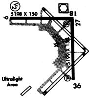
Runways
Runway Summary
| Runways: | 04U/22U 09/27 18/36 |
| Longest Runway: | 18/36 is 5199 ft (1585 m) long |
| Runways with an Instrument Approach: |
LWV Airport Runway Details
| Runway 04U/22U | 1000 ft x 200 ft (305 m x 61 m) | |
| Surface: | Turf - Fair condition - No special surface treatment | |
Runway 04U |
Runway 22U |
|
Glide Path Angle: |
0.0 degrees | 0.0 degrees |
Traffic Pattern: |
Left | Right |
| Runway 09/27 | 5198 ft x 100 ft (1584 m x 30 m) | |
| Runway Length Source: | 3RD PARTY SURVEY as of 03/11/2009 | |
| Surface: | Turf - Fair condition - No special surface treatment | |
| Runway Edge Lights: | Medium Intensity | |
Runway Weight Bearing Capacity (in thousands of pounds) |
||
| Single Wheel Landing Gear: | 75.0 | |
| Dual Wheel Landing Gear: | 100.0 | |
| Dual Tandem Wheel Landing Gear: | 180.0 | |
Runway 09 |
Runway 27 |
|
Elevation: |
425.6 | 429.5 |
Latitude: |
38-46-03.5188N | 38-46-04.0376N |
Longitude: |
087-37-08.7204W | 087-36-03.0985W |
|
Runway True Alignment: |
089 | 269 |
Glide Path Angle: |
3.0 degrees | 3.0 degrees |
Traffic Pattern: |
Left | Left |
Runway Markings Type: |
Nonprecision Instrument | Nonprecision Instrument |
Runway Markings Condition: |
Good | Good |
Visual Glide Slope Indicators: |
Pulsating/Steady Burning VASI On Left Side Of Runway | 4-Light PAPI On Left Side Of Runway |
Approach Light System: |
Omnidirectional Approach Lighting System | |
REIL: |
Yes | Yes |
Touchdown Lights: |
No | No |
Centerline Lights: |
No | No |
Threshold Crossing Height: |
26 | 26 |
| Runway 18/36 | 5199 ft x 100 ft (1585 m x 30 m) | |
| Runway Length Source: | 3RD PARTY SURVEY as of 03/11/2009 | |
| Surface: | Turf - Fair condition - No special surface treatment | |
| Runway Edge Lights: | Medium Intensity | |
Runway Weight Bearing Capacity (in thousands of pounds) |
||
| Single Wheel Landing Gear: | 75.0 | |
| Dual Wheel Landing Gear: | 100.0 | |
| Dual Tandem Wheel Landing Gear: | 180.0 | |
Runway 18 |
Runway 36 |
|
Elevation: |
429.4 | 424.9 |
Latitude: |
38-46-04.7628N | 38-45-13.3756N |
Longitude: |
087-36-04.0368W | 087-36-03.4458W |
|
Runway True Alignment: |
179 | 359 |
Glide Path Angle: |
3.0 degrees | 3.0 degrees |
Traffic Pattern: |
Left | Left |
Runway Markings Type: |
Nonprecision Instrument | Nonprecision Instrument |
Runway Markings Condition: |
Fair | Fair |
Visual Glide Slope Indicators: |
Pulsating/Steady Burning VASI On Left Side Of Runway | 4-Light PAPI On Left Side Of Runway |
REIL: |
Yes | Yes |
Touchdown Lights: |
No | No |
Centerline Lights: |
No | No |
Threshold Crossing Height: |
25 | 41 |
Services
Bottled Oxygen: |
None |
Bulk Oxygen: |
None |
Fuel Available: |
100LL, Jet A |
Landing Fees: |
No |
Parking: |
Hangars and tiedowns available |
Maps & Diagrams
LWV Sectional
Flight Planning
at skyvector.com
at skyvector.com