Location
Latitude: |
40-51-03.2090N (40.850891) |
Longitude: |
096-45-32.8360W (-96.759121) |
Elevation: |
1218.7 feet MSL (371 m MSL) |
Magnetic Variation: |
2.7 E (as of April 2024 from WMM2020 model) |
Time Zone: |
UTC -6.0 (Standard Time) UTC -5.0 (Daylight Savings Time) |
From City: |
04 N.M. NW of Lincoln, Nebraska |
Found On: |
Omaha Chart |
FAA Region: |
ACE |
Contacts
Manager: |
Publicly owned: |
| MR. DAVID HARING LINCOLN AIRPORT AUTHORITY, P.O. BOX 80407 LINCOLN, NE 68501 402-458-2400 |
LINCOLN ARPT AUTH BOX 80407 LINCOLN, NE 68501 402-458-2400 |
Operations
Airport Status: |
Operational |
Facility Use: |
Public |
Type: |
Airport |
Activation Date: |
04/1940 |
Control tower: |
Yes |
Attendance (Months/Days/Hours): |
Months/Days/Hours ALL/ALL/ALL |
Boundary ARTCC: |
ZMP (Minneapolis) |
Responsible ARTCC: |
ZMP (Minneapolis) |
Lighting Schedule: |
SEE RMK |
Segmented Circle Indicator: |
No |
Traffic Pattern Altitude (MSL): |
2219 feet (676 m) |
NOTAMs Facility: |
LNK |
NOTAM-D Service: |
Yes |
International Airport of Entry: |
No |
Customs Landing Rights: |
No |
Military Landing Rights: |
Yes |
Civil/Military Joint Use: |
No |
Aircraft Rescue and Firefighting: |
Class I ARFF Index: B Air Carrier Service: Scheduled Certification Date: 05/1973 |
Based Aircraft
| Single Engine: | 115 |
| Multi Engine: | 14 |
| Jet Engine: | 21 |
| GA Helicopters: | 2 |
| Military Aircraft: | 22 |
Annual Operations (as of 05/31/2023)
| Total Operations: | 74896 | |
| Commercial: | 5165 | 6.9% |
| Air Taxi: | 9099 | 12.1% |
| GA Local: | 20182 | 26.9% |
| GA Itinerant: | 26125 | 34.9% |
| Military Aircraft: | 14325 | 19.1% |
Communications
| CTAF: | 118.500 |
| Unicom: | 122.950 |
| Tower: | LINCOLN 118.5 253.5 125.7 Hrs: 0600 - 2200 |
| Clearance Del.: | 120.7 225.4 |
| Ground: | 121.9 275.8 |
| Approach: | OMAHA 124.0 124.0 124.0 124.0 |
| Departure: | OMAHA 124.0 124.0 124.0 124.0 |
| ATIS: | 118.05 290.9 Hrs: 24 |
| ASOS: | (402-474-9214) |
| ARNG OPS: | 255.8 |
| ARNG OPS: | 30.1FM |
| ARNG OPS: | 138.75 |
| ANG OPS: | 234.65 |
Fixed Based Operators (FBOs) & Fuel
(Click on a business for detail)
Please help us keep this information up to date. This is a FREE SERVICE just like everything else on Airport Guide! If you see that a business needs to be added, modified, or deleted please fill out our Update Form.
To add, modify, or delete a business click here.
Please help us keep this information up to date. This is a FREE SERVICE just like everything else on Airport Guide! If you see that a business needs to be added, modified, or deleted please fill out our Update Form.
Area Code: 402 |
| Business Name | Frequency | Phone | Fuel Grade |
|---|---|---|---|
| Capitol Aviation
Website Update FBO info |
Unicom 122.95 | 475-5444 | 100LL, Jet A |
| Duncan Aviation
Website Update FBO info |
Unicom 122.95, Arinc 128.95 | 475-2611, 800-228-4277 | 100LL, Jet A |
| Silverhawk Aviation
Website Update FBO info |
Unicom 122.95 | 475-8600, 800-479-5851 | 100LL, Jet A |

|
Air Bp | 100LL - 2.65 USD per gallon on 9/24/01 |
Pumps |
|
|
Air Bp | Jet A - 2.32 USD per gallon on 9/24/01 |
Pumps |
Flight Service Stations
| Primary | Alternate | |
| FSS on Field: | N | |
| FSS Name (ID): | Columbus(OLU) | |
| Frequency: | ||
| Toll Free Phone: | 1-800-WX-BRIEF |
Instrument Procedures / Charts
FAA Terminal Procedures valid from 0901Z 03/21/24 to 0901Z 04/18/24.
There are various types of charts available for an airport. They are listed in the Page Type column. Here is a legend for those types:
APD - Airport Diagram
DP - Departure Procedure Charts
HOT - Hot Spots
IAP - Instrument Approach Procedure Charts
MIN - Minimums
STAR - Standard Terminal Arrival Charts
| Page Type | Page Name | Volume | Action Since Last Cycle |
|---|---|---|---|
| APD | AIRPORT DIAGRAM | NC-2 | |
| HOT | HOT SPOT | NC-2 | |
| IAP | HI-ILS Z OR LOC Z RWY 18 | NC-2 | |
| IAP | HI-ILS Z OR LOC Z RWY 36 | NC-2 | |
| IAP | HI-VOR Z OR TACAN RWY 18 | NC-2 | |
| IAP | HI-VOR/DME OR TACAN RWY 36 | NC-2 | |
| IAP | ILS Y OR LOC Y RWY 18 | NC-2 | |
| IAP | ILS Y OR LOC Y RWY 36 | NC-2 | |
| IAP | RNAV (GPS) RWY 14 | NC-2 | |
| IAP | RNAV (GPS) RWY 17 | NC-2 | |
| IAP | RNAV (GPS) RWY 18 | NC-2 | |
| IAP | RNAV (GPS) RWY 32 | NC-2 | |
| IAP | RNAV (GPS) RWY 35 | NC-2 | |
| IAP | RNAV (GPS) RWY 36 | NC-2 | |
| IAP | VOR RWY 17 | NC-2 | |
| IAP | VOR Y RWY 18 | NC-2 | |
| MIN | ALTERNATE MINIMUMS | NC-2 | |
| MIN | TAKEOFF MINIMUMS | NC-2 |
Terminal Procedures are only available for airports in several countries with more being added all the time. If you are looking for a specific country's charts, please send an email to support(at)airportguide.com stating the country name. This will be used to prioritize the implementation.
Navigation Aids (Navaids) near LNK
| Dist (NM) | ID | Morse Code | Name | Type | Freq | True Hdg | Mag Hdg |
|---|---|---|---|---|---|---|---|
| 4.4 | LNK | . _ . . _ . _ . _ | Lincoln | VORTAC | 116.10 | 10 | 7 |
| 6.2 | LN | . _ . . _ . | Potts | NDB | 385 | 181 | 178 |
| 16.0 | SWT | . . . . _ _ _ | Seward | NDB | 269 | 272 | 269 |
| 24.4 | AHQ | . _ . . . . _ _ . _ | Wahoo | NDB | 400 | 17 | 14 |
| 33.0 | BIE | _ . . . . . . | Beatrice | VOR | 110.60 | 179 | 176 |
| 35.8 | MLE | _ _ . _ . . . | Millard | NDB | 371 | 54 | 52 |
| 38.8 | PMV | . _ _ . _ _ . . . _ | Plattsmouth | NDB | 329 | 81 | 79 |
| 39.0 | JYR | . _ _ _ _ . _ _ . _ . | York | NDB | 257 | 274 | 271 |
| 40.0 | FMZ | . . _ . _ _ _ _ . . | Beklof | NDB | 392 | 247 | 244 |
| 42.1 | OFF | _ _ _ . . _ . . . _ . | Offutt | TACAN | 111.70 | 67 | 65 |
| 43.4 | AFK | . _ . . _ . _ . _ | Nebraska City | NDB | 347 | 109 | 107 |
| 44.5 | FBY | . . _ . _ . . . _ . _ _ | Fairbury | NDB | 293 | 204 | 201 |
| 44.5 | OLU | _ _ _ . _ . . . . _ | Columbus | VOR-DME | 111.80 | 324 | 321 |
| 45.6 | SCB | . . . _ . _ . _ . . . | Scribner | VOR-DME | 111.00 | 7 | 4 |
| 46.5 | PWE | . _ _ . . _ _ . | Pawnee City | DME | 112.4 | 146 | 144 |
| 47.6 | OMA | _ _ _ _ _ . _ | Omaha | VOT | 109.00 | 55 | 53 |
| 47.7 | OM | _ _ _ _ _ | Gerfi | NDB | 320 | 49 | 47 |
| 47.9 | PLT | . _ _ . . _ . . _ | Platte Center | NDB | 407 | 324 | 321 |
| 48.0 | EN | . _ . | Rikky | NDB | 426 | 62 | 60 |
| 50.0 | OVR | _ _ _ . . . _ . _ . | Omaha | VORTAC | 116.30 | 67 | 65 |
Nearby Airports with Fuel
Notices to Airmen (NOTAMS)
Remarks
| A110-1 | BIRDS INVOF ARPT. |
| A110-10 | ANG: CTC AM OPS 234.65 20 MIN PRIOR TO LDG. |
| A110-11 | ANG: PROVISIONAL PORT OF ENTRY: US CUSTOMS AVBL ONLY WITH 24 HR NOTICE AND ONLY FOR DOD AIRCREW AND DOD DUTY PAX ON TRAVEL ORDERS. CTC COMD POST. SPACE-A US CUSTOMS ENTRY TO THE US AT THIS ARPT LIMITED TO ACTIVE DUTY MILITARY PERSONNEL ON LEAVE (NO DEPENDENTS). |
| A110-12 | ARNG: OPR 1300-2100Z++ TUE-FRI, LTD TRAN MAINT. |
| A110-13 | ARNG: RAMP IS OFFL BUS/PPR TO PRK ARNG RAMP CTC FLT OPS DSN 279-1844, C402-309-1844. |
| A110-14 | ENSURE CORRECT RWY LINEUP. RWY 17/35 IS THE SHRTR, PARL RWY ON E SIDE OF ARPT. |
| A110-15 | ANG: AM OPS DSN 279-1293; C402-309-1293. |
| A110-16 | PPR 24 HRS FOR ACFT PARKING ON THE WEST RAMP - CTC ARPT 402-458-2480. |
| A110-17 | ANG: CTC AM OPS 234.65 FOR BWC. |
| A110-18 | FOR CD WHEN ATCT IS CLSD CTC OMAHA APCH AT 402-682-4395. |
| A110-19 | AF: USAF TMPRY OPS ON WEST RAMP FR APRX SPRING 2021 TO FALL 2022. |
| A110-5 | PPR TO PARK ON ANG RAMP. |
| A14 | EXECUTIVE DIRECTOR. |
| A26 | INDEX C LVL ARFF EQPT PRVDD; FOR ARFF SVC - CTAF. |
| A30A-18 | CALM WIND RWY. |
| A30A-32 | APCH HOLDLINE ON SOUTH TWY A. |
| A43-32 | VASI UNUSBL BYD 8 DEGS LEFT OF CNTRLN AND 6 DEGS RIGHT OF CNTRLN. |
| A57-32 | APCH RATIO FM DSPLCD THR 49:1. |
| A81-APT | WHEN ATCT CLSD, MALSR RWYS 18 & 36 OPR CONSLY ON LOW INTST; ODALS RWY 35 OPR CONSLY ON MED INTST; REIL RWY 14 OPR CONSLY ON LOW INTST; REIL RWY 17 OPR CONSLY ON MED INTST; MIRL RWY 14/32 AND RWY 17/35 OPR CONSLY ON LOW INTST; HIRL RWY 18/36 OPR CONSLY ON MED INTST. VASI RWY 32; PAPI RWYS 14, 17, 18, 35, & 36 OPR CONSLY. |
| E147 | HVY MIL JET TPA 1781 FT AGL |
Runways
Runway Summary
| Runways: | 14/32 17/35 18/36 |
| Longest Runway: | 18/36 is 12901 ft (3932 m) long |
| Runways with an Instrument Approach: | 18, 36 |
LNK Airport Runway Details
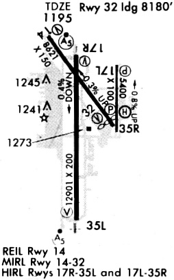
| Runway 14/32 | 8649 ft x 150 ft (2636 m x 46 m) | |
| Runway Length Source: | 3RD PARTY SURVEY as of 01/22/2021 | |
| Surface: | Asphalt - Fair condition - Saw-cut or plastic grooved | |
| Runway Pavement Class: | 43 /F/B/X/U | |
| Runway Edge Lights: | Medium Intensity | |
Runway Weight Bearing Capacity (in thousands of pounds) |
||
| Single Wheel Landing Gear: | 80.0 | |
| Dual Wheel Landing Gear: | 170.0 | |
| Dual Tandem Wheel Landing Gear: | 280.0 | |
Runway 14 |
Runway 32 |
|
Elevation: |
1198.9 | 1177.7 |
Latitude: |
40-52-02.2980N | 40-50-52.2648N |
Longitude: |
096-46-10.8326W | 096-45-06.3314W |
|
Runway True Alignment: |
145 | 325 |
Glide Path Angle: |
3.0 degrees | 3.0 degrees |
Traffic Pattern: |
Left | Left |
Runway Markings Type: |
Nonprecision Instrument | Nonprecision Instrument |
Runway Markings Condition: |
Good | Good |
Object at End: |
POLE | |
Object Height: |
59 | |
Distance from End: |
2475 | |
Object Centerline Offset: |
375 ft. right of centerline | |
Visual Glide Slope Indicators: |
4-Light PAPI On Left Side Of Runway | 4-Box VASI On Left Side Of Runway |
REIL: |
Yes | |
Threshold Crossing Height: |
48 | 54 |
Threshold Elevation: |
1199.0 | 1179.0 |
Displaced Threshold: |
363 | 470 |
Threshold Latitude: |
40-51-59.3609N | 40-50-56.0687N |
Threshold Longitude: |
096-46-08.1303W | 096-45-09.8338W |
Declared Distances |
||
Take Off Run Avbl. (TORA): |
8649 | 8649 |
Take Off Distance Avbl. (TODA): |
8649 | 8649 |
Actual Stop Dist. Avbl. (ASDA): |
8649 | 8286 |
Landing Dist. Avbl. (LDA): |
8286 | 7816 |
| Runway 17/35 | 5801 ft x 100 ft (1768 m x 30 m) | |
| Runway Length Source: | 3RD PARTY SURVEY as of 01/22/2021 | |
| Surface: | Asphalt - Fair condition - Saw-cut or plastic grooved | |
| Runway Pavement Class: | 15 /R/C/W/T | |
| Runway Edge Lights: | Medium Intensity | |
Runway Weight Bearing Capacity (in thousands of pounds) |
||
| Single Wheel Landing Gear: | 45.0 | |
| Dual Wheel Landing Gear: | 59.0 | |
Runway 17 |
Runway 35 |
|
Elevation: |
1218.7 | 1173.0 |
Latitude: |
40-51-40.8329N | 40-50-43.5241N |
Longitude: |
096-45-02.7157W | 096-45-03.0869W |
|
Runway True Alignment: |
180 | 360 |
Glide Path Angle: |
3.0 degrees | 3.0 degrees |
Traffic Pattern: |
Left | Right |
Runway Markings Type: |
Nonprecision Instrument | Nonprecision Instrument |
Runway Markings Condition: |
Good | Good |
Object Centerline Offset: |
375 ft. right of centerline | |
Visual Glide Slope Indicators: |
4-Light PAPI On Left Side Of Runway | 4-Light PAPI On Left Side Of Runway |
Approach Light System: |
Omnidirectional Approach Lighting System | |
REIL: |
Yes | No |
Threshold Crossing Height: |
44 | 30 |
Declared Distances |
||
Take Off Run Avbl. (TORA): |
5800 | 5800 |
Take Off Distance Avbl. (TODA): |
5800 | 5800 |
Actual Stop Dist. Avbl. (ASDA): |
5400 | 5800 |
Landing Dist. Avbl. (LDA): |
5400 | 5800 |
| Runway 18/36 | 12901 ft x 200 ft (3932 m x 61 m) | |
| Runway Length Source: | 3RD PARTY SURVEY as of 01/22/2021 | |
| Surface: | Asphalt - Fair condition - Saw-cut or plastic grooved | |
| Runway Pavement Class: | 58 /R/B/W/U | |
| Runway Edge Lights: | High Intensity | |
Runway Weight Bearing Capacity (in thousands of pounds) |
||
| Single Wheel Landing Gear: | 100.0 | |
| Dual Wheel Landing Gear: | 200.0 | |
| Dual Tandem Wheel Landing Gear: | 400.0 | |
Runway 18 |
Runway 36 |
|
Elevation: |
1195.2 | 1174.7 |
Latitude: |
40-51-46.7698N | 40-49-39.3030N |
Longitude: |
096-45-42.0323W | 096-45-42.8579W |
|
Runway True Alignment: |
180 | 360 |
ILS Type: |
ILS | ILS |
Glide Path Angle: |
3.0 degrees | 3.0 degrees |
Traffic Pattern: |
Right | Left |
Runway Markings Type: |
Precision Instrument | Precision Instrument |
Runway Markings Condition: |
Good | Good |
Object Centerline Offset: |
375 ft. right of centerline | |
Visual Glide Slope Indicators: |
4-Light PAPI On Left Side Of Runway | 4-Light PAPI On Left Side Of Runway |
Runway Visual Range (RVR): |
Touchdown, Rollout | Touchdown, Rollout |
Approach Light System: |
1,400 Foot Medium Intensity Approach Lighting System With Runway Alignment Indicator Lights | 1,400 Foot Medium Intensity Approach Lighting System With Runway Alignment Indicator Lights |
Threshold Crossing Height: |
55 | 56 |
Declared Distances |
||
Take Off Run Avbl. (TORA): |
12901 | 12901 |
Take Off Distance Avbl. (TODA): |
12901 | 12901 |
Actual Stop Dist. Avbl. (ASDA): |
12901 | 12901 |
Landing Dist. Avbl. (LDA): |
12901 | 12901 |
Services
Airframe Repair: |
Major |
Powerplant Repair: |
None |
Bottled Oxygen: |
None |
Bulk Oxygen: |
None |
Fuel Available: |
100LL |
Landing Fees: |
No |
Parking: |
Hangars and tiedowns available |
Maps & Diagrams
LNK Sectional
Flight Planning
at skyvector.com
at skyvector.com