Location
Latitude: |
40-24-44.3000N (40.412306) |
Longitude: |
086-56-12.8000W (-86.936889) |
Elevation: |
605.9 feet MSL (185 m MSL) |
Magnetic Variation: |
4.5 W (as of April 2024 from WMM2020 model) |
Time Zone: |
UTC -5.0 (Standard Time) UTC -4.0 (Daylight Savings Time) |
From City: |
02 N.M. SW of Lafayette, Indiana |
Found On: |
Chicago Chart |
FAA Region: |
AGL |
Contacts
Manager: |
Publicly owned: |
| ADAM BAXMEYER 1501 AVIATION DRIVE, TRML BLDG ROOM 201 WEST LAFAYETTE, IN 47907 (765) 496-6850 |
PURDUE UNIVERSITY 1501 AVIATION DRIVE, TRML BLDG ROOM 201 WEST LAFAYETTE, IN 47907 (765) 496-6326 |
Operations
Airport Status: |
Operational |
Facility Use: |
Public |
Type: |
Airport |
Activation Date: |
04/1940 |
Control tower: |
Yes |
Attendance (Months/Days/Hours): |
Months/Days/Hours ALL/MON-FRI/0800-1700 |
Boundary ARTCC: |
ZAU (Chicago) |
Responsible ARTCC: |
ZAU (Chicago) |
Lighting Schedule: |
SEE RMK |
Segmented Circle Indicator: |
No |
Traffic Pattern Altitude (MSL): |
1606 feet (490 m) |
NOTAMs Facility: |
LAF |
NOTAM-D Service: |
Yes |
International Airport of Entry: |
No |
Customs Landing Rights: |
No |
Military Landing Rights: |
Yes |
Civil/Military Joint Use: |
No |
Aircraft Rescue and Firefighting: |
Class IV ARFF Index: A Air Carrier Service: Not Scheduled Certification Date: 11/1972 |
Based Aircraft
| Single Engine: | 81 |
| Multi Engine: | 8 |
| Jet Engine: | 3 |
| GA Helicopters: | 2 |
Annual Operations (as of 12/31/2022)
| Total Operations: | 117670 | |
| Commercial: | 130 | 0.1% |
| Air Taxi: | 29454 | 25.0% |
| GA Local: | 54904 | 46.7% |
| GA Itinerant: | 33147 | 28.2% |
| Military Aircraft: | 35 | 0.0% |
Communications
| CTAF: | 119.600 |
| Unicom: | 122.950 |
| Tower: | LAFAYETTE 119.6 343.625 Hrs: 0700-2100 |
| Ground: | 121.9 343.625 |
| Approach: | GRISSOM 123.85 123.85 CHICAGO ARTCC |
| Departure: | GRISSOM 123.85 123.85 CHICAGO ARTCC |
| ATIS: | 127.75 |
| ASOS: | (765-743-9687) |
| EMERG: | 243.0 |
- APCH/DEP SVC PRVDD BY CHICAGO ARTCC ON FREQ 123.85 (LAFAYETTE RCAG) WHEN GRISSOM (GUS) APCH/DEP CON CLSD..
Fixed Based Operators (FBOs) & Fuel
(Click on a business for detail)
Please help us keep this information up to date. This is a FREE SERVICE just like everything else on Airport Guide! If you see that a business needs to be added, modified, or deleted please fill out our Update Form.
To add, modify, or delete a business click here.
Please help us keep this information up to date. This is a FREE SERVICE just like everything else on Airport Guide! If you see that a business needs to be added, modified, or deleted please fill out our Update Form.
Area Code: 765 |
| Business Name | Frequency | Phone | Fuel Grade |
|---|---|---|---|
| Lafayette Aviation, Inc.
Update FBO info |
Unicom 122.95 | 743-9692 | 100LL, Jet A |
| Lafayette Avionics, Inc.
Update FBO info |
743-3828 |
Flight Service Stations
| Primary | Alternate | |
| FSS on Field: | N | |
| FSS Name (ID): | Terre Haute(HUF) | |
| Frequency: | ||
| Toll Free Phone: | 1-800-WX-BRIEF |
Instrument Procedures / Charts
FAA Terminal Procedures valid from 0901Z 03/21/24 to 0901Z 04/18/24.
There are various types of charts available for an airport. They are listed in the Page Type column. Here is a legend for those types:
APD - Airport Diagram
DP - Departure Procedure Charts
HOT - Hot Spots
IAP - Instrument Approach Procedure Charts
MIN - Minimums
STAR - Standard Terminal Arrival Charts
| Page Type | Page Name | Volume | Action Since Last Cycle |
|---|---|---|---|
| APD | AIRPORT DIAGRAM | EC-2 | |
| HOT | HOT SPOT | EC-2 | |
| IAP | ILS OR LOC RWY 10 | EC-2 | |
| IAP | RNAV (GPS) RWY 10 | EC-2 | |
| IAP | RNAV (GPS) RWY 28 | EC-2 | |
| IAP | VOR-A | EC-2 | |
| LAH | LAHSO | EC-2 | |
| MIN | ALTERNATE MINIMUMS | EC-2 | |
| MIN | TAKEOFF MINIMUMS | EC-2 |
Terminal Procedures are only available for airports in several countries with more being added all the time. If you are looking for a specific country's charts, please send an email to support(at)airportguide.com stating the country name. This will be used to prioritize the implementation.
Navigation Aids (Navaids) near LAF
| Dist (NM) | ID | Morse Code | Name | Type | Freq | True Hdg | Mag Hdg |
|---|---|---|---|---|---|---|---|
| 5.3 | LA | . _ . . . _ | Earle | NDB | 401 | 279 | 283 |
| 10.5 | BVT | _ . . . . . . _ _ | Boiler | VORTAC | 115.10 | 325 | 329 |
| 19.1 | FKR | . . _ . _ . _ . _ . | Frankfort | NDB | 278 | 116 | 121 |
| 25.9 | CFJ | _ . _ . . . _ . . _ _ _ | Crawfordsville | NDB | 388 | 177 | 182 |
| 28.1 | DN | _ . . _ . | Julip | NDB | 332 | 255 | 259 |
| 29.2 | DNV | _ . . _ . . . . _ | Danville | VORTAC | 111.00 | 256 | 260 |
| 38.4 | GUS | _ _ . . . _ . . . | Grissom | VORTAC | 108.45 | 68 | 73 |
| 40.7 | OKK | _ _ _ _ . _ _ . _ | Kokomo | TACAN | 113.50 | 79 | 84 |
| 42.3 | TVX | _ . . . _ _ . . _ | Greencastle | NDB | 521 | 171 | 176 |
| 43.6 | RWN | . _ . . _ _ _ . | Winamac/Dcmsnd | NDB | 335 | 20 | 25 |
| 44.4 | VHP | . . . _ . . . . . _ _ . | Brickyard | VORTAC | 116.30 | 143 | 148 |
| 49.6 | UMP | . . _ _ _ . _ _ . | Metropolitan | NDB | 338 | 124 | 129 |
| 50.0 | IND | . . _ . _ . . | Indianapolis Intl | VOT | 109.60 | 144 | 149 |
| 52.0 | HMJ | . . . . _ _ . _ _ _ | Homer | NDB | 281 | 243 | 247 |
| 54.4 | CPB | _ . _ . . _ _ . _ . . . | Culver | NDB | 391 | 27 | 32 |
| 56.0 | IWH | . . . _ _ . . . . | Wabash | NDB | 329 | 67 | 72 |
| 56.1 | OXI | _ _ _ _ . . _ . . | Knox | DME | 115.6 | 13 | 18 |
| 56.9 | RBS | . _ . _ . . . . . . | Roberts | VOR-DME | 116.80 | 280 | 284 |
| 57.0 | IK | . . _ . _ | Lukow | NDB | 272 | 309 | 313 |
| 57.2 | TTH | _ _ . . . . | Terre Haute | VORTAC | 115.30 | 194 | 198 |
Nearby Airports with Fuel
Notices to Airmen (NOTAMS)
Remarks
| A110-5 | TRNG OPS & BIRDS INVOF ARPT. |
| A110-6 | SFC COND UNMNT 2200-0600 OR WKEND. |
| A110-7 | FOR CD IF UNA TO CTC ON FSS FREQ, CTC CHICAGO ARTCC AT 630-906-8921. |
| A26 | CLSD TO SKED ACR OPS GTR THAN 9 PAX SEATS. UNSKED ACR OPS GTR THAN 30 PAX SEATS PPR - 765-496-6326 OR 765-496-4057. INDEX B ARFF CAPABILITY AVBL ON REQ. |
| A30-05/23 | WINGSPAN GTR THAN 79 FT & UNSKED ACR 31 PAX OR MORE NA. |
| A43-10 | PAPI UNUSBL BYD 9 DEGS RIGHT OF CNTRLN. |
| A57-23 | 20:1 AT DSPLCD THR. |
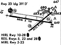
| A81-APT | WHEN ATCT CLSD ACTVT MALSR RWY 10; REIL RWY 5, 23 & 28; MIRL RWY 5/23; HIRL RWY 10/28 - CTAF. |
Runways
Runway Summary
| Runways: | 05/23 10/28 |
| Longest Runway: | 10/28 is 6600 ft (2012 m) long |
| Runways with an Instrument Approach: | 10 |
LAF Airport Runway Details
| Runway 05/23 | 4225 ft x 100 ft (1288 m x 30 m) | |
| Runway Length Source: | 3RD PARTY SURVEY as of 12/06/2012 | |
| Surface: | Asphalt - Good condition - No special surface treatment | |
| Runway Pavement Class: | 17 /F/C/Y/T | |
| Runway Edge Lights: | Medium Intensity | |
Runway Weight Bearing Capacity (in thousands of pounds) |
||
| Single Wheel Landing Gear: | 48.0 | |
| Dual Wheel Landing Gear: | 58.0 | |
| Dual Tandem Wheel Landing Gear: | 90.0 | |
Runway 05 |
Runway 23 |
|
Elevation: |
592.5 | 605.6 |
Latitude: |
40-24-29.4629N | 40-24-56.5614N |
Longitude: |
086-56-20.4724W | 086-55-38.9302W |
|
Runway True Alignment: |
050 | 230 |
Glide Path Angle: |
3.0 degrees | 3.0 degrees |
Traffic Pattern: |
Left | Left |
Runway Markings Type: |
Basic | Basic |
Runway Markings Condition: |
Fair | Good |
Object at End: |
FENCE | |
Object Height: |
11 | |
Distance from End: |
287 | |
Object Centerline Offset: |
132 ft. left of centerline | |
Visual Glide Slope Indicators: |
2-Light PAPI On Left Side Of Runway | 2-Light PAPI On Left Side Of Runway |
REIL: |
Yes | Yes |
Touchdown Lights: |
No | No |
Centerline Lights: |
No | No |
Threshold Crossing Height: |
38 | 39 |
Threshold Elevation: |
602.7 | |
Displaced Threshold: |
323 | |
Threshold Latitude: |
40-24-54.4917N | |
Threshold Longitude: |
086-55-42.1043W | |
Declared Distances |
||
Take Off Run Avbl. (TORA): |
4225 | 4225 |
Take Off Distance Avbl. (TODA): |
4225 | 4225 |
Actual Stop Dist. Avbl. (ASDA): |
4225 | 4225 |
Landing Dist. Avbl. (LDA): |
4225 | 3912 |
| Runway 10/28 | 6600 ft x 150 ft (2012 m x 46 m) | |
| Runway Length Source: | 3RD PARTY SURVEY as of 12/06/2012 | |
| Surface: | Asphalt - Good condition - Saw-cut or plastic grooved | |
| Runway Pavement Class: | 51 /F/C/X/U | |
| Runway Edge Lights: | High Intensity | |
Runway Weight Bearing Capacity (in thousands of pounds) |
||
| Single Wheel Landing Gear: | 90.0 | |
| Dual Wheel Landing Gear: | 110.0 | |
| Dual Tandem Wheel Landing Gear: | 165.0 | |
Runway 10 |
Runway 28 |
|
Elevation: |
600.1 | 597.8 |
Latitude: |
40-24-50.2686N | 40-24-39.9604N |
Longitude: |
086-57-03.3570W | 086-55-39.1132W |
|
Runway True Alignment: |
099 | 279 |
ILS Type: |
ILS | |
Glide Path Angle: |
3.0 degrees | 3.0 degrees |
Traffic Pattern: |
Left | Left |
Runway Markings Type: |
Precision Instrument | Precision Instrument |
Runway Markings Condition: |
Fair | Fair |
Object at End: |
TREES | TREES |
Object Height: |
97 | 51 |
Distance from End: |
3381 | 2057 |
Object Centerline Offset: |
132 ft. left of centerline | |
Visual Glide Slope Indicators: |
4-Light PAPI On Left Side Of Runway | 4-Box VASI On Right Side Of Runway |
Approach Light System: |
1,400 Foot Medium Intensity Approach Lighting System With Runway Alignment Indicator Lights | |
REIL: |
No | Yes |
Touchdown Lights: |
No | No |
Centerline Lights: |
No | No |
Threshold Crossing Height: |
50 | 46 |
Declared Distances |
||
Take Off Run Avbl. (TORA): |
6600 | 6600 |
Take Off Distance Avbl. (TODA): |
6600 | 6600 |
Actual Stop Dist. Avbl. (ASDA): |
6600 | 6600 |
Landing Dist. Avbl. (LDA): |
6600 | 6600 |
Services
Airframe Repair: |
None |
Powerplant Repair: |
None |
Bottled Oxygen: |
None |
Bulk Oxygen: |
None |
Fuel Available: |
100LL, Jet A |
Landing Fees: |
No |
Parking: |
Hangars and tiedowns available |
Maps & Diagrams
LAF Sectional
Flight Planning
at skyvector.com
at skyvector.com