Location
Latitude: |
37-31-43.4140N (37.528726) |
Longitude: |
106-02-45.2320W (-106.045898) |
Elevation: |
7611.2 feet MSL (2320 m MSL) |
Magnetic Variation: |
8 E (as of April 2024 from WMM2020 model) |
Time Zone: |
UTC -7.0 (Standard Time) UTC -6.0 (Daylight Savings Time) |
From City: |
05 N.M. SE of Monte Vista, Colorado |
Found On: |
Denver Chart |
FAA Region: |
ANM |
Contacts
Manager: |
Publicly owned: |
| JED ELLITHORP 5670 E. HWY 160 MONTE VISTA, CO 81144 719-852-3241 |
CITY OF MONTE VISTA 720 FIRST AVE MONTE VISTA, CO 81144 719-852-5926 |
Operations
Airport Status: |
Operational |
Facility Use: |
Public |
Type: |
Airport |
Activation Date: |
06/1955 |
Control tower: |
No |
Attendance (Months/Days/Hours): |
Months/Days/Hours ALL/MON-FRI/0800-1700 |
Boundary ARTCC: |
ZDV (Denver) |
Responsible ARTCC: |
ZDV (Denver) |
Lighting Schedule: |
SEE RMK |
Segmented Circle Indicator: |
Yes |
Traffic Pattern Altitude (MSL): |
8611 feet (2625 m) |
NOTAMs Facility: |
DEN |
NOTAM-D Service: |
Yes |
International Airport of Entry: |
No |
Customs Landing Rights: |
No |
Military Landing Rights: |
Yes |
Civil/Military Joint Use: |
No |
Based Aircraft
| Single Engine: | 22 |
Annual Operations (as of 12/31/2016)
| Total Operations: | 6000 | |
| GA Local: | 3584 | 59.7% |
| GA Itinerant: | 2416 | 40.3% |
Communications
| CTAF: | 122.800 |
| Unicom: | 122.800 |
- APCH/DEP CTL SVC PRVDD BY DENVER ARTCC (ZDV) ON FREQS 128.375/379.95 (ALAMOSA RCAG).
- COMMUNICATIONS PRVDD BY DENVER RADIO ON FREQ 122.2 (ALAMOSA RCO).
Fixed Based Operators (FBOs) & Fuel
(Click on a business for detail)
Please help us keep this information up to date. This is a FREE SERVICE just like everything else on Airport Guide! If you see that a business needs to be added, modified, or deleted please fill out our Update Form.
To add, modify, or delete a business click here.
Please help us keep this information up to date. This is a FREE SERVICE just like everything else on Airport Guide! If you see that a business needs to be added, modified, or deleted please fill out our Update Form.
Area Code: 719 |
| Business Name | Frequency | Phone | Fuel Grade |
|---|---|---|---|
| San Luis Valley Aviation
Update FBO info |
Unicom 122.8 | 852-3386, after hours call 852-0804 for fuel | 100LL, Jet A |
Flight Service Stations
| Primary | Alternate | |
| FSS on Field: | N | |
| FSS Name (ID): | Denver(DEN) | |
| Frequency: | ||
| Toll Free Phone: | 1-800-WX-BRIEF |
Instrument Procedures / Charts
FAA Terminal Procedures valid from 0901Z 03/21/24 to 0901Z 04/18/24.
There are various types of charts available for an airport. They are listed in the Page Type column. Here is a legend for those types:
APD - Airport Diagram
DP - Departure Procedure Charts
HOT - Hot Spots
IAP - Instrument Approach Procedure Charts
MIN - Minimums
STAR - Standard Terminal Arrival Charts
| Page Type | Page Name | Volume | Action Since Last Cycle |
|---|---|---|---|
| IAP | RNAV (GPS) RWY 20 | SW-1 | |
| IAP | RNAV (GPS)-B | SW-1 | |
| IAP | VOR/DME-A | SW-1 | |
| MIN | TAKEOFF MINIMUMS | SW-1 |
Terminal Procedures are only available for airports in several countries with more being added all the time. If you are looking for a specific country's charts, please send an email to support(at)airportguide.com stating the country name. This will be used to prioritize the implementation.
Navigation Aids (Navaids) near KMVI
| Dist (NM) | ID | Morse Code | Name | Type | Freq | True Hdg | Mag Hdg |
|---|---|---|---|---|---|---|---|
| 15.4 | ALS | . _ . _ . . . . . | Alamosa | VORTAC | 113.90 | 134 | 126 |
| 55.6 | TAS | _ . _ . . . | Taos | VORTAC | 115.80 | 173 | 165 |
| 72.6 | HBU | . . . . _ . . . . . _ | Blue Mesa | VOR-DME | 114.90 | 319 | 311 |
| 82.7 | TAD | _ . _ _ . . | Trinidad | NDB | 329 | 98 | 90 |
| 83.9 | CIM | _ . _ . . . _ _ | Cimarron | VORTAC | 116.40 | 137 | 129 |
| 84.3 | DRO | _ . . . _ . _ _ _ | Durango | VOR-DME | 116.55 | 255 | 247 |
| 89.2 | PUB | . _ _ . . . _ _ . . . | Pueblo | VORTAC | 116.70 | 58 | 50 |
| 92.1 | FCS | . . _ . _ . _ . . . . | Butts | VOR-DME | 108.80 | 40 | 32 |
| 92.1 | IHS | . . . . . . . . . | Ironhorse | NDB | 335 | 41 | 33 |
| 92.2 | TF | _ . . _ . | Aruba | NDB | 373 | 59 | 51 |
| 94.0 | CO | _ . _ . _ _ _ | Petey | NDB | 407 | 41 | 33 |
Nearby Airports with Fuel
Notices to Airmen (NOTAMS)
Remarks
| A110-11 | FOR CD CTC DENVER ARTCC AT 303-651-4257. |
| A110-4 | VEHICLES ON & INVOF ARPT. |
| A17 | SVC AFT HR - AMGR. |
| A30-02/20 | SOFT SHOULDERS. |
| A30-10/28 | +2 FT DIRT WINDROW ALG N EDGE; VEGETATION THRUT RWY. |
| A30-16/34 | +2 FT DIRT WINDROWS & 3+ FT VEGETATION ALG EDGES. |
| A30A-02 | 4 FT FENCE 280 FT FM RWY END 4 FT BLW RWY END ELEV. |
| A30A-16 | +20 FT ANT 700 FT FM THR 215 FT R OF CNTRLN. |
| A30A-20 | +23 FT RAILROAD 1110 FT FM THR L & R. |
| A30A-28 | +30 FT PWR LINE 534 FT FM THR; +40 FT TREES 345 FT FM THR 230 R OF CNTRLN. |
| A31-02/20 | 430 FT DIRT SWY ON N END. |
| A33-10/28 | EXTREME CROSSWIND USE ONLY. |
| A33-10/28 1 | SOFT WHEN WET. |
| A33-16/34 | SANDY & SOFT. |
| A52-10 | HAYSTACK |
| A81-APT | ACTVT PAPI RWY 02 & 20; MIRL RWY 02/20 - CTAF. |
| E111 | NO RECORD-ARPT HAS HAD FAAP. |
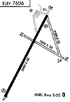
Runways
Runway Summary
| Runways: | 02/20 10/28 16/34 |
| Longest Runway: | 02/20 is 5902 ft (1799 m) long |
| Runways with an Instrument Approach: |
KMVI Airport Runway Details
| Runway 02/20 | 5902 ft x 60 ft (1799 m x 18 m) | |
| Runway Length Source: | 3RD PARTY SURVEY as of 03/25/2020 | |
| Surface: | Asphalt - Fair condition - No special surface treatment | |
| Runway Edge Lights: | Medium Intensity | |
Runway Weight Bearing Capacity (in thousands of pounds) |
||
| Single Wheel Landing Gear: | 12.5 | |
Runway 02 |
Runway 20 |
|
Elevation: |
7611.1 | 7609.6 |
Latitude: |
37-31-12.7155N | 37-32-03.9285N |
Longitude: |
106-03-10.8217W | 106-02-35.7576W |
|
Runway True Alignment: |
029 | 209 |
Glide Path Angle: |
3.0 degrees | 3.0 degrees |
Traffic Pattern: |
Left | Left |
Runway Markings Type: |
Nonprecision Instrument | Nonprecision Instrument |
Runway Markings Condition: |
Fair | Fair |
Object at End: |
PLINE | |
Object Height: |
29 | |
Distance from End: |
1085 | |
Object Centerline Offset: |
0 ft. left and right of centerline | 333 ft. right of centerline |
Visual Glide Slope Indicators: |
2-Light PAPI On Left Side Of Runway | 2-Light PAPI On Left Side Of Runway |
Threshold Crossing Height: |
39 | 38 |
| Runway 10/28 | 2100 ft x 50 ft (640 m x 15 m) | |
| Runway Length Source: | 3RD PARTY SURVEY as of 03/25/2020 | |
| Surface: | Asphalt - Fair condition - No special surface treatment | |
Runway 10 |
Runway 28 |
|
Elevation: |
7608.4 | 7606.2 |
Latitude: |
37-31-50.6340N | 37-31-43.2135N |
Longitude: |
106-02-50.2727W | 106-02-25.9342W |
|
Runway True Alignment: |
111 | 291 |
Glide Path Angle: |
0.0 degrees | 0.0 degrees |
Traffic Pattern: |
Left | Left |
Runway Markings Type: |
None | None |
Runway Markings Condition: |
Poor | Poor |
Object at End: |
TREES | |
Object Height: |
47 | |
Distance from End: |
184 | |
Object Centerline Offset: |
0 ft. left and right of centerline | 333 ft. right of centerline |
| Runway 16/34 | 2300 ft x 30 ft (701 m x 9 m) | |
| Runway Length Source: | 3RD PARTY SURVEY as of 03/25/2020 | |
| Surface: | Asphalt - Fair condition - No special surface treatment | |
Runway 16 |
Runway 34 |
|
Elevation: |
7607.6 | 7606.4 |
Latitude: |
37-32-04.3612N | 37-31-42.1924N |
Longitude: |
106-02-34.2128W | 106-02-27.9043W |
|
Runway True Alignment: |
167 | 347 |
Glide Path Angle: |
0.0 degrees | 0.0 degrees |
Runway Markings Type: |
None | None |
Runway Markings Condition: |
Poor | Poor |
Object at End: |
FENCE | |
Object Height: |
8 | |
Distance from End: |
218 | |
Object Centerline Offset: |
0 ft. left and right of centerline | 333 ft. right of centerline |
Services
Airframe Repair: |
Minor |
Powerplant Repair: |
Minor |
Fuel Available: |
100LL |
Landing Fees: |
No |
Parking: |
Tiedowns available |
Other Services: |
Commuter airline |
Maps & Diagrams
KMVI Sectional
Flight Planning
at skyvector.com
at skyvector.com