Location
Latitude: |
35-52-43.1700N (35.878658) |
Longitude: |
086-22-38.8950W (-86.377471) |
Elevation: |
614.1 feet MSL (187 m MSL) |
Magnetic Variation: |
4.4 W (as of April 2024 from WMM2020 model) |
Time Zone: |
UTC -6.0 (Standard Time) UTC -5.0 (Daylight Savings Time) |
From City: |
02 N.M. N of Murfreesboro, Tennessee |
Found On: |
Atlanta Chart |
FAA Region: |
ASO |
Contacts
Manager: |
Publicly owned: |
| RYAN HULSEY 1930 MEMORIAL BLVD. MURFREESBORO, TN 37129 615-217-5048 |
CITY OF MURFREESBORO CITY HALL, 111 W VINE ST. MURFREESBORO, TN 37130 615-893-5210 |
Operations
Airport Status: |
Operational |
Facility Use: |
Public |
Type: |
Airport |
Activation Date: |
07/1952 |
Control tower: |
No |
Attendance (Months/Days/Hours): |
Months/Days/Hours ALL/SUN/0700-1900 |
Boundary ARTCC: |
ZME (Memphis) |
Responsible ARTCC: |
ZME (Memphis) |
Lighting Schedule: |
SS-SR |
Segmented Circle Indicator: |
Yes |
Traffic Pattern Altitude (MSL): |
1614 feet (492 m) |
NOTAMs Facility: |
BNA |
NOTAM-D Service: |
Yes |
International Airport of Entry: |
No |
Customs Landing Rights: |
No |
Military Landing Rights: |
Yes |
Civil/Military Joint Use: |
No |
Based Aircraft
| Single Engine: | 96 |
| Multi Engine: | 23 |
| Jet Engine: | 3 |
| GA Helicopters: | 1 |
Annual Operations (as of 06/30/2022)
| Total Operations: | 87015 | |
| Air Taxi: | 2000 | 2.3% |
| GA Local: | 80000 | 91.9% |
| GA Itinerant: | 5000 | 5.7% |
| Military Aircraft: | 15 | 0.0% |
Communications
| CTAF: | 123.075 |
| Unicom: | 123.075 |
| Approach: | NASHVILLE 118.4 118.4 |
| Departure: | NASHVILLE 118.4 118.4 |
| AWOS-3: | 133.975 (615-849-2622) |
Fixed Based Operators (FBOs) & Fuel
(Click on a business for detail)
Please help us keep this information up to date. This is a FREE SERVICE just like everything else on Airport Guide! If you see that a business needs to be added, modified, or deleted please fill out our Update Form.
To add, modify, or delete a business click here.
Please help us keep this information up to date. This is a FREE SERVICE just like everything else on Airport Guide! If you see that a business needs to be added, modified, or deleted please fill out our Update Form.
Area Code: 615 |
| Business Name | Frequency | Phone | Fuel Grade |
|---|---|---|---|
| Murfreesboro Municipal
Update FBO info |
848-3254 | 100LL, Jet A |
Flight Service Stations
| Primary | Alternate | |
| FSS on Field: | N | |
| FSS Name (ID): | Nashville(BNA) | |
| Frequency: | ||
| Toll Free Phone: | 1-800-WX-BRIEF |
Instrument Procedures / Charts
FAA Terminal Procedures valid from 0901Z 03/21/24 to 0901Z 04/18/24.
There are various types of charts available for an airport. They are listed in the Page Type column. Here is a legend for those types:
APD - Airport Diagram
DP - Departure Procedure Charts
HOT - Hot Spots
IAP - Instrument Approach Procedure Charts
MIN - Minimums
STAR - Standard Terminal Arrival Charts
| Page Type | Page Name | Volume | Action Since Last Cycle |
|---|---|---|---|
| IAP | RNAV (GPS) RWY 18 | SE-1 | |
| IAP | RNAV (GPS) RWY 36 | SE-1 | |
| MIN | TAKEOFF MINIMUMS | SE-1 |
Terminal Procedures are only available for airports in several countries with more being added all the time. If you are looking for a specific country's charts, please send an email to support(at)airportguide.com stating the country name. This will be used to prioritize the implementation.
Navigation Aids (Navaids) near KMBT
| Dist (NM) | ID | Morse Code | Name | Type | Freq | True Hdg | Mag Hdg |
|---|---|---|---|---|---|---|---|
| 5.0 | FQW | . . _ . _ _ . _ . _ _ | Walter Hill | NDB | 371 | 3 | 7 |
| 6.3 | SWZ | . . . . _ _ _ _ . . | Sewart | NDB | 391 | 318 | 322 |
| 10.0 | MQY | _ _ _ _ . _ _ . _ _ | Smyrna | VOT | 110.20 | 320 | 324 |
| 19.1 | JUE | . _ _ _ . . _ . | Lebanon | NDB | 414 | 9 | 13 |
| 19.2 | SYI | . . . _ . _ _ . . | Shelbyville | VOR-DME | 113.55 | 188 | 192 |
| 19.7 | BNA | _ . . . _ . . _ | Nashville Metropoln | VOT | 108.60 | 316 | 320 |
| 21.5 | BNA | _ . . . _ . . _ | Nashville | VORTAC | 114.10 | 316 | 320 |
| 23.6 | VI | . . . _ . . | Opery | NDB | 344 | 325 | 329 |
| 24.1 | SYI | . . . _ . _ _ . . | Bomar | FAN MARKER | 190 | 194 | |
| 25.9 | ULH | . . _ . _ . . . . . . | Burwi | NDB | 332 | 165 | 169 |
| 28.4 | SKN | . . . _ . _ _ . | Hurricane | NDB | 256 | 76 | 81 |
| 30.6 | UXM | . . _ _ . . _ _ _ | Tullahoma Regional | VOR | 109.65 | 167 | 171 |
| 30.8 | RN | . _ . _ . | Warri | NDB | 209 | 104 | 109 |
| 31.0 | LUG | . _ . . . . _ _ _ . | Verona | NDB | 251 | 222 | 226 |
| 38.4 | PBC | . _ _ . _ . . . _ . _ . | Maury County | NDB | 365 | 245 | 249 |
| 39.0 | HEM | . . . . . _ _ | Huchn | NDB | 233 | 80 | 85 |
| 44.7 | BGF | _ . . . _ _ . . . _ . | Boiling Fork | NDB | 263 | 160 | 164 |
| 45.4 | TNY | _ _ . _ . _ _ | Kelso | NDB | 358 | 190 | 194 |
| 45.6 | ON | _ _ _ _ . | Music | NDB | 279 | 320 | 324 |
| 52.3 | GHM | _ _ . . . . . _ _ | Graham | DME | 111.6 | 267 | 271 |
Nearby Airports with Fuel
Notices to Airmen (NOTAMS)
Remarks
| A110-1 | STUDENT FLT TRNG 0800-1700. |
| A110-100 | GCO AVBL ON FREQ 135.075 THRU NASHVILLE CD. IF UNA FOR CD CTC NASHVILLE APCH 615-695-4522. |
| A110-103 | WILDLIFE INVOF ARPT. |
| A110-104 | ENGINE RUN-UP CONDUCTED E SIDE OF MAIN RAMP. |
| A110-105 | TRNG PAT CLSD 2200-0700 MON-FRI; WKEND & HOL 2200-0800; OTR TIMES PPR - AMGR. |
| A110-106 | NOISE ABATEMENT PROC IN EFCT; DEP CMB 2000 FT MSL BFR TURN. |
| A110-107 | OPDT PRACTICE APCHS NA. |
| A17 | GEN ARPT INFO - 615-848-3254; EMERG OR AFT HR SVC - AMGR. |
| A30A-36 | CALM WIND RWY. |
Runways
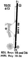
Runway Summary
| Runways: | 18/36 |
| Longest Runway: | 18/36 is 4753 ft (1449 m) long |
| Runways with an Instrument Approach: |
KMBT Airport Runway Details
| Runway 18/36 | 4753 ft x 100 ft (1449 m x 30 m) | |
| Runway Length Source: | OWNER as of 06/17/2005 | |
| Surface: | Asphalt - Good condition - No special surface treatment | |
| Runway Edge Lights: | Medium Intensity | |
Runway Weight Bearing Capacity (in thousands of pounds) |
||
| Single Wheel Landing Gear: | 30.0 | |
Runway 18 |
Runway 36 |
|
Elevation: |
600.0 | 613.6 |
Latitude: |
35-53-06.6500N | 35-52-19.6900N |
Longitude: |
086-22-37.6600W | 086-22-40.1300W |
|
Runway True Alignment: |
182 | 002 |
Glide Path Angle: |
3.0 degrees | 3.8 degrees |
Traffic Pattern: |
Left | Left |
Runway Markings Type: |
Nonprecision Instrument | Nonprecision Instrument |
Runway Markings Condition: |
Good | Good |
Object at End: |
TREE | TREE |
Object Height: |
61 | 62 |
Distance from End: |
1984 | 1281 |
Object Centerline Offset: |
271 ft. right of centerline | 118 ft. right of centerline |
Visual Glide Slope Indicators: |
2-Light PAPI On Left Side Of Runway | 2-Light PAPI On Left Side Of Runway |
REIL: |
Yes | Yes |
Threshold Crossing Height: |
18 | 25 |
Services
Airframe Repair: |
Major |
Powerplant Repair: |
Major |
Fuel Available: |
100LL, Jet A |
Landing Fees: |
No |
Parking: |
Hangars and tiedowns available |
Maps & Diagrams
KMBT Sectional
Flight Planning
at skyvector.com
at skyvector.com