Location
Latitude: |
48-46-07.9870N (48.768885) |
Longitude: |
101-32-15.5120W (-101.537642) |
Elevation: |
1650.2 feet MSL (503 m MSL) |
Magnetic Variation: |
6.2 E (as of April 2024 from WMM2020 model) |
Time Zone: |
UTC -6.0 (Standard Time) UTC -5.0 (Daylight Savings Time) |
From City: |
01 N.M. W of Mohall, North Dakota |
Found On: |
Billings Chart |
FAA Region: |
AGL |
Contacts
Manager: |
Publicly owned: |
| MIKE NEHRING PO BOX 241 MOHALL, ND 58761 701-263-1008 |
CITY OF MOHALL P.O. BOX 476 MOHALL, ND 58761 701-756-6464 |
Operations
Airport Status: |
Operational |
Facility Use: |
Public |
Type: |
Airport |
Activation Date: |
12/1944 |
Control tower: |
No |
Attendance (Months/Days/Hours): |
Months/Days/Hours ALL/ALL/ON CALL |
Boundary ARTCC: |
ZMP (Minneapolis) |
Responsible ARTCC: |
ZMP (Minneapolis) |
Lighting Schedule: |
SEE RMK |
Segmented Circle Indicator: |
Yes |
Traffic Pattern Altitude (MSL): |
2650 feet (808 m) |
NOTAMs Facility: |
GFK |
NOTAM-D Service: |
Yes |
International Airport of Entry: |
No |
Customs Landing Rights: |
No |
Military Landing Rights: |
Yes |
Civil/Military Joint Use: |
No |
Based Aircraft
| Single Engine: | 28 |
| Multi Engine: | 1 |
| GA Helicopters: | 1 |
Annual Operations (as of 04/08/2021)
| Total Operations: | 8720 | |
| Air Taxi: | 20 | 0.2% |
| GA Local: | 7200 | 82.6% |
| GA Itinerant: | 1400 | 16.1% |
| Military Aircraft: | 100 | 1.1% |
Communications
| CTAF: | 122.800 |
| Unicom: | 122.800 |
| Approach: | MINOT 119.6 119.6 MINNEAPOLIS ARTCC |
| Departure: | MINOT 119.6 119.6 MINNEAPOLIS ARTCC |
- APCH/DEP SVC PRVDD BY MINNEAPOLIS ARTCC ON FREQS 127.6/279.6 (MINOT RCAG) WHEN MINOT APCH CTL CLSD.
Fixed Based Operators (FBOs) & Fuel
(Click on a business for detail)
Please help us keep this information up to date. This is a FREE SERVICE just like everything else on Airport Guide! If you see that a business needs to be added, modified, or deleted please fill out our Update Form.
To add, modify, or delete a business click here.
Please help us keep this information up to date. This is a FREE SERVICE just like everything else on Airport Guide! If you see that a business needs to be added, modified, or deleted please fill out our Update Form.
Area Code: 701 |
| Business Name | Frequency | Phone | Fuel Grade |
|---|---|---|---|
| Hett's Agri Service
Update FBO info |
Unicom 122.8 | 756-7177 | 100LL |
Flight Service Stations
| Primary | Alternate | |
| FSS on Field: | N | |
| FSS Name (ID): | Grand Forks(GFK) | |
| Frequency: | ||
| Toll Free Phone: | 1-800-WX-BRIEF |
Instrument Procedures / Charts
FAA Terminal Procedures valid from 0901Z 03/21/24 to 0901Z 04/18/24.
There are various types of charts available for an airport. They are listed in the Page Type column. Here is a legend for those types:
APD - Airport Diagram
DP - Departure Procedure Charts
HOT - Hot Spots
IAP - Instrument Approach Procedure Charts
MIN - Minimums
STAR - Standard Terminal Arrival Charts
| Page Type | Page Name | Volume | Action Since Last Cycle |
|---|---|---|---|
| IAP | RNAV (GPS) RWY 13 | NC-1 | |
| IAP | RNAV (GPS) RWY 31 | NC-1 | |
| MIN | TAKEOFF MINIMUMS | NC-1 |
Terminal Procedures are only available for airports in several countries with more being added all the time. If you are looking for a specific country's charts, please send an email to support(at)airportguide.com stating the country name. This will be used to prioritize the implementation.
Navigation Aids (Navaids) near KHBC
| Dist (NM) | ID | Morse Code | Name | Type | Freq | True Hdg | Mag Hdg |
|---|---|---|---|---|---|---|---|
| 22.3 | MIB | _ _ . . _ . . . | Deering | TACAN | 114.90 | 162 | 156 |
| 32.1 | MOT | _ _ _ _ _ _ | Minot | VOR-DME | 117.10 | 161 | 155 |
| 58.4 | L7 | Estevan | NDB | 395 | 297 | 290 | |
| 60.1 | 8A | Carlyle | NDB | 310 | 331 | 325 | |
| 87.7 | SF | . . . . . _ . | Yuson | NDB | 275 | 244 | 237 |
| 89.2 | BR | Brandon | NDB | 233 | 39 | 33 | |
| 89.6 | ISN | . . . . . _ . | Williston | NDB | 275 | 246 | 239 |
| 92.5 | YBR | _ . _ _ _ . . . . _ . | Brandon | VORTAC | 113.80 | 41 | 35 |
| 93.2 | ISN | . . . . . _ . | Williston | VOR-DME | 116.30 | 251 | 244 |
Nearby Airports with Fuel
| Dist (NM) | Name (Airport IDs) | True Hdg | Mag Hdg | Fuel Grade |
|---|---|---|---|---|
| 21.1 | Kenmare Municipal Airport (7K5) |
253 | 246 | 100LL |
| 32.4 | Minot International Airport (MOT KMOT MOT) |
161 | 155 | 100LL, Jet A |
| 44.4 | Bottineau Municipal Airport (D09) |
84 | 79 | 100LL |
| 44.5 | Stanley Municipal Airport (08D) |
231 | 224 | 100LL, Jet A+, MOGAS |
| 55.5 | Parshall-Hankins Airport (Y74) |
205 | 198 | 100LL |
| 58.8 | Tioga Municipal Airport (VEX D60) |
247 | 240 | 100LL, Jet A |
| 64.2 | Rugby Municipal Airport (KRUG RUG) |
110 | 105 | 100LL, Jet A |
| 67.0 | Rolette Airport (2H9) |
94 | 89 | 100lL |
| 76.0 | Rolla Municipal/Leonard Krech Field Airport (06D) |
84 | 79 | 100LL, Jet A |
| 86.9 | Harvey Municipal Airport (5H4) |
131 | 126 | 100LL |
| 87.5 | Washburn Municipal Airport (5C8) |
166 | 160 | 100LL |
| 88.8 | Mercer County Regional Airport (KHZE HZE) |
181 | 175 | 100LL, Jet A |
| 92.4 | Brandon Municipal Airport (YBR CYBR CYBR) |
41 | 36 | 100LL, Jet A |
Notices to Airmen (NOTAMS)
Remarks
| A110-1 | +185' TV TWR 5000' FM ARPT LCTD ON SOUTH EDGE OF TOWN. |
| A110-2 | TO CONFIRM SNOW REMOVAL & WINTER CONDS, CALL - 701-263-1008 OR 701-263-1243. |
| A110-3 | RWY 13 5 FT SWALE 200 FT OUTBOUND THLD. |
| A110-4 | FOR CD CTC MINNEAPOLIS ARTCC AT 651-463-5588. |
| A14 | ADDTL CTC GARY ALBRIGHT 701-240-5536. |
| A16 | AMGR ADDTL PHONE 701-756-6364 OR 701-756-7258. |
| A52-13 | 50 FT PLINE 2550 FT FM THLD ON CNTRLN EXTDD; APCH RATIO 34:1. |
| A70-FUEL-10 | 0LL H24 SELF SVC WITH CREDIT CARD OR CALL AMGR CELL 701-263-1008. |
| A70-FUEL-A | H24 SELF SVC WITH CREDIT CARD OR CALL AMGR CELL 701-263-1008. |
| A81-APT | ACTVT PAPI RWY 13 & 31; MIRL RWY 13/31 - CTAF. |
Runways
Runway Summary
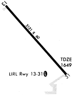
| Runways: | 13/31 |
| Longest Runway: | 13/31 is 3121 ft (951 m) long |
| Runways with an Instrument Approach: |
KHBC Airport Runway Details
| Runway 13/31 | 3121 ft x 60 ft (951 m x 18 m) | |
| Runway Edge Lights: | Yes Intensity | |
Runway 13 |
Runway 31 |
|
Elevation: |
1645 | 1647 |
Latitude: |
48.77159881591 | 48.76509857177 |
Longitude: |
-101.5410003662 | -101.5329971313 |
|
Runway True Alignment: |
140 | 320 |
Glide Path Angle: |
0.0 degrees | 0.0 degrees |
REIL: |
Yes | Yes |
Threshold Elevation: |
1645 | 1647 |
Services
Fuel Available: |
100LL, Jet A |
Maps & Diagrams
KHBC Sectional
Flight Planning
at skyvector.com
at skyvector.com