Location
Latitude: |
31-28-36.2590N (31.476739) |
Longitude: |
082-51-38.0410W (-82.860567) |
Elevation: |
256.5 feet MSL (78 m MSL) |
Magnetic Variation: |
6.2 W (as of April 2024 from WMM2020 model) |
Time Zone: |
UTC -5.0 (Standard Time) UTC -4.0 (Daylight Savings Time) |
From City: |
02 N.M. S of Douglas, Georgia |
Found On: |
Jacksonville Chart |
FAA Region: |
ASO |
Contacts
Manager: |
Publicly owned: |
| DANIEL BEAUCHAMP CITY OF DOUGLAS PO BOX 470 DOUGLAS, GA 31534 912-384-1409 |
CITY OF DOUGLAS PO BOX 470 DOUGLAS, GA 31534 912-389-3401 |
Operations
Airport Status: |
Operational |
Facility Use: |
Public |
Type: |
Airport |
Activation Date: |
04/1940 |
Control tower: |
No |
Attendance (Months/Days/Hours): |
Months/Days/Hours ALL/M-F/0800-1700 |
Boundary ARTCC: |
ZJX (Jacksonville) |
Responsible ARTCC: |
ZJX (Jacksonville) |
Lighting Schedule: |
SEE RMK |
Segmented Circle Indicator: |
Yes |
Traffic Pattern Altitude (MSL): |
1256 feet (383 m) |
NOTAMs Facility: |
MCN |
NOTAM-D Service: |
Yes |
International Airport of Entry: |
No |
Customs Landing Rights: |
No |
Military Landing Rights: |
Yes |
Civil/Military Joint Use: |
No |
Based Aircraft
| Single Engine: | 51 |
| Multi Engine: | 7 |
| GA Helicopters: | 3 |
Annual Operations (as of 12/31/2023)
| Total Operations: | 12000 | |
| GA Local: | 9000 | 75.0% |
| GA Itinerant: | 3000 | 25.0% |
Communications
| CTAF: | 122.800 |
| Unicom: | 122.800 |
| AWOS-3: | 119.075 (912-383-7258) |
- APCH/DEP SVC PRVDD BY JACKSONVILLE ARTCC ON FREQS 127.575/269.025 (ALMA RCAG).
Fixed Based Operators (FBOs) & Fuel
(Click on a business for detail)
Please help us keep this information up to date. This is a FREE SERVICE just like everything else on Airport Guide! If you see that a business needs to be added, modified, or deleted please fill out our Update Form.
To add, modify, or delete a business click here.
Please help us keep this information up to date. This is a FREE SERVICE just like everything else on Airport Guide! If you see that a business needs to be added, modified, or deleted please fill out our Update Form.
Area Code: 912 |
| Business Name | Frequency | Phone | Fuel Grade |
|---|---|---|---|
| Harless Aviation
Update FBO info |
384-5513 | 100LL, Jet A |
Flight Service Stations
| Primary | Alternate | |
| FSS on Field: | N | |
| FSS Name (ID): | Macon(MCN) | |
| Frequency: | ||
| Toll Free Phone: | 1-800-WX-BRIEF |
Instrument Procedures / Charts
FAA Terminal Procedures valid from 0901Z 03/21/24 to 0901Z 04/18/24.
There are various types of charts available for an airport. They are listed in the Page Type column. Here is a legend for those types:
APD - Airport Diagram
DP - Departure Procedure Charts
HOT - Hot Spots
IAP - Instrument Approach Procedure Charts
MIN - Minimums
STAR - Standard Terminal Arrival Charts
| Page Type | Page Name | Volume | Action Since Last Cycle |
|---|---|---|---|
| IAP | ILS OR LOC RWY 04 | SE-4 | |
| IAP | RNAV (GPS) RWY 04 | SE-4 | |
| IAP | RNAV (GPS) RWY 22 | SE-4 | |
| MIN | ALTERNATE MINIMUMS | SE-4 | |
| MIN | TAKEOFF MINIMUMS | SE-4 |
Terminal Procedures are only available for airports in several countries with more being added all the time. If you are looking for a specific country's charts, please send an email to support(at)airportguide.com stating the country name. This will be used to prioritize the implementation.
Navigation Aids (Navaids) near KDQH
| Dist (NM) | ID | Morse Code | Name | Type | Freq | True Hdg | Mag Hdg |
|---|---|---|---|---|---|---|---|
| 5.4 | OWC | _ _ _ . _ _ _ . _ . | Coffee County | NDB | 390 | 216 | 222 |
| 18.4 | AMG | . _ _ _ _ _ . | Alma | VORTAC | 115.10 | 78 | 84 |
| 19.9 | AYS | . _ _ . _ _ . . . | Waycross | VORTAC | 110.20 | 128 | 134 |
| 23.5 | SUR | . . . . . _ . _ . | Fitzgerald | NDB | 362 | 290 | 296 |
| 25.4 | AY | . _ _ . _ _ | Wiket | NDB | 219 | 110 | 116 |
| 25.7 | HOE | . . . . _ _ _ . | Homerville | NDB | 209 | 169 | 175 |
| 26.5 | AZE | . _ _ _ . . . | Hazlehurst | NDB | 414 | 24 | 30 |
| 27.9 | BHC | _ . . . . . . . _ . _ . | Baxley | NDB | 376 | 59 | 65 |
| 30.6 | TM | _ _ _ | Tifto | NDB | 409 | 257 | 263 |
| 32.3 | IFM | . . . . _ . _ _ | Tift Myers | VOR | 112.50 | 265 | 271 |
| 35.4 | VAD | . . . _ . _ _ . . | Moody | TACAN | 113.30 | 208 | 214 |
| 37.2 | MQW | _ _ _ _ . _ . _ _ | Mc Rae | NDB | 280 | 358 | 364 |
| 42.0 | EZM | . _ _ . . _ _ | Eastman | NDB | 366 | 339 | 345 |
| 47.0 | OTK | _ _ _ _ _ . _ | Valdosta | VOR-DME | 114.80 | 207 | 213 |
| 50.0 | JES | . _ _ _ . . . . | Slover | NDB | 340 | 84 | 91 |
| 50.2 | RVJ | . _ . . . . _ . _ _ _ | Prison | NDB | 424 | 45 | 52 |
| 53.2 | UQN | . . _ _ _ . _ _ . | Onyun | NDB | 372 | 32 | 38 |
| 53.9 | MGR | _ _ _ _ . . _ . | Moultrie | DME | 108.8 | 244 | 250 |
| 54.8 | VNA | . . . _ _ . . _ | Vienna | VORTAC | 116.50 | 323 | 329 |
| 58.5 | GTP | _ _ . _ . _ _ . | Paton | NDB | 245 | 238 | 244 |
Nearby Airports with Fuel
Notices to Airmen (NOTAMS)
Remarks
| A110-2 | FOR CD CTC JACKSONVILLE ARTCC AT 904-845-1592. |
| A81-APT | ACTVT MALSR RWY 04; PAPI RWY 04 & 22; MIRL RWY 04/22 - CTAF. |
| E111 | EXISTED PRIOR TO 1959. |
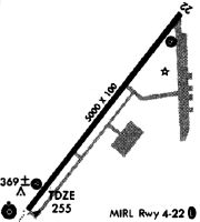
Runways
Runway Summary
| Runways: | 04/22 |
| Longest Runway: | 04/22 is 6000 ft (1829 m) long |
| Runways with an Instrument Approach: | 04 |
KDQH Airport Runway Details
| Runway 04/22 | 6000 ft x 100 ft (1829 m x 30 m) | |
| Runway Length Source: | 3RD PARTY SURVEY as of 11/16/2008 | |
| Surface: | Asphalt - Good condition - No special surface treatment | |
| Runway Pavement Class: | 27 /F/C/X/T | |
| Runway Edge Lights: | Medium Intensity | |
Runway Weight Bearing Capacity (in thousands of pounds) |
||
| Single Wheel Landing Gear: | 26.0 | |
Runway 04 |
Runway 22 |
|
Elevation: |
249.7 | 255.8 |
Latitude: |
31-28-12.6254N | 31-28-59.8916N |
Longitude: |
082-51-59.0061W | 082-51-17.0721W |
|
Runway True Alignment: |
037 | 217 |
ILS Type: |
LOC/GS | |
Glide Path Angle: |
3.0 degrees | 2.5 degrees |
Traffic Pattern: |
Left | Left |
Runway Markings Type: |
Precision Instrument | Precision Instrument |
Runway Markings Condition: |
Fair | Fair |
Object at End: |
TREES | TREES |
Object Height: |
57 | 52 |
Distance from End: |
2765 | 1292 |
Object Centerline Offset: |
877 ft. right of centerline | 600 ft. left of centerline |
Visual Glide Slope Indicators: |
2-Light PAPI On Left Side Of Runway | 2-Light PAPI On Left Side Of Runway |
Approach Light System: |
1,400 Foot Medium Intensity Approach Lighting System With Runway Alignment Indicator Lights | |
Threshold Crossing Height: |
52 | 27 |
Services
Airframe Repair: |
Major |
Powerplant Repair: |
Minor |
Bottled Oxygen: |
None |
Bulk Oxygen: |
None |
Fuel Available: |
100LL, Jet A+ |
Landing Fees: |
No |
Parking: |
Tiedowns available |
Maps & Diagrams
KDQH Sectional
Flight Planning
at skyvector.com
at skyvector.com