Location
Latitude: |
41-56-01.8033N (41.933834) |
Longitude: |
088-42-20.4710W (-88.705686) |
Elevation: |
912.6 feet MSL (278 m MSL) |
Magnetic Variation: |
3.3 W (as of April 2024 from WMM2020 model) |
Time Zone: |
UTC -6.0 (Standard Time) UTC -5.0 (Daylight Savings Time) |
From City: |
02 N.M. E of De Kalb, Illinois |
Found On: |
Chicago Chart |
FAA Region: |
AGL |
Contacts
Manager: |
Publicly owned: |
| BENJAMIN TROMPETER 3232 PLEASANT STREET DEKALB, IL 60115 815-748-8102 |
CITY OF DEKALB 164 EAST LINCOLN HWY DEKALB, IL 60115 815-748-2000 |
Operations
Airport Status: |
Operational |
Facility Use: |
Public |
Type: |
Airport |
Activation Date: |
04/1944 |
Control tower: |
No |
Attendance (Months/Days/Hours): |
Months/Days/Hours NOV-FEB/ALL/0800-1600 |
Boundary ARTCC: |
ZAU (Chicago) |
Responsible ARTCC: |
ZAU (Chicago) |
Lighting Schedule: |
SEE RMK |
Segmented Circle Indicator: |
No |
Traffic Pattern Altitude (MSL): |
1913 feet (583 m) |
NOTAMs Facility: |
DKB |
NOTAM-D Service: |
Yes |
International Airport of Entry: |
No |
Customs Landing Rights: |
No |
Military Landing Rights: |
Yes |
Civil/Military Joint Use: |
No |
Based Aircraft
| Single Engine: | 69 |
| Multi Engine: | 6 |
| GA Helicopters: | 2 |
Annual Operations (as of 02/28/2021)
| Total Operations: | 27000 | |
| Air Taxi: | 1080 | 4.0% |
| GA Local: | 6220 | 23.0% |
| GA Itinerant: | 19700 | 73.0% |
Communications
| CTAF: | 122.700 |
| Unicom: | 122.700 |
| Approach: | CHICAGO 133.5 133.5 |
| Departure: | CHICAGO 133.5 133.5 |
| AWOS-3: | 119.075 (815-748-2350) |
Fixed Based Operators (FBOs) & Fuel
(Click on a business for detail)
Please help us keep this information up to date. This is a FREE SERVICE just like everything else on Airport Guide! If you see that a business needs to be added, modified, or deleted please fill out our Update Form.
To add, modify, or delete a business click here.
Please help us keep this information up to date. This is a FREE SERVICE just like everything else on Airport Guide! If you see that a business needs to be added, modified, or deleted please fill out our Update Form.
Area Code: 815 |
| Business Name | Frequency | Phone | Fuel Grade |
|---|---|---|---|
| DeKalb Flight Center
Website Update FBO info |
122.8 unicom 119.075 AWOS-3 | 847-758-3521 | 100LL, Jet A |

|
Phillips | 100LL - 4.25 USD per gallon on 4/28/2021 |
24 Hour Self-Serve Credit Card Pumps Self Serve |
|
|
Phillips | 100LL - 4.65 USD per gallon on 4/28/2021 |
Pumps Full Serve |
|
|
Phillips | Jet A - 3.69 USD per gallon on 4/28/2021 |
Truck with Prist |
Flight Service Stations
| Primary | Alternate | |
| FSS on Field: | N | |
| FSS Name (ID): | Kankakee(IKK) | |
| Frequency: | ||
| Toll Free Phone: | 1-800-WX-BRIEF |
Instrument Procedures / Charts
FAA Terminal Procedures valid from 0901Z 03/21/24 to 0901Z 04/18/24.
There are various types of charts available for an airport. They are listed in the Page Type column. Here is a legend for those types:
APD - Airport Diagram
DP - Departure Procedure Charts
HOT - Hot Spots
IAP - Instrument Approach Procedure Charts
MIN - Minimums
STAR - Standard Terminal Arrival Charts
| Page Type | Page Name | Volume | Action Since Last Cycle |
|---|---|---|---|
| IAP | ILS OR LOC RWY 02 | EC-3 | |
| IAP | RNAV (GPS) RWY 02 | EC-3 | |
| IAP | RNAV (GPS) RWY 09 | EC-3 | |
| IAP | RNAV (GPS) RWY 20 | EC-3 | |
| IAP | RNAV (GPS) RWY 27 | EC-3 | |
| MIN | ALTERNATE MINIMUMS | EC-3 | |
| MIN | TAKEOFF MINIMUMS | EC-3 |
Terminal Procedures are only available for airports in several countries with more being added all the time. If you are looking for a specific country's charts, please send an email to support(at)airportguide.com stating the country name. This will be used to prioritize the implementation.
Navigation Aids (Navaids) near KDKB
| Dist (NM) | ID | Morse Code | Name | Type | Freq | True Hdg | Mag Hdg |
|---|---|---|---|---|---|---|---|
| 16.1 | DPA | _ . . . _ _ . . _ | Dupage | VOR-DME | 108.40 | 99 | 102 |
| 20.6 | RF | . _ . . . _ . | Gilmy | NDB | 275 | 301 | 304 |
| 28.1 | RFD | . _ . . . _ . _ . . | Rockford | DME | 110.8 | 308 | 311 |
| 29.0 | JOT | . _ _ _ _ _ _ _ | Joliet | VOR-DME | 112.30 | 143 | 146 |
| 30.4 | ME | _ _ . | Deana | NDB | 350 | 85 | 89 |
| 34.9 | OIX | _ _ _ . . _ . . _ | Ottawa | NDB | 266 | 191 | 194 |
| 35.9 | ORD | _ _ _ . _ . _ . . | Chicago O'hare | VOR-DME | 113.90 | 84 | 88 |
| 36.0 | GCO | _ _ . _ . _ . _ _ _ | Chicago | DME | 108.25 | 83 | 87 |
| 36.6 | PLL | . _ _ . . _ . . . _ . . | Polo | VOR-DME | 111.20 | 273 | 276 |
| 37.8 | OBK | _ _ _ _ . . . _ . _ | Northbrook | VOR-DME | 113.00 | 62 | 66 |
| 40.9 | HK | . . . . _ . _ | Ermin | NDB | 332 | 108 | 112 |
| 41.4 | JVL | . _ _ _ . . . _ . _ . . | Janesville | VOR-DME | 114.30 | 334 | 337 |
| 43.5 | JVL | . _ _ _ . . . _ . _ . . | Janesville | NDB | 375 | 340 | 343 |
| 43.5 | MDW | _ _ _ . . . _ _ | Chicago Midway | VOT | 111.00 | 101 | 105 |
| 46.2 | LVV | . _ . . . . . _ . . . _ | Lake Lawn | NDB | 404 | 6 | 9 |
| 46.9 | MX | _ _ _ . . _ | Kedzi | NDB | 248 | 103 | 107 |
| 48.1 | EN | . _ . | Codee | NDB | 389 | 38 | 42 |
| 48.7 | BUU | _ . . . . . _ . . _ | Burbun | DME | 114.5 | 21 | 25 |
| 50.1 | BOZ | _ . . . _ _ _ _ _ . . | Whiteside | NDB | 254 | 254 | 257 |
| 51.3 | UG | . . _ _ _ . | Wauke | NDB | 379 | 51 | 55 |
Nearby Airports with Fuel
Notices to Airmen (NOTAMS)
Remarks
| A110-2 | FOR CD CTC CHICAGO APCH AT 847-289-0926. |
| A81-APT | MIRL RWY 02/20 PRESET LOW INTST, TO INCR INTST & ACTVT MIRL RWY 09/27, PAPI RWYS 09 & 27, REIL RWYS 09, 27, & 20, AND MALSR RWY 02 - CTAF. PAPI RWYS 02 & 20 OPERATE 24 HRS. |
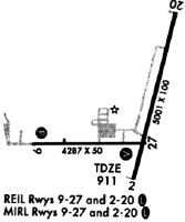
Runways
Runway Summary
| Runways: | 02/20 09/27 |
| Longest Runway: | 02/20 is 7026 ft (2142 m) long |
| Runways with an Instrument Approach: | 02 |
KDKB Airport Runway Details
| Runway 02/20 | 7026 ft x 100 ft (2142 m x 30 m) | |
| Runway Length Source: | STATE as of 09/14/2007 | |
| Surface: | Asphalt - Fair condition - Saw-cut or plastic grooved | |
| Runway Edge Lights: | Medium Intensity | |
Runway Weight Bearing Capacity (in thousands of pounds) |
||
| Single Wheel Landing Gear: | 25.0 | |
| Dual Wheel Landing Gear: | 80.0 | |
Runway 02 |
Runway 20 |
|
Elevation: |
912.6 | 903.7 |
Latitude: |
41-55-39.4759N | 41-56-44.9074N |
Longitude: |
088-42-24.4251W | 088-41-53.3942W |
|
Runway True Alignment: |
019 | 199 |
ILS Type: |
ILS/DME | |
Glide Path Angle: |
3.0 degrees | 3.0 degrees |
Runway Markings Type: |
Precision Instrument | Nonprecision Instrument |
Runway Markings Condition: |
Fair | Fair |
Object at End: |
RR | |
Object Height: |
21 | |
Distance from End: |
1237 | |
Object Centerline Offset: |
650 ft. right of centerline | |
Visual Glide Slope Indicators: |
4-Light PAPI On Left Side Of Runway | 4-Light PAPI On Left Side Of Runway |
Approach Light System: |
1,400 Foot Medium Intensity Approach Lighting System With Runway Alignment Indicator Lights | |
REIL: |
No | Yes |
Threshold Crossing Height: |
53 | 29 |
| Runway 09/27 | 4201 ft x 75 ft (1280 m x 23 m) | |
| Runway Length Source: | NGS as of 10/13/2006 | |
| Surface: | Asphalt - Fair condition - Saw-cut or plastic grooved | |
| Runway Edge Lights: | Medium Intensity | |
Runway Weight Bearing Capacity (in thousands of pounds) |
||
| Single Wheel Landing Gear: | 25.0 | |
| Dual Wheel Landing Gear: | 80.0 | |
Runway 09 |
Runway 27 |
|
Elevation: |
911.4 | 911.7 |
Latitude: |
41-55-44.3858N | 41-55-44.4725N |
Longitude: |
088-43-07.5961W | 088-42-12.0179W |
|
Runway True Alignment: |
090 | 270 |
Glide Path Angle: |
3.0 degrees | 3.0 degrees |
Traffic Pattern: |
Left | Left |
Runway Markings Type: |
Nonprecision Instrument | Nonprecision Instrument |
Runway Markings Condition: |
Fair | Fair |
Object Centerline Offset: |
650 ft. right of centerline | |
Visual Glide Slope Indicators: |
4-Light PAPI On Left Side Of Runway | 4-Light PAPI On Left Side Of Runway |
REIL: |
Yes | Yes |
Threshold Crossing Height: |
30 | 24 |
Services
Airframe Repair: |
None |
Powerplant Repair: |
None |
Bottled Oxygen: |
None |
Bulk Oxygen: |
None |
Fuel Available: |
100LL |
Landing Fees: |
No |
Parking: |
Hangars and tiedowns available |
Maps & Diagrams
KDKB Sectional
Flight Planning
at skyvector.com
at skyvector.com