Location
Latitude: |
40-59-38.8500N (40.994125) |
Longitude: |
094-45-18.1070W (-94.75503) |
Elevation: |
1274.0 feet MSL (388 m MSL) |
Magnetic Variation: |
1.3 E (as of April 2024 from WMM2020 model) |
Time Zone: |
UTC -6.0 (Standard Time) UTC -5.0 (Daylight Savings Time) |
From City: |
01 N.M. W of Corning, Iowa |
Found On: |
Omaha Chart |
FAA Region: |
ACE |
Contacts
Manager: |
Publicly owned: |
| WAYNE PAGE 601 6TH CORNING, IA 50841 515-491-5508 |
CITY OF CORNING 601 6TH CORNING, IA 50841 641-322-4230 |
Operations
Airport Status: |
Operational |
Facility Use: |
Public |
Type: |
Airport |
Activation Date: |
03/1957 |
Control tower: |
No |
Attendance (Months/Days/Hours): |
Months/Days/Hours Unattended |
Boundary ARTCC: |
ZMP (Minneapolis) |
Responsible ARTCC: |
ZMP (Minneapolis) |
Lighting Schedule: |
SEE RMK |
Segmented Circle Indicator: |
No |
Traffic Pattern Altitude (MSL): |
2274 feet (693 m) |
NOTAMs Facility: |
FOD |
NOTAM-D Service: |
Yes |
Civil/Military Joint Use: |
No |
Based Aircraft
| Single Engine: | 8 |
Annual Operations (as of 04/01/2022)
| Total Operations: | 2000 | |
| GA Local: | 1250 | 62.5% |
| GA Itinerant: | 750 | 37.5% |
Communications
| CTAF: | 122.900 |
- APCH/DEP SVC PRVDD BY MINNEAPOLIS ARTCC ON FREQS 119.6/290.4 (OMAHA RCAG).
Fixed Based Operators (FBOs) & Fuel
(Click on a business for detail)
Please help us keep this information up to date. This is a FREE SERVICE just like everything else on Airport Guide! If you see that a business needs to be added, modified, or deleted please fill out our Update Form.
To add, modify, or delete a business click here.
Please help us keep this information up to date. This is a FREE SERVICE just like everything else on Airport Guide! If you see that a business needs to be added, modified, or deleted please fill out our Update Form.
Area Code: 641 |
| Business Name | Frequency | Phone | Fuel Grade |
|---|---|---|---|
| City of Corning
Update FBO info |
322-4444 | 80, 100LL |
Flight Service Stations
| Primary | Alternate | |
| FSS on Field: | N | |
| FSS Name (ID): | Fort Dodge(FOD) | |
| Frequency: | ||
| Toll Free Phone: | 1-800-WX-BRIEF |
Instrument Procedures / Charts
FAA Terminal Procedures valid from 0901Z 03/21/24 to 0901Z 04/18/24.
There are various types of charts available for an airport. They are listed in the Page Type column. Here is a legend for those types:
APD - Airport Diagram
DP - Departure Procedure Charts
HOT - Hot Spots
IAP - Instrument Approach Procedure Charts
MIN - Minimums
STAR - Standard Terminal Arrival Charts
| Page Type | Page Name | Volume | Action Since Last Cycle |
|---|---|---|---|
| IAP | RNAV (GPS) RWY 18 | NC-3 | |
| MIN | TAKEOFF MINIMUMS | NC-3 |
Terminal Procedures are only available for airports in several countries with more being added all the time. If you are looking for a specific country's charts, please send an email to support(at)airportguide.com stating the country name. This will be used to prioritize the implementation.
Navigation Aids (Navaids) near KCRZ
| Dist (NM) | ID | Morse Code | Name | Type | Freq | True Hdg | Mag Hdg |
|---|---|---|---|---|---|---|---|
| 0.2 | CRZ | _ . _ . . _ . _ _ . . | Corning | NDB | 278 | 328 | 327 |
| 18.6 | UNE | . . _ _ . . | Union County | NDB | 379 | 96 | 95 |
| 20.4 | ICL | . . _ . _ . . _ . . | Clarinda | NDB | 353 | 217 | 216 |
| 22.7 | RDK | . _ . _ . . _ . _ | Red Oak | NDB | 230 | 273 | 272 |
| 27.9 | AIO | . _ . . _ _ _ | Atlantic | NDB | 365 | 331 | 330 |
| 33.0 | SDA | . . . _ . . . _ | Shenandoah | NDB | 411 | 244 | 243 |
| 42.3 | ADU | . _ _ . . . . _ | Audubon | NDB | 266 | 350 | 349 |
| 43.0 | LMN | . _ . . _ _ _ . | Lamoni | VOR-DME | 116.70 | 123 | 122 |
| 43.9 | HNR | . . . . _ . . _ . | Harlan | NDB | 272 | 323 | 322 |
| 45.6 | OVR | _ _ _ . . . _ . _ . | Omaha | VORTAC | 116.30 | 283 | 281 |
| 49.9 | EN | . _ . | Rikky | NDB | 426 | 286 | 284 |
| 52.3 | OFF | _ _ _ . . _ . . . _ . | Offutt | TACAN | 111.70 | 278 | 276 |
| 52.5 | PMV | . _ _ . _ _ . . . _ | Plattsmouth | NDB | 329 | 267 | 265 |
| 54.2 | OMA | _ _ _ _ _ . _ | Omaha | VOT | 109.00 | 289 | 287 |
| 55.4 | AFK | . _ . . _ . _ . _ | Nebraska City | NDB | 347 | 245 | 243 |
| 56.6 | DSM | _ . . . . . _ _ | Des Moines | VORTAC | 117.50 | 61 | 60 |
| 58.7 | OM | _ _ _ _ _ | Gerfi | NDB | 320 | 292 | 290 |
| 59.3 | DSM | _ . . . . . _ _ | Des Moines | VOT | 109.20 | 56 | 55 |
| 62.5 | STJ | . . . _ . _ _ _ | St Joseph | VORTAC | 115.50 | 187 | 186 |
| 62.6 | MLE | _ _ . _ . . . | Millard | NDB | 371 | 281 | 279 |
Nearby Airports with Fuel
Notices to Airmen (NOTAMS)
Remarks
| A110*G | THIS AIRPORT HAS BEEN SURVEYED BY THE NATIONAL GEODETIC SURVEY. |
| A110-1 | CTN: SHARP DROP BOTH ENDS RWY 18/36. |
| A110-2 | DEER INVOF ARPT. |
| A110-3 | SNOW REMOVAL OPS DURG WINT MONTHS VIA CITY OF CORNING AT 641-322-4230. AFT HRS CALL 515-491-5508. |
| A110-4 | FOR CD CTC MINNEAPOLIS ARTCC AT 651-463-5588. |
| A70-FUEL-10 | 0LL SELF SERVICE FUEL AVBL 24 HOURS WITH CREDIT CARD |
| A81-APT | ACTVT MIRL RY 18/36 - 122.8. |
| E111 | ESTABLISHED PRIOR TO 1959. |
Runways
Runway Summary
| Runways: | 18/36 |
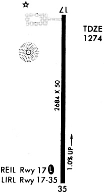
| Longest Runway: | 18/36 is 2684 ft (818 m) long |
| Runways with an Instrument Approach: |
KCRZ Airport Runway Details
| Runway 18/36 | 2684 ft x 50 ft (818 m x 15 m) | |
| Surface: | Concrete - Good condition - No special surface treatment | |
| Runway Edge Lights: | Medium Intensity | |
Runway 18 |
Runway 36 |
|
Elevation: |
1274.0 | 1248.0 |
Latitude: |
40-59-52.1250N | 40-59-25.6120N |
Longitude: |
094-45-17.7920W | 094-45-18.4080W |
|
Runway True Alignment: |
181 | 001 |
Glide Path Angle: |
0.0 degrees | 0.0 degrees |
Traffic Pattern: |
Right | Left |
Runway Markings Type: |
Nonprecision Instrument | Nonprecision Instrument |
Runway Markings Condition: |
Fair | Fair |
Object at End: |
TREE | |
Object Height: |
40 | |
Distance from End: |
1074 | |
Object Centerline Offset: |
194 ft. right of centerline | |
REIL: |
No |
Services
Airframe Repair: |
None |
Powerplant Repair: |
None |
Bottled Oxygen: |
None |
Bulk Oxygen: |
None |
Fuel Available: |
100LL |
Landing Fees: |
No |
Parking: |
Tiedowns available |
Other Services: |
Parachute rental |
Maps & Diagrams
KCRZ Sectional
Flight Planning
at skyvector.com
at skyvector.com