Location
Latitude: |
36-50-31.6940N (36.842137) |
Longitude: |
089-21-34.7680W (-89.359658) |
Elevation: |
313.0 feet MSL (95 m MSL) |
Magnetic Variation: |
2.4 W (as of April 2024 from WMM2020 model) |
Time Zone: |
UTC -6.0 (Standard Time) UTC -5.0 (Daylight Savings Time) |
From City: |
04 N.M. S of Charleston, Missouri |
Found On: |
St Louis Chart |
FAA Region: |
ACE |
Contacts
Manager: |
Publicly owned: |
| MISSISSIPPI COUNTY COMMISSION PO BOX 369 CHARLESTON, MO 63834 573-683-2146 |
MISSISSIPPI COUNTY COMMISSION PO BOX 369 CHARLESTON, MO 63834 573-683-2146 |
Operations
Airport Status: |
Operational |
Facility Use: |
Public |
Type: |
Airport |
Activation Date: |
10/1975 |
Control tower: |
No |
Attendance (Months/Days/Hours): |
Months/Days/Hours IREG |
Boundary ARTCC: |
ZME (Memphis) |
Responsible ARTCC: |
ZME (Memphis) |
Lighting Schedule: |
SEE RMK |
Segmented Circle Indicator: |
Yes |
Traffic Pattern Altitude (MSL): |
1313 feet (400 m) |
NOTAMs Facility: |
STL |
NOTAM-D Service: |
Yes |
International Airport of Entry: |
No |
Customs Landing Rights: |
No |
Military Landing Rights: |
Yes |
Civil/Military Joint Use: |
No |
Based Aircraft
Annual Operations (as of 12/31/2020)
| Total Operations: | 1215 | |
| GA Local: | 900 | 74.1% |
| GA Itinerant: | 300 | 24.7% |
| Military Aircraft: | 15 | 1.2% |
Communications
| CTAF: | 122.900 |
- APCH/DEP SVC PRVDD BY MEMPHIS ARTCC ON FREQS 133.65/292.15 (PADUCAH RCAG).
Fixed Based Operators (FBOs) & Fuel
(Click on a business for detail)
Please help us keep this information up to date. This is a FREE SERVICE just like everything else on Airport Guide! If you see that a business needs to be added, modified, or deleted please fill out our Update Form.
To add, modify, or delete a business click here.
Please help us keep this information up to date. This is a FREE SERVICE just like everything else on Airport Guide! If you see that a business needs to be added, modified, or deleted please fill out our Update Form.
Area Code: 573 |
| Business Name | Frequency | Phone | Fuel Grade |
|---|
Flight Service Stations
| Primary | Alternate | |
| FSS on Field: | N | |
| FSS Name (ID): | Saint Louis(STL) | |
| Frequency: | ||
| Toll Free Phone: | 1-800-WX-BRIEF |
Instrument Procedures / Charts
FAA Terminal Procedures valid from 0901Z 03/21/24 to 0901Z 04/18/24.
There are various types of charts available for an airport. They are listed in the Page Type column. Here is a legend for those types:
APD - Airport Diagram
DP - Departure Procedure Charts
HOT - Hot Spots
IAP - Instrument Approach Procedure Charts
MIN - Minimums
STAR - Standard Terminal Arrival Charts
| Page Type | Page Name | Volume | Action Since Last Cycle |
|---|---|---|---|
| IAP | RNAV (GPS) RWY 18 | NC-3 | |
| IAP | RNAV (GPS) RWY 36 | NC-3 | |
| MIN | TAKEOFF MINIMUMS | NC-3 |
Terminal Procedures are only available for airports in several countries with more being added all the time. If you are looking for a specific country's charts, please send an email to support(at)airportguide.com stating the country name. This will be used to prioritize the implementation.
Navigation Aids (Navaids) near KCHQ
| Dist (NM) | ID | Morse Code | Name | Type | Freq | True Hdg | Mag Hdg |
|---|---|---|---|---|---|---|---|
| 0.2 | CHQ | _ . _ . . . . . _ _ . _ | Charleston | NDB | 208 | 38 | 40 |
| 14.7 | CIR | _ . _ . . . . _ . | Cairo | NDB | 397 | 26 | 28 |
| 25.3 | CGI | _ . _ . _ _ . . . | Cape Girardeau | DME | 112.9 | 336 | 338 |
| 27.0 | CNG | _ . _ . _ . _ _ . | Cunningham | VOR-DME | 113.10 | 68 | 71 |
| 29.6 | CG | _ . _ . _ _ . | Dutch | NDB | 248 | 326 | 328 |
| 31.6 | MAW | _ _ . _ . _ _ | Malden | TACAN | 111.20 | 237 | 239 |
| 37.1 | UC | . . _ _ . _ . | Obion | NDB | 212 | 151 | 154 |
| 37.7 | BDD | _ . . . _ . . _ . . | Bellgrade | NDB | 254 | 60 | 63 |
| 47.7 | FD | . . _ . _ . . | Earli | NDB | 278 | 257 | 259 |
| 49.5 | DYR | _ . . _ . _ _ . _ . | Dyersburg | TACAN | 116.80 | 177 | 179 |
| 51.9 | EU | . . . _ | Murey | NDB | 368 | 97 | 100 |
| 57.2 | MWA | _ _ . _ _ . _ | Marion | DME | 110.4 | 16 | 19 |
| 57.8 | TIQ | _ . . _ _ . _ | Trainer | NDB | 410 | 127 | 130 |
| 60.4 | GOJ | _ _ . _ _ _ . _ _ _ | Gosnell | VOR | 111.80 | 207 | 209 |
| 61.9 | MD | _ _ _ . . | Cabbi | NDB | 388 | 5 | 8 |
| 62.5 | HZD | . . . . _ _ . . _ . . | Huntingdon | NDB | 217 | 136 | 139 |
| 62.6 | MW | _ _ . _ _ | Jonny | NDB | 382 | 17 | 20 |
| 65.1 | FAM | . . _ . . _ _ _ | Farmington | VORTAC | 115.70 | 320 | 322 |
| 70.0 | HSB | . . . . . . . _ . . . | Harrisburg-Raleigh | NDB | 230 | 33 | 36 |
| 75.2 | PRI | . _ _ . . _ . . . | Perrine | NDB | 367 | 317 | 319 |
Nearby Airports with Fuel
Notices to Airmen (NOTAMS)
Remarks
| A110*G | THIS AIRPORT HAS BEEN SURVEYED BY THE NATIONAL GEODETIC SURVEY. |
| A110-1 | ULTRALIGHT & CROP DUSTING ACFT ON & INVOF ARPT. |
| A110-2 | FOR CD CTC MEMPHIS ARTCC AT 901-368-8453/8449. |
| A40-18/36 | RWY 18/36 INCORRECT NUMBER OF THLD LGTS EACH RWY END. |
| A42-18 | RWY 18 MARKINGS FADED. |
| A42-36 | RWY 36 MARKINGS FADED. |
| A58-18 | SMALL TREE 10 FT TALL 141 FT FM RWY 18 THLD, 90 FT RIGHT |
| A81-APT | ACTVT REIL RWY 18 & 36; MIRL NSTD RWY 18/36 PRESET MED INTST; TO INCR INTST - CTAF. PAPI RWY 18 & 36 ON CONSLY. |
Runways
Runway Summary
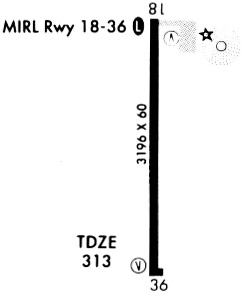
| Runways: | 18/36 |
| Longest Runway: | 18/36 is 3196 ft (974 m) long |
| Runways with an Instrument Approach: |
KCHQ Airport Runway Details
| Runway 18/36 | 3196 ft x 60 ft (974 m x 18 m) | |
| Surface: | Asphalt - Good condition - Aggregate friction seal coat | |
| Runway Edge Lights: | Medium Intensity | |
Runway Weight Bearing Capacity (in thousands of pounds) |
||
| Single Wheel Landing Gear: | 12.5 | |
Runway 18 |
Runway 36 |
|
Elevation: |
313.0 | 313.0 |
Latitude: |
36-50-47.5350N | 36-50-15.9350N |
Longitude: |
089-21-34.6830W | 089-21-34.7930W |
|
Runway True Alignment: |
180 | 360 |
Glide Path Angle: |
3.0 degrees | 3.0 degrees |
Traffic Pattern: |
Left | Left |
Runway Markings Type: |
Nonprecision Instrument | Nonprecision Instrument |
Runway Markings Condition: |
Poor | Poor |
Visual Glide Slope Indicators: |
2-Light PAPI On Left Side Of Runway | 2-Light PAPI On Left Side Of Runway |
REIL: |
Yes | Yes |
Threshold Crossing Height: |
40 | 40 |
Services
Airframe Repair: |
Major |
Powerplant Repair: |
Minor |
Fuel Available: |
100LL, Jet A |
Landing Fees: |
No |
Parking: |
Tiedowns available |
Maps & Diagrams
KCHQ Sectional
Flight Planning
at skyvector.com
at skyvector.com