Location
Latitude: |
36-17-51.0950N (36.297526) |
Longitude: |
077-10-15.0700W (-77.170853) |
Elevation: |
66.6 feet MSL (20 m MSL) |
Magnetic Variation: |
10.3 W (as of April 2024 from WMM2020 model) |
Time Zone: |
UTC -5.0 (Standard Time) UTC -4.0 (Daylight Savings Time) |
From City: |
09 N.M. W of Ahoskie, North Carolina |
Found On: |
Washington Chart |
FAA Region: |
ASO |
Contacts
Manager: |
Publicly owned: |
| HENRY JOYNER 140 TRI-COUNTY AIRPORT RD AULANDER, NC 27805 252-345-0111 |
TRI-COUNTY AIRPORT AUTH. 140 TRI-COUNTY AIRPORT RD AULANDER, NC 27805 252-345-9962 |
Operations
Airport Status: |
Operational |
Facility Use: |
Public |
Type: |
Airport |
Control tower: |
No |
Attendance (Months/Days/Hours): |
Months/Days/Hours ALL/MON-SAT/0900-DUSK |
Boundary ARTCC: |
ZDC (Washington) |
Responsible ARTCC: |
ZDC (Washington) |
Lighting Schedule: |
SEE RMK |
Segmented Circle Indicator: |
Yes |
Traffic Pattern Altitude (MSL): |
1067 feet (325 m) |
NOTAMs Facility: |
ASJ |
NOTAM-D Service: |
Yes |
International Airport of Entry: |
No |
Customs Landing Rights: |
No |
Military Landing Rights: |
Yes |
Civil/Military Joint Use: |
No |
Based Aircraft
| Single Engine: | 10 |
Annual Operations (as of 05/30/2021)
| Total Operations: | 13100 | |
| Air Taxi: | 200 | 1.5% |
| GA Local: | 6000 | 45.8% |
| GA Itinerant: | 6800 | 51.9% |
| Military Aircraft: | 100 | 0.8% |
Communications
| CTAF: | 122.800 |
| Unicom: | 122.800 |
| AWOS-3: | 119.075 (252-345-2967) |
- APCH/DEP SVC PRVDD BY WASHINGTON ARTCC (ZDC) ON 123.85/279.65 (NEW BERN RCAG).
Fixed Based Operators (FBOs) & Fuel
(Click on a business for detail)
Please help us keep this information up to date. This is a FREE SERVICE just like everything else on Airport Guide! If you see that a business needs to be added, modified, or deleted please fill out our Update Form.
To add, modify, or delete a business click here.
Please help us keep this information up to date. This is a FREE SERVICE just like everything else on Airport Guide! If you see that a business needs to be added, modified, or deleted please fill out our Update Form.
Area Code: 252 |
| Business Name | Frequency | Phone | Fuel Grade |
|---|---|---|---|
| Tri Air
Update FBO info |
345-0111 | 100LL, Jet A |
Flight Service Stations
| Primary | Alternate | |
| FSS on Field: | N | |
| FSS Name (ID): | Raleigh(RDU) | |
| Frequency: | ||
| Toll Free Phone: | 1-800-WX-BRIEF |
Instrument Procedures / Charts
FAA Terminal Procedures valid from 0901Z 03/21/24 to 0901Z 04/18/24.
There are various types of charts available for an airport. They are listed in the Page Type column. Here is a legend for those types:
APD - Airport Diagram
DP - Departure Procedure Charts
HOT - Hot Spots
IAP - Instrument Approach Procedure Charts
MIN - Minimums
STAR - Standard Terminal Arrival Charts
| Page Type | Page Name | Volume | Action Since Last Cycle |
|---|---|---|---|
| IAP | RNAV (GPS) RWY 01 | SE-2 | |
| IAP | RNAV (GPS) RWY 19 | SE-2 | |
| MIN | ALTERNATE MINIMUMS | SE-2 | |
| MIN | TAKEOFF MINIMUMS | SE-2 |
Terminal Procedures are only available for airports in several countries with more being added all the time. If you are looking for a specific country's charts, please send an email to support(at)airportguide.com stating the country name. This will be used to prioritize the implementation.
Navigation Aids (Navaids) near KASJ
| Dist (NM) | ID | Morse Code | Name | Type | Freq | True Hdg | Mag Hdg |
|---|---|---|---|---|---|---|---|
| 15.2 | CVI | _ . _ . . . . _ . . | Cofield | VORTAC | 114.60 | 72 | 82 |
| 22.8 | ELQ | . . _ . . _ _ . _ | Emporia | NDB | 261 | 327 | 337 |
| 26.1 | FKN | . . _ . _ . _ _ . | Franklin | VORTAC | 110.60 | 16 | 26 |
| 26.3 | MCZ | _ _ _ . _ . _ _ . . | Williamston | NDB | 336 | 180 | 190 |
| 27.4 | RZZ | . _ . _ _ . . _ _ . . | Rapids | NDB | 407 | 288 | 298 |
| 28.3 | ETC | . _ _ . _ . | Tarboro | NDB | 257 | 220 | 230 |
| 31.0 | RK | . _ . _ . _ | Waley | NDB | 249 | 54 | 64 |
| 32.2 | TYI | _ _ . _ _ . . | Tar River | VORTAC | 117.80 | 233 | 243 |
| 33.5 | EDE | . _ . . . | Edenton | NDB | 265 | 118 | 128 |
| 36.8 | AQE | . _ _ _ . _ . | Alwood | NDB | 230 | 195 | 205 |
| 40.8 | PGV | . _ _ . _ _ . . . . _ | Belvoir | FAN MARKER | 194 | 204 | |
| 41.9 | AKQ | . _ _ . _ _ _ . _ | Wakefield | NDB | 274 | 11 | 21 |
| 42.2 | EY | . _ . _ _ | Chesi | NDB | 233 | 64 | 75 |
| 42.3 | LLW | . _ . . . _ . . . _ _ | Woodville | NDB | 254 | 92 | 103 |
| 46.6 | AEA | . _ . . _ | Jones | NDB | 373 | 294 | 304 |
| 47.1 | LVL | . _ . . . . . _ . _ . . | Lawrenceville | VORTAC | 112.90 | 311 | 321 |
| 47.4 | RNW | . _ . _ . . _ _ | Chocowinity | NDB | 388 | 176 | 186 |
| 48.2 | ECG | . _ . _ . _ _ . | Elizabeth City | VOR-DME | 112.50 | 92 | 103 |
| 48.8 | MBV | _ _ _ . . . . . . _ | Mecklenburg/Dcmsnd | NDB | 356 | 299 | 309 |
| 55.0 | OR | _ _ _ . _ . | Ingle | NDB | 329 | 53 | 64 |
Nearby Airports with Fuel
Notices to Airmen (NOTAMS)
Remarks
| A110-3 | RWY 01/19 -4 FT DITCH 120 FT L & R OF CNTRLN. |
| A110-4 | FOR CD CTC WASHINGTON ARTCC AT 703-771-3587. |
| A16 | FOR ARPT AMGR AFTER HOURS CALL 252-395-0822. |
| A58-19 | DUE TO 16 FT TREES 0-200 FT FM THLD OFFSET 168 FT L OF CNTRLN AND 10 FT TREES 0-200 FT FM THLD OFFSET 113 FT R OF CNTRLN. |
| A70-FUEL-10 | 0LL JET A - 24 HR SELF SERVICE AVBL WITH CREDIT CARD. |
| A81-APT | ACTVT REIL RWY 01 & 19; MIRL RWY 01/19 - CTAF. PAPI RWY 01 & 19 OPER CONSLY. |
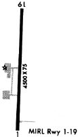
Runways
Runway Summary
| Runways: | 01/19 |
| Longest Runway: | 01/19 is 4501 ft (1372 m) long |
| Runways with an Instrument Approach: |
KASJ Airport Runway Details
| Runway 01/19 | 4501 ft x 75 ft (1372 m x 23 m) | |
| Runway Length Source: | 3RD PARTY SURVEY as of 11/03/2022 | |
| Surface: | Asphalt - Good condition - No special surface treatment | |
| Runway Edge Lights: | Medium Intensity | |
Runway Weight Bearing Capacity (in thousands of pounds) |
||
| Single Wheel Landing Gear: | 35.0 | |
| Dual Wheel Landing Gear: | 45.0 | |
Runway 01 |
Runway 19 |
|
Elevation: |
66.5 | 66.3 |
Latitude: |
36-17-28.8473N | 36-18-13.3430N |
Longitude: |
077-10-14.3256W | 077-10-15.8152W |
|
Runway True Alignment: |
358 | 178 |
Glide Path Angle: |
3.2 degrees | 3.0 degrees |
Traffic Pattern: |
Left | Left |
Runway Markings Type: |
Nonprecision Instrument | Nonprecision Instrument |
Runway Markings Condition: |
Good | Good |
Object at End: |
ROAD | TREES |
Object Height: |
15 | 22 |
Distance from End: |
437 | 383 |
Object Centerline Offset: |
0 ft. left and right of centerline | 236 ft. right of centerline |
Visual Glide Slope Indicators: |
2-Light PAPI On Left Side Of Runway | 2-Light PAPI On Left Side Of Runway |
REIL: |
Yes | Yes |
Threshold Crossing Height: |
44 | 40 |
Services
Airframe Repair: |
Minor |
Powerplant Repair: |
Minor |
Bottled Oxygen: |
None |
Bulk Oxygen: |
None |
Fuel Available: |
100LL |
Landing Fees: |
No |
Parking: |
Hangars and tiedowns available |
Other Services: |
Tailwheel instruction |
Maps & Diagrams
KASJ Sectional
Flight Planning
at skyvector.com
at skyvector.com