Location
Latitude: |
43-14-10.5000N (43.23625) |
Longitude: |
120-39-52.9000W (-120.664694) |
Elevation: |
4320.1 feet MSL (1317 m MSL) |
Magnetic Variation: |
13.9 E (as of April 2024 from WMM2020 model) |
Time Zone: |
UTC -8.0 (Standard Time) UTC -7.0 (Daylight Savings Time) |
From City: |
01 N.M. SE of Christmas Valley, Oregon |
Found On: |
Klamath Falls Chart |
FAA Region: |
ANM |
Contacts
Manager: |
Publicly owned: |
| GLENNA WADE PO BOX 181 CHRISTMAS VALLEY, OR 97638 541-576-2216 |
CHRISTMAS VALLEY PARKS PO BOX 181 CHRISTMAS VALLEY, OR 97638 541-576-2216 |
Operations
Airport Status: |
Operational |
Facility Use: |
Public |
Type: |
Airport |
Activation Date: |
10/1964 |
Control tower: |
No |
Attendance (Months/Days/Hours): |
Months/Days/Hours Unattended |
Boundary ARTCC: |
ZSE (Seattle) |
Responsible ARTCC: |
ZSE (Seattle) |
Lighting Schedule: |
SEE RMK |
Segmented Circle Indicator: |
Yes |
Traffic Pattern Altitude (MSL): |
5320 feet (1622 m) |
NOTAMs Facility: |
MMV |
NOTAM-D Service: |
Yes |
International Airport of Entry: |
No |
Customs Landing Rights: |
No |
Based Aircraft
Annual Operations (as of 06/09/2019)
| Total Operations: | 3600 | |
| Air Taxi: | 100 | 2.8% |
| GA Local: | 1000 | 27.8% |
| GA Itinerant: | 2500 | 69.4% |
Communications
| CTAF: | 122.800 |
| Unicom: | 122.800 |
- APCH/DEP CTL SVC PRVDD BY SEATTLE ARTCC (ZSE) ON 127.6/346.35 (LAKEVIEW RCAG).
Fixed Based Operators (FBOs) & Fuel
(Click on a business for detail)
Please help us keep this information up to date. This is a FREE SERVICE just like everything else on Airport Guide! If you see that a business needs to be added, modified, or deleted please fill out our Update Form.
To add, modify, or delete a business click here.
Please help us keep this information up to date. This is a FREE SERVICE just like everything else on Airport Guide! If you see that a business needs to be added, modified, or deleted please fill out our Update Form.
Area Code: 541 |
| Business Name | Frequency | Phone | Fuel Grade |
|---|
Flight Service Stations
| Primary | Alternate | |
| FSS on Field: | N | |
| FSS Name (ID): | Mc Minnville(MMV) | |
| Frequency: | ||
| Toll Free Phone: | 1-800-WX-BRIEF |
Instrument Procedures / Charts
FAA Terminal Procedures valid from 0901Z 03/21/24 to 0901Z 04/18/24.
There are various types of charts available for an airport. They are listed in the Page Type column. Here is a legend for those types:
APD - Airport Diagram
DP - Departure Procedure Charts
HOT - Hot Spots
IAP - Instrument Approach Procedure Charts
MIN - Minimums
STAR - Standard Terminal Arrival Charts
| Page Type | Page Name | Volume | Action Since Last Cycle |
|---|---|---|---|
| IAP | RNAV (GPS)-A | NW-1 | Changed |
| MIN | TAKEOFF MINIMUMS | NW-1 |
Terminal Procedures are only available for airports in several countries with more being added all the time. If you are looking for a specific country's charts, please send an email to support(at)airportguide.com stating the country name. This will be used to prioritize the implementation.
Navigation Aids (Navaids) near 62S
| Dist (NM) | ID | Morse Code | Name | Type | Freq | True Hdg | Mag Hdg |
|---|---|---|---|---|---|---|---|
| 45.1 | LKV | . _ . . _ . _ . . . _ | Lakeview | VORTAC | 112.00 | 171 | 157 |
| 66.1 | RD | . _ . _ . . | Bodey | NDB | 411 | 346 | 332 |
| 67.0 | DSD | _ . . . . . _ . . | Deschutes | VORTAC | 117.60 | 335 | 321 |
| 77.5 | ILR | . . . _ . . . _ . | Wildhorse | VOR-DME | 114.55 | 73 | 59 |
| 80.1 | LMT | . _ . . _ _ _ | Klamath Falls | VORTAC | 115.90 | 216 | 202 |
| 94.2 | IMB | . . _ _ _ . . . | Kimberly | VOR-DME | 115.60 | 25 | 11 |
Nearby Airports with Fuel
| Dist (NM) | Name (Airport IDs) | True Hdg | Mag Hdg | Fuel Grade |
|---|---|---|---|---|
| 51.5 | Sunriver Airport (SUO S21) |
318 | 304 | 100LL, Jet A, Jet A+ |
| 56.5 | Bend Municipal Airport (KBDN BDN) |
335 | 321 | 100LL, Jet A |
| 64.0 | Prineville Airport (PRZ S39) |
350 | 336 | 100LL, Jet A |
| 64.6 | Roberts Field Airport (RDM KRDM RDM) |
341 | 327 | 100LL, Jet A |
| 65.6 | Lake County Airport (LKV KLKV LKV) |
169 | 155 | 100LL, Jet A |
| 77.5 | Burns Municipal Airport (BNO KBNO BNO) |
73 | 59 | 100LL, Jet A |
| 80.1 | Crater Lake/Klamath Regional Airport (LMT KLMT LMT) |
216 | 202 | 100LL, Jet A |
| 86.4 | Tulelake Municipal Airport (O81) |
201 | 187 | 100LL |
| 88.6 | Madras Municipal Airport (MDJ S33) |
346 | 332 | 100LL, Jet A |
Notices to Airmen (NOTAMS)
Remarks
| A11 | CHRISTMAS VALLEY PARK & RECREATION DISTRICT. |
| A110-1 | FOR CD CTC SEATTLE ARTCC AT 253-351-3694. |
| A110-2 | REMOTE CTLD ACFT IN VCNTY. |
| A81-APT | ACTVT MIRL RY 07/25 & PAPI RY 25 - CTAF. |
| A82 | UNICOM MONITORED IRREGULARLY. |
Runways
Runway Summary
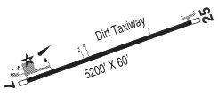
| Runways: | 07/25 |
| Longest Runway: | 07/25 is 5200 ft (1585 m) long |
| Runways with an Instrument Approach: |
62S Airport Runway Details
| Runway 07/25 | 5200 ft x 60 ft (1585 m x 18 m) | |
| Runway Length Source: | 3RD PARTY SURVEY as of 05/24/2015 | |
| Surface: | Asphalt - Good condition - No special surface treatment | |
| Runway Edge Lights: | Medium Intensity | |
Runway Weight Bearing Capacity (in thousands of pounds) |
||
| Single Wheel Landing Gear: | 12.0 | |
Runway 07 |
Runway 25 |
|
Elevation: |
4319.5 | 4320.0 |
Latitude: |
43-14-10.6386N | 43-14-10.3811N |
Longitude: |
120-40-27.9976W | 120-39-17.7703W |
|
Runway True Alignment: |
090 | 270 |
Glide Path Angle: |
0.0 degrees | 3.0 degrees |
Traffic Pattern: |
Left | Left |
Runway Markings Type: |
Basic | Basic |
Runway Markings Condition: |
Good | Good |
Visual Glide Slope Indicators: |
2-Light PAPI On Left Side Of Runway | |
Threshold Crossing Height: |
39 |
Services
Airframe Repair: |
Major |
Powerplant Repair: |
Major |
Bottled Oxygen: |
High Pressure / Low Pressure |
Bulk Oxygen: |
None |
Fuel Available: |
100LL, Jet A |
Landing Fees: |
No |
Parking: |
Hangars and tiedowns available |
Maps & Diagrams
62S Sectional
Flight Planning
at skyvector.com
at skyvector.com