Location
Latitude: |
42-41-29.9000N (42.691639) |
Longitude: |
073-34-47.9000W (-73.579972) |
Elevation: |
440.0 feet MSL (134 m MSL) |
Magnetic Variation: |
13.2 W (as of April 2024 from WMM2020 model) |
Time Zone: |
UTC -5.0 (Standard Time) UTC -4.0 (Daylight Savings Time) |
From City: |
06 N.M. SE of Troy, New York |
Found On: |
New York Chart |
FAA Region: |
AEA |
Contacts
Manager: |
Privately owned: |
| GEORGE DUJACK, JR. P.O. 304 POSTENKILL, NY 12140 (518) 596-5947 |
DU THIS DU THAT INC PO BOX 304 POSTENKILL, NY 12140 (518) 596-5947 |
Operations
Airport Status: |
Operational |
Facility Use: |
Public |
Type: |
Airport |
Activation Date: |
06/1969 |
Control tower: |
No |
Attendance (Months/Days/Hours): |
Months/Days/Hours Unattended |
Boundary ARTCC: |
ZBW (Boston) |
Responsible ARTCC: |
ZBW (Boston) |
Segmented Circle Indicator: |
No |
Traffic Pattern Altitude (MSL): |
1440 feet (439 m) |
NOTAMs Facility: |
BTV |
NOTAM-D Service: |
Yes |
International Airport of Entry: |
No |
Customs Landing Rights: |
No |
Civil/Military Joint Use: |
No |
Based Aircraft
Annual Operations (as of 04/25/2019)
| Total Operations: | 800 | |
| GA Local: | 750 | 93.8% |
| GA Itinerant: | 50 | 6.2% |
Communications
| CTAF: | 122.700 |
| Unicom: | 122.700 |
Fixed Based Operators (FBOs) & Fuel
(Click on a business for detail)
Please help us keep this information up to date. This is a FREE SERVICE just like everything else on Airport Guide! If you see that a business needs to be added, modified, or deleted please fill out our Update Form.
To add, modify, or delete a business click here.
Please help us keep this information up to date. This is a FREE SERVICE just like everything else on Airport Guide! If you see that a business needs to be added, modified, or deleted please fill out our Update Form.
Area Code: 518 |
| Business Name | Frequency | Phone | Fuel Grade |
|---|
Flight Service Stations
| Primary | Alternate | |
| FSS on Field: | N | |
| FSS Name (ID): | Burlington(BTV) | |
| Frequency: | ||
| Toll Free Phone: | 1-800-WX-BRIEF |
Instrument Procedures / Charts
Terminal Procedures are only available for airports in several countries with more being added all the time. If you are looking for a specific country's charts, please send an email to support(at)airportguide.com stating the country name. This will be used to prioritize the implementation.
Navigation Aids (Navaids) near 5B7
| Dist (NM) | ID | Morse Code | Name | Type | Freq | True Hdg | Mag Hdg |
|---|---|---|---|---|---|---|---|
| 10.4 | ALB | . _ . _ . . _ . . . | Albany | VORTAC | 115.30 | 288 | 301 |
| 11.1 | ALB | . _ . _ . . _ . . . | Albany | VOT | 108.20 | 285 | 298 |
| 18.4 | HEU | . . . . . . . _ | Hunter | NDB | 356 | 302 | 315 |
| 20.9 | CAM | _ . _ . . _ _ _ | Cambridge | VOR-DME | 115.00 | 29 | 42 |
| 27.1 | PFH | . _ _ . . . _ . . . . . | Philmont | NDB | 272 | 193 | 206 |
| 31.5 | GBR | _ _ . _ . . . . _ . | Great Barrington | NDB | 395 | 165 | 178 |
| 33.8 | GF | _ _ . . . _ . | Ganse | NDB | 209 | 358 | 371 |
| 34.5 | VWD | . . . _ . _ _ _ . . | Mount Snow | NDB | 224 | 65 | 78 |
| 36.8 | CTR | _ . _ . _ . _ . | Chester | VOR-DME | 115.10 | 130 | 143 |
| 37.9 | JJH | . _ _ _ . _ _ _ . . . . | Johnstown | NDB | 523 | 299 | 312 |
| 39.0 | GFL | _ _ . . . _ . . _ . . | Glens Falls | VORTAC | 110.20 | 357 | 370 |
| 49.7 | BAF | _ . . . . _ . . _ . | Barnes | VORTAC | 113.00 | 129 | 142 |
| 55.3 | CEF | _ . _ . . . . _ . | Westover | TACAN | 114.00 | 122 | 135 |
| 55.3 | PWL | . _ _ . . _ _ . _ . . | Pawling | VOR-DME | 114.30 | 180 | 193 |
| 55.7 | SXD | . . . _ . . _ _ . . | Springfield | NDB | 265 | 51 | 64 |
| 57.1 | EEN | . . _ . | Keene | DME | 109.4 | 83 | 96 |
| 57.2 | RUT | . _ . . . _ _ | Rutland | DME | 111 | 28 | 41 |
| 57.6 | ORE | _ _ _ . _ . . | Orange | NDB | 205 | 96 | 109 |
| 59.9 | BDL | _ . . . _ . . . _ . . | Bradley | VORTAC | 109.00 | 138 | 151 |
| 60.4 | BDL | _ . . . _ . . . _ . . | Bradley | VOT | 111.40 | 138 | 151 |
Nearby Airports with Fuel
Notices to Airmen (NOTAMS)
Remarks
| A110-2 | DEER & BIRDS ON & INVOF ARPT. |
| A110-3 | SRNDG TRRN SLOPES DOWN TO RWY; DUE TO HIGHER SRNDG TRRN RCMD USE OF THE FLWG PROCS: DEP RWY 36 - USE BEST ANGLE OF CLIMB SPEED UNTIL WELL CLEAR OF RESIDENTIAL AREA N OF RWY 36; |
| A110-4 | ARRS RWY 18 - MNTN SUF ALT ON FINAL SO AS TO AVOID LOW ALT AND/OR HIGH POWER OVER RESIDENTIAL AREA WHICH UNDERLIES FINAL APCH TO RWY 18. DEPS RWY 18 & ARRS RWY 36 - USE NORMAL PROCS. |
| A110-5 | TSNT ACFT CALL (518) 596-5947 FOR FIELD CONDS PRIOR TO ARR. |
| A110-6 | FOR CD CTC ALBANY APCH AT 518-862-2299. |
| A31-18/36 | RWY 18 FIRST 40 FT OVERGROWN WITH GRASS. |
| A33-18/36 | WIDESPREAD SVR CRACKING AND DISTORTION. SVR SPALLING AND FAULTING. WIDESPREAD VEGETATION. |
| A42-18 | RWY 18 MARKINGS NOT VSB. |
| A42-36 | MARKING NRS FADED. |
| A58-18 | TREE 115 FT RIGHT AT THLD. |
| A58-36 | VEGETATION CVRD HILL 66 FT RIGHT. |
| E111 | VFR ONLY |
Runways
Runway Summary
| Runways: | 18/36 |
| Longest Runway: | 18/36 is 2670 ft (814 m) long |
| Runways with an Instrument Approach: |
5B7 Airport Runway Details
| Runway 18/36 | 2670 ft x 50 ft (814 m x 15 m) | |
| Surface: | Asphalt - Failed condition - No special surface treatment | |
Runway Weight Bearing Capacity (in thousands of pounds) |
||
| Single Wheel Landing Gear: | 8.0 | |
Runway 18 |
Runway 36 |
|
Elevation: |
436.0 | 438.0 |
Latitude: |
42-41-42.3800N | 42-41-17.4253N |
Longitude: |
073-34-53.7319W | 073-34-42.1357W |
|
Runway True Alignment: |
161 | 341 |
Glide Path Angle: |
0.0 degrees | 0.0 degrees |
Traffic Pattern: |
Left | Left |
Runway Markings Type: |
None | Basic |
Runway Markings Condition: |
Poor | |
Object at End: |
TREES | TREES |
Object Height: |
44 | 100 |
Distance from End: |
343 | 263 |
Object Centerline Offset: |
102 ft. left of centerline | 110 ft. left and right of centerline |
Services
Airframe Repair: |
Major |
Powerplant Repair: |
Major |
Bottled Oxygen: |
None |
Bulk Oxygen: |
None |
Fuel Available: |
100LL, Jet A |
Landing Fees: |
Yes |
Parking: |
Hangars and tiedowns available |
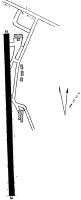
Maps & Diagrams
5B7 Sectional
Flight Planning
at skyvector.com
at skyvector.com