Location
Latitude: |
45-08-08.5469N (45.135707) |
Longitude: |
087-11-17.2611W (-87.188128) |
Elevation: |
763.2 feet MSL (233 m MSL) |
Magnetic Variation: |
4.9 W (as of April 2024 from WMM2020 model) |
Time Zone: |
UTC -6.0 (Standard Time) UTC -5.0 (Daylight Savings Time) |
From City: |
01 N.M. SW of Ephraim, Wisconsin |
Found On: |
Green Bay Chart |
FAA Region: |
AGL |
Contacts
Manager: |
Publicly owned: |
| TRAVIS THYSSEN P O BOX 850 FISH CREEK, WI 54212 920-868-1714 |
VILLAGE OF EPHRAIM PO BOX 850 FISH CREEK, WI 54212 920-868-1714 |
Operations
Airport Status: |
Operational |
Facility Use: |
Public |
Type: |
Airport |
Activation Date: |
10/1947 |
Control tower: |
No |
Attendance (Months/Days/Hours): |
Months/Days/Hours JUN-OCT/FRI/1500-1800 |
Boundary ARTCC: |
ZMP (Minneapolis) |
Responsible ARTCC: |
ZMP (Minneapolis) |
Lighting Schedule: |
SEE RMK |
Segmented Circle Indicator: |
Yes |
Traffic Pattern Altitude (MSL): |
1763 feet (537 m) |
NOTAMs Facility: |
GRB |
NOTAM-D Service: |
Yes |
International Airport of Entry: |
No |
Customs Landing Rights: |
No |
Military Landing Rights: |
Yes |
Civil/Military Joint Use: |
No |
Based Aircraft
| Single Engine: | 18 |
| Multi Engine: | 2 |
| GA Helicopters: | 2 |
Annual Operations (as of 08/16/2023)
| Total Operations: | 9300 | |
| Air Taxi: | 300 | 3.2% |
| GA Local: | 3500 | 37.6% |
| GA Itinerant: | 5500 | 59.1% |
Communications
| CTAF: | 123.000 |
| Unicom: | 123.000 |
| Approach: | GREEN BAY 120.3 120.3 MINNEAPOLIS ARTCC |
| Departure: | GREEN BAY 120.3 120.3 MINNEAPOLIS ARTCC |
| AWOS-3PT: | 124.175 (920-854-5559) |
- APCH/DEP SVC PRVDD BY MINNEAPOLIS ARTCC ON FREQ 127.65 (ESCANABA RCAG) WHEN GREEN BAY APCH CTL CLSD.
Fixed Based Operators (FBOs) & Fuel
(Click on a business for detail)
Please help us keep this information up to date. This is a FREE SERVICE just like everything else on Airport Guide! If you see that a business needs to be added, modified, or deleted please fill out our Update Form.
To add, modify, or delete a business click here.
Please help us keep this information up to date. This is a FREE SERVICE just like everything else on Airport Guide! If you see that a business needs to be added, modified, or deleted please fill out our Update Form.
Area Code: 920 |
| Business Name | Frequency | Phone | Fuel Grade |
|---|---|---|---|
| Eagle Harbor Air Service, Inc.
Update FBO info |
Unicom 123.0 | 854-9711 | 100LL |
Flight Service Stations
| Primary | Alternate | |
| FSS on Field: | N | |
| FSS Name (ID): | Green Bay(GRB) | |
| Frequency: | ||
| Toll Free Phone: | 1-800-WX-BRIEF |
Instrument Procedures / Charts
FAA Terminal Procedures valid from 0901Z 03/21/24 to 0901Z 04/18/24.
There are various types of charts available for an airport. They are listed in the Page Type column. Here is a legend for those types:
APD - Airport Diagram
DP - Departure Procedure Charts
HOT - Hot Spots
IAP - Instrument Approach Procedure Charts
MIN - Minimums
STAR - Standard Terminal Arrival Charts
| Page Type | Page Name | Volume | Action Since Last Cycle |
|---|---|---|---|
| IAP | RNAV (GPS) RWY 14 | EC-3 | |
| IAP | RNAV (GPS) RWY 32 | EC-3 | |
| MIN | ALTERNATE MINIMUMS | EC-3 | |
| MIN | TAKEOFF MINIMUMS | EC-3 |
Terminal Procedures are only available for airports in several countries with more being added all the time. If you are looking for a specific country's charts, please send an email to support(at)airportguide.com stating the country name. This will be used to prioritize the implementation.
Navigation Aids (Navaids) near 3D2
| Dist (NM) | ID | Morse Code | Name | Type | Freq | True Hdg | Mag Hdg |
|---|---|---|---|---|---|---|---|
| 19.6 | MNM | _ _ _ . _ _ | Menominee | DME | 109.6 | 277 | 282 |
| 20.5 | SUE | . . . . . _ . | Sturgeon Bay | NDB | 414 | 209 | 214 |
| 22.0 | TN | _ _ . | Tribe | NDB | 239 | 258 | 263 |
| 34.5 | OCQ | _ _ _ _ . _ . _ _ . _ | Oconto | NDB | 388 | 243 | 248 |
| 35.3 | ES | . . . . | Pikle | NDB | 344 | 357 | 362 |
| 35.5 | ESC | . . . . _ . _ . | Escanaba | VOR-DME | 110.80 | 6 | 11 |
| 55.2 | GRB | _ _ . . _ . _ . . . | Green Bay | VORTAC | 115.50 | 231 | 236 |
| 56.4 | IMT | . . _ _ _ | Iron Mountain | VOR-DME | 111.20 | 316 | 321 |
| 59.8 | SG | . . . _ _ . | Depre | NDB | 332 | 222 | 227 |
| 60.3 | MT | _ _ _ | Mawoc | NDB | 362 | 201 | 206 |
| 61.2 | GR | _ _ . . _ . | Famis | NDB | 356 | 227 | 231 |
| 64.0 | MTW | _ _ _ . _ _ | Manitowoc | DME | 111 | 199 | 204 |
| 65.4 | MBL | _ _ _ . . . . _ . . | Manistee | DME | 111.4 | 142 | 147 |
| 66.0 | ISQ | . . . . . _ _ . _ | Schoolcraft County | DME | 114.85 | 39 | 44 |
| 68.4 | MB | _ _ _ . . . | Jepot | NDB | 254 | 138 | 143 |
| 72.6 | CLI | _ . _ . . _ . . . . | Clintonville | NDB | 209 | 245 | 249 |
| 73.9 | SAW | . . . . _ . _ _ | Sawyer | VOR-DME | 117.10 | 353 | 358 |
| 75.1 | TVC | _ . . . _ _ . _ . | Traverse City | VOR-DME | 114.60 | 111 | 117 |
| 75.6 | AQ | . _ _ _ . _ | Kooky | NDB | 407 | 223 | 227 |
| 76.3 | SJX | . . . . _ _ _ _ . . _ | St James | NDB | 382 | 63 | 69 |
Nearby Airports with Fuel
Notices to Airmen (NOTAMS)
Remarks
| A11 | & TOWN OF GIBRALTAR. |
| A110-1 | DEER NR MOVEMENT AREAS. |
| A110-2 | FOR CD CTC GREEN BAY APCH AT 920-431-5741, WHEN GREEN BAY APCH CLSD, FOR CD CTC MINNEAPOLIS ARTCC AT 651-463-5588. |
| A16 | ARPT OFC PHONE NR 920-854-3312, AVBL JUN-OCT, FRI-SUN. |
| A33-01/19 | SLOPES MDTELY DOWN TO SOUTH--CANNOT SEE ONE END FM THE OTHER. |
| A42-01 | MKD WITH YELLOW CONES. |
| A42-19 | MKD WITH YELLOW CONES. |
| A70-FUEL-10 | 0LL 24 HR SELF SVC FUEL AVBL WITH CREDIT CARD. |
| A81-APT | MIRL RWY 14/32 PRESET LOW SS-SR; INCR INTST AND ACTVT PAPI RWY 14 & 32 - CTAF. |
Runways
Runway Summary
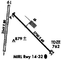
| Runways: | 01/19 14/32 |
| Longest Runway: | 14/32 is 2697 ft (822 m) long |
| Runways with an Instrument Approach: |
3D2 Airport Runway Details
| Runway 01/19 | 2324 ft x 100 ft (708 m x 30 m) | |
| Runway Length Source: | FAA OE/AAA as of 06/05/2014 | |
| Surface: | Turf - Fair condition - No special surface treatment | |
Runway 01 |
Runway 19 |
|
Elevation: |
754.9 | 762.9 |
Latitude: |
45-07-58.6500N | 45-08-21.3700N |
Longitude: |
087-11-28.9700W | 087-11-24.4800W |
|
Runway True Alignment: |
008 | 188 |
Glide Path Angle: |
0.0 degrees | 0.0 degrees |
Traffic Pattern: |
Left | Left |
Runway Markings Type: |
None | None |
| Runway 14/32 | 2697 ft x 60 ft (822 m x 18 m) | |
| Runway Length Source: | 3RD PARTY SURVEY as of 10/20/2010 | |
| Surface: | Turf - Fair condition - No special surface treatment | |
| Runway Edge Lights: | Medium Intensity | |
Runway Weight Bearing Capacity (in thousands of pounds) |
||
| Single Wheel Landing Gear: | 12.5 | |
Runway 14 |
Runway 32 |
|
Elevation: |
763.2 | 750.9 |
Latitude: |
45-08-16.9152N | 45-07-57.6788N |
Longitude: |
087-11-22.1401W | 087-10-56.1199W |
|
Runway True Alignment: |
136 | 316 |
Glide Path Angle: |
3.5 degrees | 3.0 degrees |
Traffic Pattern: |
Left | Left |
Runway Markings Type: |
Nonprecision Instrument | Nonprecision Instrument |
Runway Markings Condition: |
Fair | Fair |
Visual Glide Slope Indicators: |
2-Light PAPI On Left Side Of Runway | 2-Light PAPI On Left Side Of Runway |
REIL: |
No | No |
Touchdown Lights: |
No | No |
Centerline Lights: |
No | No |
Threshold Crossing Height: |
24 | 25 |
Services
Fuel Available: |
100LL, Jet A+ |
Landing Fees: |
Yes |
Parking: |
Hangars and tiedowns available |
Maps & Diagrams
3D2 Sectional
Flight Planning
at skyvector.com
at skyvector.com