Location
Latitude: |
40-20-00.2490N (40.333403) |
Longitude: |
079-46-45.1640W (-79.779212) |
Elevation: |
1250.0 feet MSL (381 m MSL) |
Magnetic Variation: |
9.4 W (as of April 2024 from WMM2020 model) |
Time Zone: |
UTC -5.0 (Standard Time) UTC -4.0 (Daylight Savings Time) |
From City: |
04 N.M. W of Irwin, Pennsylvania |
Found On: |
Detroit Chart |
FAA Region: |
AEA |
Contacts
Manager: |
Privately owned: |
| PAMELA EYLER 1381 COLONIAL MANOR RD MC KEESPORT, PA 15131 412-751-9009 |
EYLERAIRE 1381 COLONIAL MANOR RD MC KEESPORT, PA 15131-4305 412-751-9009 |
Operations
Airport Status: |
Operational |
Facility Use: |
Public |
Type: |
Airport |
Activation Date: |
11/1948 |
Control tower: |
No |
Attendance (Months/Days/Hours): |
Months/Days/Hours IREG |
Boundary ARTCC: |
ZOB (Cleveland) |
Responsible ARTCC: |
ZOB (Cleveland) |
Segmented Circle Indicator: |
No |
Traffic Pattern Altitude (MSL): |
2250 feet (686 m) |
NOTAMs Facility: |
AOO |
NOTAM-D Service: |
Yes |
International Airport of Entry: |
No |
Customs Landing Rights: |
No |
Based Aircraft
| Single Engine: | 3 |
Annual Operations (as of 08/04/2021)
| Total Operations: | 78 | |
| GA Local: | 60 | 76.9% |
| GA Itinerant: | 16 | 20.5% |
| Military Aircraft: | 2 | 2.6% |
Communications
| CTAF: | 122.900 |
Fixed Based Operators (FBOs) & Fuel
(Click on a business for detail)
Please help us keep this information up to date. This is a FREE SERVICE just like everything else on Airport Guide! If you see that a business needs to be added, modified, or deleted please fill out our Update Form.
To add, modify, or delete a business click here.
Please help us keep this information up to date. This is a FREE SERVICE just like everything else on Airport Guide! If you see that a business needs to be added, modified, or deleted please fill out our Update Form.
Area Code: 412 |
| Business Name | Frequency | Phone | Fuel Grade |
|---|---|---|---|
| Eyler Aire
Update FBO info |
Unicom 122.9 | 751-9009 |
Flight Service Stations
| Primary | Alternate | |
| FSS on Field: | N | |
| FSS Name (ID): | Altoona(AOO) | |
| Frequency: | ||
| Toll Free Phone: | 1-800-WX-BRIEF |
Instrument Procedures / Charts
Terminal Procedures are only available for airports in several countries with more being added all the time. If you are looking for a specific country's charts, please send an email to support(at)airportguide.com stating the country name. This will be used to prioritize the implementation.
Navigation Aids (Navaids) near 31D
| Dist (NM) | ID | Morse Code | Name | Type | Freq | True Hdg | Mag Hdg |
|---|---|---|---|---|---|---|---|
| 1.3 | MKP | _ _ _ . _ . _ _ . | Mc Keesport | NDB | 287 | 356 | 365 |
| 12.4 | AGC | . _ _ _ . _ . _ . | Allegheny | VOR-DME | 110.00 | 254 | 263 |
| 21.1 | MMJ | _ _ _ _ . _ _ _ | Montour | DME | 112 | 296 | 305 |
| 23.3 | BHU | _ . . . . . . . . . _ | Benje | NDB | 382 | 83 | 93 |
| 27.1 | VV | . . . _ . . . _ | Camor | NDB | 299 | 176 | 185 |
| 28.9 | IHD | . . . . . . _ . . | Indian Head | TACAN | 108.20 | 138 | 148 |
| 35.5 | EWC | . . _ _ _ . _ . | Ellwood City | VOR-DME | 115.80 | 326 | 335 |
| 36.4 | HLG | . . . . . _ . . _ _ . | Wheeling | VOR-DME | 114.25 | 263 | 272 |
| 37.2 | INP | . . _ . . _ _ . | Indiana | NDB | 242 | 60 | 70 |
| 42.2 | SYS | . . . _ . _ _ . . . | Stoystown | NDB | 209 | 110 | 120 |
| 43.2 | JST | . _ _ _ . . . _ | Johnstown | VOR-DME | 113.00 | 91 | 101 |
| 46.8 | MGW | _ _ _ _ . . _ _ | Morgantown | VOR-DME | 111.60 | 184 | 193 |
| 48.8 | REC | . _ . . _ . _ . | Revloc | VOR-DME | 110.60 | 74 | 84 |
| 50.5 | UCP | . . _ _ . _ . . _ _ . | Castle | NDB | 272 | 325 | 334 |
| 50.9 | CIP | _ . _ . . . . _ _ . | Clarion | DME | 112.9 | 16 | 26 |
| 51.2 | AIR | . _ . . . _ . | Bellaire | VOR-DME | 117.10 | 248 | 257 |
| 53.6 | GRV | _ _ . . _ . . . . _ | Grantsville | DME | 112.3 | 141 | 151 |
| 56.8 | CFX | _ . _ . . . _ . _ . . _ | Cadiz | NDB | 239 | 264 | 273 |
| 59.9 | HBD | . . . . _ . . . _ . . | Hubbard | NDB | 408 | 325 | 334 |
| 62.8 | CBE | _ . _ . _ . . . . | Cumberland | NDB | 317 | 130 | 140 |
Nearby Airports with Fuel
Notices to Airmen (NOTAMS)
Remarks
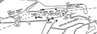
| A110-1 | MARKED WATER TANK APRXLY NINE TENTHS OF A MI EAST OF ARPT, UNMARKED CELL TOWER NEAR WATER TANK & MARKED TRANSMISSION LINE APRXLY 1460 FT EAST OF ARPT. |
| A110-2 | ULTRALIGHT ACTIVITY ON & INVOF ARPT. |
| A110-3 | DEER ON AND IN VICINITY OF AIRPORT. |
| A110-4 | TURF RUNWAY MAY BE SOFT DURING SPRING THAW AND WET PERIODS. CALL FOR CURRENT RUNWAY CONDITIONS. |
| A110-5 | FENCE APRXLY 4 FT HIGH ALONG SOUTH SIDE OF RY 'W' AND EXTDS APRXLY 500 FT INTO THE APRCH SURFACE. |
| A110-6 | RWY E/W 275 FT UNMARKED SAFETY AREA WEST END; 225 FT UNMARKED SAFETY AREA EAST END . |
| A110-7 | RWY E/W WIDTH VARIES 118-178 FT. |
| A110-8 | FOR CD CTC PITTSBURGH APCH AT 412-472-5591 |
| A16 | AIRPORT MANAGER ALTERNATE NUMBER 724-989-6560 |
| A30-E/W | DOGLEG IN RY APRXLY 15 DEGS. |
| A31-E/W | RY E/W 235 FT UNMKD SAFETY AREA WEST END; 281 FT UNMKD SAFETY AREA EAST END. |
| A32-E/W | RY E/W WIDTH VARIES 120-275 FT. |
| A42-E | RY E MKD WITH YELLOW CONES. |
| A42-W | RY W MKD WITH YELLOW CONES. |
| A57-E | CTLNG OBSTN EXCEEDS A 45 DEG SLP. |
| A75 | TIE DOWN ROPES ARE NOT SUPPLIED. |
| E111 | VFR OPNS ONLY |
Runways
Runway Summary
| Runways: | E/W |
| Longest Runway: | E/W is 1800 ft (549 m) long |
| Runways with an Instrument Approach: |
31D Airport Runway Details
| Runway E/W | 1800 ft x 120 ft (549 m x 37 m) | |
| Surface: | Turf - Fair condition - No special surface treatment | |
Runway E |
Runway W |
|
Glide Path Angle: |
0.0 degrees | 0.0 degrees |
Traffic Pattern: |
Left | Left |
Runway Markings Type: |
Nonstandard (other than numbers only) | Nonstandard (other than numbers only) |
Runway Markings Condition: |
Good | Good |
Object at End: |
TREES | TREES |
Object Height: |
74 | 36 |
Distance from End: |
324 | 13 |
Object Centerline Offset: |
151 ft. right of centerline | 116 ft. left of centerline |
Services
Airframe Repair: |
None |
Powerplant Repair: |
None |
Bottled Oxygen: |
None |
Bulk Oxygen: |
None |
Fuel Available: |
100LL |
Landing Fees: |
No |
Parking: |
Tiedowns available |
Maps & Diagrams
31D Sectional
Flight Planning
at skyvector.com
at skyvector.com