Location
Latitude: |
45-59-22.2000N (45.9895) |
Longitude: |
114-50-28.6000W (-114.841278) |
Elevation: |
2634.0 feet MSL (803 m MSL) |
Magnetic Variation: |
12.9 E (as of April 2024 from WMM2020 model) |
Time Zone: |
UTC -8.0 (Standard Time) UTC -7.0 (Daylight Savings Time) |
From City: |
00 N.M. S of Shearer, Idaho |
Found On: |
Great Falls Chart |
FAA Region: |
ANM |
Contacts
Manager: |
Publicly owned: |
| NEZPERCE FOREST AIR OFFICER 104 AIRPORT RD GRANGEVILLE, ID 83530 208-983-9571 |
US FOREST SERVICE 104 AIRPORT RD GRANGEVILLE, ID 83530 208-983-9571 |
Operations
Airport Status: |
Operational |
Facility Use: |
Public |
Type: |
Airport |
Activation Date: |
09/1949 |
Control tower: |
No |
Attendance (Months/Days/Hours): |
Months/Days/Hours Unattended |
Boundary ARTCC: |
ZLC (Salt Lake City) |
Responsible ARTCC: |
ZLC (Salt Lake City) |
Segmented Circle Indicator: |
No |
Traffic Pattern Altitude (MSL): |
3634 feet (1108 m) |
NOTAMs Facility: |
BOI |
NOTAM-D Service: |
Yes |
Military Landing Rights: |
No |
Civil/Military Joint Use: |
No |
Based Aircraft
Annual Operations (as of 08/30/2023)
| Total Operations: | 750 | |
| Air Taxi: | 200 | 26.7% |
| GA Itinerant: | 550 | 73.3% |
Communications
| CTAF: | 122.900 |
Fixed Based Operators (FBOs) & Fuel
(Click on a business for detail)
Please help us keep this information up to date. This is a FREE SERVICE just like everything else on Airport Guide! If you see that a business needs to be added, modified, or deleted please fill out our Update Form.
To add, modify, or delete a business click here.
Please help us keep this information up to date. This is a FREE SERVICE just like everything else on Airport Guide! If you see that a business needs to be added, modified, or deleted please fill out our Update Form.
Area Code: 208 |
| Business Name | Frequency | Phone | Fuel Grade |
|---|
Flight Service Stations
| Primary | Alternate | |
| FSS on Field: | N | |
| FSS Name (ID): | Boise(BOI) | |
| Frequency: | ||
| Toll Free Phone: | 1-800-WX-BRIEF |
Instrument Procedures / Charts
Terminal Procedures are only available for airports in several countries with more being added all the time. If you are looking for a specific country's charts, please send an email to support(at)airportguide.com stating the country name. This will be used to prioritize the implementation.
Navigation Aids (Navaids) near 2U5
| Dist (NM) | ID | Morse Code | Name | Type | Freq | True Hdg | Mag Hdg |
|---|---|---|---|---|---|---|---|
| 63.4 | MSO | _ _ . . . _ _ _ | Missoula | VOR-DME | 112.80 | 29 | 16 |
| 66.2 | LKT | . _ . . _ . _ _ | Salmon | VOR-DME | 113.50 | 151 | 138 |
| 67.8 | IDQ | . . _ . . _ _ . _ | Cottonwood | DME | 115.65 | 274 | 261 |
| 68.8 | INE | . . _ . . | Konna | NDB | 521 | 15 | 2 |
| 87.3 | CPN | _ . _ . . _ _ . _ . | Coppertown | VOR-DME | 116.05 | 87 | 75 |
| 87.5 | MQG | _ _ _ _ . _ _ _ . | Nez Perce | VOR-DME | 114.45 | 286 | 273 |
| 93.2 | DNJ | _ . . _ . . _ _ _ | Donnelly | VOR-DME | 116.20 | 218 | 205 |
| 94.1 | MLP | _ _ . _ . . . _ _ . | Mullan Pass | VOR-DME | 117.80 | 339 | 326 |
Nearby Airports with Fuel
Notices to Airmen (NOTAMS)
Remarks
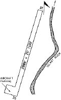
| A110-2 | LCTD IN NARROW WINDING RIVER CANYON. |
| A110-3 | BIG GAME ANIMALS ON & INVOF ARPT. |
| A110-4 | BLIND APCH TO RWY 18; BEFORE LANDING/TAKE-OFF CALL ON FREQ 122.9; MONTR SAME. |
| A110-6 | INEXPERIENCED PILOTS SHOULD USE FOR EMERGENCIES ONLY. RECOMMEND EARLY MORNING OR LATE EVENING OPERATIONS DURING SUMMER. |
| A110-7 | RY MAY BE SOFT IN SPRING AND LATE FALL. |
| A110-8 | FOR CD CTC SALT LAKE ARTCC AT 801-320-2568. |
| A30-18/36 | RECOMMEND LAND RY 18; TKOF RY 36. |
| A33-18/36 | FIRST 300 FT OF RY 18 ROUGH WITH TALL GRASS. |
| E111 | EXISTED PRIOR TO 5/15/59. |
Runways
Runway Summary
| Runways: | 18/36 |
| Longest Runway: | 18/36 is 2000 ft (610 m) long |
| Runways with an Instrument Approach: |
2U5 Airport Runway Details
| Runway 18/36 | 2000 ft x 15 ft (610 m x 5 m) | |
| Surface: | Turf - Fair condition - No special surface treatment | |
Runway 18 |
Runway 36 |
|
Elevation: |
2632.0 | 2591.0 |
Latitude: |
45-59-31.4300N | 45-59-12.9400N |
Longitude: |
114-50-23.6400W | 114-50-33.5700W |
|
Runway True Alignment: |
201 | 021 |
Glide Path Angle: |
0.0 degrees | 0.0 degrees |
Traffic Pattern: |
Left | Left |
Object at End: |
HILL | TREES |
Object Height: |
500 | 85 |
Distance from End: |
1750 | 200 |
Object Centerline Offset: |
0 ft. left and right of centerline | 0 ft. left and right of centerline |
Services
Airframe Repair: |
None |
Powerplant Repair: |
None |
Bottled Oxygen: |
None |
Bulk Oxygen: |
None |
Fuel Available: |
100LL, Jet A+ |
Landing Fees: |
No |
Parking: |
Tiedowns available |
Maps & Diagrams
2U5 Sectional
Flight Planning
at skyvector.com
at skyvector.com