Location
Latitude: |
41-09-05.0000N (41.151389) |
Longitude: |
081-24-54.4000W (-81.415111) |
Elevation: |
1134.4 feet MSL (346 m MSL) |
Magnetic Variation: |
8.5 W (as of April 2024 from WMM2020 model) |
Time Zone: |
UTC -5.0 (Standard Time) UTC -4.0 (Daylight Savings Time) |
From City: |
03 N.M. W of Kent, Ohio |
Found On: |
Detroit Chart |
FAA Region: |
AGL |
Contacts
Manager: |
Publicly owned: |
| DAVID POLUGA 4020 KENT RD STOW, OH 44224-4200 330-672-1943 |
KENT STATE UNIVERSITY 4020 KENT RD STOW, OH 44224-4200 330-672-2640 |
Operations
Airport Status: |
Operational |
Facility Use: |
Public |
Type: |
Airport |
Activation Date: |
01/1938 |
Control tower: |
No |
Attendance (Months/Days/Hours): |
Months/Days/Hours ALL/MON-FRI/0630-DUSK |
Boundary ARTCC: |
ZOB (Cleveland) |
Responsible ARTCC: |
ZOB (Cleveland) |
Lighting Schedule: |
SEE RMK |
Segmented Circle Indicator: |
No |
Traffic Pattern Altitude (MSL): |
2134 feet (650 m) |
NOTAMs Facility: |
CLE |
NOTAM-D Service: |
Yes |
International Airport of Entry: |
No |
Customs Landing Rights: |
No |
Military Landing Rights: |
Yes |
Civil/Military Joint Use: |
No |
Based Aircraft
| Single Engine: | 37 |
| Multi Engine: | 2 |
Annual Operations (as of 08/11/2017)
| Total Operations: | 72500 | |
| Air Taxi: | 1800 | 2.5% |
| GA Local: | 59400 | 81.9% |
| GA Itinerant: | 11100 | 15.3% |
| Military Aircraft: | 200 | 0.3% |
Communications
| CTAF: | 122.725 |
| Unicom: | 122.725 |
| Approach: | CLEVELAND 125.5 125.5 125.5 125.5 125.5 CLEVELAND ARTCC |
| Departure: | CLEVELAND 125.5 125.5 125.5 125.5 125.5 CLEVELAND ARTCC |
| AWOS-2: | 119.15 (330-346-1497) |
- APCH/DEP SVC PRVDD BY CLEVELAND APCH (CLE) 0600-0100. APCH/DEP SVC PRVDD BY CLEVELAND ARTCC (ZOB) ON FREQS 120.6/379.275 (MOUNT HOPE RCAG) 0100-0600.
Fixed Based Operators (FBOs) & Fuel
(Click on a business for detail)
Please help us keep this information up to date. This is a FREE SERVICE just like everything else on Airport Guide! If you see that a business needs to be added, modified, or deleted please fill out our Update Form.
To add, modify, or delete a business click here.
Please help us keep this information up to date. This is a FREE SERVICE just like everything else on Airport Guide! If you see that a business needs to be added, modified, or deleted please fill out our Update Form.
Area Code: 330 |
| Business Name | Frequency | Phone | Fuel Grade |
|---|---|---|---|
| Al Beckwith Leasing Co.
Update FBO info |
688-6666, 686-1234 | ||
| Commercial Aviation Corp.
Update FBO info |
686-1234 | ||
| Kent State University Airport
Update FBO info |
Unicom 122.7 | 672-2640 | 100LL, Jet A |
Flight Service Stations
| Primary | Alternate | |
| FSS on Field: | N | |
| FSS Name (ID): | Cleveland(CLE) | |
| Frequency: | ||
| Toll Free Phone: | 1-800-WX-BRIEF |
Instrument Procedures / Charts
FAA Terminal Procedures valid from 0901Z 03/21/24 to 0901Z 04/18/24.
There are various types of charts available for an airport. They are listed in the Page Type column. Here is a legend for those types:
APD - Airport Diagram
DP - Departure Procedure Charts
HOT - Hot Spots
IAP - Instrument Approach Procedure Charts
MIN - Minimums
STAR - Standard Terminal Arrival Charts
| Page Type | Page Name | Volume | Action Since Last Cycle |
|---|---|---|---|
| IAP | NDB RWY 01 | EC-2 | |
| IAP | RNAV (GPS) RWY 01 | EC-2 | |
| IAP | RNAV (GPS) RWY 19 | EC-2 | |
| IAP | VOR-A | EC-2 | |
| MIN | TAKEOFF MINIMUMS | EC-2 | |
| STAR | BRWNZ FOUR (RNAV) | EC-2 | |
| STAR | BRWNZ FOUR (RNAV)[DELIMITER] CONT.1 | EC-2 | |
| STAR | BRWNZ FOUR (RNAV)[DELIMITER] CONT.2 | EC-2 | |
| STAR | HUUVR ONE (RNAV) | EC-2 | |
| STAR | ZZIPS ONE (RNAV) | EC-2 |
Terminal Procedures are only available for airports in several countries with more being added all the time. If you are looking for a specific country's charts, please send an email to support(at)airportguide.com stating the country name. This will be used to prioritize the implementation.
Navigation Aids (Navaids) near 1G3
| Dist (NM) | ID | Morse Code | Name | Type | Freq | True Hdg | Mag Hdg |
|---|---|---|---|---|---|---|---|
| 5.1 | AK | . _ _ . _ | Akron | NDB | 362 | 165 | 174 |
| 10.0 | ACO | . _ _ . _ . _ _ _ | Akron | VOR-DME | 114.40 | 105 | 114 |
| 14.2 | CAK | _ . _ . . _ _ . _ | Akron/Canton Regional | VOT | 110.60 | 184 | 192 |
| 24.7 | BSV | _ . . . . . . . . . _ | Briggs | VOR-DME | 112.40 | 181 | 189 |
| 24.7 | CXR | _ . _ . _ . . _ . _ . | Chardon | VOR-DME | 112.70 | 27 | 36 |
| 25.3 | CLE | _ . _ . . _ . . . | Cleveland | VOT | 110.40 | 309 | 317 |
| 31.9 | LQL | . _ . . _ _ . _ . _ . . | Lakeland | NDB | 263 | 2 | 11 |
| 35.1 | YNG | _ . _ _ _ . _ _ . | Youngstown | VORTAC | 109.00 | 71 | 80 |
| 35.9 | DJB | _ . . . _ _ _ _ . . . | Dryer | VOR-DME | 113.60 | 290 | 298 |
| 37.1 | YN | _ . _ _ _ . | Fetch | NDB | 338 | 85 | 94 |
| 39.6 | AAU | . _ . _ . . _ | Ashland | NDB | 329 | 253 | 261 |
| 39.9 | HBD | . . . . _ . . . _ . . | Hubbard | NDB | 408 | 89 | 98 |
| 42.1 | MLR | _ _ . _ . . . _ . | Millersburg/Dcmsnd | NDB | 382 | 209 | 217 |
| 45.8 | UCP | . . _ _ . _ . . _ _ . | Castle | NDB | 272 | 99 | 108 |
| 47.3 | JFN | . _ _ _ . . _ . _ . | Jefferson | DME | 115.2 | 39 | 48 |
| 52.1 | MF | _ _ . . _ . | Manns | NDB | 372 | 244 | 252 |
| 55.4 | CTW | _ . _ . _ . _ _ | Newcomerstown | DME | 111.8 | 182 | 190 |
| 55.9 | MFD | _ _ . . _ . _ . . | Mansfield | VORTAC | 108.80 | 252 | 260 |
| 57.8 | CFX | _ . _ . . . _ . _ . . _ | Cadiz | NDB | 239 | 161 | 170 |
| 57.9 | EWC | . . _ _ _ . _ . | Ellwood City | VOR-DME | 115.80 | 109 | 118 |
Nearby Airports with Fuel
Notices to Airmen (NOTAMS)
Remarks
| A11 | AIRPORT@KENT.EDU. |
| A110-1 | OCNL DEER, BIRDS & OTR WILDLIFE ON & INVOF ARPT. |
| A110-2 | FOR NOISE ABATEMENT PROCS CALL AMGR. |
| A110-4 | FOR CD CTC CLEVELAND ARTCC AT 440-774-0223. |
| A110-5 | HVY STUDENT TRG ACT. |
| A13 | ADNL INFO: WWW.KENT.EDU/AIRPORT. |
| A17 | CLSD DEC 25 & JAN 1. |
| A24 | RAMP FEE FOR MULTI-ENG ACFT - WAIVED WITH FUEL PURCHASE. |
| A30A-19 | CALM WIND RWY. |
| A57-01 | APCH RATIO 16:1 TO DTHR DUE TO +122 FT TREE, 1993 FT DIST, 364 FT L. |
| A70-FUEL-10 | 0LL AVBL ONLY WHEN ATNDD, SELF SER UNAVBL. |
| A75 | SUBJ AVBLTY, PRIOR CDN RQRD FOR MULTI-ENG ACFT. |
| A81-APT | ACTVT REIL RWY 01 & 19; VASI RWY 01 & 19; MIRL RWY 01/19 - 122.9. |
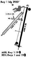
Runways
Runway Summary
| Runways: | 01/19 |
| Longest Runway: | 01/19 is 4000 ft (1219 m) long |
| Runways with an Instrument Approach: |
1G3 Airport Runway Details
| Runway 01/19 | 4000 ft x 60 ft (1219 m x 18 m) | |
| Runway Length Source: | 3RD PARTY SURVEY as of 01/17/2013 | |
| Surface: | Asphalt - Fair condition - No special surface treatment | |
| Runway Edge Lights: | Medium Intensity | |
Runway 01 |
Runway 19 |
|
Elevation: |
1116.4 | 1134.0 |
Latitude: |
41-08-45.4214N | 41-09-24.4997N |
Longitude: |
081-24-58.3277W | 081-24-50.5324W |
|
Runway True Alignment: |
009 | 189 |
Glide Path Angle: |
3.5 degrees | 3.0 degrees |
Traffic Pattern: |
Left | Left |
Runway Markings Type: |
Nonprecision Instrument | Nonprecision Instrument |
Runway Markings Condition: |
Fair | Fair |
Object at End: |
TREES | TREES |
Object Height: |
122 | 88 |
Distance from End: |
1993 | 1586 |
Object Centerline Offset: |
364 ft. left of centerline | 239 ft. right of centerline |
Visual Glide Slope Indicators: |
4-Box VASI On Left Side Of Runway | 4-Box VASI On Left Side Of Runway |
REIL: |
Yes | Yes |
Touchdown Lights: |
No | No |
Centerline Lights: |
No | No |
Threshold Crossing Height: |
42 | 35 |
Threshold Elevation: |
1116.6 | |
Displaced Threshold: |
53 | |
Threshold Latitude: |
41-08-45.9374N | |
Threshold Longitude: |
081-24-58.2248W |
Services
Airframe Repair: |
Minor |
Powerplant Repair: |
Minor |
Fuel Available: |
100LL, Jet A+ |
Landing Fees: |
No |
Parking: |
Hangars and tiedowns available |
Maps & Diagrams
1G3 Sectional
Flight Planning
at skyvector.com
at skyvector.com