Location
Latitude: |
39-46-42.4000N (39.778444) |
Longitude: |
074-56-52.1000W (-74.947806) |
Elevation: |
150.0 feet MSL (46 m MSL) |
Magnetic Variation: |
12 W (as of April 2024 from WMM2020 model) |
Time Zone: |
UTC -5.0 (Standard Time) UTC -4.0 (Daylight Savings Time) |
From City: |
01 N.M. SW of Berlin, New Jersey |
Found On: |
Washington Chart |
FAA Region: |
AEA |
Contacts
Manager: |
Privately owned: |
| KARL KLEINBERG 817 WATSONTOWN RD BERLIN, NJ 08009 856-767-1233 |
ALBION AIRPORT, INC. 817 WATSONTOWN RD. BERLIN, NJ 08009 856-767-1233 |
Operations
Airport Status: |
Operational |
Facility Use: |
Public |
Type: |
Airport |
Activation Date: |
07/1935 |
Control tower: |
No |
Attendance (Months/Days/Hours): |
Months/Days/Hours ALL/ALL/0900-1500 |
Boundary ARTCC: |
ZDC (Washington) |
Responsible ARTCC: |
ZNY (New York) |
Lighting Schedule: |
SEE RMK |
Segmented Circle Indicator: |
No |
Traffic Pattern Altitude (MSL): |
1150 feet (351 m) |
NOTAMs Facility: |
MIV |
NOTAM-D Service: |
Yes |
Based Aircraft
| Single Engine: | 25 |
| Ultralights: | 1 |
Annual Operations (as of 12/31/2022)
| Total Operations: | 5725 | |
| GA Local: | 3600 | 62.9% |
| GA Itinerant: | 2125 | 37.1% |
Communications
| CTAF: | 123.000 |
| Unicom: | 123.000 |
| Approach: | MC GUIRE 126.475 126.475 |
| Departure: | MC GUIRE 126.475 126.475 |
Fixed Based Operators (FBOs) & Fuel
(Click on a business for detail)
Please help us keep this information up to date. This is a FREE SERVICE just like everything else on Airport Guide! If you see that a business needs to be added, modified, or deleted please fill out our Update Form.
To add, modify, or delete a business click here.
Please help us keep this information up to date. This is a FREE SERVICE just like everything else on Airport Guide! If you see that a business needs to be added, modified, or deleted please fill out our Update Form.
Area Code: 609 |
| Business Name | Frequency | Phone | Fuel Grade |
|---|---|---|---|
| Garden State Aviation, Inc.
Update FBO info |
Unicom 123.0 | 767-1233 | 100LL, Jet A |
Flight Service Stations
| Primary | Alternate | |
| FSS on Field: | N | |
| FSS Name (ID): | Millville(MIV) | |
| Frequency: | ||
| Toll Free Phone: | 1-800-WX-BRIEF |
Instrument Procedures / Charts
FAA Terminal Procedures valid from 0901Z 03/21/24 to 0901Z 04/18/24.
There are various types of charts available for an airport. They are listed in the Page Type column. Here is a legend for those types:
APD - Airport Diagram
DP - Departure Procedure Charts
HOT - Hot Spots
IAP - Instrument Approach Procedure Charts
MIN - Minimums
STAR - Standard Terminal Arrival Charts
| Page Type | Page Name | Volume | Action Since Last Cycle |
|---|---|---|---|
| IAP | RNAV (GPS) RWY 05 | NE-2 | |
| IAP | RNAV (GPS) RWY 23 | NE-2 | |
| IAP | VOR-B | NE-2 | |
| MIN | TAKEOFF MINIMUMS | NE-2 |
Terminal Procedures are only available for airports in several countries with more being added all the time. If you are looking for a specific country's charts, please send an email to support(at)airportguide.com stating the country name. This will be used to prioritize the implementation.
Navigation Aids (Navaids) near 19N
| Dist (NM) | ID | Morse Code | Name | Type | Freq | True Hdg | Mag Hdg |
|---|---|---|---|---|---|---|---|
| 14.2 | PHL | . _ _ . . . . . . _ . . | Philadelphia | VOT | 109.80 | 291 | 303 |
| 14.5 | VCN | . . . _ _ . _ . _ . | Cedar Lake | VOR-DME | 115.20 | 183 | 195 |
| 18.4 | PNE | . _ _ . _ . . | North Philadelphia | VOR | 112.00 | 351 | 363 |
| 18.5 | OOD | _ _ _ _ _ _ _ . . | Woodstown | VORTAC | 112.80 | 242 | 254 |
| 21.3 | GXU | _ _ . _ . . _ . . _ | Mc Guire | VORTAC | 110.60 | 49 | 61 |
| 23.3 | RNB | . _ . _ . _ . . . | Rainbow | NDB | 363 | 201 | 213 |
| 23.9 | CYN | _ . _ . _ . _ _ _ . | Coyle | VORTAC | 113.40 | 84 | 96 |
| 25.9 | ACY | . _ _ . _ . _ . _ _ | Atlantic City | VORTAC | 108.60 | 138 | 150 |
| 26.0 | ING | . . _ . _ _ . | Ambler | NDB | 275 | 323 | 335 |
| 28.6 | ARD | . _ . _ . _ . . | Yardley | VOR-DME | 108.20 | 3 | 15 |
| 31.0 | DQO | _ . . _ _ . _ _ _ _ | Dupont | VORTAC | 114.00 | 259 | 271 |
| 31.5 | NEL | _ . . . _ . . | Lakehurst | TACAN | 111.80 | 60 | 72 |
| 32.4 | NEL | _ . . . _ . . | Lakehurst | NDB | 396 | 60 | 72 |
| 32.9 | RBV | . _ . _ . . . . . . _ | Robbinsville | VORTAC | 113.80 | 39 | 51 |
| 33.0 | IL | . . . _ . . | Hadin | NDB | 248 | 249 | 261 |
| 34.3 | MXE | _ _ _ . . _ . | Modena | VORTAC | 113.20 | 284 | 296 |
| 38.7 | PTW | . _ _ . _ . _ _ | Pottstown | VORTAC | 116.50 | 313 | 325 |
| 41.5 | SIE | . . . . . . | Sea Isle | VORTAC | 114.80 | 170 | 182 |
| 42.0 | UKT | . . _ _ . _ _ | Quakertown | NDB | 208 | 337 | 349 |
| 42.1 | ENO | . _ . _ _ _ | Smyrna | VORTAC | 111.40 | 218 | 230 |
Nearby Airports with Fuel
Notices to Airmen (NOTAMS)
Remarks
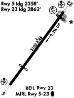
| A110-1 | TREES ALONG NW SIDE OF RWY 05/23. |
| A110-2 | DEER AND GEESE ON AND INVOF ARPT. |
| A110-3 | NON-STANDARD RWY AND TWY LGT SPACING. |
| A110-4 | FOR CD CTC MC GUIRE APCH AT 609-754-2767. |
| A110-5 | TWY LINES & RWY HOLD LNS VERY FADED. |
| A17 | UNATTND CHRISTMAS AND NEW YEARS DAY. |
| A33-05/23 | LRG LONGL CRACK IN MID OF RWY. |
| A43-05 | OTS INDEF. |
| A43-23 | OTS INDEF. |
| A57-05 | +74 FT TREE, DIST 16 FT, 82 FT L, 0:1 BASED ON DSPLCD THLD. |
| A57-23 | +47 FT TREE, DIST 6 FT, 140 FT R, 0:1 BASED ON DSPLCD THLD. |
| A58-05 | +28 FT POLE 7 FT FROM RWY END 74 FT L. |
| A58-23 | +44 FT TREE 37 FT FROM RWY END 206 FT R. |
| A81-APT | ACTVT REIL RWY 05/23; MIRL RWY 05/23 - CTAF. |
| A81-BCN | ACTVT ROTG BCN - CTAF. |
Runways
Runway Summary
| Runways: | 05/23 |
| Longest Runway: | 05/23 is 3094 ft (943 m) long |
| Runways with an Instrument Approach: |
19N Airport Runway Details
| Runway 05/23 | 3094 ft x 45 ft (943 m x 14 m) | |
| Runway Length Source: | 3RD PARTY SURVEY as of 08/21/2008 | |
| Surface: | Asphalt - Good condition - No special surface treatment | |
| Runway Edge Lights: | Medium Intensity | |
Runway 05 |
Runway 23 |
|
Elevation: |
148.9 | 140.7 |
Latitude: |
39-46-30.3115N | 39-46-54.4222N |
Longitude: |
074-57-04.2842W | 074-56-39.9029W |
|
Runway True Alignment: |
038 | 218 |
Glide Path Angle: |
4.0 degrees | 4.0 degrees |
Traffic Pattern: |
Left | Left |
Runway Markings Type: |
Nonprecision Instrument | Nonprecision Instrument |
Runway Markings Condition: |
Good | Good |
Object at End: |
TREES | TREES |
Object Height: |
38 | 78 |
Distance from End: |
211 | 253 |
Object Centerline Offset: |
68 ft. left of centerline | 196 ft. left of centerline |
Visual Glide Slope Indicators: |
Pulsating/Steady Burning VASI On Right Side Of Runway | Pulsating/Steady Burning VASI On Right Side Of Runway |
REIL: |
Yes | Yes |
Threshold Crossing Height: |
23 | 40 |
Threshold Elevation: |
143.6 | 139.9 |
Displaced Threshold: |
740 | 239 |
Threshold Latitude: |
39-46-36.0711N | 39-46-52.5609N |
Threshold Longitude: |
074-56-58.4503W | 074-56-41.7814W |
Services
Airframe Repair: |
None |
Powerplant Repair: |
None |
Bottled Oxygen: |
None |
Bulk Oxygen: |
None |
Fuel Available: |
100LL |
Landing Fees: |
No |
Parking: |
Hangars and tiedowns available |
Maps & Diagrams
19N Sectional
Flight Planning
at skyvector.com
at skyvector.com