Location
Latitude: |
36-35-46.9200N (36.596367) |
Longitude: |
078-33-35.0260W (-78.559729) |
Elevation: |
420.9 feet MSL (128 m MSL) |
Magnetic Variation: |
9.5 W (as of April 2024 from WMM2020 model) |
Time Zone: |
UTC -5.0 (Standard Time) UTC -4.0 (Daylight Savings Time) |
From City: |
02 N.M. S of Clarksville, Virginia |
Found On: |
Washington Chart |
FAA Region: |
AEA |
Contacts
Manager: |
Publicly owned: |
| MICHAEL DENTON LAKE COUNTRY REGIONAL AIRPORT, 11632 HWY 15 CLARKSVILLE, VA 23927 434-374-8028 |
LAKE COUNTRY REG AIRPORT COMMISSION LAKE COUNTRY REGIONAL AIRPORT, POST OFFICE BOX 1047 CLARKSVILLE, VA 23927 434-374-8028 |
Operations
Airport Status: |
Operational |
Facility Use: |
Public |
Type: |
Airport |
Activation Date: |
03/1961 |
Control tower: |
No |
Attendance (Months/Days/Hours): |
Months/Days/Hours ALL/ALL/0800-1700 |
Boundary ARTCC: |
ZDC (Washington) |
Responsible ARTCC: |
ZDC (Washington) |
Lighting Schedule: |
SS-SR |
Segmented Circle Indicator: |
No |
Traffic Pattern Altitude (MSL): |
1421 feet (433 m) |
NOTAMs Facility: |
DCA |
NOTAM-D Service: |
Yes |
International Airport of Entry: |
No |
Customs Landing Rights: |
No |
Military Landing Rights: |
No |
Civil/Military Joint Use: |
No |
Based Aircraft
| Single Engine: | 5 |
Annual Operations (as of 12/31/2021)
| Total Operations: | 5151 | |
| GA Local: | 4373 | 84.9% |
| GA Itinerant: | 624 | 12.1% |
| Military Aircraft: | 154 | 3.0% |
Communications
| CTAF: | 122.900 |
| AWOS-3: | 118.225 (434-374-2431) |
- APCH/DEP SVC PRVDD BY WASHINGTON ARTCC ON FREQS 118.75/377.1 (GREEN BAY RCAG).
Fixed Based Operators (FBOs) & Fuel
(Click on a business for detail)
Please help us keep this information up to date. This is a FREE SERVICE just like everything else on Airport Guide! If you see that a business needs to be added, modified, or deleted please fill out our Update Form.
To add, modify, or delete a business click here.
Please help us keep this information up to date. This is a FREE SERVICE just like everything else on Airport Guide! If you see that a business needs to be added, modified, or deleted please fill out our Update Form.
Area Code: 804 |
| Business Name | Frequency | Phone | Fuel Grade |
|---|---|---|---|
| Lakeside Flight
Website Update FBO info |
Unicom 122.9 | 374-2781 | 100LL |

|
Phillips | 100LL - 2.45 USD per gallon on 8/20/01 |
Self-serve Pumps on request |
Flight Service Stations
| Primary | Alternate | |
| FSS on Field: | N | |
| FSS Name (ID): | Leesburg(DCA) | |
| Frequency: | ||
| Toll Free Phone: | 1-800-WX-BRIEF |
Instrument Procedures / Charts
FAA Terminal Procedures valid from 0901Z 03/21/24 to 0901Z 04/18/24.
There are various types of charts available for an airport. They are listed in the Page Type column. Here is a legend for those types:
APD - Airport Diagram
DP - Departure Procedure Charts
HOT - Hot Spots
IAP - Instrument Approach Procedure Charts
MIN - Minimums
STAR - Standard Terminal Arrival Charts
| Page Type | Page Name | Volume | Action Since Last Cycle |
|---|---|---|---|
| IAP | RNAV (GPS)-A | NE-3 | |
| IAP | RNAV (GPS)-B | NE-3 | |
| MIN | ALTERNATE MINIMUMS | NE-3 | |
| MIN | TAKEOFF MINIMUMS | NE-3 |
Terminal Procedures are only available for airports in several countries with more being added all the time. If you are looking for a specific country's charts, please send an email to support(at)airportguide.com stating the country name. This will be used to prioritize the implementation.
Navigation Aids (Navaids) near W63
| Dist (NM) | ID | Morse Code | Name | Type | Freq | True Hdg | Mag Hdg |
|---|---|---|---|---|---|---|---|
| 17.9 | HXO | . . . . _ . . _ _ _ _ | Huntsboro | NDB | 271 | 189 | 199 |
| 22.4 | SBV | . . . _ . . . . . . _ | South Boston | VORTAC | 110.40 | 282 | 291 |
| 24.4 | AEA | . _ . . _ | Jones | NDB | 373 | 87 | 97 |
| 24.9 | MBV | _ _ _ . . . . . . _ | Mecklenburg/Dcmsnd | NDB | 356 | 76 | 86 |
| 32.7 | HUR | . . . . . . _ . _ . | Person | NDB | 220 | 228 | 237 |
| 34.3 | LVL | . _ . . . . . _ . _ . . | Lawrenceville | VORTAC | 112.90 | 66 | 76 |
| 37.5 | DAN | _ . . . _ _ . | Danville | VOR | 113.10 | 267 | 276 |
| 40.3 | BKT | _ . . . _ . _ _ | Blackstone | NDB | 326 | 37 | 47 |
| 40.9 | LE | . _ . . . | Leevy | NDB | 350 | 191 | 200 |
| 42.1 | RZZ | . _ . _ _ . . _ _ . . | Rapids | NDB | 407 | 102 | 112 |
| 44.8 | RDU | . _ . _ . . . . _ | Raleigh/Durham | VORTAC | 117.20 | 194 | 203 |
| 45.8 | FVX | . . _ . . . . _ _ . . _ | Farmville | NDB | 367 | 7 | 17 |
| 51.1 | LYH | . _ . . _ . _ _ . . . . | Lynchburg | VOR-DME | 109.20 | 320 | 329 |
| 51.7 | LY | . _ . . _ . _ _ | Bojar | NDB | 385 | 320 | 329 |
| 54.6 | ELQ | . . _ . . _ _ . _ | Emporia | NDB | 261 | 88 | 98 |
| 55.6 | TYI | _ _ . _ _ . . | Tar River | VORTAC | 117.80 | 131 | 141 |
| 59.4 | SIF | . . . . . . . _ . | Slammer | NDB | 423 | 257 | 266 |
| 61.9 | HB | . . . . _ . . . | Alamm | NDB | 361 | 233 | 242 |
| 62.1 | OQA | _ _ _ _ _ . _ . _ | Rockingham County | FAN MARKER | 260 | 269 | |
| 63.1 | ETC | . _ _ . _ . | Tarboro | NDB | 257 | 128 | 138 |
Nearby Airports with Fuel
Notices to Airmen (NOTAMS)
Remarks
| A110-1 | WILDLIFE INVOF ARPT. |
| A110-2 | SELF SVC FUEL AVBL. |
| A110-4 | FOR CD CTC WASHINGTON ARTCC AT 703-771-3587. |
| A57-22 | RYW 22 APCH SLOPE 15:1 TO DSPLCD THR FROM 82 FT TREE 1502 FT FR DSPLCD THR, 142 FT L. |
| A58-04 | CLOSE-IN OBSTRUCTION, 15 FT ABOVE RWY SURFACE, 64 FT FROM THR, 178 FT RIGHT OF CENTERLINE ON APPROACH. |
| A58-22 | ROAD CROSSING 170 FT FROM END OF RWY. BUILDING 27 FT, 90 FT FROM END OF RWY, 110 FT L. |
Runways
Runway Summary
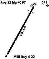
| Runways: | 04/22 |
| Longest Runway: | 04/22 is 4007 ft (1221 m) long |
| Runways with an Instrument Approach: |
W63 Airport Runway Details
| Runway 04/22 | 4007 ft x 50 ft (1221 m x 15 m) | |
| Runway Length Source: | OWNER as of 09/08/2023 | |
| Surface: | Asphalt - Excellent condition - No special surface treatment | |
| Runway Edge Lights: | Medium Intensity | |
Runway Weight Bearing Capacity (in thousands of pounds) |
||
| Single Wheel Landing Gear: | 12.5 | |
Runway 04 |
Runway 22 |
|
Elevation: |
373.7 | 411.8 |
Latitude: |
36-35-29.3800N | 36-36-04.4600N |
Longitude: |
078-33-46.4400W | 078-33-23.6100W |
|
Runway True Alignment: |
028 | 208 |
Glide Path Angle: |
0.0 degrees | 0.0 degrees |
Traffic Pattern: |
Left | Left |
Runway Markings Type: |
Nonprecision Instrument | Basic |
Runway Markings Condition: |
Good | Good |
Object at End: |
TREE | ROAD |
Object Height: |
37 | 18 |
Distance from End: |
601 | 200 |
Object Centerline Offset: |
272 ft. left of centerline | 0 ft. left and right of centerline |
Threshold Elevation: |
411.8 | |
Displaced Threshold: |
480 | |
Threshold Latitude: |
36-36-00.2260N | |
Threshold Longitude: |
078-33-26.3500W |
Services
Airframe Repair: |
Major |
Powerplant Repair: |
Major |
Bottled Oxygen: |
High Pressure / Low Pressure |
Bulk Oxygen: |
None |
Fuel Available: |
100LL, Jet A-1+ |
Landing Fees: |
No |
Parking: |
Hangars and tiedowns available |
Maps & Diagrams
W63 Sectional
Flight Planning
at skyvector.com
at skyvector.com