Location
Latitude: |
31-03-28.2000N (31.057833) |
Longitude: |
104-47-01.7000W (-104.783806) |
Elevation: |
3956.8 feet MSL (1206 m MSL) |
Magnetic Variation: |
6.7 E (as of April 2024 from WMM2020 model) |
Time Zone: |
UTC -6.0 (Standard Time) UTC -5.0 (Daylight Savings Time) |
From City: |
03 N.M. NE of Van Horn, Texas |
Found On: |
El Paso Chart |
FAA Region: |
ASW |
Contacts
Manager: |
Publicly owned: |
| LARRY SIMPSON BOX 1060 VAN HORN, TX 79855 432-283-2920 |
CULBERSON COUNTY PO BOX 927 VAN HORN, TX 79855 915-283-2794 |
Operations
Airport Status: |
Operational |
Facility Use: |
Public |
Type: |
Airport |
Activation Date: |
11/1943 |
Control tower: |
No |
Attendance (Months/Days/Hours): |
Months/Days/Hours ALL/ALL/0900-1800 |
Boundary ARTCC: |
ZAB (Albuquerque) |
Responsible ARTCC: |
ZAB (Albuquerque) |
Lighting Schedule: |
SEE RMK |
Segmented Circle Indicator: |
Yes |
Traffic Pattern Altitude (MSL): |
4957 feet (1511 m) |
NOTAMs Facility: |
ABQ |
NOTAM-D Service: |
Yes |
International Airport of Entry: |
No |
Customs Landing Rights: |
No |
Military Landing Rights: |
Yes |
Civil/Military Joint Use: |
No |
Based Aircraft
| Single Engine: | 1 |
Annual Operations (as of 05/22/2018)
| Total Operations: | 3480 | |
| GA Local: | 120 | 3.4% |
| GA Itinerant: | 3000 | 86.2% |
| Military Aircraft: | 360 | 10.3% |
Communications
| CTAF: | 122.900 |
| AWOS-3PT: | 119.925 (432-283-2418) |
- APCH/DEP SVC PRVDD BY ALBUQUERQUE ARTCC (ABQ) ON FREQS 135.875/292.15 (EL PASO/A/ RCAG).
Fixed Based Operators (FBOs) & Fuel
(Click on a business for detail)
Please help us keep this information up to date. This is a FREE SERVICE just like everything else on Airport Guide! If you see that a business needs to be added, modified, or deleted please fill out our Update Form.
To add, modify, or delete a business click here.
Please help us keep this information up to date. This is a FREE SERVICE just like everything else on Airport Guide! If you see that a business needs to be added, modified, or deleted please fill out our Update Form.
Area Code: 915 |
| Business Name | Frequency | Phone | Fuel Grade |
|---|---|---|---|
| Van Horn Aviation Service
Update FBO info |
Unicom 122.8 | 283-2237 | 100LL, Jet A |
Flight Service Stations
| Primary | Alternate | |
| FSS on Field: | N | |
| FSS Name (ID): | Albuquerque(ABQ) | |
| Frequency: | ||
| Toll Free Phone: | 1-800-WX-BRIEF |
Instrument Procedures / Charts
FAA Terminal Procedures valid from 0901Z 03/21/24 to 0901Z 04/18/24.
There are various types of charts available for an airport. They are listed in the Page Type column. Here is a legend for those types:
APD - Airport Diagram
DP - Departure Procedure Charts
HOT - Hot Spots
IAP - Instrument Approach Procedure Charts
MIN - Minimums
STAR - Standard Terminal Arrival Charts
| Page Type | Page Name | Volume | Action Since Last Cycle |
|---|---|---|---|
| IAP | RNAV (GPS) RWY 21 | SC-3 | |
| MIN | ALTERNATE MINIMUMS | SC-3 | |
| MIN | TAKEOFF MINIMUMS | SC-3 |
Terminal Procedures are only available for airports in several countries with more being added all the time. If you are looking for a specific country's charts, please send an email to support(at)airportguide.com stating the country name. This will be used to prioritize the implementation.
Navigation Aids (Navaids) near VHN
| Dist (NM) | ID | Morse Code | Name | Type | Freq | True Hdg | Mag Hdg |
|---|---|---|---|---|---|---|---|
| 0.3 | VHN | . . . _ . . . . _ . | Van Horn | NDB | 233 | 327 | 320 |
| 29.8 | XAA | _ . . _ . _ . _ | Kent | NDB | 225 | 94 | 87 |
| 43.2 | HUP | . . . . . . _ . _ _ . | Hudspeth | VORTAC | 115.00 | 315 | 308 |
| 44.2 | SFL | . . . . . _ . . _ . . | Salt Flat | VORTAC | 113.00 | 339 | 332 |
| 62.5 | MRF | _ _ . _ . . . _ . | Marfa | VOR-DME | 115.90 | 136 | 130 |
| 66.7 | PEQ | . _ _ . . _ _ . _ | Pecos | VOR-DME | 116.50 | 67 | 61 |
| 68.8 | BWR | _ . . . . _ _ . _ . | Brewster County | NDB | 412 | 121 | 115 |
| 76.0 | CV | _ . _ . . . . _ | Carlz | NDB | 402 | 17 | 10 |
| 77.4 | CNM | _ . _ . _ . _ _ | Carlsbad | VORTAC | 116.30 | 21 | 14 |
| 89.2 | ELP | . . _ . . . _ _ . | El Paso | VORTAC | 115.20 | 301 | 294 |
| 91.1 | CJS | _ . _ . . _ _ _ . . . | Ciudad Juarez | VOR-DME | 116.70 | 292 | 285 |
| 91.1 | CJS | Juarez | VOR-DME | 116.70 | 292 | 285 | |
| 92.1 | EL | . . _ . . | Valtr | NDB | 242 | 301 | 294 |
| 92.2 | PIO | . _ _ . . . _ _ _ | Pinon | VOR-DME | 110.40 | 343 | 336 |
| 92.6 | ELP | . . _ . . . _ _ . | El Paso | VOT | 111.00 | 299 | 292 |
| 92.8 | INK | . . _ . _ . _ | Wink | VORTAC | 112.10 | 57 | 51 |
| 93.0 | IMP | . . _ _ . _ _ . | Marathon | NDB | 388 | 120 | 114 |
| 93.1 | EWM | . . _ _ _ _ | Newman | VORTAC | 112.40 | 305 | 298 |
| 93.2 | FST | . . _ . . . . _ | Fort Stockton | VORTAC | 116.90 | 93 | 87 |
Nearby Airports with Fuel
| Dist (NM) | Name (Airport IDs) | True Hdg | Mag Hdg | Fuel Grade |
|---|---|---|---|---|
| 57.1 | Marfa Municipal Airport (MRF KMRF MRF) |
135 | 129 | 100LL, Jet A |
| 68.2 | Pecos Municipal Airport (PEQ KPEQ PEQ) |
73 | 67 | 100LL, Jet A-1+ |
| 69.7 | Alpine-Casparis Municipal Airport (ALE E38) |
125 | 119 | 100LL, Jet A, Jet A-1+ |
| 75.1 | Fabens Airport (E35) |
291 | 284 | 100LL |
| 81.2 | Cavern City Air Trml Airport (CNM KCNM CNM) |
18 | 11 | 100LL, Jet A-1+ |
| 88.2 | Presidio Lely International Airport (KPRS PRS) |
165 | 159 | 100LL, Jet A |
| 91.9 | Winkler County Airport (INK KINK INK) |
61 | 55 | 100LL, Jet A+ |
| 93.1 | El Paso International Airport (ELP KELP ELP) |
299 | 292 | 100LL, Jet A-1+ |
| 96.6 | Fort Stockton-Pecos County Airport (FST KFST FST) |
94 | 88 | 100LL, Jet A+ |
Notices to Airmen (NOTAMS)
Remarks
| A110-1 | FOR CD CTC ALBUQUERQUE ARTCC AT 505-856-4861. |
| A40-03/21 | RWY 21 HAS NSTD LENSES. NORTH SIDE HAS SPLIT CLEAR/AMBER. SOUTH SIDE HAS CLEAR LENSES. |
| A42-07 | PAINT MARKINGS FADED. |
| A42-25 | PAINT MARKINGS FADED. |
| A58-21 | SCATTERED 10 FT BRUSH FM THR TO 200 FT FM THR 138 FT LEFT AND 132 FT RIGHT. |
| A58-25 | SCATTERED 5 FT BRUSH FM THR TO 200 FT FM THR 171 FT RIGHT AND 156 FT LEFT. |
| A70-FUEL-10 | 0LL FOR FUEL CALL 432-283-2237 OR 432-284-1418. |
| A81-APT | ACTVT PAPI RWY 03 & 21 - CTAF. |
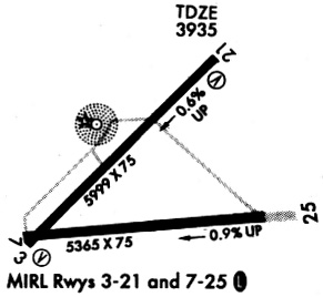
Runways
Runway Summary
| Runways: | 03/21 07/25 |
| Longest Runway: | 03/21 is 6005 ft (1830 m) long |
| Runways with an Instrument Approach: |
VHN Airport Runway Details
| Runway 03/21 | 6005 ft x 76 ft (1830 m x 23 m) | |
| Runway Length Source: | 3RD PARTY SURVEY as of 09/10/2011 | |
| Surface: | Asphalt - Good condition - No special surface treatment | |
| Runway Edge Lights: | Medium Intensity | |
Runway Weight Bearing Capacity (in thousands of pounds) |
||
| Single Wheel Landing Gear: | 15.0 | |
Runway 03 |
Runway 21 |
|
Elevation: |
3956.0 | 3918.3 |
Latitude: |
31-03-15.0393N | 31-03-57.4146N |
Longitude: |
104-47-28.5473W | 104-46-40.1580W |
|
Runway True Alignment: |
045 | 225 |
Glide Path Angle: |
3.0 degrees | 3.0 degrees |
Traffic Pattern: |
Left | Left |
Runway Markings Type: |
Nonprecision Instrument | Nonprecision Instrument |
Runway Markings Condition: |
Good | Good |
Object at End: |
BRUSH | BRUSH |
Object Height: |
10 | 10 |
Distance from End: |
200 | 200 |
Object Centerline Offset: |
250 ft. left of centerline | 126 ft. right of centerline |
Visual Glide Slope Indicators: |
2-Light PAPI On Left Side Of Runway | 2-Light PAPI On Left Side Of Runway |
Threshold Crossing Height: |
45 | 44 |
| Runway 07/25 | 5353 ft x 75 ft (1632 m x 23 m) | |
| Runway Length Source: | 3RD PARTY SURVEY as of 09/10/2011 | |
| Surface: | Asphalt - Good condition - No special surface treatment | |
| Runway Edge Lights: | Medium Intensity | |
Runway Weight Bearing Capacity (in thousands of pounds) |
||
| Single Wheel Landing Gear: | 15.0 | |
Runway 07 |
Runway 25 |
|
Elevation: |
3956.8 | 3910.7 |
Latitude: |
31-03-16.6099N | 31-03-21.7615N |
Longitude: |
104-47-29.3616W | 104-46-28.1259W |
|
Runway True Alignment: |
084 | 264 |
Glide Path Angle: |
0.0 degrees | 0.0 degrees |
Traffic Pattern: |
Left | Left |
Runway Markings Type: |
Basic | Basic |
Runway Markings Condition: |
Poor | Poor |
Object at End: |
BRUSH | BRUSH |
Object Height: |
10 | 5 |
Distance from End: |
269 | 200 |
Object Centerline Offset: |
250 ft. left of centerline | 126 ft. right of centerline |
Services
Bottled Oxygen: |
None |
Fuel Available: |
100LL, Jet A+ |
Landing Fees: |
No |
Parking: |
Hangars and tiedowns available |
Maps & Diagrams
VHN Sectional
Flight Planning
at skyvector.com
at skyvector.com