Location
Latitude: |
33-27-13.3790N (33.453716) |
Longitude: |
093-59-27.7100W (-93.991031) |
Elevation: |
389.7 feet MSL (119 m MSL) |
Magnetic Variation: |
0.9 E (as of April 2024 from WMM2020 model) |
Time Zone: |
UTC -6.0 (Standard Time) UTC -5.0 (Daylight Savings Time) |
From City: |
03 N.M. NE of Texarkana, Arkansas |
Found On: |
Memphis Chart |
FAA Region: |
ASW |
Contacts
Manager: |
Publicly owned: |
| FERDINAND PAUL MEHRLICH III, CM ACE 201 AIRPORT DR TEXARKANA, AR 71854 870-774-2171 |
TEXARKANA AIRPORT AUTHORITY 201 AIRPORT DR TEXARKANA, AR 71854 870-774-2171 |
Operations
Airport Status: |
Operational |
Facility Use: |
Public |
Type: |
Airport |
Activation Date: |
04/1940 |
Control tower: |
Yes |
Attendance (Months/Days/Hours): |
Months/Days/Hours ALL/ALL/0600-2200 |
Boundary ARTCC: |
ZFW (Fort Worth) |
Responsible ARTCC: |
ZFW (Fort Worth) |
Lighting Schedule: |
SEE RMK |
Segmented Circle Indicator: |
Yes |
Traffic Pattern Altitude (MSL): |
1390 feet (424 m) |
NOTAMs Facility: |
TXK |
NOTAM-D Service: |
Yes |
International Airport of Entry: |
No |
Customs Landing Rights: |
No |
Military Landing Rights: |
Yes |
Civil/Military Joint Use: |
No |
Aircraft Rescue and Firefighting: |
Class I ARFF Index: A Air Carrier Service: Scheduled Certification Date: 05/1973 |
Based Aircraft
| Single Engine: | 31 |
| Multi Engine: | 7 |
| Jet Engine: | 10 |
| GA Helicopters: | 4 |
Annual Operations (as of 12/31/2019)
| Total Operations: | 32598 | |
| Commercial: | 21 | 0.1% |
| Air Taxi: | 4978 | 15.3% |
| GA Local: | 14006 | 43.0% |
| GA Itinerant: | 11317 | 34.7% |
| Military Aircraft: | 2276 | 7.0% |
Communications
| CTAF: | 123.875 |
| Tower: | TEXARKANA 123.875 235.625 Hrs: 0600-2200 |
| Ground: | 119.225 |
| Approach: | FORT WORTH ARTCC |
| Departure: | FORT WORTH ARTCC |
| ATIS: | 120.2 Hrs: 24 |
| ASOS: | 120.2 (870-774-0404) |
| EMERG: | 121.5 |
| EMERG: | 243.0 |
- APCH/DEP CTL SVC PRVDD BY FORT WORTH ARTCC (ZFW) ON FREQS 123.925/269.475 (TEXARKANA RCAG).
- ATCT OPERATED BY ROBERTSON VAN BUREN ASSOCIATE INC.
Fixed Based Operators (FBOs) & Fuel
(Click on a business for detail)
Please help us keep this information up to date. This is a FREE SERVICE just like everything else on Airport Guide! If you see that a business needs to be added, modified, or deleted please fill out our Update Form.
To add, modify, or delete a business click here.
Please help us keep this information up to date. This is a FREE SERVICE just like everything else on Airport Guide! If you see that a business needs to be added, modified, or deleted please fill out our Update Form.
Area Code: 870 |
| Business Name | Frequency | Phone | Fuel Grade |
|---|---|---|---|
| TAC Air
Update FBO info |
Unicom 122.95 | 773-6969 | 100LL, Jet A |
Flight Service Stations
| Primary | Alternate | |
| FSS on Field: | N | |
| FSS Name (ID): | Jonesboro(JBR) | |
| Frequency: | ||
| Toll Free Phone: | 1-800-WX-BRIEF |
Instrument Procedures / Charts
FAA Terminal Procedures valid from 0901Z 03/21/24 to 0901Z 04/18/24.
There are various types of charts available for an airport. They are listed in the Page Type column. Here is a legend for those types:
APD - Airport Diagram
DP - Departure Procedure Charts
HOT - Hot Spots
IAP - Instrument Approach Procedure Charts
MIN - Minimums
STAR - Standard Terminal Arrival Charts
| Page Type | Page Name | Volume | Action Since Last Cycle |
|---|---|---|---|
| APD | AIRPORT DIAGRAM | SC-1 | |
| IAP | ILS OR LOC RWY 22 | SC-1 | Changed |
| IAP | RNAV (GPS) RWY 04 | SC-1 | Changed |
| IAP | RNAV (GPS) RWY 13 | SC-1 | Changed |
| IAP | RNAV (GPS) RWY 22 | SC-1 | Changed |
| IAP | RNAV (GPS) RWY 31 | SC-1 | Changed |
| IAP | VOR RWY 13 | SC-1 | Changed |
| MIN | ALTERNATE MINIMUMS | SC-1 | |
| MIN | TAKEOFF MINIMUMS | SC-1 |
Terminal Procedures are only available for airports in several countries with more being added all the time. If you are looking for a specific country's charts, please send an email to support(at)airportguide.com stating the country name. This will be used to prioritize the implementation.
Navigation Aids (Navaids) near TXK
| Dist (NM) | ID | Morse Code | Name | Type | Freq | True Hdg | Mag Hdg |
|---|---|---|---|---|---|---|---|
| 5.5 | TXK | _ _ . . _ _ . _ | Texarkana | VORTAC | 116.30 | 311 | 310 |
| 6.0 | TX | _ _ . . _ | Tecco | NDB | 234 | 45 | 44 |
| 23.2 | ATA | . _ _ . _ | Atlanta | NDB | 347 | 205 | 204 |
| 23.3 | HPC | . . . . . _ _ . _ . _ . | Hope | NDB | 362 | 46 | 45 |
| 35.7 | VIV | . . . _ . . . . . _ | Vivian | NDB | 284 | 181 | 180 |
| 41.9 | EIC | . . . _ . _ . | Belcher | VORTAC | 117.40 | 167 | 166 |
| 56.3 | DTN | _ . . _ _ . | Downtown | VOR | 108.60 | 167 | 166 |
| 57.1 | ADF | . _ _ . . . . _ . | Arkadelphia | NDB | 275 | 50 | 49 |
| 59.3 | BAD | _ . . . . _ _ . . | Barksdale | TACAN | 115.80 | 163 | 162 |
| 60.9 | SHV | . . . . . . . . . . _ | Shreveport | VOT | 108.20 | 172 | 171 |
| 63.6 | ELD | . . _ . . _ . . | El Dorado | VOR-DME | 115.50 | 100 | 100 |
| 64.1 | EL | . . _ . . | Lados | NDB | 418 | 98 | 98 |
| 65.2 | VM | . . . _ _ _ | Fench | NDB | 352 | 356 | 355 |
| 66.3 | EMG | . _ _ _ _ . | Elm Grove | VORTAC | 111.20 | 162 | 161 |
| 70.5 | HO | . . . . _ _ _ | Hossy | NDB | 385 | 34 | 33 |
| 72.4 | GG | _ _ . _ _ . | Veels | NDB | 410 | 214 | 213 |
| 73.0 | GGG | _ _ . _ _ . _ _ . | Gregg County | VORTAC | 112.90 | 211 | 210 |
| 73.1 | PRX | . _ _ . . _ . _ . . _ | Paris | VOR-DME | 113.60 | 274 | 273 |
| 76.1 | HOT | . . . . _ _ _ _ | Hot Springs | VOR-DME | 110.00 | 35 | 34 |
| 76.8 | ABG | . _ _ . . . _ _ . | Ambassador | NDB | 404 | 227 | 226 |
Nearby Airports with Fuel
Notices to Airmen (NOTAMS)
Remarks
| A11 | FERDINAND MEHRLICH |
| A110-1 | DEER ON & INVOF ARPT. |
| A110-2 | FOR CD IF UNA TO CTC ON FSS FREQ, CTC FORT WORTH ARTCC AT 817-858-7584. |
| A110-3 | BIRDS ON & INVOF ARPT. |
| A57-13 | +55 FT TREE 1215 FT 475 FT LEFT. APCH RATIO 22:1 BASED ON DSPLCD THR. |
| A81-APT | WHEN ATCT CLSD ACTVT MALSR RWY 22; HIRL RWY 04/22; MIRL RWY 13/31 - CTAF. |
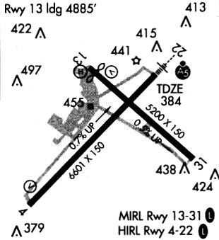
Runways
Runway Summary
| Runways: | 04/22 13/31 |
| Longest Runway: | 04/22 is 6602 ft (2012 m) long |
| Runways with an Instrument Approach: | 22 |
TXK Airport Runway Details
| Runway 04/22 | 6602 ft x 150 ft (2012 m x 46 m) | |
| Runway Length Source: | 3RD PARTY SURVEY as of 08/14/2020 | |
| Surface: | Asphalt - Good condition - Saw-cut or plastic grooved | |
| Runway Edge Lights: | High Intensity | |
Runway Weight Bearing Capacity (in thousands of pounds) |
||
| Single Wheel Landing Gear: | 50.0 | |
| Dual Wheel Landing Gear: | 86.0 | |
| Dual Tandem Wheel Landing Gear: | 120.0 | |
Runway 04 |
Runway 22 |
|
Elevation: |
338.4 | 384.3 |
Latitude: |
33-26-46.5070N | 33-27-32.7086N |
Longitude: |
094-00-04.8813W | 093-59-09.8171W |
|
Runway True Alignment: |
045 | 225 |
ILS Type: |
ILS/DME | |
Glide Path Angle: |
3.0 degrees | 0.0 degrees |
Traffic Pattern: |
Left | Left |
Runway Markings Type: |
Precision Instrument | Precision Instrument |
Runway Markings Condition: |
Good | Good |
Object at End: |
TREES | TREES |
Object Height: |
31 | 17 |
Distance from End: |
263 | 358 |
Object Centerline Offset: |
505 ft. left of centerline | 511 ft. left of centerline |
Visual Glide Slope Indicators: |
4-Box VASI On Left Side Of Runway | |
Approach Light System: |
1,400 Foot Medium Intensity Approach Lighting System With Runway Alignment Indicator Lights | |
Threshold Crossing Height: |
52 | |
Declared Distances |
||
Take Off Run Avbl. (TORA): |
6602 | 6602 |
Take Off Distance Avbl. (TODA): |
6602 | 6602 |
Actual Stop Dist. Avbl. (ASDA): |
6602 | 6602 |
Landing Dist. Avbl. (LDA): |
6602 | 6602 |
| Runway 13/31 | 5200 ft x 100 ft (1585 m x 30 m) | |
| Runway Length Source: | 3RD PARTY SURVEY as of 08/14/2020 | |
| Surface: | Asphalt - Good condition - Saw-cut or plastic grooved | |
| Runway Edge Lights: | Medium Intensity | |
Runway Weight Bearing Capacity (in thousands of pounds) |
||
| Single Wheel Landing Gear: | 25.0 | |
Runway 13 |
Runway 31 |
|
Elevation: |
360.7 | 385.6 |
Latitude: |
33-27-36.3475N | 33-26-59.9808N |
Longitude: |
093-59-37.1693W | 093-58-53.7693W |
|
Runway True Alignment: |
135 | 315 |
Glide Path Angle: |
3.0 degrees | 0.0 degrees |
Traffic Pattern: |
Left | Left |
Runway Markings Type: |
Nonprecision Instrument | Nonprecision Instrument |
Runway Markings Condition: |
Good | Good |
Object at End: |
RR | TREE |
Object Height: |
15 | 40 |
Distance from End: |
350 | 750 |
Object Centerline Offset: |
505 ft. left of centerline | 511 ft. left of centerline |
Visual Glide Slope Indicators: |
4-Light PAPI On Left Side Of Runway | |
Threshold Crossing Height: |
48 | |
Threshold Elevation: |
365.9 | |
Displaced Threshold: |
641 | |
Threshold Latitude: |
33-27-31.8659N | |
Threshold Longitude: |
093-59-31.8194W | |
Declared Distances |
||
Take Off Run Avbl. (TORA): |
5200 | 5200 |
Take Off Distance Avbl. (TODA): |
5200 | 5200 |
Actual Stop Dist. Avbl. (ASDA): |
5200 | 4559 |
Landing Dist. Avbl. (LDA): |
4559 | 4559 |
Services
Airframe Repair: |
Major |
Powerplant Repair: |
Major |
Fuel Available: |
100LL, Jet A |
Landing Fees: |
No |
Parking: |
Hangars and tiedowns available |
Maps & Diagrams
TXK Sectional
Flight Planning
at skyvector.com
at skyvector.com