Location
Latitude: |
33-48-12.1783N (33.803383) |
Longitude: |
118-20-22.5875W (-118.339608) |
Elevation: |
103.2 feet MSL (31 m MSL) |
Magnetic Variation: |
11.5 E (as of April 2024 from WMM2020 model) |
Time Zone: |
UTC -8.0 (Standard Time) UTC -7.0 (Daylight Savings Time) |
From City: |
03 N.M. SW of Torrance, California |
Found On: |
Los Angeles Chart |
FAA Region: |
AWP |
Contacts
Manager: |
Publicly owned: |
| RAFAEL HERRERA CITY OF TORRANCE, 3301 AIRPORT DRIVE TORRANCE, CA 90505 310-784-7914 |
CITY OF TORRANCE 3031 TORRANCE BLVD TORRANCE, CA 90503 310-784-7900 |
Operations
Airport Status: |
Operational |
Facility Use: |
Public |
Type: |
Airport |
Control tower: |
Yes |
Attendance (Months/Days/Hours): |
Months/Days/Hours ALL/ALL/0600-2200 |
Boundary ARTCC: |
ZLA (Los Angeles) |
Responsible ARTCC: |
ZLA (Los Angeles) |
Lighting Schedule: |
SEE RMK |
Segmented Circle Indicator: |
Yes |
Traffic Pattern Altitude (MSL): |
1103 feet (336 m) |
NOTAMs Facility: |
TOA |
NOTAM-D Service: |
Yes |
International Airport of Entry: |
No |
Customs Landing Rights: |
No |
Military Landing Rights: |
Yes |
Civil/Military Joint Use: |
No |
Based Aircraft
| Single Engine: | 210 |
| Multi Engine: | 21 |
| Jet Engine: | 2 |
| GA Helicopters: | 3 |
| Gliders: | 3 |
Annual Operations (as of 01/31/2016)
| Total Operations: | 119034 | |
| Commercial: | 28 | 0.0% |
| Air Taxi: | 348 | 0.3% |
| GA Local: | 55144 | 46.3% |
| GA Itinerant: | 63040 | 53.0% |
| Military Aircraft: | 474 | 0.4% |
Communications
| CTAF: | 124.000 |
| Unicom: | 122.950 |
| Tower: | TORRANCE 124.0 ;SOUTH 133.075 ;NORTH 257.8 Hrs: 0700-2000 |
| Ground: | 120.9 |
| Approach: | SOCAL |
| Departure: | SOCAL |
| ATIS: | 125.6 Hrs: 24 |
- TWR SECTORIZATION IS BASED ON CENTER OF ARPT PARALLEL TO RY 11/29 CNTRLN.
Fixed Based Operators (FBOs) & Fuel
(Click on a business for detail)
Please help us keep this information up to date. This is a FREE SERVICE just like everything else on Airport Guide! If you see that a business needs to be added, modified, or deleted please fill out our Update Form.
To add, modify, or delete a business click here.
Please help us keep this information up to date. This is a FREE SERVICE just like everything else on Airport Guide! If you see that a business needs to be added, modified, or deleted please fill out our Update Form.
Area Code: 310 |
| Business Name | Frequency | Phone | Fuel Grade |
|---|---|---|---|
| Acme Aircraft
Update FBO info |
326-4081 | ||
| Alexair Helicopters
Update FBO info |
326-3338 | ||
| Baker Aero Electric
Update FBO info |
539-9789 | ||
| Benbow Aviation
Update FBO info |
325-4622 | ||
| Benbow Maintenance
Update FBO info |
325-9074 | ||
| Chuck Smith Associates
Update FBO info |
325-0131 | ||
| Great American Aviation
Update FBO info |
Unicom 122.95 | 534-2333 | 100LL |
| Robinson Helicopter Company
Update FBO info |
539-0508 | ||
| Rolling Hills Aviation
Update FBO info |
Unicom 122.95 | 326-3213 | |
| South Bay Aviation
Update FBO info |
Unicom 122.95 | 326-8053 | 100LL |
| Southwest Flight Center
Update FBO info |
326-7982 |
Flight Service Stations
| Primary | Alternate | |
| FSS on Field: | N | |
| FSS Name (ID): | Hawthorne(HHR) | |
| Frequency: | ||
| Toll Free Phone: | 1-800-WX-BRIEF |
Instrument Procedures / Charts
FAA Terminal Procedures valid from 0901Z 03/21/24 to 0901Z 04/18/24.
There are various types of charts available for an airport. They are listed in the Page Type column. Here is a legend for those types:
APD - Airport Diagram
DP - Departure Procedure Charts
HOT - Hot Spots
IAP - Instrument Approach Procedure Charts
MIN - Minimums
STAR - Standard Terminal Arrival Charts
| Page Type | Page Name | Volume | Action Since Last Cycle |
|---|---|---|---|
| APD | AIRPORT DIAGRAM | SW-3 | |
| DP | HAWWC THREE (RNAV) | SW-3 | |
| HOT | HOT SPOT | SW-3 | |
| IAP | ILS OR LOC RWY 29R | SW-3 | |
| IAP | RNAV (GPS) RWY 11L | SW-3 | |
| IAP | RNAV (GPS) RWY 29R | SW-3 | |
| IAP | VOR RWY 11L | SW-3 | Changed |
| MIN | ALTERNATE MINIMUMS | SW-3 | |
| MIN | TAKEOFF MINIMUMS | SW-3 | |
| STAR | KAYOH EIGHT | SW-3 |
Terminal Procedures are only available for airports in several countries with more being added all the time. If you are looking for a specific country's charts, please send an email to support(at)airportguide.com stating the country name. This will be used to prioritize the implementation.
Navigation Aids (Navaids) near TOA
| Dist (NM) | ID | Morse Code | Name | Type | Freq | True Hdg | Mag Hdg |
|---|---|---|---|---|---|---|---|
| 3.5 | LAX | . _ . . . _ _ . . _ | San Pedro Hill | VOT | 113.90 | 177 | 166 |
| 6.9 | CPM | _ . _ . . _ _ . _ _ | Compton | NDB | 378 | 41 | 30 |
| 9.0 | LAX | . _ . . . _ _ . . _ | Los Angeles | VORTAC | 113.60 | 329 | 318 |
| 13.4 | LG | . _ . . _ _ . | Becca | NDB | 233 | 102 | 91 |
| 13.7 | SMO | . . . _ _ _ _ _ | Santa Monica | VOR-DME | 110.80 | 334 | 323 |
| 14.3 | SLI | . . . . _ . . . . | Seal Beach | VORTAC | 115.70 | 94 | 83 |
| 23.0 | EMT | . _ _ _ | El Monte | NDB | 359 | 41 | 30 |
| 23.8 | UR | . . _ . _ . | Vinee | NDB | 253 | 355 | 343 |
| 24.7 | SNA | . . . _ . . _ | Santa Ana | VOT | 110.00 | 107 | 96 |
| 26.0 | SXC | . . . _ . . _ _ . _ . | Santa Catalina | VORTAC | 114.15 | 188 | 177 |
| 26.3 | VNY | . . . _ _ . _ . _ _ | Van Nuys | VOR-DME | 113.10 | 343 | 331 |
| 27.6 | PAI | . _ _ . . _ . . | Pacoima | NDB | 370 | 352 | 340 |
| 31.3 | ELB | . . _ . . _ . . . | El Toro | VOR-DME | 117.20 | 103 | 92 |
| 32.1 | POM | . _ _ . _ _ _ _ _ | Pomona | VORTAC | 110.40 | 58 | 47 |
| 40.0 | VTU | . . . _ _ . . _ | Ventura | VOR-DME | 108.20 | 298 | 286 |
| 40.9 | PDZ | . _ _ . _ . . _ _ . . | Paradise | VORTAC | 112.20 | 80 | 69 |
| 42.7 | FIM | . . _ . . . _ _ | Fillmore | VORTAC | 112.50 | 321 | 309 |
| 43.4 | NTD | _ . _ _ . . | Point Mugu | TACAN | 110.60 | 296 | 284 |
| 44.9 | CMA | _ . _ . _ _ . _ | Camarillo | VOR-DME | 115.80 | 303 | 291 |
| 45.3 | RAL | . _ . . _ . _ . . | Riverside | VOR | 108.60 | 78 | 67 |
Nearby Airports with Fuel
Notices to Airmen (NOTAMS)
Remarks
| A110-10 | NUMEROUS FLOCKS OF BIRDS ON AND INVOF ARPT. |
| A110-11 | FOR CD WHEN ATCT CLSD CTC SOCAL APCH AT 800-448-3724. |
| A110-2 | TGL-STOP/GO LNDG & LOW APCH OPNS & TAXI-BACK OPNS LTD TO 0800-2000 (TAXI-BACK UNTIL 2200) WKDAYS & 1000-1700 SAT. NO TGL-STOP/GO LNDG & LOW APCH OPNS & TAXI-BACK OPNS ON SUN & HOLS. ARPT CLSD TO DEP 2200-0700 WKDAYS & 2200-0800 WKENDS & HOLS. |
| A110-3 | NO MULTI-ENGINE SIMULATED ENGINE-OUT PROCS AUTH IN TFC PAT. RY 11R/29L CLSD 2000-0700. |
| A110-4 | NOISE SENSITIVE AREA ALL QUADS. FOR NOISE ABATEMENT PROCS INFO CTC ARPT NOISE ABATEMENT (310) 784-7950. CERTAIN TBJT ACFT PERMLY EXCLDD. |
| A110-5 | AT TWYS HOTEL & CHARLIE OBS TWY HOLD LINES. ALL ACFT MUST HOLD BTN THE SET OF HOLD BARS FOR THE APCH ZONE FOR RWY 11R/29L. |
| A110-9 | BE ALERT TO PSNL & EQPT OPRG NEAR ALL RWYS AND TWYS. |
| A33-H1 | FATO AND TLOF PAVED. |
| A40-H1 | YELLOW PERIMETER LGTS. |
| A43-29L | UNUSBL BYD 2 DEG RIGHT & 9 DEG LEFT OF RWY CNTRLN. |
| A57-11L | RWY 11L APCH RATIO TO DSPLCD THR 35:1; |
| A57-29R | APCH RATIO 46:1 TO DSPLCD THLD. |
| A58-29R | +9 FT MALSR BLDG 190 FT FROM E OR 440 FT RIGHT. |
| A70-FUEL-10 | 0LL FUEL AVBL 0700-2000. |
| A81-APT | WHEN ATCT CLSD ACTVT MALSR RY 29R - CTAF; MIRL RY 11L/29R SS-SR; MIRL RY 11R/29L 0600-2000; ACTVT HELIPAD PERIMETER LGTS - 24 HRS - CTAF. VASI RWY 29L OPER CONSLY. |
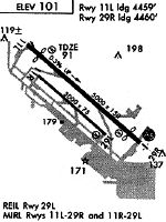
Runways
Runway Summary
| Runways: | 11L/29R 11R/29L H1 |
| Longest Runway: | 11L/29R is 5001 ft (1524 m) long |
| Runways with an Instrument Approach: | 29R |
TOA Airport Runway Details
| Runway 11L/29R | 5001 ft x 150 ft (1524 m x 46 m) | |
| Runway Length Source: | NGS as of 01/27/2009 | |
| Surface: | Asphalt/Concrete - Fair condition - No special surface treatment | |
| Runway Edge Lights: | Medium Intensity | |
Runway Weight Bearing Capacity (in thousands of pounds) |
||
| Single Wheel Landing Gear: | 30.0 | |
| Dual Wheel Landing Gear: | 50.0 | |
| Dual Tandem Wheel Landing Gear: | 90.0 | |
Runway 11L |
Runway 29R |
|
Elevation: |
83.0 | 96.8 |
Latitude: |
33-48-29.0133N | 33-47-58.2439N |
Longitude: |
118-20-44.4066W | 118-19-57.9996W |
|
Runway True Alignment: |
128 | 308 |
ILS Type: |
ILS/DME | |
Glide Path Angle: |
3.5 degrees | 4.0 degrees |
Traffic Pattern: |
Left | Right |
Runway Markings Type: |
Precision Instrument | Precision Instrument |
Runway Markings Condition: |
Fair | Fair |
Object at End: |
TREES | BLDG |
Object Height: |
35 | 22 |
Distance from End: |
690 | 475 |
Object Centerline Offset: |
0 ft. left and right of centerline | 530 ft. left of centerline |
Visual Glide Slope Indicators: |
2-Box VASI On Left Side Of Runway | 4-Box VASI On Left Side Of Runway |
Approach Light System: |
1,400 Foot Medium Intensity Approach Lighting System With Runway Alignment Indicator Lights | |
REIL: |
No | No |
Touchdown Lights: |
No | No |
Centerline Lights: |
No | No |
Threshold Crossing Height: |
10 | 11 |
Threshold Elevation: |
85.1 | 97.0 |
Displaced Threshold: |
541 | 540 |
Threshold Latitude: |
33-48-25.6871N | 33-48-01.5678N |
Threshold Longitude: |
118-20-39.3891W | 118-20-03.0119W |
| Runway 11R/29L | 3000 ft x 75 ft (914 m x 23 m) | |
| Runway Length Source: | NGS as of 01/27/2009 | |
| Surface: | Asphalt/Concrete - Fair condition - No special surface treatment | |
| Runway Edge Lights: | Medium Intensity | |
Runway Weight Bearing Capacity (in thousands of pounds) |
||
| Single Wheel Landing Gear: | 28.0 | |
Runway 11R |
Runway 29L |
|
Elevation: |
96.3 | 103.2 |
Latitude: |
33-48-18.9881N | 33-48-00.5334N |
Longitude: |
118-20-38.8141W | 118-20-10.9763W |
|
Runway True Alignment: |
128 | 308 |
Glide Path Angle: |
0.0 degrees | 4.0 degrees |
Traffic Pattern: |
Right | Left |
Runway Markings Type: |
Basic | Basic |
Runway Markings Condition: |
Fair | Fair |
Object at End: |
BLDG | |
Object Height: |
26 | |
Object Marked/Lighted?: |
Lighted | |
Distance from End: |
1400 | |
Object Centerline Offset: |
0 ft. left and right of centerline | 530 ft. left of centerline |
Visual Glide Slope Indicators: |
2-Box VASI On Left Side Of Runway | |
REIL: |
Yes | |
Touchdown Lights: |
No | No |
Centerline Lights: |
No | No |
Threshold Crossing Height: |
29 |
| Helipad H1 | 110 ft x 110 ft (34 m x 34 m) | |
| Runway Length Source: | NGS as of 01/27/2009 | |
| Surface: | Asphalt/Concrete - Fair condition - No special surface treatment | |
| Runway Edge Lights: | Perimeter lights (for helipads) Intensity | |
Helipad H1 |
||
Elevation: |
79.0 | |
Latitude: |
33-48-33.3800N | |
Longitude: |
118-20-44.3800W | |
Glide Path Angle: |
0.0 degrees | 0.0 degrees |
Object Centerline Offset: |
0 ft. left and right of centerline | 530 ft. left of centerline |
Services
Airframe Repair: |
Major |
Powerplant Repair: |
Major |
Bottled Oxygen: |
None |
Bulk Oxygen: |
None |
Fuel Available: |
100LL |
Landing Fees: |
No |
Parking: |
Tiedowns available |
Maps & Diagrams
TOA Sectional
Flight Planning
at skyvector.com
at skyvector.com