Location
Latitude: |
35-22-48.4510N (35.380125) |
Longitude: |
086-14-48.4020W (-86.246778) |
Elevation: |
1084.0 feet MSL (330 m MSL) |
Magnetic Variation: |
4.4 W (as of April 2024 from WMM2020 model) |
Time Zone: |
UTC -6.0 (Standard Time) UTC -5.0 (Daylight Savings Time) |
From City: |
02 N.M. NW of Tullahoma, Tennessee |
Found On: |
Atlanta Chart |
FAA Region: |
ASO |
Contacts
Manager: |
Publicly owned: |
| JON GLASS P.O. BOX 1584 TULLAHOMA, TN 37388 931-455-3884 |
CITY OF TULLAHOMA BOX 1584 TULLAHOMA, TN 37388 |
Operations
Airport Status: |
Operational |
Facility Use: |
Public |
Type: |
Airport |
Activation Date: |
10/1942 |
Control tower: |
No |
Attendance (Months/Days/Hours): |
Months/Days/Hours ALL/ALL/0800-1800 |
Boundary ARTCC: |
ZME (Memphis) |
Responsible ARTCC: |
ZME (Memphis) |
Lighting Schedule: |
SEE RMK |
Segmented Circle Indicator: |
Yes |
Traffic Pattern Altitude (MSL): |
2084 feet (635 m) |
NOTAMs Facility: |
BNA |
NOTAM-D Service: |
Yes |
International Airport of Entry: |
No |
Customs Landing Rights: |
No |
Military Landing Rights: |
Yes |
Civil/Military Joint Use: |
No |
Based Aircraft
| Single Engine: | 88 |
| Multi Engine: | 23 |
| Jet Engine: | 3 |
| GA Helicopters: | 5 |
| Gliders: | 2 |
Annual Operations (as of 12/31/2019)
| Total Operations: | 26500 | |
| Air Taxi: | 900 | 3.4% |
| GA Local: | 20400 | 77.0% |
| GA Itinerant: | 4000 | 15.1% |
| Military Aircraft: | 1200 | 4.5% |
Communications
| CTAF: | 123.000 |
| Unicom: | 123.000 |
| AWOS-3: | 128.325 (931-454-2052) |
- APCH/DEP SVC PRVDD BY MEMPHIS ARTCC ON FREQS 128.15/323.125 (SHELBYVILLE RCAG).
Fixed Based Operators (FBOs) & Fuel
(Click on a business for detail)
Please help us keep this information up to date. This is a FREE SERVICE just like everything else on Airport Guide! If you see that a business needs to be added, modified, or deleted please fill out our Update Form.
To add, modify, or delete a business click here.
Please help us keep this information up to date. This is a FREE SERVICE just like everything else on Airport Guide! If you see that a business needs to be added, modified, or deleted please fill out our Update Form.
Area Code: 931 |
| Business Name | Frequency | Phone | Fuel Grade |
|---|
Flight Service Stations
| Primary | Alternate | |
| FSS on Field: | N | |
| FSS Name (ID): | Nashville(BNA) | |
| Frequency: | ||
| Toll Free Phone: | 1-800-WX-BRIEF |
Instrument Procedures / Charts
FAA Terminal Procedures valid from 0901Z 03/21/24 to 0901Z 04/18/24.
There are various types of charts available for an airport. They are listed in the Page Type column. Here is a legend for those types:
APD - Airport Diagram
DP - Departure Procedure Charts
HOT - Hot Spots
IAP - Instrument Approach Procedure Charts
MIN - Minimums
STAR - Standard Terminal Arrival Charts
| Page Type | Page Name | Volume | Action Since Last Cycle |
|---|---|---|---|
| IAP | RNAV (GPS) RWY 06 | SE-1 | |
| IAP | RNAV (GPS) RWY 18 | SE-1 | |
| IAP | RNAV (GPS) RWY 24 | SE-1 | |
| IAP | RNAV (GPS) RWY 36 | SE-1 | |
| MIN | ALTERNATE MINIMUMS | SE-1 | |
| MIN | TAKEOFF MINIMUMS | SE-1 |
Terminal Procedures are only available for airports in several countries with more being added all the time. If you are looking for a specific country's charts, please send an email to support(at)airportguide.com stating the country name. This will be used to prioritize the implementation.
Navigation Aids (Navaids) near THA
| Dist (NM) | ID | Morse Code | Name | Type | Freq | True Hdg | Mag Hdg |
|---|---|---|---|---|---|---|---|
| 0.1 | UXM | . . _ _ . . _ _ _ | Tullahoma Regional | VOR | 109.65 | 70 | 74 |
| 4.9 | ULH | . . _ . _ . . . . . . | Burwi | NDB | 332 | 2 | 6 |
| 12.4 | SYI | . . . _ . _ _ . . | Bomar | FAN MARKER | 300 | 304 | |
| 14.4 | SYI | . . . _ . _ _ . . | Shelbyville | VOR-DME | 113.55 | 319 | 323 |
| 15.0 | BGF | _ . . . _ _ . . . _ . | Boiling Fork | NDB | 263 | 144 | 148 |
| 20.7 | TNY | _ _ . _ . _ _ | Kelso | NDB | 358 | 224 | 228 |
| 28.4 | LUG | . _ . . . . _ _ _ . | Verona | NDB | 251 | 284 | 288 |
| 32.5 | RN | . _ . _ . | Warri | NDB | 209 | 46 | 51 |
| 35.4 | FQW | . . _ . _ _ . _ . _ _ | Walter Hill | NDB | 371 | 350 | 354 |
| 36.2 | SWZ | . . . . _ _ _ _ . . | Sewart | NDB | 391 | 343 | 347 |
| 37.8 | APT | . _ . _ _ . _ | Jasper | NDB | 382 | 120 | 125 |
| 39.7 | MQY | _ _ _ _ . _ _ . _ _ | Smyrna | VOT | 110.20 | 341 | 345 |
| 39.8 | RQZ | . _ . _ _ . _ _ _ . . | Rocket | VORTAC | 112.20 | 208 | 212 |
| 42.1 | SKN | . . . _ . _ _ . | Hurricane | NDB | 256 | 30 | 35 |
| 43.5 | PBC | . _ _ . _ . . . _ . _ . | Maury County | NDB | 365 | 288 | 292 |
| 44.8 | CWH | _ . _ . . _ _ . . . . | Capshaw | NDB | 350 | 215 | 219 |
| 46.3 | HUA | . . . . . . _ . _ | Redstone | NDB | 287 | 208 | 212 |
| 48.5 | BNA | _ . . . _ . . _ | Nashville Metropoln | VOT | 108.60 | 335 | 339 |
| 48.6 | HEM | . . . . . _ _ | Huchn | NDB | 233 | 41 | 46 |
| 48.8 | JUE | . _ _ _ . . _ . | Lebanon | NDB | 414 | 356 | 360 |
Nearby Airports with Fuel
Notices to Airmen (NOTAMS)
Remarks
| A110-1 | PAJA, GLIDER OPS, GEESE & DEER ON & INVOF ARPT; PAJA LNDG ZONE E OF PAVED RWY 18/36 MIDFIELD. |
| A110-4 | FOR CD CTC MEMPHIS ARTCC AT 901-368-8453/8449. |
| A30-09/27 | FICON SOFT SFC WHEN WET. |
| A30A-24 | 26:1 TO DTHR. |
| A30A-36 | 26:1 TO DTHR. |
| A42-18 | FADED & PEELING. |
| A42-36 | FADED & PEELING. |
| A43-36 | UNUSBL BYD 7 DEGS LEFT AND RIGHT OF CNTRLN. |
| A81-APT | ACTVT ODALS RWY 06; PAPI RWY 18 & 36; MIRL RWY 18/36 - CTAF. MIRL RWY 06/24 PRESET TO LOW INTST; INCR INTST - CTAF. |
| E111 | EXISTED PRIOR TO 1959 |
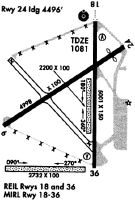
Runways
Runway Summary
| Runways: | 06/24 09/27 18/36 N/S |
| Longest Runway: | 06/24 is 5501 ft (1677 m) long |
| Runways with an Instrument Approach: | 18 |
THA Airport Runway Details
| Runway 06/24 | 5501 ft x 100 ft (1677 m x 30 m) | |
| Runway Length Source: | 3RD PARTY SURVEY as of 11/26/2020 | |
| Surface: | Asphalt/Concrete - Good condition - No special surface treatment | |
| Runway Pavement Class: | 29 /F/C/X/T | |
| Runway Edge Lights: | Medium Intensity | |
Runway Weight Bearing Capacity (in thousands of pounds) |
||
| Single Wheel Landing Gear: | 49.0 | |
| Dual Wheel Landing Gear: | 60.0 | |
Runway 06 |
Runway 24 |
|
Elevation: |
1083.9 | 1077.7 |
Latitude: |
35-22-39.8360N | 35-23-08.8351N |
Longitude: |
086-15-20.6619W | 086-14-24.4573W |
|
Runway True Alignment: |
058 | 238 |
Glide Path Angle: |
3.0 degrees | 3.0 degrees |
Runway Markings Type: |
Nonprecision Instrument | Nonprecision Instrument |
Runway Markings Condition: |
Good | Good |
Object at End: |
TREE | TREE |
Object Height: |
42 | 69 |
Distance from End: |
1097 | 1280 |
Object Centerline Offset: |
138 ft. left of centerline | 211 ft. left of centerline |
Visual Glide Slope Indicators: |
2-Light PAPI On Left Side Of Runway | 2-Light PAPI On Left Side Of Runway |
Approach Light System: |
Omnidirectional Approach Lighting System | |
REIL: |
Yes | Yes |
Threshold Crossing Height: |
41 | 33 |
Threshold Elevation: |
1080.5 | |
Displaced Threshold: |
500 | |
Threshold Latitude: |
35-23-06.1997N | |
Threshold Longitude: |
086-14-29.5651W |
| Runway 09/27 | 3130 ft x 100 ft (954 m x 30 m) | |
| Runway Length Source: | 3RD PARTY SURVEY as of 11/26/2020 | |
| Surface: | Asphalt/Concrete - Good condition - No special surface treatment | |
Runway 09 |
Runway 27 |
|
Elevation: |
1077.0 | 1075.1 |
Latitude: |
35-22-27.1562N | 35-22-27.4663N |
Longitude: |
086-15-20.7544W | 086-14-42.9607W |
|
Runway True Alignment: |
089 | 269 |
Glide Path Angle: |
0.0 degrees | 0.0 degrees |
Traffic Pattern: |
Right | |
Runway Markings Type: |
Basic | Basic |
Runway Markings Condition: |
Good | Good |
Object at End: |
TREE | TREE |
Object Height: |
45 | 62 |
Distance from End: |
1041 | 1305 |
Object Centerline Offset: |
138 ft. left of centerline | 211 ft. left of centerline |
| Runway 18/36 | 4205 ft x 100 ft (1282 m x 30 m) | |
| Runway Length Source: | 3RD PARTY SURVEY as of 11/26/2020 | |
| Surface: | Asphalt/Concrete - Good condition - No special surface treatment | |
| Runway Edge Lights: | Medium Intensity | |
Runway Weight Bearing Capacity (in thousands of pounds) |
||
| Single Wheel Landing Gear: | 37.0 | |
Runway 18 |
Runway 36 |
|
Elevation: |
1078.8 | 1081.7 |
Latitude: |
35-23-17.1218N | 35-22-35.5376N |
Longitude: |
086-14-36.8412W | 086-14-36.7065W |
|
Runway True Alignment: |
180 | 000 |
ILS Type: |
SDF | |
Glide Path Angle: |
3.0 degrees | 3.0 degrees |
Traffic Pattern: |
Left | Left |
Runway Markings Type: |
Nonprecision Instrument | Nonprecision Instrument |
Runway Markings Condition: |
Poor | Poor |
Object at End: |
TREE | TREE |
Object Height: |
21 | 70 |
Distance from End: |
769 | 1054 |
Object Centerline Offset: |
138 ft. left of centerline | 211 ft. left of centerline |
Visual Glide Slope Indicators: |
2-Light PAPI On Left Side Of Runway | 2-Light PAPI On Left Side Of Runway |
REIL: |
Yes | Yes |
Threshold Crossing Height: |
34 | 42 |
| Runway N/S | 2083 ft x 100 ft (635 m x 30 m) | |
| Runway Length Source: | 3RD PARTY SURVEY as of 11/05/2013 | |
| Surface: | Asphalt/Concrete - Good condition - No special surface treatment | |
Runway N |
Runway S |
|
Elevation: |
1079.6 | 1079.8 |
Latitude: |
35-22-38.4694N | 35-22-59.0660N |
Longitude: |
086-14-40.6282W | 086-14-40.7072W |
|
Runway True Alignment: |
360 | 180 |
Glide Path Angle: |
0.0 degrees | 0.0 degrees |
Object at End: |
TREE | TREE |
Object Height: |
102 | 68 |
Distance from End: |
2489 | 2159 |
Object Centerline Offset: |
138 ft. left of centerline | 211 ft. left of centerline |
Services
Airframe Repair: |
Major |
Powerplant Repair: |
Major |
Fuel Available: |
100LL, Jet A |
Landing Fees: |
No |
Parking: |
Hangars and tiedowns available |
Maps & Diagrams
THA Sectional
Flight Planning
at skyvector.com
at skyvector.com