Location
Latitude: |
66-01-01.8000N (66.017167) |
Longitude: |
149-03-15.7000W (-149.054361) |
Elevation: |
328.3 feet MSL (100 m MSL) |
Magnetic Variation: |
15.2 E (as of April 2024 from WMM2020 model) |
Time Zone: |
UTC -9.0 (Standard Time) UTC -8.0 (Daylight Savings Time) |
From City: |
01 N.M. NNE of Stevens Village, Alaska |
Found On: |
Fairbanks Chart |
FAA Region: |
AAL |
Contacts
Manager: |
Publicly owned: |
| JASON LUDINGTON 2301 PEGER RD FAIRBANKS, AK 99709 (907) 451-5280 |
ALASKA DOT&PF NORTHERN REGION 2301 PEGER RD FAIRBANKS, AK 99709 (907) 451-5280 |
Operations
Airport Status: |
Operational |
Facility Use: |
Public |
Type: |
Airport |
Activation Date: |
07/1953 |
Control tower: |
No |
Attendance (Months/Days/Hours): |
Months/Days/Hours Unattended |
Boundary ARTCC: |
ZAN (Anchorage) |
Responsible ARTCC: |
ZAN (Anchorage) |
Lighting Schedule: |
SEE RMK |
Segmented Circle Indicator: |
Yes |
Traffic Pattern Altitude (MSL): |
1328 feet (405 m) |
NOTAMs Facility: |
FAI |
NOTAM-D Service: |
Yes |
International Airport of Entry: |
No |
Customs Landing Rights: |
No |
Military Landing Rights: |
No |
Civil/Military Joint Use: |
No |
Based Aircraft
Annual Operations (as of 12/31/2019)
| Total Operations: | 750 | |
| Air Taxi: | 250 | 33.3% |
| GA Itinerant: | 500 | 66.7% |
Communications
| CTAF: | 122.900 |
Fixed Based Operators (FBOs) & Fuel
(Click on a business for detail)
Please help us keep this information up to date. This is a FREE SERVICE just like everything else on Airport Guide! If you see that a business needs to be added, modified, or deleted please fill out our Update Form.
To add, modify, or delete a business click here.
Please help us keep this information up to date. This is a FREE SERVICE just like everything else on Airport Guide! If you see that a business needs to be added, modified, or deleted please fill out our Update Form.
Area Code: 907 |
| Business Name | Frequency | Phone | Fuel Grade |
|---|
Flight Service Stations
| Primary | Alternate | |
| FSS on Field: | N | |
| FSS Name (ID): | Fairbanks(FAI) | |
| Frequency: | ||
| Toll Free Phone: | 1-866-248-6516 |
Instrument Procedures / Charts
Terminal Procedures are only available for airports in several countries with more being added all the time. If you are looking for a specific country's charts, please send an email to support(at)airportguide.com stating the country name. This will be used to prioritize the implementation.
Navigation Aids (Navaids) near SVS
| Dist (NM) | ID | Morse Code | Name | Type | Freq | True Hdg | Mag Hdg |
|---|---|---|---|---|---|---|---|
| 61.2 | PPC | . _ _ . . _ _ . _ . _ . | Prospect | NDB | 340 | 322 | 307 |
| 72.8 | FOX | . . _ . _ _ _ _ . . _ | Fox | NDB | 356 | 149 | 134 |
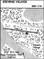
| 77.5 | FAI | . . _ . . _ . . | Fairbanks | VORTAC | 108.60 | 159 | 144 |
| 79.8 | BTT | _ . . . _ _ | Bettles | VOR-DME | 116.00 | 312 | 297 |
| 79.9 | EAV | . . _ . . . _ | Evansville | NDB | 391 | 312 | 297 |
| 80.7 | CUN | _ . _ . . . _ _ . | Chena | NDB | 257 | 150 | 135 |
| 85.6 | ENN | . _ . _ . | Nenana | VORTAC | 115.80 | 180 | 165 |
| 88.3 | ICW | . . _ . _ . . _ _ | Ice Pool | NDB | 525 | 180 | 165 |
| 90.2 | CQR | _ . _ . _ _ . _ . _ . | Chandalar Lake | NDB | 263 | 8 | 353 |
| 92.4 | TAL | _ . _ . _ . . | Tanana | VOR-DME | 116.60 | 238 | 223 |
| 93.1 | BCC | _ . . . _ . _ . _ . _ . | Bear Creek | NDB | 212 | 238 | 223 |
| 95.4 | EIL | . . . . _ . . | Eielson | TACAN | 115.10 | 148 | 132 |
| 97.0 | FYU | . . _ . _ . _ _ . . _ | Fort Yukon | VORTAC | 114.40 | 68 | 52 |
| 98.6 | FTO | . . _ . _ _ _ _ | Yukon River | NDB | 242 | 68 | 52 |
Nearby Airports with Fuel
| Dist (NM) | Name (Airport IDs) | True Hdg | Mag Hdg | Fuel Grade |
|---|---|---|---|---|
| 78.1 | Fairbanks International Airport (FAI PAFA FAI) |
156 | 140 | 100LL, Jet A-1 |
| 80.1 | Bettles Airport (BTT PABT BTT) |
313 | 299 | 100LL, Jet A-1+ |
| 86.2 | Bradley Sky-Ranch Airport (95Z) |
150 | 134 | 100LL |
| 88.2 | Nenana Municipal Airport (ENN PANN ENN) |
180 | 165 | 100LL, Jet A |
Notices to Airmen (NOTAMS)
Remarks
| A110-2 | RWY 05/23 COND NOT MONITORED; RCMD VISUAL INSPECTION PRIOR TO LNDG. |
| A110-4 | SNOW REMOVAL OPERATIONS DURING WINTER--MONITOR CTAF. |
| A110-5 | CLSD RWY LOCATED 1 NM WEST OF RWY 05/23. |
| A42-05 | RY 05/23 MARKED WITH LIGHTS AND CONES. |
| A81-APT | ACTVT REIL RWY 05 & 23; PAPI RWY 05 & 23; MIRL RWY 05/23 - CTAF. |
| A81-BCN | ACTVT ROTG BEACON - CTAF. |
Runways
Runway Summary
| Runways: | 05/23 |
| Longest Runway: | 05/23 is 4000 ft (1219 m) long |
| Runways with an Instrument Approach: |
SVS Airport Runway Details
| Runway 05/23 | 4000 ft x 75 ft (1219 m x 23 m) | |
| Runway Length Source: | 3RD PARTY SURVEY as of 08/05/2008 | |
| Surface: | Gravel/Dirt - Good condition - No special surface treatment | |
| Runway Edge Lights: | Medium Intensity | |
Runway 05 |
Runway 23 |
|
Elevation: |
322.1 | 325.5 |
Latitude: |
66-00-55.3660N | 66-01-08.2537N |
Longitude: |
149-04-01.4115W | 149-02-30.0242W |
Glide Path Angle: |
3.0 degrees | 3.0 degrees |
Traffic Pattern: |
Left | Left |
Runway Markings Type: |
Nonstandard (other than numbers only) | Nonstandard (other than numbers only) |
Runway Markings Condition: |
Good | Good |
Object at End: |
TREES | TREES |
Object Height: |
15 | 30 |
Distance from End: |
35 | 100 |
Object Centerline Offset: |
120 ft. left of centerline | 25 ft. right of centerline |
Visual Glide Slope Indicators: |
4-Light PAPI On Left Side Of Runway | 4-Light PAPI On Left Side Of Runway |
REIL: |
Yes | Yes |
Threshold Crossing Height: |
25 | 25 |
Services
Airframe Repair: |
None |
Powerplant Repair: |
None |
Bottled Oxygen: |
None |
Bulk Oxygen: |
None |
Fuel Available: |
100LL, Jet A |
Landing Fees: |
No |
Parking: |
Tiedowns available |
Maps & Diagrams
SVS Sectional
Flight Planning
at skyvector.com
at skyvector.com