Location
Latitude: |
43-03-51.3000N (43.06425) |
Longitude: |
108-27-35.4000W (-108.459833) |
Elevation: |
5515.9 feet MSL (1681 m MSL) |
Magnetic Variation: |
9.8 E (as of April 2024 from WMM2020 model) |
Time Zone: |
UTC -7.0 (Standard Time) UTC -6.0 (Daylight Savings Time) |
From City: |
03 N.M. NW of Riverton, Wyoming |
Found On: |
Cheyenne Chart |
FAA Region: |
ANM |
Contacts
Manager: |
Publicly owned: |
| KYLE BUTTERFIELD 816 NORTH FEDERAL BLVD RIVERTON, WY 82501 (307) 857-7704 |
CITY OF RIVERTON 816 N FEDERAL BLVD. RIVERTON, WY 82501 (307) 857-7780 |
Operations
Airport Status: |
Operational |
Facility Use: |
Public |
Type: |
Airport |
Activation Date: |
11/1937 |
Control tower: |
No |
Attendance (Months/Days/Hours): |
Months/Days/Hours ALL/MON-FRI/0700-1700 |
Boundary ARTCC: |
ZLC (Salt Lake City) |
Responsible ARTCC: |
ZLC (Salt Lake City) |
Lighting Schedule: |
SEE RMK |
Segmented Circle Indicator: |
Yes |
Traffic Pattern Altitude (MSL): |
6516 feet (1986 m) |
NOTAMs Facility: |
RIW |
NOTAM-D Service: |
Yes |
International Airport of Entry: |
No |
Customs Landing Rights: |
No |
Military Landing Rights: |
Yes |
Civil/Military Joint Use: |
No |
Aircraft Rescue and Firefighting: |
Class I ARFF Index: A Air Carrier Service: Scheduled Certification Date: 05/1973 |
Based Aircraft
| Single Engine: | 28 |
| Multi Engine: | 3 |
Annual Operations (as of 01/01/2019)
| Total Operations: | 4547 | |
| Air Taxi: | 1003 | 22.1% |
| GA Local: | 1561 | 34.3% |
| GA Itinerant: | 1974 | 43.4% |
| Military Aircraft: | 9 | 0.2% |
Communications
| CTAF: | 122.800 |
| Unicom: | 122.800 |
| ASOS: | 121.425 (307-856-4473) |
- APCH/DEP CTL SVC PRVDD BY SALT LAKE ARTCC (ZLC) ON FREQS 133.25/285.6 (BOYSEN RCAG).
Fixed Based Operators (FBOs) & Fuel
(Click on a business for detail)
Please help us keep this information up to date. This is a FREE SERVICE just like everything else on Airport Guide! If you see that a business needs to be added, modified, or deleted please fill out our Update Form.
To add, modify, or delete a business click here.
Please help us keep this information up to date. This is a FREE SERVICE just like everything else on Airport Guide! If you see that a business needs to be added, modified, or deleted please fill out our Update Form.
Area Code: 307 |
| Business Name | Frequency | Phone | Fuel Grade |
|---|---|---|---|
| Western Exec Air
Update FBO info |
Unicom 122.8 | 856-6671 | 100ll, Jet A |
Flight Service Stations
| Primary | Alternate | |
| FSS on Field: | N | |
| FSS Name (ID): | Casper(CPR) | |
| Frequency: | ||
| Toll Free Phone: | 1-800-WX-BRIEF |
Instrument Procedures / Charts
FAA Terminal Procedures valid from 0901Z 03/21/24 to 0901Z 04/18/24.
There are various types of charts available for an airport. They are listed in the Page Type column. Here is a legend for those types:
APD - Airport Diagram
DP - Departure Procedure Charts
HOT - Hot Spots
IAP - Instrument Approach Procedure Charts
MIN - Minimums
STAR - Standard Terminal Arrival Charts
| Page Type | Page Name | Volume | Action Since Last Cycle |
|---|---|---|---|
| APD | AIRPORT DIAGRAM | NW-1 | |
| IAP | ILS OR LOC RWY 28 | NW-1 | |
| IAP | RNAV (GPS) RWY 10 | NW-1 | |
| IAP | RNAV (GPS) RWY 28 | NW-1 | |
| IAP | VOR RWY 10 | NW-1 | |
| IAP | VOR RWY 28 | NW-1 | |
| MIN | ALTERNATE MINIMUMS | NW-1 | |
| MIN | TAKEOFF MINIMUMS | NW-1 |
Terminal Procedures are only available for airports in several countries with more being added all the time. If you are looking for a specific country's charts, please send an email to support(at)airportguide.com stating the country name. This will be used to prioritize the implementation.
Navigation Aids (Navaids) near RIW
| Dist (NM) | ID | Morse Code | Name | Type | Freq | True Hdg | Mag Hdg |
|---|---|---|---|---|---|---|---|
| 0.2 | RIW | . _ . . . . _ _ | Riverton | VOR-DME | 114.05 | 65 | 55 |
| 24.9 | BOY | _ . . . _ _ _ _ . _ _ | Boysen Reservoir | VOR-DME | 117.80 | 16 | 6 |
| 58.4 | RLY | . _ . . _ . . _ . _ _ | Worland | VOR-DME | 114.80 | 22 | 12 |
| 61.3 | PNA | . _ _ . _ . . _ | Wenz | NDB | 392 | 255 | 245 |
| 78.2 | BPI | _ . . . . _ _ . . . | Big Piney | VOR-DME | 116.50 | 248 | 238 |
| 83.5 | CP | _ . _ . . _ _ . | Johno | NDB | 375 | 95 | 86 |
| 87.6 | CKW | _ . _ . _ . _ . _ _ | Cherokee | VOR-DME | 115.00 | 153 | 144 |
| 88.4 | GEY | _ _ . . _ . _ _ | Greybull | NDB | 275 | 10 | 0 |
| 91.8 | OCS | _ _ _ _ . _ . . . . | Rock Springs | VOR-DME | 116.00 | 195 | 185 |
| 93.7 | DNW | _ . . _ . . _ _ | Dunoir | VOR-DME | 117.20 | 299 | 289 |
| 93.8 | RWL | . _ . . _ _ . _ . . | Rawlins | VOR-DME | 109.40 | 143 | 134 |
| 95.7 | DDY | _ . . _ . . _ . _ _ | Muddy Mountain | VOR-DME | 116.20 | 88 | 79 |
| 95.9 | COD | _ . _ . _ _ _ _ . . | Cody | VOR-DME | 111.80 | 347 | 337 |
Nearby Airports with Fuel
| Dist (NM) | Name (Airport IDs) | True Hdg | Mag Hdg | Fuel Grade |
|---|---|---|---|---|
| 0.0 | Central Wyoming Regional Airport (RIW KRIW RIW) |
0 | 350 | 100LL, Jet A |
| 19.0 | Hunt Field Airport (LND KLND LND) |
218 | 208 | 100LL, Jet A |
| 58.3 | Worland Municipal Airport (WRL KWRL WRL) |
22 | 12 | 100LL, Jet A |
| 61.1 | Dubois Municipal Airport (KDUB DUB) |
298 | 288 | 100LL, Jet A |
| 61.5 | Ralph Wenz Field Airport (KPNA PNA) |
255 | 245 | 100LL, Jet A |
| 78.1 | Miley Meml Field Airport (BPI KBPI BPI) |
248 | 238 | 100LL, Jet A |
| 88.1 | Casper/Natrona County International Airport (CPR KCPR CPR) |
95 | 86 | 100LL, Jet A |
| 88.7 | South Big Horn County Airport (GEY KGEY GEY) |
10 | 0 | 100LL, Jet A |
| 90.7 | Yellowstone Regional Airport (COD KCOD COD) |
344 | 334 | 100, 100LL, Jet A, Jet A+ |
| 92.2 | Southwest Wyoming Regional Airport (RKS KRKS RKS) |
197 | 187 | 100LL, Jet A-1+ |
| 93.9 | Rawlins Municipal/Harvey Field Airport (RWL KRWL RWL) |
143 | 134 | 100LL, Jet A |
Notices to Airmen (NOTAMS)
Remarks
| A110-4 | GA ACFT NOT AUZD ON WEST RAMP. |
| A110-5 | MULTIPLE HOT AIR BALLOONS INVOF ARPT DURING JULY. |
| A110-6 | CONDS NOT MONITORED AT NGT AFT THE LAST ACR ARR TIL 0500L. SEE NOTAMS FOR THE MOST UP-TO-DATE CONDS AND UPDTS. |
| A110-7 | FOR CD IF UNA TO CTC ON FSS FREQ, CTC SALT LAKE ARTCC AT 801-320-2568. |
| A17 | FOR SVC AFTER HRS CALL 307-856-3599. |
| A26 | PPR FOR UNSKED OPNS WITH MORE THAN 30 PSGR SEATS CALL AMGR 307-857-7780/307-856-7063. |
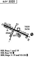
| A81-APT | ACTVT HIRL RY 10/28; MIRL RY 01/19; REIL RY 01 & RY 19; AND REIL RY 10; MALSR RY 28 - CTAF. PAPI RY 01, RY 19, RY 10 & RY 28 OPER 24 HRS. |
Runways
Runway Summary
| Runways: | 01/19 10/28 |
| Longest Runway: | 10/28 is 8204 ft (2501 m) long |
| Runways with an Instrument Approach: | 28 |
RIW Airport Runway Details
| Runway 01/19 | 4800 ft x 75 ft (1463 m x 23 m) | |
| Runway Length Source: | 3RD PARTY SURVEY as of 03/23/2016 | |
| Surface: | Asphalt - Good condition - Saw-cut or plastic grooved | |
| Runway Edge Lights: | Medium Intensity | |
Runway Weight Bearing Capacity (in thousands of pounds) |
||
| Single Wheel Landing Gear: | 30.0 | |
| Dual Wheel Landing Gear: | 50.0 | |
Runway 01 |
Runway 19 |
|
Elevation: |
5462.7 | 5479.7 |
Latitude: |
43-03-25.4206N | 43-04-08.6172N |
Longitude: |
108-27-56.5887W | 108-27-29.9704W |
|
Runway True Alignment: |
024 | 204 |
Glide Path Angle: |
3.0 degrees | 3.0 degrees |
Runway Markings Type: |
Nonprecision Instrument | Nonprecision Instrument |
Runway Markings Condition: |
Good | Good |
Object at End: |
PLINE | |
Visual Glide Slope Indicators: |
2-Light PAPI On Left Side Of Runway | 2-Light PAPI On Left Side Of Runway |
REIL: |
Yes | Yes |
Threshold Crossing Height: |
43 | 42 |
Declared Distances |
||
Take Off Run Avbl. (TORA): |
4800 | 4800 |
Take Off Distance Avbl. (TODA): |
4800 | 4800 |
Actual Stop Dist. Avbl. (ASDA): |
4800 | 4800 |
Landing Dist. Avbl. (LDA): |
4800 | 4800 |
| Runway 10/28 | 8204 ft x 150 ft (2501 m x 46 m) | |
| Runway Length Source: | 3RD PARTY SURVEY as of 03/23/2016 | |
| Surface: | Asphalt - Good condition - Saw-cut or plastic grooved | |
| Runway Edge Lights: | High Intensity | |
Runway Weight Bearing Capacity (in thousands of pounds) |
||
| Single Wheel Landing Gear: | 85.0 | |
| Dual Wheel Landing Gear: | 110.0 | |
| Dual Tandem Wheel Landing Gear: | 165.0 | |
Runway 10 |
Runway 28 |
|
Elevation: |
5515.9 | 5442.9 |
Latitude: |
43-04-10.4070N | 43-03-37.0613N |
Longitude: |
108-28-21.1751W | 108-26-40.4952W |
|
Runway True Alignment: |
114 | 294 |
ILS Type: |
ILS | |
Glide Path Angle: |
3.0 degrees | 3.0 degrees |
Traffic Pattern: |
Left | Left |
Runway Markings Type: |
Precision Instrument | Precision Instrument |
Runway Markings Condition: |
Good | Good |
Object at End: |
PLINE | |
Object Height: |
133 | |
Distance from End: |
3950 | |
Visual Glide Slope Indicators: |
4-Light PAPI On Left Side Of Runway | 4-Light PAPI On Right Side Of Runway |
Approach Light System: |
1,400 Foot Medium Intensity Approach Lighting System With Runway Alignment Indicator Lights | |
REIL: |
Yes | |
Threshold Crossing Height: |
49 | 50 |
Declared Distances |
||
Take Off Run Avbl. (TORA): |
8204 | 8204 |
Take Off Distance Avbl. (TODA): |
8204 | 8204 |
Actual Stop Dist. Avbl. (ASDA): |
8204 | 8204 |
Landing Dist. Avbl. (LDA): |
8204 | 8204 |
Services
Airframe Repair: |
None |
Powerplant Repair: |
None |
Bottled Oxygen: |
None |
Bulk Oxygen: |
None |
Fuel Available: |
100LL, Jet A |
Landing Fees: |
No |
Parking: |
Tiedowns available |
Maps & Diagrams
RIW Sectional
Flight Planning
at skyvector.com
at skyvector.com