Location
Latitude: |
41-21-54.4700N (41.365131) |
Longitude: |
086-18-00.9280W (-86.300258) |
Elevation: |
799.9 feet MSL (244 m MSL) |
Magnetic Variation: |
5.1 W (as of April 2024 from WMM2020 model) |
Time Zone: |
UTC -5.0 (Standard Time) UTC -4.0 (Daylight Savings Time) |
From City: |
02 N.M. N of Plymouth, Indiana |
Found On: |
Chicago Chart |
FAA Region: |
AGL |
Contacts
Manager: |
Publicly owned: |
| BILL SHELEY 301 AIRPORT DRIVE PLYMOUTH, IN 46563 (574) 320-5059 |
PLYMOUTH BOAC 301 AIRPORT DRIVE PLYMOUTH, IN 46563 574-935-5152 |
Operations
Airport Status: |
Operational |
Facility Use: |
Public |
Type: |
Airport |
Activation Date: |
12/1966 |
Control tower: |
No |
Attendance (Months/Days/Hours): |
Months/Days/Hours ALL/MON-FRI/0800-1700 |
Boundary ARTCC: |
ZAU (Chicago) |
Responsible ARTCC: |
ZAU (Chicago) |
Lighting Schedule: |
SEE RMK |
Segmented Circle Indicator: |
Yes |
Traffic Pattern Altitude (MSL): |
1800 feet (549 m) |
NOTAMs Facility: |
HUF |
NOTAM-D Service: |
Yes |
International Airport of Entry: |
No |
Customs Landing Rights: |
No |
Military Landing Rights: |
Yes |
Civil/Military Joint Use: |
No |
Based Aircraft
| Single Engine: | 19 |
| Multi Engine: | 2 |
| GA Helicopters: | 3 |
Annual Operations (as of 12/31/2019)
| Total Operations: | 10500 | |
| Air Taxi: | 2099 | 20.0% |
| GA Local: | 5671 | 54.0% |
| GA Itinerant: | 2730 | 26.0% |
Communications
| CTAF: | 122.975 |
| Unicom: | 122.975 |
| Approach: | SOUTH BEND 132.05 132.05 CHICAGO ARTCC |
| Departure: | SOUTH BEND 132.05 132.05 CHICAGO ARTCC |
| AWOS-3: | 133.025 (574-935-3854) |
- APCH/DEP SVC PRVDD BY CHICAGO ARTCC ON FREQS 135.9/314.0 (GOSHEN RCAG) WHEN SOUTH BEND APCH CTL CLSD.
Fixed Based Operators (FBOs) & Fuel
(Click on a business for detail)
Please help us keep this information up to date. This is a FREE SERVICE just like everything else on Airport Guide! If you see that a business needs to be added, modified, or deleted please fill out our Update Form.
To add, modify, or delete a business click here.
Please help us keep this information up to date. This is a FREE SERVICE just like everything else on Airport Guide! If you see that a business needs to be added, modified, or deleted please fill out our Update Form.
Area Code: 219 |
| Business Name | Frequency | Phone | Fuel Grade |
|---|---|---|---|
| Plymouth Aviation, Inc
Update FBO info |
Unicom 122.8 | 935-5152, 936-5172 | 80, 100LL, Jet A |
Flight Service Stations
| Primary | Alternate | |
| FSS on Field: | N | |
| FSS Name (ID): | Terre Haute(HUF) | |
| Frequency: | ||
| Toll Free Phone: | 1-800-WX-BRIEF |
Instrument Procedures / Charts
FAA Terminal Procedures valid from 0901Z 03/21/24 to 0901Z 04/18/24.
There are various types of charts available for an airport. They are listed in the Page Type column. Here is a legend for those types:
APD - Airport Diagram
DP - Departure Procedure Charts
HOT - Hot Spots
IAP - Instrument Approach Procedure Charts
MIN - Minimums
STAR - Standard Terminal Arrival Charts
| Page Type | Page Name | Volume | Action Since Last Cycle |
|---|---|---|---|
| IAP | RNAV (GPS) RWY 10 | EC-2 | |
| IAP | RNAV (GPS) RWY 28 | EC-2 | |
| MIN | ALTERNATE MINIMUMS | EC-2 | |
| MIN | TAKEOFF MINIMUMS | EC-2 |
Terminal Procedures are only available for airports in several countries with more being added all the time. If you are looking for a specific country's charts, please send an email to support(at)airportguide.com stating the country name. This will be used to prioritize the implementation.
Navigation Aids (Navaids) near PLY
| Dist (NM) | ID | Morse Code | Name | Type | Freq | True Hdg | Mag Hdg |
|---|---|---|---|---|---|---|---|
| 9.7 | CPB | _ . _ . . _ _ . _ . . . | Culver | NDB | 391 | 203 | 208 |
| 15.6 | GSH | _ _ . . . . . . . . | Goshen | VORTAC | 113.70 | 51 | 56 |
| 15.9 | OXI | _ _ _ _ . . _ . . | Knox | DME | 115.6 | 260 | 265 |
| 20.8 | SB | . . . _ . . . | Misha | NDB | 341 | 10 | 15 |
| 21.3 | RWN | . _ . . _ _ _ . | Winamac/Dcmsnd | NDB | 335 | 220 | 225 |
| 22.7 | IUL | . . . . _ . _ . . | La Porte | NDB | 356 | 290 | 295 |
| 24.2 | GIJ | _ _ . . . . _ _ _ | Gipper | VORTAC | 115.40 | 358 | 363 |
| 26.5 | VP | . . . _ . _ _ . | Sedly | NDB | 212 | 281 | 286 |
| 36.9 | OLK | _ _ _ . _ . . _ . _ | Webster Lake | VOR | 110.40 | 100 | 105 |
| 42.7 | IWH | . . . _ _ . . . . | Wabash | NDB | 329 | 147 | 152 |
| 43.7 | GUS | _ _ . . . _ . . . | Grissom | VORTAC | 108.45 | 171 | 176 |
| 45.7 | BE | _ . . . . | Mally | NDB | 397 | 359 | 364 |
| 47.3 | IRS | . . . _ . . . . | Sturgis | NDB | 382 | 55 | 60 |
| 47.4 | ELX | . . _ . . _ . . _ | Keeler | VOR-DME | 116.60 | 9 | 14 |
| 47.7 | HAI | . . . . . _ . . | Three Rivers | NDB | 407 | 41 | 46 |
| 48.6 | HHG | . . . . . . . . _ _ . | Huntington | NDB | 417 | 128 | 133 |
| 51.4 | OKK | _ _ _ _ . _ _ . _ | Kokomo | TACAN | 113.50 | 167 | 172 |
| 55.2 | FWA | . . _ . . _ _ . _ | Fort Wayne Baer | VOT | 111.00 | 114 | 119 |
| 55.3 | FWA | . . _ . . _ _ . _ | Fort Wayne | VORTAC | 117.80 | 114 | 119 |
| 57.0 | ANQ | . _ _ . _ _ . _ | Angola | NDB | 347 | 72 | 78 |
Nearby Airports with Fuel
Notices to Airmen (NOTAMS)
Remarks
| A11 | PHIL BOCKMAN |
| A110-1 | FLT TRNG & BIRDS ON & INVOF ARPT. |
| A110-3 | WINTER SNOW REMOVAL OPS; OPR MONITOR CTAF. |
| A110-4 | FOR CD CTC SOUTH BEND APCH AT 574-251-2609. WHEN SOUTH BEND APCH CLSD, FOR CD CTC CHICAGO ARTCC AT 630-906-8921. |
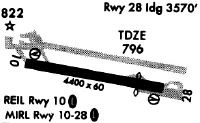
| A57-28 | APCH RATIO 34:1 AT DSPLCD THR. |
| A70-FUEL-10 | 0LL SELF SERVE AVBL H24. |
| A81-APT | ACTVT REIL RWY 10 & 28; PAPI RWY 10; VASI RWY 28; MIRL RWY 10/28 - CTAF. |
Runways
Runway Summary
| Runways: | 10/28 |
| Longest Runway: | 10/28 is 4400 ft (1341 m) long |
| Runways with an Instrument Approach: |
PLY Airport Runway Details
| Runway 10/28 | 4400 ft x 75 ft (1341 m x 23 m) | |
| Runway Length Source: | 3RD PARTY SURVEY as of 06/07/2018 | |
| Surface: | Asphalt - Good condition - No special surface treatment | |
| Runway Edge Lights: | Medium Intensity | |
Runway Weight Bearing Capacity (in thousands of pounds) |
||
| Single Wheel Landing Gear: | 25.0 | |
| Dual Wheel Landing Gear: | 40.0 | |
Runway 10 |
Runway 28 |
|
Elevation: |
795.9 | 799.9 |
Latitude: |
41-21-56.6500N | 41-21-52.2882N |
Longitude: |
086-18-29.6331W | 086-17-32.2228W |
|
Runway True Alignment: |
096 | 276 |
Glide Path Angle: |
3.0 degrees | 3.3 degrees |
Traffic Pattern: |
Left | Left |
Runway Markings Type: |
Nonprecision Instrument | Nonprecision Instrument |
Runway Markings Condition: |
Good | Good |
Object at End: |
TREE | ROAD |
Object Height: |
85 | 15 |
Distance from End: |
2000 | 490 |
Object Centerline Offset: |
183 ft. left and right of centerline | 300 ft. left and right of centerline |
Visual Glide Slope Indicators: |
2-Light PAPI On Left Side Of Runway | 4-Box VASI On Left Side Of Runway |
REIL: |
Yes | Yes |
Touchdown Lights: |
No | No |
Centerline Lights: |
No | No |
Threshold Crossing Height: |
28 | 28 |
Threshold Elevation: |
795.8 | |
Displaced Threshold: |
297 | |
Threshold Latitude: |
41-21-52.5827N | |
Threshold Longitude: |
086-17-36.0925W |
Services
Airframe Repair: |
Major |
Powerplant Repair: |
Major |
Bottled Oxygen: |
Low Pressure |
Fuel Available: |
100LL, Jet A+ |
Landing Fees: |
No |
Parking: |
Hangars and tiedowns available |
Maps & Diagrams
PLY Sectional
Flight Planning
at skyvector.com
at skyvector.com