Location
Latitude: |
36-55-33.8500N (36.926069) |
Longitude: |
111-26-54.0620W (-111.448351) |
Elevation: |
4316.6 feet MSL (1316 m MSL) |
Magnetic Variation: |
10.1 E (as of April 2024 from WMM2020 model) |
Time Zone: |
UTC -7.0 (Standard Time) UTC -7.0 (Daylight Savings Time) |
From City: |
01 N.M. E of Page, Arizona |
Found On: |
Las Vegas Chart |
FAA Region: |
AWP |
Contacts
Manager: |
Publicly owned: |
| KYLE CHRISTIANSEN PO BOX 1180, 697 VISTA AVENUE PAGE, AZ 86040 928-645-4240 |
CITY OF PAGE BOX 1180 PAGE, AZ 86040 928-645-8861 |
Operations
Airport Status: |
Operational |
Facility Use: |
Public |
Type: |
Airport |
Activation Date: |
09/1957 |
Control tower: |
No |
Attendance (Months/Days/Hours): |
Months/Days/Hours ALL/ALL/DALGT |
Boundary ARTCC: |
ZDV (Denver) |
Responsible ARTCC: |
ZDV (Denver) |
Lighting Schedule: |
SEE RMK |
Segmented Circle Indicator: |
Yes |
Traffic Pattern Altitude (MSL): |
5317 feet (1621 m) |
NOTAMs Facility: |
PGA |
NOTAM-D Service: |
Yes |
International Airport of Entry: |
No |
Customs Landing Rights: |
No |
Military Landing Rights: |
Yes |
Civil/Military Joint Use: |
No |
Aircraft Rescue and Firefighting: |
Class III ARFF Index: A Air Carrier Service: Scheduled Certification Date: 05/1973 |
Based Aircraft
| Single Engine: | 54 |
| Multi Engine: | 11 |
| Jet Engine: | 2 |
| GA Helicopters: | 3 |
Annual Operations (as of 12/31/2022)
| Total Operations: | 17082 | |
| Commercial: | 1134 | 6.6% |
| Air Taxi: | 6886 | 40.3% |
| GA Local: | 1000 | 5.9% |
| GA Itinerant: | 7990 | 46.8% |
| Military Aircraft: | 72 | 0.4% |
Communications
| CTAF: | 122.800 |
| Unicom: | 122.800 |
| ASOS: | 120.625 (928-645-1228) |
- APCH/DEP CTL SVC PRVDD BY DENVER ARTCC (ZDV) ON FREQ 127.55/256.875 (TUBA CITY RCAG).
Fixed Based Operators (FBOs) & Fuel
(Click on a business for detail)
Please help us keep this information up to date. This is a FREE SERVICE just like everything else on Airport Guide! If you see that a business needs to be added, modified, or deleted please fill out our Update Form.
To add, modify, or delete a business click here.
Please help us keep this information up to date. This is a FREE SERVICE just like everything else on Airport Guide! If you see that a business needs to be added, modified, or deleted please fill out our Update Form.
Area Code: 520 |
| Business Name | Frequency | Phone | Fuel Grade |
|---|---|---|---|
| Lake Powell Air
Update FBO info |
Unicom 122.8 | 645-2494 | 100LL, Jet A |
Flight Service Stations
| Primary | Alternate | |
| FSS on Field: | N | |
| FSS Name (ID): | Prescott(PRC) | |
| Frequency: | ||
| Toll Free Phone: | 1-800-WX-BRIEF |
Instrument Procedures / Charts
FAA Terminal Procedures valid from 0901Z 03/21/24 to 0901Z 04/18/24.
There are various types of charts available for an airport. They are listed in the Page Type column. Here is a legend for those types:
APD - Airport Diagram
DP - Departure Procedure Charts
HOT - Hot Spots
IAP - Instrument Approach Procedure Charts
MIN - Minimums
STAR - Standard Terminal Arrival Charts
| Page Type | Page Name | Volume | Action Since Last Cycle |
|---|---|---|---|
| IAP | RNAV (GPS) RWY 15 | SW-4 | |
| IAP | RNAV (GPS) RWY 33 | SW-4 | |
| IAP | VOR-B | SW-4 | |
| MIN | TAKEOFF MINIMUMS | SW-4 |
Terminal Procedures are only available for airports in several countries with more being added all the time. If you are looking for a specific country's charts, please send an email to support(at)airportguide.com stating the country name. This will be used to prioritize the implementation.
Navigation Aids (Navaids) near PGA
| Dist (NM) | ID | Morse Code | Name | Type | Freq | True Hdg | Mag Hdg |
|---|---|---|---|---|---|---|---|
| 0.3 | PGA | . _ _ . _ _ . . _ | Page | VOR-DME | 117.60 | 8 | 358 |
| 49.0 | TBC | _ _ . . . _ . _ . | Tuba City | VORTAC | 113.50 | 169 | 159 |
| 61.3 | BCE | _ . . . _ . _ . . | Bryce Canyon | VORTAC | 112.80 | 318 | 308 |
| 67.0 | GCN | _ _ . _ . _ . _ . | Grand Canyon | VOR-DME | 111.65 | 210 | 200 |
| 74.9 | AZC | . _ _ _ . . _ . _ . | Colorado City | NDB | 403 | 272 | 262 |
| 92.9 | EHK | . . . . . _ . _ | Enoch | VOR-DME | 117.30 | 304 | 294 |
| 96.3 | HVE | . . . . . . . _ . | Hanksville | VORTAC | 115.90 | 21 | 11 |
| 99.4 | UTI | . . _ _ . . | St George | VOR-DME | 108.60 | 273 | 263 |
Nearby Airports with Fuel
| Dist (NM) | Name (Airport IDs) | True Hdg | Mag Hdg | Fuel Grade |
|---|---|---|---|---|
| 52.1 | Cal Black Meml Airport (U96) |
53 | 43 | 100LL, Jet A |
| 52.2 | Kanab Municipal Airport (KNB KKNB KNB) |
275 | 265 | 100LL, Jet A |
| 57.4 | Bryce Canyon Airport (BCE KBCE BCE) |
324 | 314 | 100LL, Jet A |
| 67.5 | Grand Canyon Ntl Park Airport (GCN KGCN GCN) |
210 | 200 | 100LL, Jet A |
| 75.1 | Colorado City Municipal Airport (KAZC AZC) |
272 | 261 | 100LL, Jet A+ |
| 83.7 | Valle Airport (VLE 40G) |
204 | 194 | 100LL, Jet A |
| 85.9 | Parowan Airport (1L9) |
311 | 300 | 100LL, Jet A |
| 86.5 | Wayne Wonderland Airport (38U) |
355 | 345 | 100LL |
| 89.9 | General Dick Stout Field Airport (1L8) |
278 | 267 | 100LL, Jet A, MOGAS |
| 91.5 | Cedar City Regional Airport (CDC KCDC CDC) |
301 | 290 | 100LL, Jet A |
| 99.0 | St George Regional Airport (SGU KDXZ SGU) |
274 | 263 | 100LL, Jet A |
Notices to Airmen (NOTAMS)
Remarks
| A110-2 | FOR CD CTC DENVER ARTCC ON FREQ. IF UNA, CTC FSS ON FREQ VIA RCO. IF UNA, CTC DENVER ARTCC AT 303-651-4257. |
| A14 | EMAIL: KCHRISTIANSEN@PAGEAZ.GOV |
| A24 | OVERNIGHT PARKING FEE |
| A26 | RWY 15/33 CLSD TO ACR OPS MORE THAN 30 PAX SEATS EXC 24 HR PPR - AMGR. RWY 7/25 CLSD TO SKED ACR OPS MORE THAN 9 PAX SEATS OR UNSKED ACR OPS LEAST 31 PAX SEATS. |
| A30-07/25 | RWY 07/25 USE ONLY DURG HIGH WINDS FM E OR W. |
| A57-07 | 20:1 TO DISP THR. |
| A70-FUEL-10 | 0LL AFT HR - 928-645-5356. |
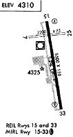
| A81-APT | ACTVT REIL RWY 15 & 33; MIRL 15/33 - CTAF. VASI RWY 15 & 33 ON CONSLY. |
| A82 | UNICOM ADZY AVBL 122.8 SR - SS. |
Runways
Runway Summary
| Runways: | 07/25 15/33 |
| Longest Runway: | 15/33 is 5950 ft (1814 m) long |
| Runways with an Instrument Approach: |
PGA Airport Runway Details
| Runway 07/25 | 2201 ft x 75 ft (671 m x 23 m) | |
| Runway Length Source: | 3RD PARTY SURVEY as of 01/15/2019 | |
| Surface: | Asphalt - Good condition - No special surface treatment | |
| Runway Pavement Class: | 2 /F/D/Y/T | |
Runway Weight Bearing Capacity (in thousands of pounds) |
||
| Dual Wheel Landing Gear: | 12.5 | |
Runway 07 |
Runway 25 |
|
Elevation: |
4243.1 | 4250.7 |
Latitude: |
36-55-44.9761N | 36-55-47.9769N |
Longitude: |
111-27-12.6786W | 111-26-45.8417W |
|
Runway True Alignment: |
082 | 262 |
Glide Path Angle: |
0.0 degrees | 0.0 degrees |
Traffic Pattern: |
Left | Right |
Runway Markings Type: |
Basic | Numbers Only |
Runway Markings Condition: |
Fair | Fair |
REIL: |
No | No |
Touchdown Lights: |
No | No |
Centerline Lights: |
No | No |
Threshold Elevation: |
4246.3 | |
Displaced Threshold: |
588 | |
Threshold Latitude: |
36-55-45.7796N | |
Threshold Longitude: |
111-27-05.5056W | |
Declared Distances |
||
Take Off Run Avbl. (TORA): |
2201 | 2201 |
Take Off Distance Avbl. (TODA): |
2201 | 2201 |
Actual Stop Dist. Avbl. (ASDA): |
2201 | 2201 |
Landing Dist. Avbl. (LDA): |
1613 | 2201 |
| Runway 15/33 | 5950 ft x 150 ft (1814 m x 46 m) | |
| Runway Length Source: | 3RD PARTY SURVEY as of 01/15/2019 | |
| Surface: | Asphalt - Good condition - No special surface treatment | |
| Runway Pavement Class: | 15 /F/C/W/T | |
| Runway Edge Lights: | Medium Intensity | |
Runway Weight Bearing Capacity (in thousands of pounds) |
||
| Single Wheel Landing Gear: | 65.0 | |
| Dual Wheel Landing Gear: | 90.0 | |
| Dual Tandem Wheel Landing Gear: | 190.0 | |
Runway 15 |
Runway 33 |
|
Elevation: |
4245.3 | 4316.6 |
Latitude: |
36-55-58.1494N | 36-55-00.2090N |
Longitude: |
111-26-58.4265W | 111-26-45.8528W |
|
Runway True Alignment: |
170 | 350 |
Glide Path Angle: |
3.0 degrees | 3.0 degrees |
Traffic Pattern: |
Left | Right |
Runway Markings Type: |
Nonprecision Instrument | Nonprecision Instrument |
Runway Markings Condition: |
Good | Good |
Visual Glide Slope Indicators: |
4-Box VASI On Left Side Of Runway | 4-Box VASI On Left Side Of Runway |
REIL: |
Yes | Yes |
Touchdown Lights: |
No | No |
Centerline Lights: |
No | No |
Threshold Crossing Height: |
52 | 30 |
Declared Distances |
||
Take Off Run Avbl. (TORA): |
5950 | 5950 |
Take Off Distance Avbl. (TODA): |
5950 | 5950 |
Actual Stop Dist. Avbl. (ASDA): |
5950 | 5950 |
Landing Dist. Avbl. (LDA): |
5950 | 5950 |
Services
Airframe Repair: |
Major |
Powerplant Repair: |
Major |
Bulk Oxygen: |
Low Pressure |
Fuel Available: |
100LL, Jet A |
Landing Fees: |
Yes |
Parking: |
Hangars and tiedowns available |
Maps & Diagrams
PGA Sectional
Flight Planning
at skyvector.com
at skyvector.com