Location
Latitude: |
41-28-41.8100N (41.478281) |
Longitude: |
073-08-06.6570W (-73.135183) |
Elevation: |
730.1 feet MSL (223 m MSL) |
Magnetic Variation: |
13.1 W (as of April 2024 from WMM2020 model) |
Time Zone: |
UTC -5.0 (Standard Time) UTC -4.0 (Daylight Savings Time) |
From City: |
03 N.M. N of Oxford, Connecticut |
Found On: |
New York Chart |
FAA Region: |
ANE |
Contacts
Manager: |
Publicly owned: |
| WILLIE MCBRIDE 300 CHRISTIAN ST OXFORD, CT 06478 203-264-8010 |
CONNECTICUT AIRPORT AUTHORITY SUITE 160, 334 ELLA GRASSO TURNPIKE WINDSOR LOCKS, CT 06096 860-292-2000 |
Operations
Airport Status: |
Operational |
Facility Use: |
Public |
Type: |
Airport |
Activation Date: |
12/1969 |
Control tower: |
Yes |
Attendance (Months/Days/Hours): |
Months/Days/Hours ALL/ALL/ALL |
Boundary ARTCC: |
ZBW (Boston) |
Responsible ARTCC: |
ZNY (New York) |
Lighting Schedule: |
SEE RMK |
Segmented Circle Indicator: |
Yes |
Traffic Pattern Altitude (MSL): |
1730 feet (527 m) |
NOTAMs Facility: |
OXC |
NOTAM-D Service: |
Yes |
International Airport of Entry: |
No |
Customs Landing Rights: |
Yes |
Military Landing Rights: |
Yes |
Civil/Military Joint Use: |
No |
Based Aircraft
| Single Engine: | 97 |
| Multi Engine: | 10 |
| Jet Engine: | 45 |
| GA Helicopters: | 5 |
Annual Operations (as of 09/30/2020)
| Total Operations: | 32664 | |
| Air Taxi: | 3126 | 9.6% |
| GA Local: | 12078 | 37.0% |
| GA Itinerant: | 16289 | 49.9% |
| Military Aircraft: | 1171 | 3.6% |
Communications
| CTAF: | 118.475 |
| Unicom: | 122.950 |
| Tower: | OXFORD 118.475 Hrs: 0600-2100 |
| Clearance Del.: | 121.65 |
| Ground: | 121.65 |
| Approach: | NEW YORK |
| Departure: | NEW YORK |
| ATIS: | 132.975 Hrs: 24 |
| AWOS-3PT: | 132.975 (203-262-1190) |
Fixed Based Operators (FBOs) & Fuel
(Click on a business for detail)
Please help us keep this information up to date. This is a FREE SERVICE just like everything else on Airport Guide! If you see that a business needs to be added, modified, or deleted please fill out our Update Form.
To add, modify, or delete a business click here.
Please help us keep this information up to date. This is a FREE SERVICE just like everything else on Airport Guide! If you see that a business needs to be added, modified, or deleted please fill out our Update Form.
Area Code: 203 |
| Business Name | Frequency | Phone | Fuel Grade |
|---|---|---|---|
| Keystone Aviation Services, Inc.
Update FBO info |
Unicom 122.7 | 264-6525 | 100LL, Jet A |
Flight Service Stations
| Primary | Alternate | |
| FSS on Field: | N | |
| FSS Name (ID): | Bridgeport(BDR) | |
| Frequency: | ||
| Toll Free Phone: | 1-800-WX-BRIEF |
Instrument Procedures / Charts
FAA Terminal Procedures valid from 0901Z 03/21/24 to 0901Z 04/18/24.
There are various types of charts available for an airport. They are listed in the Page Type column. Here is a legend for those types:
APD - Airport Diagram
DP - Departure Procedure Charts
HOT - Hot Spots
IAP - Instrument Approach Procedure Charts
MIN - Minimums
STAR - Standard Terminal Arrival Charts
| Page Type | Page Name | Volume | Action Since Last Cycle |
|---|---|---|---|
| APD | AIRPORT DIAGRAM | NE-1 | |
| IAP | ILS OR LOC RWY 36 | NE-1 | |
| IAP | RNAV (GPS) RWY 18 | NE-1 | |
| IAP | RNAV (GPS) RWY 36 | NE-1 | |
| MIN | ALTERNATE MINIMUMS | NE-1 | |
| MIN | TAKEOFF MINIMUMS | NE-1 | |
| STAR | BRIDGEPORT ONE | NE-1 | |
| STAR | DENNA THREE | NE-1 |
Terminal Procedures are only available for airports in several countries with more being added all the time. If you are looking for a specific country's charts, please send an email to support(at)airportguide.com stating the country name. This will be used to prioritize the implementation.
Navigation Aids (Navaids) near OXC
| Dist (NM) | ID | Morse Code | Name | Type | Freq | True Hdg | Mag Hdg |
|---|---|---|---|---|---|---|---|
| 5.8 | JWE | . _ _ _ . _ _ . | Clera | NDB | 362 | 169 | 182 |
| 17.2 | HVN | . . . . . . . _ _ . | New Haven | DME | 109.8 | 138 | 151 |
| 19.0 | BDR | _ . . . _ . . . _ . | Bridgeport | VOT | 109.25 | 178 | 191 |
| 19.1 | BDR | _ . . . _ . . . _ . | Bridgeport | VOR-DME | 108.80 | 178 | 191 |
| 22.2 | MAD | _ _ . _ _ . . | Madison | VOR-DME | 110.40 | 116 | 129 |
| 23.3 | CMK | _ . _ . _ _ _ . _ | Carmel | VOR-DME | 116.60 | 239 | 252 |
| 26.6 | HFD | . . . . . . _ . _ . . | Hartford | VOT | 108.20 | 54 | 67 |
| 27.2 | PWL | . _ _ . . _ _ . _ . . | Pawling | VOR-DME | 114.30 | 310 | 323 |
| 28.1 | HFD | . . . . . . _ . _ . . | Hartford | VOR-DME | 114.90 | 69 | 82 |
| 30.1 | OP | _ _ _ . _ _ . | Old Field Point Light | NDB | 316 | 178 | 191 |
| 32.8 | IGN | . . _ _ . _ . | Kingston | VOR-DME | 117.60 | 290 | 303 |
| 33.8 | BDL | _ . . . _ . . . _ . . | Bradley | VOT | 111.40 | 36 | 49 |
| 34.2 | BDL | _ . . . _ . . . _ . . | Bradley | VORTAC | 109.00 | 35 | 48 |
| 36.3 | CCC | _ . _ . _ . _ . _ . _ . | Calverton | VOR-DME | 114.55 | 155 | 168 |
| 37.7 | PO | . _ _ . _ _ _ | Meier | NDB | 403 | 279 | 292 |
| 41.0 | SKU | . . . _ . _ . . _ | Stanwyck | FAN MARKER | 274 | 287 | |
| 41.0 | SKU | . . . _ . _ . . _ | Stanwyck | NDB | 261 | 274 | 287 |
| 41.4 | ISP | . . . . . . _ _ . | Long Island Mac Arthur | VOT | 109.40 | 177 | 190 |
| 41.9 | DPK | _ . . . _ _ . _ . _ | Deer Park | VOR-DME | 117.70 | 190 | 203 |
| 43.2 | FO | . . _ . _ _ _ | Squir | NDB | 400 | 142 | 155 |
Nearby Airports with Fuel
Notices to Airmen (NOTAMS)
Remarks
| A110-1 | TGLS & PLAS PROHIBITED 2300-0700. |
| A110-100 | (E94) SAWRS. |
| A110-101 | TWY B, SOUTH OF TWY G, REFLECTORS ONLY. |
| A110-102 | TWY D CLSD. |
| A110-103 | FOR CD WHEN TWR CLSD CTC NEW YORK APCH AT 516-683-2449. |
| A110-104 | STEEP DROP OFF AFT SAFETY AREA NORTH & SOUTH OF TWY A. |
| A110-2 | PLA RWY 36 NA WHEN RWY 18 ACTV. |
| A110-3 | ARPT CLSD TO ACR OPS. |
| A110-4 | PAEW VCNTY RWY 18/36 SAFETY ZONE SUMMER ONLY SR-SS (MOWING IN PROG DLY). |
| A110-5 | RWY 36 CALM WIND RWY. |
| A110-6 | 748 FT ELEC TRANSMISSION TWRS RUNNING NE TO SW 0.2 MI N OF MID MKR. |
| A110-7 | DEER & BIRDS ON & INVOF ARPT. |
| A110-99 | ALL SOD AREAS CLSD. |
| A24 | LDG FEE FOR BUS/CORPORATE & REVENUE PRODUCING ACFT. |
| A43-18 | LGTS BAFFLED BYD 6 DEGS L OF CNTRLN. |
| A43-36 | LGTS BAFFLED DUE TO TREES & PWR LN TWR BYD 5 DEGS R OF CNTRLN. |
| A56-36 | PWR LN RUNS DGNLY ACRS THE APCH. |
| A81-APT | ACTVT REIL RWY 36; PAPI RWYS 18 & 36; HIRL RWY 18/36 - CTAF. |
| E147 | 973 FT AGL ACFT UP TO 12500 LBS; 1473 FT AGL ACFT OVR 12500 LBS. |
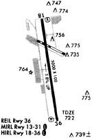
Runways
Runway Summary
| Runways: | 18/36 |
| Longest Runway: | 18/36 is 5801 ft (1768 m) long |
| Runways with an Instrument Approach: | 36 |
OXC Airport Runway Details
| Runway 18/36 | 5801 ft x 100 ft (1768 m x 30 m) | |
| Runway Length Source: | 3RD PARTY SURVEY as of 06/05/2018 | |
| Surface: | Asphalt - Excellent condition - Saw-cut or plastic grooved | |
| Runway Edge Lights: | High Intensity | |
Runway Weight Bearing Capacity (in thousands of pounds) |
||
| Single Wheel Landing Gear: | 50.0 | |
| Dual Wheel Landing Gear: | 85.0 | |
| Dual Tandem Wheel Landing Gear: | 145.0 | |
Runway 18 |
Runway 36 |
|
Elevation: |
730.1 | 680.1 |
Latitude: |
41-29-10.0912N | 41-28-13.5292N |
Longitude: |
073-08-12.7684W | 073-08-00.5480W |
|
Runway True Alignment: |
171 | 351 |
ILS Type: |
ILS/DME | |
Glide Path Angle: |
3.0 degrees | 3.0 degrees |
Traffic Pattern: |
Right | Left |
Runway Markings Type: |
Precision Instrument | Precision Instrument |
Runway Markings Condition: |
Good | Good |
Object at End: |
PLINE | |
Object Height: |
50 | |
Object Marked/Lighted?: |
Lighted | |
Distance from End: |
1300 | 1000 |
Object Centerline Offset: |
600 ft. right of centerline | |
Visual Glide Slope Indicators: |
4-Light PAPI On Left Side Of Runway | 4-Light PAPI On Left Side Of Runway |
REIL: |
No | Yes |
Threshold Crossing Height: |
47 | 56 |
Threshold Elevation: |
685.9 | |
Displaced Threshold: |
500 | |
Threshold Latitude: |
41-28-18.4052N | |
Threshold Longitude: |
073-08-01.6012W | |
Declared Distances |
||
Take Off Run Avbl. (TORA): |
5801 | 5801 |
Take Off Distance Avbl. (TODA): |
5801 | 5801 |
Actual Stop Dist. Avbl. (ASDA): |
5801 | 5801 |
Landing Dist. Avbl. (LDA): |
5801 | 5301 |
Services
Bottled Oxygen: |
None |
Bulk Oxygen: |
None |
Fuel Available: |
100LL |
Landing Fees: |
No |
Parking: |
Tiedowns available |
Maps & Diagrams
OXC Sectional
Flight Planning
at skyvector.com
at skyvector.com