Location
Latitude: |
34-03-21.6510N (34.056014) |
Longitude: |
117-36-04.2750W (-117.601188) |
Elevation: |
944.1 feet MSL (288 m MSL) |
Magnetic Variation: |
11.4 E (as of April 2024 from WMM2020 model) |
Time Zone: |
UTC -8.0 (Standard Time) UTC -7.0 (Daylight Savings Time) |
From City: |
02 N.M. E of Ontario, California |
Found On: |
Los Angeles Chart |
FAA Region: |
AWP |
Contacts
Manager: |
Publicly owned: |
| ATIF ELKADI 1923 EAST AVION STREET ONTARIO, CA 91761 909-544-5300 |
ONTARIO INTL AIRPORT AUTHORITY 1923 EAST AVION STREET ONTARIO, CA 91761 909-544-5300 |
Operations
Airport Status: |
Operational |
Facility Use: |
Public |
Type: |
Airport |
Activation Date: |
04/1940 |
Control tower: |
Yes |
Attendance (Months/Days/Hours): |
Months/Days/Hours ALL/ALL/ALL |
Boundary ARTCC: |
ZLA (Los Angeles) |
Responsible ARTCC: |
ZLA (Los Angeles) |
Segmented Circle Indicator: |
No |
Traffic Pattern Altitude (MSL): |
1944 feet (593 m) |
NOTAMs Facility: |
ONT |
NOTAM-D Service: |
Yes |
International Airport of Entry: |
No |
Customs Landing Rights: |
No |
Military Landing Rights: |
Yes |
Civil/Military Joint Use: |
No |
Aircraft Rescue and Firefighting: |
Class I ARFF Index: D Air Carrier Service: Scheduled Certification Date: 05/1973 |
Based Aircraft
| Single Engine: | 1 |
| Jet Engine: | 13 |
| GA Helicopters: | 1 |
Annual Operations (as of 01/05/2023)
| Total Operations: | 109014 | |
| Commercial: | 78271 | 71.8% |
| Air Taxi: | 12629 | 11.6% |
| GA Local: | 8528 | 7.8% |
| GA Itinerant: | 9103 | 8.4% |
| Military Aircraft: | 483 | 0.4% |
Communications
| Tower: | ONTARIO 120.6 360.775 Hrs: 24 |
| Clearance Del.: | 132.9 |
| Ground: | 121.9 257.8 |
| Approach: | SOCAL |
| Departure: | SOCAL |
| ATIS: | 124.25 Hrs: 24 |
| ASOS: | (909-937-2186) |
| EMERG: | 121.5 |
| EMERG: | 243.0 |
Fixed Based Operators (FBOs) & Fuel
(Click on a business for detail)
Please help us keep this information up to date. This is a FREE SERVICE just like everything else on Airport Guide! If you see that a business needs to be added, modified, or deleted please fill out our Update Form.
To add, modify, or delete a business click here.
Please help us keep this information up to date. This is a FREE SERVICE just like everything else on Airport Guide! If you see that a business needs to be added, modified, or deleted please fill out our Update Form.
Area Code: 909 |
| Business Name | Frequency | Phone | Fuel Grade |
|---|---|---|---|
| KMR Aviation
Update FBO info |
605-6366 | ||
| Mercury Air Center
Update FBO info |
Arinc 131.6 | 390-2370 | 100LL, Jet A |
Flight Service Stations
| Primary | Alternate | |
| FSS on Field: | N | |
| FSS Name (ID): | Riverside(RAL) | |
| Frequency: | ||
| Toll Free Phone: | 1-800-WX-BRIEF |
Instrument Procedures / Charts
FAA Terminal Procedures valid from 0901Z 03/21/24 to 0901Z 04/18/24.
There are various types of charts available for an airport. They are listed in the Page Type column. Here is a legend for those types:
APD - Airport Diagram
DP - Departure Procedure Charts
HOT - Hot Spots
IAP - Instrument Approach Procedure Charts
MIN - Minimums
STAR - Standard Terminal Arrival Charts
Terminal Procedures are only available for airports in several countries with more being added all the time. If you are looking for a specific country's charts, please send an email to support(at)airportguide.com stating the country name. This will be used to prioritize the implementation.
Navigation Aids (Navaids) near ONT
| Dist (NM) | ID | Morse Code | Name | Type | Freq | True Hdg | Mag Hdg |
|---|---|---|---|---|---|---|---|
| 9.0 | PDZ | . _ _ . _ . . _ _ . . | Paradise | VORTAC | 112.20 | 156 | 145 |
| 9.3 | POM | . _ _ . _ _ _ _ _ | Pomona | VORTAC | 110.40 | 278 | 267 |
| 9.7 | RAL | . _ . . _ . _ . . | Riverside | VOR | 108.60 | 128 | 117 |
| 11.7 | SB | . . . _ . . . | Petis | NDB | 397 | 89 | 78 |
| 18.5 | RIV | . _ . . . . . . _ | March | TACAN | 113.00 | 118 | 107 |
| 21.5 | EMT | . _ _ _ | El Monte | NDB | 359 | 275 | 264 |
| 23.7 | ELB | . . _ . . _ . . . | El Toro | VOR-DME | 117.20 | 195 | 184 |
| 26.4 | SNA | . . . _ . . _ | Santa Ana | VOT | 110.00 | 210 | 199 |
| 26.7 | HDF | . . . . _ . . . . _ . | Homeland | VOR | 112.05 | 128 | 117 |
| 27.9 | SLI | . . . . _ . . . . | Seal Beach | VORTAC | 115.70 | 234 | 223 |
| 29.7 | LG | . _ . . _ _ . | Becca | NDB | 233 | 232 | 221 |
| 33.7 | CPM | _ . _ . . _ _ . _ _ | Compton | NDB | 378 | 252 | 241 |
| 33.9 | VCV | . . . _ _ . _ . . . . _ | Victorville | VOR-DME | 109.05 | 17 | 6 |
| 39.5 | UR | . . _ . _ . | Vinee | NDB | 253 | 282 | 271 |
| 41.1 | LAX | . _ . . . _ _ . . _ | San Pedro Hill | VOT | 113.90 | 243 | 232 |
| 41.4 | PMD | . _ _ . _ _ _ . . | Palmdale | VORTAC | 114.50 | 326 | 315 |
| 42.0 | LAX | . _ . . . _ _ . . _ | Los Angeles | VORTAC | 113.60 | 260 | 249 |
| 42.1 | PAI | . _ _ . . _ . . | Pacoima | NDB | 370 | 287 | 276 |
| 42.6 | SMO | . . . _ _ _ _ _ | Santa Monica | VOR-DME | 110.80 | 266 | 255 |
| 45.4 | VNY | . . . _ _ . _ . _ _ | Van Nuys | VOR-DME | 113.10 | 283 | 272 |
Nearby Airports with Fuel
Notices to Airmen (NOTAMS)
Remarks
| A110-22 | FBO ON FREQ 130.75. |
| A110-38 | WILDLIFE HAZARD MGT PLAN IN EFFECT; POTENTIAL BIRD HAZARDS MAY EXIST ON AND INVOF ARPT; BE ALERT TO LARGE NUMBERS OF STARLINGS AND CROWS POSSIBLE ON APCH TO RY 26L AND RY 26R, HAWKS, EAGLES, FALCONS AND OWLS SPOTTED ON OCCASION. |
| A110-39 | TWY S-4 RSTD TO ACFT WITH WINGSPAN 117 FT OR SMALLER. |
| A110-40 | PILOTS SHOULD USE JUDGEMENTAL OVERSTEER ON TWY S-4. |
| A110-43 | NOISE ABATEMENT PROCEDURES IN EFFECT; FULL-LENGTH TURBOJET DEP ENCOURAGED, NIGHTLY PREFERENTIAL RWY USAGE, 2200-0700. |
| A110-44 | EASTBOUND B747, B777, A330, A340 OR LARGER ACFT ON TWY S PROHIBITED FROM NORTHBOUND TURNS ONTO TWY K. |
| A110-45 | B747, B777, A330, A340 OR LARGER ACFT ON TWY S PROHIBITED FROM NORTHBOUND TURNS ONTO TWY P. |
| A110-46 | ACFT PRKG AND CONTR GND SVCS ARE LTD FOR UNSKED OPS. FOR SKED INFO CALL AIRFIELD OPS (909) 214-7682/7683. |
| A110-48 | TWY Y EAST OF TWY W IS A NON-MOVEMENT AREA; ALL ACFT CTC RAMP CTL 131.325 FOR ACCESS. |
| A110-49 | ALL MILITARY AND GENERAL AVIATION (FIXED OR ROTOR WING) ACFT OPS ARE RESTRICTED TO FBO FACILITIES WITH ADVANCE COORDINATION; OVERNIGHT TIEDOWN AND PARKING FEE. |
| A110-50 | PTNS OF TWY S IN THE VCY OF TWY F ARE NOT VSB FM ATCT; PILOTS USE CTN ENTERING TWY F SOUTH OF TWY S. |
| A110-52 | ACFT ACCESS TO TWY R FROM RWY 26R PROHIBITED |
| A110-54 | TWY F SOUTH OF TWY S RSTRD TO ACFT WITH 117 FT WINGSPAN AND SMALLER. TWY F SOUTH OF RWY 26L RSTRD TO ACFT WITH 180 FT WINGSPAN. |
| A57-08L | APCH RATIO 50:1 TO DSPLCD THR. |
| E80 | US CUSTOMS USER FEE ARPT. |
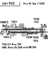
Runways
Runway Summary
| Runways: | 08L/26R 08R/26L |
| Longest Runway: | 08L/26R is 12197 ft (3718 m) long |
| Runways with an Instrument Approach: | 08L, 26R, 26L |
ONT Airport Runway Details
| Runway 08L/26R | 12197 ft x 150 ft (3718 m x 46 m) | |
| Runway Length Source: | 3RD PARTY SURVEY as of 06/05/2019 | |
| Surface: | Concrete - Good condition - Saw-cut or plastic grooved | |
| Runway Pavement Class: | 102/R/B/W/T | |
| Runway Edge Lights: | High Intensity | |
Runway Weight Bearing Capacity (in thousands of pounds) |
||
| Single Wheel Landing Gear: | 30.0 | |
| Dual Wheel Landing Gear: | 200.0 | |
| Dual Tandem Wheel Landing Gear: | 560.0 | |
| Dual Dual Tandem Wheel Landing Gear: | 850.0 | |
Runway 08L |
Runway 26R |
|
Elevation: |
943.2 | 931.8 |
Latitude: |
34-03-24.7651N | 34-03-24.8259N |
Longitude: |
117-37-22.1586W | 117-34-57.2057W |
|
Runway True Alignment: |
090 | 270 |
ILS Type: |
ILS | ILS/DME |
Glide Path Angle: |
3.0 degrees | 3.0 degrees |
Traffic Pattern: |
Right | |
Runway Markings Type: |
Precision Instrument | Precision Instrument |
Runway Markings Condition: |
Good | Good |
Object at End: |
RR | POLE |
Object Height: |
20 | 40 |
Distance from End: |
600 | 2050 |
Object Centerline Offset: |
250 ft. right of centerline | 400 ft. right of centerline |
Visual Glide Slope Indicators: |
4-Light PAPI On Left Side Of Runway | 4-Light PAPI On Left Side Of Runway |
Runway Visual Range (RVR): |
Touchdown, Midfield, Rollout | Touchdown, Midfield, Rollout |
Approach Light System: |
1,400 Foot Medium Intensity Approach Lighting System With Runway Alignment Indicator Lights | Standard 2,400 Foot High Intensity Approach Lighting System With Sequenced Flashers, Cat. II or III Config. |
REIL: |
No | No |
Touchdown Lights: |
Yes | Yes |
Centerline Lights: |
Yes | Yes |
Threshold Crossing Height: |
62 | 75 |
Threshold Elevation: |
944.0 | |
Displaced Threshold: |
997 | |
Threshold Latitude: |
34-03-24.7725N | |
Threshold Longitude: |
117-37-10.3075W | |
Declared Distances |
||
Take Off Run Avbl. (TORA): |
12197 | 12197 |
Take Off Distance Avbl. (TODA): |
12197 | 12197 |
Actual Stop Dist. Avbl. (ASDA): |
12197 | 12197 |
Landing Dist. Avbl. (LDA): |
11200 | 12197 |
| Runway 08R/26L | 10200 ft x 150 ft (3109 m x 46 m) | |
| Runway Length Source: | 3RD PARTY SURVEY as of 06/05/2019 | |
| Surface: | Concrete - Good condition - Saw-cut or plastic grooved | |
| Runway Pavement Class: | 70 /R/B/W/T | |
| Runway Edge Lights: | High Intensity | |
Runway Weight Bearing Capacity (in thousands of pounds) |
||
| Single Wheel Landing Gear: | 30.0 | |
| Dual Wheel Landing Gear: | 200.0 | |
| Dual Tandem Wheel Landing Gear: | 560.0 | |
| Dual Dual Tandem Wheel Landing Gear: | 850.0 | |
Runway 08R |
Runway 26L |
|
Elevation: |
936.0 | 926.2 |
Latitude: |
34-03-17.8579N | 34-03-17.9013N |
Longitude: |
117-36-58.4219W | 117-34-57.1985W |
|
Runway True Alignment: |
090 | 270 |
ILS Type: |
ILS/DME | |
Glide Path Angle: |
3.0 degrees | 3.0 degrees |
Traffic Pattern: |
Right | Left |
Runway Markings Type: |
Precision Instrument | Precision Instrument |
Runway Markings Condition: |
Good | Good |
Object at End: |
POLE | |
Object Height: |
40 | |
Distance from End: |
2050 | |
Object Centerline Offset: |
250 ft. right of centerline | 400 ft. right of centerline |
Visual Glide Slope Indicators: |
4-Light PAPI On Left Side Of Runway | 4-Light PAPI On Right Side Of Runway |
Runway Visual Range (RVR): |
Touchdown, Midfield, Rollout | Touchdown, Midfield, Rollout |
Approach Light System: |
Standard 2,400 Foot High Intensity Approach Lighting System With Sequenced Flashers, Cat. II or III Config. | |
REIL: |
No | No |
Touchdown Lights: |
No | Yes |
Centerline Lights: |
Yes | Yes |
Threshold Crossing Height: |
65 | 74 |
Declared Distances |
||
Take Off Run Avbl. (TORA): |
10200 | 10200 |
Take Off Distance Avbl. (TODA): |
10200 | 10200 |
Actual Stop Dist. Avbl. (ASDA): |
10200 | 10200 |
Landing Dist. Avbl. (LDA): |
10200 | 10200 |
Services
Airframe Repair: |
None |
Powerplant Repair: |
None |
Bottled Oxygen: |
None |
Bulk Oxygen: |
None |
Fuel Available: |
100LL |
Landing Fees: |
No |
Parking: |
Tiedowns available |
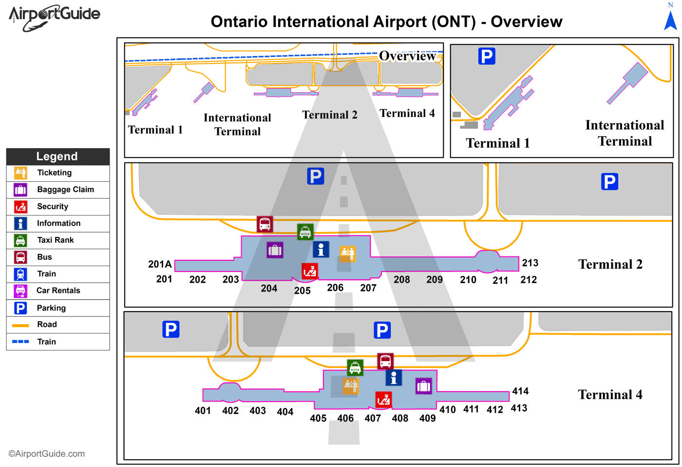
Maps & Diagrams
ONT Sectional
Flight Planning
at skyvector.com
at skyvector.com