Location
Latitude: |
42-31-29.2000N (42.524778) |
Longitude: |
075-03-52.1000W (-75.064472) |
Elevation: |
1763.3 feet MSL (537 m MSL) |
Magnetic Variation: |
12.4 W (as of April 2024 from WMM2020 model) |
Time Zone: |
UTC -5.0 (Standard Time) UTC -4.0 (Daylight Savings Time) |
From City: |
03 N.M. N of Oneonta, New York |
Found On: |
New York Chart |
FAA Region: |
AEA |
Contacts
Manager: |
Publicly owned: |
| KERRIANN HARRINGTON 391 AIRPORT RD ONEONTA, NY 13820 (607) 431-1076 |
CITY OF ONEONTA 258 MAIN STREET ONEONTA, NY 13820 607-431-1076 |
Operations
Airport Status: |
Operational |
Facility Use: |
Public |
Type: |
Airport |
Control tower: |
No |
Attendance (Months/Days/Hours): |
Months/Days/Hours ALL/MON-FRI/0900-1700 |
Boundary ARTCC: |
ZBW (Boston) |
Responsible ARTCC: |
ZBW (Boston) |
Lighting Schedule: |
SEE RMK |
Segmented Circle Indicator: |
Yes |
Traffic Pattern Altitude (MSL): |
2763 feet (842 m) |
NOTAMs Facility: |
BUF |
NOTAM-D Service: |
Yes |
International Airport of Entry: |
No |
Customs Landing Rights: |
Yes |
Military Landing Rights: |
Yes |
Civil/Military Joint Use: |
No |
Based Aircraft
| Single Engine: | 14 |
| Multi Engine: | 1 |
| GA Helicopters: | 1 |
Annual Operations (as of 09/10/2020)
| Total Operations: | 21600 | |
| Air Taxi: | 3000 | 13.9% |
| GA Local: | 15000 | 69.4% |
| GA Itinerant: | 3500 | 16.2% |
| Military Aircraft: | 100 | 0.5% |
Communications
| CTAF: | 122.800 |
| Unicom: | 122.800 |
| AWOS-3: | 119.575 (607-643-0253) |
- APCH/DEP SVC PRVDD BY BOSTON ARTCC ON FREQS 133.25/279.5 (ROCKDALE RCAG).
Fixed Based Operators (FBOs) & Fuel
(Click on a business for detail)
Please help us keep this information up to date. This is a FREE SERVICE just like everything else on Airport Guide! If you see that a business needs to be added, modified, or deleted please fill out our Update Form.
To add, modify, or delete a business click here.
Please help us keep this information up to date. This is a FREE SERVICE just like everything else on Airport Guide! If you see that a business needs to be added, modified, or deleted please fill out our Update Form.
Area Code: 607 |
| Business Name | Frequency | Phone | Fuel Grade |
|---|
Flight Service Stations
| Primary | Alternate | |
| FSS on Field: | N | |
| FSS Name (ID): | Buffalo(BUF) | |
| Frequency: | ||
| Toll Free Phone: | 1-800-WX-BRIEF |
Instrument Procedures / Charts
FAA Terminal Procedures valid from 0901Z 03/21/24 to 0901Z 04/18/24.
There are various types of charts available for an airport. They are listed in the Page Type column. Here is a legend for those types:
APD - Airport Diagram
DP - Departure Procedure Charts
HOT - Hot Spots
IAP - Instrument Approach Procedure Charts
MIN - Minimums
STAR - Standard Terminal Arrival Charts
| Page Type | Page Name | Volume | Action Since Last Cycle |
|---|---|---|---|
| IAP | RNAV (GPS) RWY 06 | NE-2 | |
| IAP | RNAV (GPS) RWY 24 | NE-2 | |
| MIN | TAKEOFF MINIMUMS | NE-2 |
Terminal Procedures are only available for airports in several countries with more being added all the time. If you are looking for a specific country's charts, please send an email to support(at)airportguide.com stating the country name. This will be used to prioritize the implementation.
Navigation Aids (Navaids) near ONH
| Dist (NM) | ID | Morse Code | Name | Type | Freq | True Hdg | Mag Hdg |
|---|---|---|---|---|---|---|---|
| 5.0 | OZ | _ _ _ _ _ . . | Kring | NDB | 279 | 43 | 55 |
| 8.5 | RKA | . _ . _ . _ . _ | Rockdale | VOR-DME | 112.60 | 245 | 257 |
| 21.3 | DNY | _ . . _ . _ . _ _ | Delancey | VOR-DME | 112.10 | 167 | 179 |
| 29.9 | HNK | . . . . _ . _ . _ | Hancock | VOR-DME | 116.80 | 202 | 214 |
| 30.4 | UCA | . . _ _ . _ . . _ | Utica | TACAN | 111.20 | 351 | 363 |
| 37.2 | GGT | _ _ . _ _ . _ | Georgetown | TACAN | 117.80 | 295 | 307 |
| 43.1 | JJH | . _ _ _ . _ _ _ . . . . | Johnstown | NDB | 523 | 48 | 61 |
| 44.5 | BG | _ . . . _ _ . | Smite | NDB | 332 | 235 | 247 |
| 46.4 | MS | _ _ . . . | Monga | NDB | 359 | 168 | 180 |
| 52.4 | CFB | _ . _ . . . _ . _ . . . | Binghamton | VOR-DME | 112.20 | 245 | 257 |
| 53.7 | HEU | . . . . . . . _ | Hunter | NDB | 356 | 68 | 81 |
| 56.4 | ALB | . _ . _ . . _ . . . | Albany | VOT | 108.20 | 76 | 89 |
| 57.3 | ALB | . _ . _ . . _ . . . | Albany | VORTAC | 115.30 | 76 | 89 |
| 58.0 | IT | . . _ | Vrnah | NDB | 266 | 264 | 276 |
| 61.6 | PFH | . _ _ . . . _ . . . . . | Philmont | NDB | 272 | 104 | 117 |
| 61.7 | ITH | . . _ . . . . | Ithaca | DME | 111.8 | 268 | 280 |
| 63.0 | SYR | . . . _ . _ _ . _ . | Syracuse | VORTAC | 117.00 | 307 | 319 |
| 65.6 | LHY | . _ . . . . . . _ . _ _ | Lake Henry | VORTAC | 110.80 | 196 | 208 |
| 70.2 | HUO | . . . . . . _ _ _ _ | Huguenot | VOR-DME | 116.10 | 162 | 174 |
| 71.2 | FZ | . . _ . _ _ . . | Falln | NDB | 220 | 310 | 322 |
Nearby Airports with Fuel
Notices to Airmen (NOTAMS)
Remarks
| A110*G | THIS AIRPORT HAS BEEN SURVEYED BY THE NATIONAL GEODETIC SURVEY. |
| A110-2 | (E94) SAWRS |
| A110-3 | FOR CD CTC BOSTON ARTCC AT 603-879-6859. |
| A48-24 | RWY 24 REILS OTS |
| A58-06 | 7 FT BERM 150 FT RIGHT AND PARALLEL TO RY 6 PRIMARY SURFACE. |
| A80 | BCN TWR PARTIALLY OBSCURED BY TREES. |
| A81-APT | ACTVT MALS RY 24; REIL RY 06/24; VASI RY 06; PAPI RY 24; MIRL RY 06/24 - CTAF. |
Runways
Runway Summary
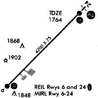
| Runways: | 06/24 |
| Longest Runway: | 06/24 is 4199 ft (1280 m) long |
| Runways with an Instrument Approach: | 24 |
ONH Airport Runway Details
| Runway 06/24 | 4199 ft x 75 ft (1280 m x 23 m) | |
| Surface: | Asphalt - Excellent condition - No special surface treatment | |
| Runway Edge Lights: | Medium Intensity | |
Runway Weight Bearing Capacity (in thousands of pounds) |
||
| Single Wheel Landing Gear: | 12.0 | |
Runway 06 |
Runway 24 |
|
Elevation: |
1762.8 | 1750.1 |
Latitude: |
42-31-14.2729N | 42-31-44.0289N |
Longitude: |
075-04-11.5910W | 075-03-32.5419W |
|
Runway True Alignment: |
044 | 224 |
ILS Type: |
LOCALIZER | |
Glide Path Angle: |
3.0 degrees | 3.0 degrees |
Traffic Pattern: |
Left | Left |
Runway Markings Type: |
Nonprecision Instrument | Nonprecision Instrument |
Runway Markings Condition: |
Good | Good |
Object at End: |
TREE | FENCE |
Object Height: |
68 | 121 |
Object Marked/Lighted?: |
Marked | |
Distance from End: |
818 | 2442 |
Object Centerline Offset: |
315 ft. right of centerline | 518 ft. left of centerline |
Visual Glide Slope Indicators: |
4-Box VASI On Right Side Of Runway | 2-Light PAPI On Left Side Of Runway |
Approach Light System: |
1,400 Foot Medium Intensity Approach Lighting System | |
REIL: |
Yes | Yes |
Touchdown Lights: |
No | No |
Centerline Lights: |
No | No |
Threshold Crossing Height: |
30 | 51 |
Services
Airframe Repair: |
Major |
Powerplant Repair: |
Major |
Bottled Oxygen: |
Low Pressure |
Bulk Oxygen: |
None |
Fuel Available: |
100LL, Jet A |
Landing Fees: |
No |
Parking: |
Hangars and tiedowns available |
Maps & Diagrams
ONH Sectional
Flight Planning
at skyvector.com
at skyvector.com