Location
Latitude: |
33-27-24.9041N (33.456918) |
Longitude: |
080-51-33.8640W (-80.859407) |
Elevation: |
195.4 feet MSL (60 m MSL) |
Magnetic Variation: |
7.7 W (as of April 2024 from WMM2020 model) |
Time Zone: |
UTC -5.0 (Standard Time) UTC -4.0 (Daylight Savings Time) |
From City: |
02 N.M. S of Orangeburg, South Carolina |
Found On: |
Charlotte Chart |
FAA Region: |
ASO |
Contacts
Manager: |
Publicly owned: |
| BETTY BAKER 1811 AIRPORT ROAD ORANGEBURG, SC 29115 803-534-5545 |
CITY OF ORANGEBURG PO BOX 387 ORANGEBURG, SC 29115 (803) 533-6010 |
Operations
Airport Status: |
Operational |
Facility Use: |
Public |
Type: |
Airport |
Activation Date: |
11/1937 |
Control tower: |
No |
Attendance (Months/Days/Hours): |
Months/Days/Hours ALL/MON-FRI/0700-1700 |
Boundary ARTCC: |
ZJX (Jacksonville) |
Responsible ARTCC: |
ZJX (Jacksonville) |
Lighting Schedule: |
SEE RMK |
Segmented Circle Indicator: |
Yes |
Traffic Pattern Altitude (MSL): |
1195 feet (364 m) |
NOTAMs Facility: |
OGB |
NOTAM-D Service: |
Yes |
International Airport of Entry: |
No |
Customs Landing Rights: |
No |
Military Landing Rights: |
Yes |
Civil/Military Joint Use: |
No |
Based Aircraft
| Single Engine: | 26 |
| Multi Engine: | 9 |
| Jet Engine: | 3 |
Annual Operations (as of 06/10/2021)
| Total Operations: | 6500 | |
| Air Taxi: | 197 | 3.0% |
| GA Local: | 2678 | 41.2% |
| GA Itinerant: | 3584 | 55.1% |
| Military Aircraft: | 41 | 0.6% |
Communications
| CTAF: | 122.700 |
| Unicom: | 122.700 |
| Approach: | COLUMBIA 124.15 124.15 |
| Departure: | COLUMBIA 124.15 124.15 |
| ASOS: | 118.525 (803-536-3901) |
- APCH/DEP SVC PRVDD BY CAE (COLUMBIA METROPOLITAN, COLUMBIA SC) 124.15/338.2.
Fixed Based Operators (FBOs) & Fuel
(Click on a business for detail)
Please help us keep this information up to date. This is a FREE SERVICE just like everything else on Airport Guide! If you see that a business needs to be added, modified, or deleted please fill out our Update Form.
To add, modify, or delete a business click here.
Please help us keep this information up to date. This is a FREE SERVICE just like everything else on Airport Guide! If you see that a business needs to be added, modified, or deleted please fill out our Update Form.
Area Code: 803 |
| Business Name | Frequency | Phone | Fuel Grade |
|---|---|---|---|
| Orangeburg Municipal Airport
Update FBO info |
Unicom 122.7 | 534-5545, after hours call 531-4442 or 655-7767 | 100LL, Jet A |
Flight Service Stations
| Primary | Alternate | |
| FSS on Field: | N | |
| FSS Name (ID): | Anderson(AND) | |
| Frequency: | ||
| Toll Free Phone: | 1-800-WX-BRIEF |
Instrument Procedures / Charts
FAA Terminal Procedures valid from 0901Z 03/21/24 to 0901Z 04/18/24.
There are various types of charts available for an airport. They are listed in the Page Type column. Here is a legend for those types:
APD - Airport Diagram
DP - Departure Procedure Charts
HOT - Hot Spots
IAP - Instrument Approach Procedure Charts
MIN - Minimums
STAR - Standard Terminal Arrival Charts
| Page Type | Page Name | Volume | Action Since Last Cycle |
|---|---|---|---|
| IAP | RNAV (GPS) RWY 05 | SE-2 | |
| IAP | RNAV (GPS) RWY 17 | SE-2 | |
| IAP | RNAV (GPS) RWY 23 | SE-2 | |
| IAP | RNAV (GPS) RWY 35 | SE-2 | |
| MIN | ALTERNATE MINIMUMS | SE-2 | |
| MIN | TAKEOFF MINIMUMS | SE-2 |
Terminal Procedures are only available for airports in several countries with more being added all the time. If you are looking for a specific country's charts, please send an email to support(at)airportguide.com stating the country name. This will be used to prioritize the implementation.
Navigation Aids (Navaids) near OGB
| Dist (NM) | ID | Morse Code | Name | Type | Freq | True Hdg | Mag Hdg |
|---|---|---|---|---|---|---|---|
| 0.1 | EDS | . _ . . . . . | Edisto | VOR-DME | 111.40 | 130 | 138 |
| 20.6 | VAN | . . . _ . _ _ . | Vance | VORTAC | 110.40 | 86 | 94 |
| 25.9 | CAE | _ . _ . . _ . | Columbia | VORTAC | 114.70 | 338 | 346 |
| 28.2 | MMT | _ _ _ _ _ | Mc Entire | VORTAC | 113.20 | 5 | 13 |
| 33.6 | MNI | _ _ _ . . . | Manning | NDB | 381 | 76 | 84 |
| 33.7 | RBW | . _ . _ . . . . _ _ | Walterboro | NDB | 221 | 160 | 168 |
| 34.4 | ALD | . _ . _ . . _ . . | Allendale | VOR | 116.70 | 219 | 227 |
| 36.2 | CA | _ . _ . . _ | Murry | NDB | 362 | 327 | 335 |
| 36.9 | SSC | . . . . . . _ . _ . | Shaw | TACAN | 110.10 | 32 | 40 |
| 37.6 | DYB | _ . . _ . _ _ _ . . . | Dorchester County | NDB | 365 | 128 | 136 |
| 40.6 | SMS | . . . _ _ . . . | Sumter | NDB | 252 | 37 | 45 |
| 42.5 | AIK | . _ . . _ . _ | Aiken | NDB | 347 | 286 | 294 |
| 47.9 | CH | _ . _ . . . . . | Ashly | NDB | 329 | 126 | 134 |
| 52.6 | CKI | _ . _ . _ . _ . . | Kingstree | NDB | 404 | 72 | 80 |
| 52.7 | CHS | _ . _ . . . . . . . . | Charleston | VOT | 111.00 | 128 | 136 |
| 53.0 | FDW | . . _ . _ . . . _ _ | Winnsboro | NDB | 414 | 346 | 354 |
| 53.3 | CHS | _ . _ . . . . . . . . | Charleston | VORTAC | 113.50 | 129 | 137 |
| 55.4 | AG | . _ _ _ . | Bushe | NDB | 233 | 259 | 266 |
| 56.9 | EMR | . _ _ . _ . | Emory | NDB | 385 | 270 | 277 |
| 59.1 | NBC | _ . _ . . . _ . _ . | Beaufort | TACAN | 110.50 | 173 | 181 |
Nearby Airports with Fuel
Notices to Airmen (NOTAMS)
Remarks
| A110-2 | RY 05 HAS MKD PLINES 1000 FT FROM THLD. |
| A110-3 | GCO AVBL ON FREQ 125.675 MONITORED BY COLUMBIA APCH CTL. |
| A110-4 | FOR CD IF UNA VIA GCO CTC JACKSONVILLE ARTCC AT 904-845-1592. |
| A17 | NOT MANNED ON SUNDAY - FOR ASST PHONE AMGR. |
| A43-05 | RWY 5 VASI OTS INDEFINITELY |
| A81-APT | ACTVT ODALS RY 17/35, REIL RY 23 & RY 17/35; MIRL RY 05/23 & RY 17/35 - CTAF. PAPI RYS 17 AND 35 OPER CONT. |
| E111 | EXISTED PRIOR TO 1958. |
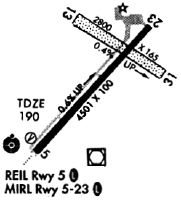
Runways
Runway Summary
| Runways: | 05/23 17/35 |
| Longest Runway: | 17/35 is 5399 ft (1646 m) long |
| Runways with an Instrument Approach: |
OGB Airport Runway Details
| Runway 05/23 | 4508 ft x 100 ft (1374 m x 30 m) | |
| Runway Length Source: | 3RD PARTY SURVEY as of 03/19/2008 | |
| Surface: | Asphalt - Good condition - No special surface treatment | |
| Runway Edge Lights: | Medium Intensity | |
Runway Weight Bearing Capacity (in thousands of pounds) |
||
| Single Wheel Landing Gear: | 30.0 | |
| Dual Wheel Landing Gear: | 50.0 | |
Runway 05 |
Runway 23 |
|
Elevation: |
170.3 | 195.1 |
Latitude: |
33-27-22.9794N | 33-27-55.9553N |
Longitude: |
080-51-49.9914W | 080-51-14.1737W |
|
Runway True Alignment: |
042 | 222 |
Glide Path Angle: |
3.0 degrees | 0.0 degrees |
Traffic Pattern: |
Right | Left |
Runway Markings Type: |
Nonprecision Instrument | Nonprecision Instrument |
Runway Markings Condition: |
Good | Good |
Visual Glide Slope Indicators: |
4-Box VASI On Left Side Of Runway | |
REIL: |
No | Yes |
Threshold Crossing Height: |
21 |
| Runway 17/35 | 5399 ft x 100 ft (1646 m x 30 m) | |
| Runway Length Source: | 3RD PARTY SURVEY as of 03/19/2008 | |
| Surface: | Asphalt - Good condition - No special surface treatment | |
| Runway Edge Lights: | Medium Intensity | |
Runway Weight Bearing Capacity (in thousands of pounds) |
||
| Single Wheel Landing Gear: | 30.0 | |
| Dual Wheel Landing Gear: | 72.0 | |
Runway 17 |
Runway 35 |
|
Elevation: |
172.7 | 186.0 |
Latitude: |
33-27-38.7986N | 33-26-46.6900N |
Longitude: |
080-51-42.3619W | 080-51-28.3409W |
|
Runway True Alignment: |
167 | 347 |
Glide Path Angle: |
3.0 degrees | 3.0 degrees |
Traffic Pattern: |
Left | |
Runway Markings Type: |
Nonprecision Instrument | Nonprecision Instrument |
Runway Markings Condition: |
Good | Good |
Object at End: |
TREE | |
Object Height: |
84 | 0 |
Distance from End: |
2457 | 0 |
Visual Glide Slope Indicators: |
2-Light PAPI On Left Side Of Runway | 2-Light PAPI On Left Side Of Runway |
Approach Light System: |
Omnidirectional Approach Lighting System | Omnidirectional Approach Lighting System |
REIL: |
Yes | Yes |
Threshold Crossing Height: |
39 | 37 |
Services
Airframe Repair: |
None |
Powerplant Repair: |
None |
Bottled Oxygen: |
None |
Bulk Oxygen: |
None |
Fuel Available: |
100LL |
Landing Fees: |
No |
Parking: |
Hangars and tiedowns available |
Maps & Diagrams
OGB Sectional
Flight Planning
at skyvector.com
at skyvector.com