Location
Latitude: |
60-22-20.6000N (60.372389) |
Longitude: |
166-16-12.7000W (-166.270194) |
Elevation: |
53.3 feet MSL (16 m MSL) |
Magnetic Variation: |
7.8 E (as of April 2024 from WMM2020 model) |
Time Zone: |
UTC -9.0 (Standard Time) UTC -8.0 (Daylight Savings Time) |
From City: |
03 N.M. W of Mekoryuk, Alaska |
Found On: |
Bethel Chart |
FAA Region: |
AAL |
Contacts
Manager: |
Publicly owned: |
| JOSEPH LARAUX BOX 505 BETHEL, AK 99559 (907) 543-2498 |
ALASKA DOT&PF CENTRAL REGION PO BOX 196900 ANCHORAGE, AK 99519-6900 (907) 269-0749 |
Operations
Airport Status: |
Operational |
Facility Use: |
Public |
Type: |
Airport |
Activation Date: |
10/1960 |
Control tower: |
No |
Attendance (Months/Days/Hours): |
Months/Days/Hours Unattended |
Boundary ARTCC: |
ZAN (Anchorage) |
Responsible ARTCC: |
ZAN (Anchorage) |
Lighting Schedule: |
SEE RMK |
Segmented Circle Indicator: |
Yes |
Traffic Pattern Altitude (MSL): |
1053 feet (321 m) |
NOTAMs Facility: |
MYU |
NOTAM-D Service: |
Yes |
International Airport of Entry: |
No |
Customs Landing Rights: |
No |
Military Landing Rights: |
Yes |
Civil/Military Joint Use: |
No |
Based Aircraft
Annual Operations (as of 12/31/2022)
| Total Operations: | 1207 | |
| Commercial: | 1207 | 100.0% |
Communications
| CTAF: | 122.900 |
| AWOS-3P: | 123.9 (907-827-8135) |
- APCH/DEP SVC PRVDD BY ANCHORAGE ARTCC ON FREQS 124.5/372.0 (CAPE ROMANZOF RCAG/BETHEL RCAG).
- COMMUNICATIONS PRVDD BY KENAI FSS ON FREQ 122.0 (MEKORYUK RCO).
Fixed Based Operators (FBOs) & Fuel
(Click on a business for detail)
Please help us keep this information up to date. This is a FREE SERVICE just like everything else on Airport Guide! If you see that a business needs to be added, modified, or deleted please fill out our Update Form.
To add, modify, or delete a business click here.
Please help us keep this information up to date. This is a FREE SERVICE just like everything else on Airport Guide! If you see that a business needs to be added, modified, or deleted please fill out our Update Form.
Area Code: 907 |
| Business Name | Frequency | Phone | Fuel Grade |
|---|
Flight Service Stations
| Primary | Alternate | |
| FSS on Field: | N | |
| FSS Name (ID): | Kenai(ENA) | |
| Frequency: | ||
| Toll Free Phone: | 1-866-864-1737 |
Instrument Procedures / Charts
FAA Terminal Procedures valid from 0901Z 03/21/24 to 0901Z 04/18/24.
There are various types of charts available for an airport. They are listed in the Page Type column. Here is a legend for those types:
APD - Airport Diagram
DP - Departure Procedure Charts
HOT - Hot Spots
IAP - Instrument Approach Procedure Charts
MIN - Minimums
STAR - Standard Terminal Arrival Charts
| Page Type | Page Name | Volume | Action Since Last Cycle |
|---|---|---|---|
| IAP | RNAV (GPS) RWY 06 | AK-1 | |
| IAP | RNAV (GPS) RWY 24 | AK-1 | |
| MIN | ALTERNATE MINIMUMS | AK-1 | |
| MIN | TAKEOFF MINIMUMS | AK-1 |
Terminal Procedures are only available for airports in several countries with more being added all the time. If you are looking for a specific country's charts, please send an email to support(at)airportguide.com stating the country name. This will be used to prioritize the implementation.
Navigation Aids (Navaids) near MYU
| Dist (NM) | ID | Morse Code | Name | Type | Freq | True Hdg | Mag Hdg |
|---|---|---|---|---|---|---|---|
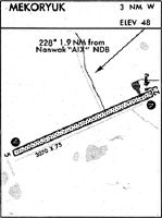
| 1.8 | AIX | . _ . . _ . . _ | Nanwak | NDB-DME | 323 | 64 | 56 |
| 68.6 | HPB | . . . . . _ _ . _ . . . | Hooper Bay | VOR-DME | 115.20 | 3 | 355 |
| 84.5 | CZF | _ . _ . _ _ . . . . _ . | Cape Romanzof | DME | 116.75 | 4 | 356 |
| 85.5 | CZF | _ . _ . _ _ . . . . _ . | Cape Romanzof | NDB | 275 | 5 | 357 |
Nearby Airports with Fuel
| Dist (NM) | Name (Airport IDs) | True Hdg | Mag Hdg | Fuel Grade |
|---|
Notices to Airmen (NOTAMS)
Remarks
| A110-1 | WILDLIFE ON RWY. |
| A110-2 | RWY COND UNMNT; RCMD VISUAL INSP PRIOR TO USE. |
| A110-4 | WX CAMERA AVBL ON INTERNET AT HTTPS://WEATHERCAMS.FAA.GOV |
| A33-06/24 | SHALLOW RUTS WITH PONDING AFT RAIN. |
| A42-06 | REFLECTIVE CONES & THR PANELS. |
| A42-24 | REFLECTIVE CONES & THR PANELS. |
| A57-06 | CTLG OBSTN EXCEEDS 45 DEG SLOPE. |
| A81-APT | ACTVT VASI RWY 06 & 24; MIRL RWY 06/24 - CTAF. |
| A83 | WINDSOCK UNRELIABLE. |
Runways
Runway Summary
| Runways: | 06/24 |
| Longest Runway: | 06/24 is 3001 ft (915 m) long |
| Runways with an Instrument Approach: |
MYU Airport Runway Details
| Runway 06/24 | 3001 ft x 75 ft (915 m x 23 m) | |
| Runway Length Source: | 3RD PARTY SURVEY as of 06/03/2014 | |
| Surface: | Gravel - Good condition - No special surface treatment | |
| Runway Edge Lights: | Medium Intensity | |
Runway 06 |
Runway 24 |
|
Elevation: |
53.3 | 52.4 |
Latitude: |
60-22-14.3952N | 60-22-26.8379N |
Longitude: |
166-16-39.8091W | 166-15-45.6745W |
|
Runway True Alignment: |
065 | 245 |
Glide Path Angle: |
3.0 degrees | 3.0 degrees |
Traffic Pattern: |
Left | Left |
Runway Markings Type: |
Nonstandard (other than numbers only) | Nonstandard (other than numbers only) |
Runway Markings Condition: |
Fair | Fair |
Object at End: |
ROAD | ROAD |
Object Height: |
15 | 15 |
Object Centerline Offset: |
65 ft. left of centerline | 65 ft. right of centerline |
Visual Glide Slope Indicators: |
4-Box VASI On Left Side Of Runway | 4-Box VASI On Right Side Of Runway |
REIL: |
No | No |
Threshold Crossing Height: |
28 | 29 |
Services
Landing Fees: |
No |
Maps & Diagrams
MYU Sectional
Flight Planning
at skyvector.com
at skyvector.com