Location
Latitude: |
45-37-13.6290N (45.620453) |
Longitude: |
122-39-23.3580W (-122.656488) |
Elevation: |
28.6 feet MSL (9 m MSL) |
Magnetic Variation: |
14.8 E (as of April 2024 from WMM2020 model) |
Time Zone: |
UTC -8.0 (Standard Time) UTC -7.0 (Daylight Savings Time) |
From City: |
02 N.M. SW of Vancouver, Washington |
Found On: |
Seattle Chart |
FAA Region: |
ANM |
Contacts
Manager: |
Publicly owned: |
| GUY LENNON PO BOX 1995 VANCOUVER, WA 98660 360-487-8619 |
CITY OF VANCOUVER PO BOX 1995 VANCOUVER, WA 98660 360-487-8619 |
Operations
Airport Status: |
Operational |
Facility Use: |
Public |
Type: |
Airport |
Activation Date: |
01/1939 |
Control tower: |
No |
Attendance (Months/Days/Hours): |
Months/Days/Hours NOV-MAR/ALL/0800-1700 |
Boundary ARTCC: |
ZSE (Seattle) |
Responsible ARTCC: |
ZSE (Seattle) |
Lighting Schedule: |
SEE RMK |
Segmented Circle Indicator: |
Yes |
Traffic Pattern Altitude (MSL): |
1029 feet (314 m) |
NOTAMs Facility: |
VUO |
NOTAM-D Service: |
Yes |
International Airport of Entry: |
No |
Customs Landing Rights: |
No |
Military Landing Rights: |
Yes |
Civil/Military Joint Use: |
No |
Based Aircraft
| Single Engine: | 131 |
| Multi Engine: | 5 |
| GA Helicopters: | 2 |
| Gliders: | 1 |
Annual Operations (as of 12/31/2022)
| Total Operations: | 52700 | |
| Air Taxi: | 100 | 0.2% |
| GA Local: | 18375 | 34.9% |
| GA Itinerant: | 34125 | 64.8% |
| Military Aircraft: | 100 | 0.2% |
Communications
| CTAF: | 119.000 |
| Approach: | PORTLAND 118.1 ;100-279, HIGH 118.1 ;100-279, HIGH 118.1 ;100-279, HIGH 118.1 ;100-279, HIGH 118.1 ;100-279, HIGH 118.1 ;100-279, HIGH |
| Departure: | PORTLAND 118.1 ;100-279, HIGH 118.1 ;100-279, HIGH 118.1 ;100-279, HIGH 118.1 ;100-279, HIGH 118.1 ;100-279, HIGH 118.1 ;100-279, HIGH |
| ASOS: | 135.125 (360-696-1280) |
- ARRIVALS CONTACT PEARSON ADVISORY ON 119.0 PRIOR TO ENTERING CLASS D AIRSPACE FOR TRAFFIC AND WAKE TURBULENCE ADVISORIES, DEPARTURES CONTACT PEARSON ADVISORY ON 119.0 PRIOR TO DEPARTURE.
- CLASS D VFR ADVSY SVC FREQ 119.0.
- COMMUNICATIONS PRVDD BY SEATTLE RADIO ON FREQ 122.35 (VANCOUVER RCO).
Fixed Based Operators (FBOs) & Fuel
(Click on a business for detail)
Please help us keep this information up to date. This is a FREE SERVICE just like everything else on Airport Guide! If you see that a business needs to be added, modified, or deleted please fill out our Update Form.
To add, modify, or delete a business click here.
Please help us keep this information up to date. This is a FREE SERVICE just like everything else on Airport Guide! If you see that a business needs to be added, modified, or deleted please fill out our Update Form.
Area Code: 360 |
| Business Name | Frequency | Phone | Fuel Grade |
|---|---|---|---|
| Aero Maintenance, Inc.
Update FBO info |
Unicom 123.0 | 735-9441 | 80, 100LL |
Flight Service Stations
| Primary | Alternate | |
| FSS on Field: | N | |
| FSS Name (ID): | Seattle(SEA) | |
| Frequency: | ||
| Toll Free Phone: | 1-800-WX-BRIEF |
Instrument Procedures / Charts
FAA Terminal Procedures valid from 0901Z 03/21/24 to 0901Z 04/18/24.
There are various types of charts available for an airport. They are listed in the Page Type column. Here is a legend for those types:
APD - Airport Diagram
DP - Departure Procedure Charts
HOT - Hot Spots
IAP - Instrument Approach Procedure Charts
MIN - Minimums
STAR - Standard Terminal Arrival Charts
| Page Type | Page Name | Volume | Action Since Last Cycle |
|---|---|---|---|
| IAP | RNAV (GPS)-B | NW-1 | |
| MIN | ALTERNATE MINIMUMS | NW-1 | |
| MIN | TAKEOFF MINIMUMS | NW-1 |
Terminal Procedures are only available for airports in several countries with more being added all the time. If you are looking for a specific country's charts, please send an email to support(at)airportguide.com stating the country name. This will be used to prioritize the implementation.
Navigation Aids (Navaids) near KVUO
| Dist (NM) | ID | Morse Code | Name | Type | Freq | True Hdg | Mag Hdg |
|---|---|---|---|---|---|---|---|
| 2.6 | PDX | . _ _ . _ . . _ . . _ | Portland | VOT | 111.00 | 122 | 107 |
| 2.6 | PDX | . _ _ . _ . . _ . . _ | Portland | VOR-DME | 111.80 | 127 | 112 |
| 2.7 | CBU | _ . _ . _ . . . . . _ | Columbia | TACAN | 109.20 | 135 | 120 |
| 8.1 | BTG | _ . . . _ _ _ . | Battle Ground | VORTAC | 116.60 | 19 | 4 |
| 9.4 | LBH | . _ . . _ . . . . . . . | Laker | NDB | 332 | 120 | 105 |
| 13.2 | HIO | . . . . . . _ _ _ | Hillsboro | VOT | 115.20 | 248 | 233 |
| 16.3 | PND | . _ _ . _ . _ . . | Banks | NDB | 356 | 272 | 257 |
| 21.0 | UBG | . . _ _ . . . _ _ . | Newberg | VOR-DME | 117.40 | 220 | 205 |
| 33.8 | LSO | . _ . . . . . _ _ _ | Kelso | NDB | 256 | 341 | 326 |
| 48.0 | SL | . . . . _ . . | Turno | NDB | 266 | 195 | 180 |
| 49.8 | PEN | . _ _ . . _ . | Karpen | NDB | 201 | 309 | 294 |
| 60.6 | AST | . _ . . . _ | Astoria | VOR-DME | 114.00 | 302 | 287 |
| 65.0 | AST | . _ . . . _ | Fort Stevens | FAN MARKER | 303 | 288 | |
| 65.5 | LTJ | . _ . . _ . _ _ _ | Klickitat | VOR-DME | 112.30 | 84 | 69 |
| 65.8 | LWG | . _ . . . _ _ _ _ . | Lewisburg | NDB | 225 | 203 | 188 |
| 72.5 | CVO | _ . _ . . . . _ _ _ _ | Corvallis | VOR-DME | 115.40 | 202 | 187 |
| 81.7 | OLM | _ _ _ . _ . . _ _ | Olympia | VORTAC | 113.40 | 352 | 337 |
| 83.4 | LAC | . _ . . . _ _ . _ . | Lacomas | NDB | 328 | 2 | 347 |
| 86.4 | ONP | _ _ _ _ . . _ _ . | Newport | VORTAC | 117.10 | 223 | 208 |
| 87.8 | EU | . . . _ | Frakk | NDB | 260 | 196 | 181 |
Nearby Airports with Fuel
Notices to Airmen (NOTAMS)
Remarks
| A10 | CITY OF VANCOUVER AND NPS. |
| A110*G | THIS AIRPORT HAS BEEN SURVEYED BY THE NATIONAL GEODETIC SURVEY. |
| A110-3 | WHEN OPERG OVER THE RY CNTRLN OR RY CNTRLN EXTDD - MAINTAIN AT OR BLO 700 FT MSL DUE TO TFC & WAKE TURBULENCE FROM OVERFLYING ACFT TO/FROM PORTLAND INTERNATIONAL ARPT (PDX) RY 10L/28R. PDX RY 10L/28R EXTDD CNTRLN CROSSES PEARSON RY 08 THLD. |
| A110-4 | GEESE ON AND INVOF ARPT. |
| A110-6 | AVOID OVERFLYING THE FORT VANCOUVER STOCKADE (NATIONAL PARK), LCT 360 FT NORTH OF THE WEST END OF RWY 8-26. |
| A110-7 | ARRIVALS CTC PEARSON ADZY ON 119.0 PRIOR TO ENTERING SPL FLT RULES AREA (SFRA) FOR TFC & WAKE TURB ADZYS, DEPS CTC PEARSON ADZY ON 119.0 PRIOR TO DEP. --MANDATORY VFR ADVZY SVC FREQ 119.0 --SPL FLT RULES AREA - FAR 93.163 --REFER TO CHART SUPPL SPL NOTICE FOR FULL PROC APCH AT 866-640-4124. |
| A16 | CELL 360-904-9007 |
| A31-08/26 | RWY 08/26 860 FT STOPWAY ON WEST END. |
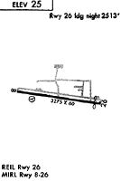
| A40-08/26 | RY 26 THR RELOCATED 762 FT FOR NIGHT OPERATIONS; 2513 FT OF RY 08/26 LGTD AT NIGHT. |
| A43-08 | VASI RWY 08 UNUSBL BYD 6 DEG L OR R OF RWY CNTRLN. |
| A57-26 | APCH SLOPE 44:1 AT DSPLCD THR. |
| A58-26 | +16 FT DIKE AT 115 FT, 6 FT FENCE AT 130 FT. |
| A70-FUEL-10 | 0LL SELF SERVICE FUEL AVBL 24 HRS BY CREDIT CARD. |
| A81-APT | ACTVT PAPI RWY 26; MIRL RWY 08/26 - CTAF. |
Runways
Runway Summary
| Runways: | 08/26 |
| Longest Runway: | 08/26 is 3275 ft (998 m) long |
| Runways with an Instrument Approach: |
KVUO Airport Runway Details
| Runway 08/26 | 3275 ft x 60 ft (998 m x 18 m) | |
| Runway Length Source: | NGS as of 02/02/1993 | |
| Surface: | Asphalt - Good condition - No special surface treatment | |
| Runway Edge Lights: | Medium Intensity | |
Runway 08 |
Runway 26 |
|
Elevation: |
28.6 | 22.2 |
Latitude: |
45-37-15.9340N | 45-37-11.3230N |
Longitude: |
122-39-46.1640W | 122-39-00.5520W |
|
Runway True Alignment: |
098 | 278 |
Glide Path Angle: |
3.8 degrees | 4.0 degrees |
Traffic Pattern: |
Left | Right |
Runway Markings Type: |
Basic | Basic |
Runway Markings Condition: |
Fair | Fair |
Object at End: |
BRDG | TREE |
Object Height: |
218 | 31 |
Distance from End: |
2647 | 280 |
Object Centerline Offset: |
482 ft. right of centerline | 0 ft. left and right of centerline |
Visual Glide Slope Indicators: |
4-Box VASI On Right Side Of Runway | 2-Light PAPI On Right Side Of Runway |
REIL: |
No | Yes |
Threshold Crossing Height: |
31 | 32 |
Threshold Elevation: |
23.3 | |
Displaced Threshold: |
762 | |
Threshold Latitude: |
45-37-12.3960N | |
Threshold Longitude: |
122-39-11.1590W | |
Declared Distances |
||
Take Off Run Avbl. (TORA): |
3275 | 3275 |
Take Off Distance Avbl. (TODA): |
3275 | 3275 |
Actual Stop Dist. Avbl. (ASDA): |
3065 | 3275 |
Landing Dist. Avbl. (LDA): |
3065 | 2513 |
Services
Airframe Repair: |
Minor |
Powerplant Repair: |
Minor |
Bottled Oxygen: |
None |
Bulk Oxygen: |
None |
Fuel Available: |
100LL |
Landing Fees: |
No |
Parking: |
Tiedowns available |
Maps & Diagrams
KVUO Sectional
Flight Planning
at skyvector.com
at skyvector.com