Location
Latitude: |
40-04-43.6000N (40.078778) |
Longitude: |
095-35-31.2000W (-95.592) |
Elevation: |
984.0 feet MSL (300 m MSL) |
Magnetic Variation: |
1.9 E (as of April 2024 from WMM2020 model) |
Time Zone: |
UTC -6.0 (Standard Time) UTC -5.0 (Daylight Savings Time) |
From City: |
01 N.M. NE of Falls City, Nebraska |
Found On: |
Omaha Chart |
FAA Region: |
ACE |
Contacts
Manager: |
Publicly owned: |
| BRAD AHERN 3301 BUSINESS PARKWAY NORTH FALLS CITY, NE 68355-1963 402-245-3715 |
FALLS CITY AIRPORT AUTHORITY 3301 BUSINESS PARKWAY FALLS CITY, NE 68355-1963 402-245-2748 |
Operations
Airport Status: |
Operational |
Facility Use: |
Public |
Type: |
Airport |
Activation Date: |
11/1946 |
Control tower: |
No |
Attendance (Months/Days/Hours): |
Months/Days/Hours ALL/ALL/0800-1700 |
Boundary ARTCC: |
ZKC (Kansas City) |
Responsible ARTCC: |
ZKC (Kansas City) |
Lighting Schedule: |
SEE RMK |
Segmented Circle Indicator: |
Yes |
Traffic Pattern Altitude (MSL): |
1984 feet (605 m) |
NOTAMs Facility: |
FNB |
NOTAM-D Service: |
Yes |
International Airport of Entry: |
No |
Customs Landing Rights: |
No |
Military Landing Rights: |
Yes |
Civil/Military Joint Use: |
No |
Based Aircraft
| Single Engine: | 18 |
| Ultralights: | 1 |
Annual Operations (as of 06/19/2023)
| Total Operations: | 8162 | |
| GA Local: | 6692 | 82.0% |
| GA Itinerant: | 1450 | 17.8% |
| Military Aircraft: | 20 | 0.2% |
Communications
| CTAF: | 122.800 |
| Unicom: | 122.800 |
| Approach: | ST JOSEPH 120.35 120.35 KANSAS CITY ARTCC |
| Departure: | ST JOSEPH 120.35 120.35 KANSAS CITY ARTCC |
| ASOS: | 119.275 (402-245-5948) |
- APCH/DEP SVC PRVDD BY KANSAS CITY ARTCC (ZKC) ON FREQ 127.9/251.1 (SAINT JOSEPH RCAG) WHEN ST JOSEPH APCH CTL CLSD.
Fixed Based Operators (FBOs) & Fuel
(Click on a business for detail)
Please help us keep this information up to date. This is a FREE SERVICE just like everything else on Airport Guide! If you see that a business needs to be added, modified, or deleted please fill out our Update Form.
To add, modify, or delete a business click here.
Please help us keep this information up to date. This is a FREE SERVICE just like everything else on Airport Guide! If you see that a business needs to be added, modified, or deleted please fill out our Update Form.
Area Code: 402 |
| Business Name | Frequency | Phone | Fuel Grade |
|---|---|---|---|
| Falls City Aero Service
Update FBO info |
Unicom 122.8 | 245-3715 | 100LL, Jet A |
Flight Service Stations
| Primary | Alternate | |
| FSS on Field: | N | |
| FSS Name (ID): | Columbus(OLU) | |
| Frequency: | ||
| Toll Free Phone: | 1-800-WX-BRIEF |
Instrument Procedures / Charts
FAA Terminal Procedures valid from 0901Z 03/21/24 to 0901Z 04/18/24.
There are various types of charts available for an airport. They are listed in the Page Type column. Here is a legend for those types:
APD - Airport Diagram
DP - Departure Procedure Charts
HOT - Hot Spots
IAP - Instrument Approach Procedure Charts
MIN - Minimums
STAR - Standard Terminal Arrival Charts
| Page Type | Page Name | Volume | Action Since Last Cycle |
|---|---|---|---|
| IAP | RNAV (GPS) RWY 15 | NC-2 | |
| IAP | RNAV (GPS) RWY 33 | NC-2 | |
| MIN | TAKEOFF MINIMUMS | NC-2 |
Terminal Procedures are only available for airports in several countries with more being added all the time. If you are looking for a specific country's charts, please send an email to support(at)airportguide.com stating the country name. This will be used to prioritize the implementation.
Navigation Aids (Navaids) near KFNB
| Dist (NM) | ID | Morse Code | Name | Type | Freq | True Hdg | Mag Hdg |
|---|---|---|---|---|---|---|---|
| 0.3 | FNB | . . _ . _ . _ . . . | Brenner | NDB | 404 | 122 | 120 |
| 15.7 | RBA | . _ . _ . . . . _ | Robinson | DME | 108.2 | 150 | 148 |
| 29.1 | PWE | . _ _ . . _ _ . | Pawnee City | DME | 112.4 | 284 | 282 |
| 31.4 | STJ | . . . _ . _ _ _ | St Joseph | VORTAC | 115.50 | 102 | 100 |
| 33.5 | AZN | . _ _ _ . . _ . | Amazon | NDB | 233 | 110 | 108 |
| 33.9 | AFK | . _ . . _ . _ . _ | Nebraska City | NDB | 347 | 338 | 336 |
| 39.7 | ST | . . . _ | Tario | NDB | 260 | 127 | 125 |
| 41.2 | SDA | . . . _ . . . _ | Shenandoah | NDB | 411 | 11 | 9 |
| 46.5 | ICL | . . _ . _ . . _ . . | Clarinda | NDB | 353 | 33 | 31 |
| 53.9 | PMV | . _ _ . _ _ . . . _ | Plattsmouth | NDB | 329 | 344 | 342 |
| 54.9 | BIE | _ . . . . . . | Beatrice | VOR | 110.60 | 284 | 282 |
| 56.5 | TOP | _ _ _ _ . _ _ . | Topeka | VORTAC | 117.80 | 177 | 175 |
| 57.7 | TO | _ _ _ _ | Biloy | NDB | 521 | 184 | 182 |
| 58.2 | RDK | . _ . _ . . _ . _ | Red Oak | NDB | 230 | 15 | 13 |
| 61.8 | MCI | _ _ _ . _ . . . | Kansas City | VORTAC | 113.25 | 140 | 138 |
| 63.9 | OFF | _ _ _ . . _ . . . _ . | Offutt | TACAN | 111.70 | 347 | 345 |
| 64.5 | DO | _ . . _ _ _ | Dotte | NDB | 359 | 142 | 140 |
| 65.6 | OVR | _ _ _ . . . _ . _ . | Omaha | VORTAC | 116.30 | 354 | 352 |
| 66.8 | LN | . _ . . _ . | Potts | NDB | 385 | 307 | 305 |
| 66.9 | CRZ | _ . _ . . _ . _ _ . . | Corning | NDB | 278 | 34 | 32 |
Nearby Airports with Fuel
Notices to Airmen (NOTAMS)
Remarks
| A110*G | THIS AIRPORT HAS BEEN SURVEYED BY THE NATIONAL GEODETIC SURVEY. |
| A110-1 | FOR CD CTC ST JOSEPH APCH AT 816-236-3035. WHEN ST JOSEPH APCH IS CLSD, CTC KANSAS CITY ARTCC AT 913-254-8508. |
| A17 | FOR SVC AFT HRS CALL 402-245-3715 OR 402-245-7313. |
| A57-15 | RWY 15 CLNC SLOPE 39:1 DUE TO TREES 876 FT OUT & 17 FT ABV RWY END, 193 FT RIGHT. |
| A70-FUEL-10 | 0LL 24 HR CREDIT CARD FUELING |
| A75 | CALL ARPT MGR TO ARNG TRANSIENT HANGAR RENTAL 402-245-3715. |
| A81-APT | ACTVT MIRL RY 15/33; PAPI RY 15/33 AND REIL RY 15 & 33 - CTAF. |
| A96 | ULTRALIGHT ACTIVITY ON & INVOF ARPT. |
Runways
Runway Summary
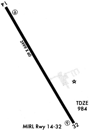
| Runways: | 15/33 |
| Longest Runway: | 15/33 is 3999 ft (1219 m) long |
| Runways with an Instrument Approach: |
KFNB Airport Runway Details
| Runway 15/33 | 3999 ft x 75 ft (1219 m x 23 m) | |
| Runway Length Source: | FAA as of 12/11/2014 | |
| Surface: | Concrete - Good condition - No special surface treatment | |
| Runway Edge Lights: | Medium Intensity | |
Runway Weight Bearing Capacity (in thousands of pounds) |
||
| Single Wheel Landing Gear: | 30.0 | |
| Dual Wheel Landing Gear: | 48.0 | |
Runway 15 |
Runway 33 |
|
Elevation: |
983.7 | 979.6 |
Latitude: |
40-05-00.5343N | 40-04-26.7089N |
Longitude: |
095-35-44.4662W | 095-35-17.8577W |
|
Runway True Alignment: |
149 | 329 |
Glide Path Angle: |
3.0 degrees | 3.0 degrees |
Traffic Pattern: |
Left | Left |
Runway Markings Type: |
Nonprecision Instrument | Nonprecision Instrument |
Runway Markings Condition: |
Good | Good |
Visual Glide Slope Indicators: |
2-Light PAPI On Left Side Of Runway | 2-Light PAPI On Left Side Of Runway |
REIL: |
Yes | Yes |
Threshold Crossing Height: |
40 | 40 |
Services
Airframe Repair: |
None |
Powerplant Repair: |
None |
Bottled Oxygen: |
None |
Bulk Oxygen: |
None |
Fuel Available: |
100LL |
Landing Fees: |
No |
Parking: |
Tiedowns available |
Maps & Diagrams
KFNB Sectional
Flight Planning
at skyvector.com
at skyvector.com