Location
Latitude: |
39-30-57.6000N (39.516) |
Longitude: |
082-58-55.7000W (-82.982139) |
Elevation: |
684.8 feet MSL (209 m MSL) |
Magnetic Variation: |
7.2 W (as of April 2024 from WMM2020 model) |
Time Zone: |
UTC -5.0 (Standard Time) UTC -4.0 (Daylight Savings Time) |
From City: |
05 N.M. S of Circleville, Ohio |
Found On: |
Cincinnati Chart |
FAA Region: |
AGL |
Contacts
Manager: |
Publicly owned: |
| PICKAWAY CO AIRPORT AUTHORITY 28181 MCCRADY RD CIRCLEVILLE, OH 43113-9725 740-474-5145 |
PICKAWAY CO AIRPORT AUTHORITY 28181 MCCRADY RD CIRCLEVILLE, OH 43113-9725 740-474-5145 |
Operations
Airport Status: |
Operational |
Facility Use: |
Public |
Type: |
Airport |
Control tower: |
No |
Attendance (Months/Days/Hours): |
Months/Days/Hours Unattended |
Boundary ARTCC: |
ZID (Indianapolis) |
Responsible ARTCC: |
ZID (Indianapolis) |
Lighting Schedule: |
SEE RMK |
Segmented Circle Indicator: |
No |
Traffic Pattern Altitude (MSL): |
1685 feet (514 m) |
NOTAMs Facility: |
DAY |
NOTAM-D Service: |
Yes |
Civil/Military Joint Use: |
No |
Based Aircraft
| Single Engine: | 26 |
Annual Operations (as of 07/21/2021)
| Total Operations: | 35950 | |
| GA Local: | 26250 | 73.0% |
| GA Itinerant: | 8200 | 22.8% |
| Military Aircraft: | 1500 | 4.2% |
Communications
| CTAF: | 122.700 |
| Unicom: | 122.700 |
| Approach: | COLUMBUS 132.3 ;100-279 132.3 ;100-279 132.3 ;100-279 132.3 ;100-279 |
| Departure: | COLUMBUS 132.3 ;100-279 132.3 ;100-279 132.3 ;100-279 132.3 ;100-279 |
Fixed Based Operators (FBOs) & Fuel
(Click on a business for detail)
Please help us keep this information up to date. This is a FREE SERVICE just like everything else on Airport Guide! If you see that a business needs to be added, modified, or deleted please fill out our Update Form.
To add, modify, or delete a business click here.
Please help us keep this information up to date. This is a FREE SERVICE just like everything else on Airport Guide! If you see that a business needs to be added, modified, or deleted please fill out our Update Form.
Area Code: 740 |
| Business Name | Frequency | Phone | Fuel Grade |
|---|---|---|---|
| Buckeye Aerial Services
Update FBO info |
Unicom 122.7 | 800-257-6209, 474-5145 | 80, 100LL, Jet A |
Flight Service Stations
| Primary | Alternate | |
| FSS on Field: | N | |
| FSS Name (ID): | Dayton(DAY) | |
| Frequency: | ||
| Toll Free Phone: | 1-800-WX-BRIEF |
Instrument Procedures / Charts
FAA Terminal Procedures valid from 0901Z 03/21/24 to 0901Z 04/18/24.
There are various types of charts available for an airport. They are listed in the Page Type column. Here is a legend for those types:
APD - Airport Diagram
DP - Departure Procedure Charts
HOT - Hot Spots
IAP - Instrument Approach Procedure Charts
MIN - Minimums
STAR - Standard Terminal Arrival Charts
| Page Type | Page Name | Volume | Action Since Last Cycle |
|---|---|---|---|
| IAP | RNAV (GPS) RWY 01 | EC-2 | |
| IAP | RNAV (GPS) RWY 19 | EC-2 | |
| IAP | VOR RWY 19 | EC-2 | |
| MIN | ALTERNATE MINIMUMS | EC-2 | |
| MIN | TAKEOFF MINIMUMS | EC-2 |
Terminal Procedures are only available for airports in several countries with more being added all the time. If you are looking for a specific country's charts, please send an email to support(at)airportguide.com stating the country name. This will be used to prioritize the implementation.
Navigation Aids (Navaids) near KCYO
| Dist (NM) | ID | Morse Code | Name | Type | Freq | True Hdg | Mag Hdg |
|---|---|---|---|---|---|---|---|
| 0.7 | XUB | _ . . _ . . _ _ . . . | Yellow Bud | VOR | 112.50 | 16 | 23 |
| 5.1 | RZT | . _ . _ _ . . _ | Ross County | NDB | 236 | 204 | 211 |
| 13.7 | DD | _ . . _ . . | Cobbs | NDB | 253 | 352 | 359 |
| 17.7 | LCK | . _ . . _ . _ . _ . _ | Rickenbacker | TACAN | 69X | 7 | 14 |
| 19.6 | CSS | _ . _ . . . . . . . | Court House | NDB | 414 | 285 | 292 |
| 20.9 | BU | _ . . . . . _ | Boutn | NDB | 230 | 330 | 337 |
| 21.1 | EOP | . _ _ _ . _ _ . | Waverly | NDB | 385 | 173 | 180 |
| 22.9 | LC | . _ . . _ . _ . | Pickl | NDB | 376 | 17 | 24 |
| 29.1 | CMH | _ . _ . _ _ . . . . | Port Columbus | VOT | 111.00 | 8 | 15 |
| 29.7 | CHC | _ . _ . . . . . _ . _ . | Grens | NDB | 272 | 355 | 362 |
| 30.1 | CM | _ . _ . _ _ | Sumie | NDB | 391 | 20 | 27 |
| 32.7 | HOC | . . . . _ _ _ _ . _ . | Hillsboro | NDB | 278 | 232 | 239 |
| 34.9 | OS | _ _ _ . . . | Fuler | NDB | 515 | 343 | 350 |
| 35.0 | IL | . . . _ . . | Airbo | NDB | 407 | 267 | 274 |
| 38.3 | MXQ | _ _ _ . . _ _ _ . _ | Midwest | VOR-DME | 112.90 | 262 | 269 |
| 38.8 | HEH | . . . . . . . . . | Newark | NDB | 524 | 37 | 44 |
| 39.1 | PZO | . _ _ . _ _ . . _ _ _ | Peebles | NDB | 329 | 204 | 211 |
| 40.4 | UNI | . . _ _ . . . | Athens | FAN MARKER | 115 | 122 | |
| 42.2 | APE | . _ . _ _ . . | Appleton | VORTAC | 116.70 | 25 | 32 |
| 42.5 | HW | . . . . . _ _ | Cubla | NDB | 299 | 257 | 264 |
Nearby Airports with Fuel
Notices to Airmen (NOTAMS)
Remarks
| A110-1 | FOR CD CTC COLUMBUS APCH AT 614-338-8537. |
| A70-FUEL-10 | 0LL 100LL & JET A AVBL H24 VIA CREDIT CARD. |
| A81-APT | ACTVT REIL RWY 19; PAPI RWY 19; MIRL RWY 01/19 - CTAF. |
Runways
Runway Summary
| Runways: | 01/19 |
| Longest Runway: | 01/19 is 4346 ft (1325 m) long |
| Runways with an Instrument Approach: |
KCYO Airport Runway Details
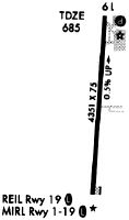
| Runway 01/19 | 4346 ft x 75 ft (1325 m x 23 m) | |
| Runway Length Source: | 3RD PARTY SURVEY as of 09/15/2010 | |
| Surface: | Asphalt - Good condition - No special surface treatment | |
| Runway Edge Lights: | Medium Intensity | |
Runway Weight Bearing Capacity (in thousands of pounds) |
||
| Single Wheel Landing Gear: | 30.0 | |
| Dual Wheel Landing Gear: | 40.0 | |
Runway 01 |
Runway 19 |
|
Elevation: |
663.7 | 684.8 |
Latitude: |
39-30-36.1878N | 39-31-19.0782N |
Longitude: |
082-58-57.2208W | 082-58-54.1988W |
|
Runway True Alignment: |
003 | 183 |
Glide Path Angle: |
0.0 degrees | 3.0 degrees |
Traffic Pattern: |
Left | Left |
Runway Markings Type: |
Nonprecision Instrument | Nonprecision Instrument |
Runway Markings Condition: |
Good | Good |
Object at End: |
TREES | |
Object Height: |
56 | |
Distance from End: |
989 | |
Object Centerline Offset: |
316 ft. right of centerline | |
Visual Glide Slope Indicators: |
4-Light PAPI On Right Side Of Runway | |
REIL: |
Yes | |
Touchdown Lights: |
No | No |
Centerline Lights: |
No | No |
Threshold Crossing Height: |
24 |
Services
Airframe Repair: |
Major |
Powerplant Repair: |
Major |
Fuel Available: |
100LL |
Landing Fees: |
No |
Parking: |
Hangars and tiedowns available |
Maps & Diagrams
KCYO Sectional
Flight Planning
at skyvector.com
at skyvector.com