Location
Latitude: |
39-45-45.4000N (39.762611) |
Longitude: |
098-47-40.2000W (-98.7945) |
Elevation: |
1799.5 feet MSL (548 m MSL) |
Magnetic Variation: |
4 E (as of April 2024 from WMM2020 model) |
Time Zone: |
UTC -6.0 (Standard Time) UTC -5.0 (Daylight Savings Time) |
From City: |
01 N.M. SW of Smith Center, Kansas |
Found On: |
Wichita Chart |
FAA Region: |
ACE |
Contacts
Manager: |
Publicly owned: |
| CITY OF SMITH CENTER 119 WEST COURT SMITH CENTER, KS 66967 785-282-3812 |
CITY OF SMITH CENTER SMITH CENTER SMITH CENTER, KS 66967 |
Operations
Airport Status: |
Operational |
Facility Use: |
Public |
Type: |
Airport |
Activation Date: |
12/1944 |
Control tower: |
No |
Attendance (Months/Days/Hours): |
Months/Days/Hours ON CALL |
Boundary ARTCC: |
ZMP (Minneapolis) |
Responsible ARTCC: |
ZMP (Minneapolis) |
Lighting Schedule: |
SEE RMK |
Segmented Circle Indicator: |
No |
Traffic Pattern Altitude (MSL): |
2800 feet (853 m) |
NOTAMs Facility: |
ICT |
NOTAM-D Service: |
Yes |
Civil/Military Joint Use: |
No |
Based Aircraft
| Single Engine: | 9 |
| Multi Engine: | 1 |
Annual Operations (as of 09/11/2018)
| Total Operations: | 4012 | |
| GA Local: | 2500 | 62.3% |
| GA Itinerant: | 1500 | 37.4% |
| Military Aircraft: | 12 | 0.3% |
Communications
| CTAF: | 122.800 |
| Unicom: | 122.800 |
| AWOS-3PT: | 118.450 (785-282-8326) |
- APCH/DEP SVC PRVDD BY MINNEAPOLIS ARTCC ON FREQS 119.4/278.8 (HASTINGS RCAG).
Fixed Based Operators (FBOs) & Fuel
(Click on a business for detail)
Please help us keep this information up to date. This is a FREE SERVICE just like everything else on Airport Guide! If you see that a business needs to be added, modified, or deleted please fill out our Update Form.
To add, modify, or delete a business click here.
Please help us keep this information up to date. This is a FREE SERVICE just like everything else on Airport Guide! If you see that a business needs to be added, modified, or deleted please fill out our Update Form.
Area Code: 785 |
| Business Name | Frequency | Phone | Fuel Grade |
|---|
Flight Service Stations
| Primary | Alternate | |
| FSS on Field: | N | |
| FSS Name (ID): | Wichita(ICT) | |
| Frequency: | ||
| Toll Free Phone: | 1-800-WX-BRIEF |
Instrument Procedures / Charts
FAA Terminal Procedures valid from 0901Z 03/21/24 to 0901Z 04/18/24.
There are various types of charts available for an airport. They are listed in the Page Type column. Here is a legend for those types:
APD - Airport Diagram
DP - Departure Procedure Charts
HOT - Hot Spots
IAP - Instrument Approach Procedure Charts
MIN - Minimums
STAR - Standard Terminal Arrival Charts
| Page Type | Page Name | Volume | Action Since Last Cycle |
|---|---|---|---|
| IAP | RNAV (GPS) RWY 14 | NC-2 | |
| IAP | RNAV (GPS) RWY 18 | NC-2 | |
| IAP | RNAV (GPS) RWY 32 | NC-2 | |
| IAP | RNAV (GPS) RWY 36 | NC-2 | |
| IAP | VOR-A | NC-2 |
Terminal Procedures are only available for airports in several countries with more being added all the time. If you are looking for a specific country's charts, please send an email to support(at)airportguide.com stating the country name. This will be used to prioritize the implementation.
Navigation Aids (Navaids) near K82
| Dist (NM) | ID | Morse Code | Name | Type | Freq | True Hdg | Mag Hdg |
|---|---|---|---|---|---|---|---|
| 23.0 | PHG | . _ _ . . . . . _ _ . | Phillipsburg | NDB | 368 | 261 | 257 |
| 24.8 | TKO | _ _ . _ _ _ _ | Mankato | VORTAC | 109.80 | 83 | 79 |
| 50.8 | NRN | _ . . _ . _ . | Norton | NDB | 230 | 276 | 272 |
| 52.5 | RPB | . _ . . _ _ . _ . . . | Republican | NDB | 414 | 86 | 82 |
| 52.9 | EA | . . _ | Anoke | NDB | 422 | 348 | 344 |
| 53.2 | HSI | . . . . . . . . . | Hastings | VOR-DME | 108.80 | 18 | 14 |
| 54.3 | CNK | _ . _ . _ . _ . _ | Concordia | NDB | 335 | 103 | 99 |
| 57.3 | PSS | . _ _ . . . . . . . | Prosser | NDB | 338 | 14 | 10 |
| 58.6 | EAR | . . _ . _ . | Kearney | VOR | 111.20 | 350 | 346 |
| 59.3 | HYS | . . . . _ . _ _ . . . | Hays | VORTAC | 110.40 | 202 | 198 |
| 60.2 | HJH | . . . . . _ _ _ . . . . | Hebron | NDB | 323 | 66 | 62 |
| 63.3 | HY | . . . . _ . _ _ | Nette | NDB | 374 | 199 | 195 |
| 70.1 | GR | _ _ . . _ . | Sancy | NDB | 380 | 18 | 14 |
| 70.6 | CSB | _ . _ . . . . _ . . . | Harry Strunk | NDB | 389 | 297 | 293 |
| 72.8 | HLC | . . . . . _ . . _ . _ . | Hill City | VORTAC | 113.70 | 245 | 241 |
| 74.1 | SLN | . . . . _ . . _ . | Salina | VORTAC | 117.10 | 132 | 128 |
| 75.0 | FMZ | . . _ . _ _ _ _ . . | Beklof | NDB | 392 | 48 | 44 |
| 76.5 | GRI | _ _ . . _ . . . | Grand Island | VOR-DME | 112.00 | 16 | 12 |
| 78.9 | FBY | . . _ . _ . . . _ . _ _ | Fairbury | NDB | 293 | 71 | 68 |
| 78.9 | CYW | _ . _ . _ . _ _ . _ _ | Clay Center | NDB | 362 | 106 | 103 |
Nearby Airports with Fuel
Notices to Airmen (NOTAMS)
Remarks
| A110-1 | PUBLIC PHONE AVBL 24 HRS. |
| A110-2 | FOR CD CTC MINNEAPOLIS ARTCC AT 651-463-5588. |
| A17 | FOR ARPT ATTENDANT CALL 785-282-6588 OR 785-282-5837. |
| A42-18 | RWY 18 NO MKGS FOR NPI RWY. |
| A42-36 | RWY 36 NO MKGS FOR NPI RWY. |
| A54-14 | CROPS VARY IN HEIGHT 0-6 FT. |
| A57-36 | APCH SLOPE 21:1 FROM DSPLCD THLD. |
| A70-FUEL-10 | 0LL FOR FUEL CALL 785-282-6555. |
| A81-APT | ACTVT MIRL RWY 14/32, REIL RWY 14 AND 32, PAPI RWY 14 AND 32 - CTAF. |
| E111 | PRVDD THE APCH TO EACH RWY IS MAINTD FOR A MIN 20:1 GLIDE SLOPE AND THE TRSNL SFC BE MAINTD FOR A 7:1 SLOPE. |
Runways
Runway Summary
| Runways: | 14/32 18/36 |
| Longest Runway: | 14/32 is 4400 ft (1341 m) long |
| Runways with an Instrument Approach: |
K82 Airport Runway Details
| Runway 14/32 | 4400 ft x 75 ft (1341 m x 23 m) | |
| Runway Length Source: | 3RD PARTY SURVEY as of 06/02/2010 | |
| Surface: | Concrete - Good condition - No special surface treatment | |
| Runway Pavement Class: | 11 /R/C/X/U | |
| Runway Edge Lights: | Medium Intensity | |
Runway Weight Bearing Capacity (in thousands of pounds) |
||
| Single Wheel Landing Gear: | 30.0 | |
| Dual Wheel Landing Gear: | 30.0 | |
Runway 14 |
Runway 32 |
|
Elevation: |
1785.7 | 1799.5 |
Latitude: |
39-46-06.9060N | 39-45-29.1183N |
Longitude: |
098-47-55.9074W | 098-47-28.0401W |
|
Runway True Alignment: |
151 | 331 |
Glide Path Angle: |
3.0 degrees | 3.0 degrees |
Traffic Pattern: |
Left | Left |
Runway Markings Type: |
Nonprecision Instrument | Nonprecision Instrument |
Runway Markings Condition: |
Good | Good |
Visual Glide Slope Indicators: |
4-Light PAPI On Left Side Of Runway | 4-Light PAPI On Left Side Of Runway |
REIL: |
Yes | Yes |
Threshold Crossing Height: |
40 | 40 |
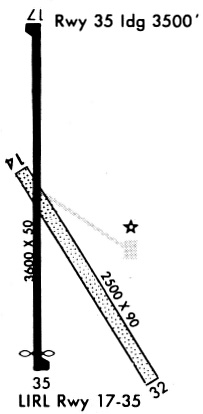
| Runway 18/36 | 3601 ft x 50 ft (1098 m x 15 m) | |
| Runway Length Source: | 3RD PARTY SURVEY as of 06/02/2010 | |
| Surface: | Concrete - Good condition - No special surface treatment | |
| Runway Pavement Class: | 5 /F/C/Y/U | |
Runway Weight Bearing Capacity (in thousands of pounds) |
||
| Single Wheel Landing Gear: | 4.0 | |
Runway 18 |
Runway 36 |
|
Elevation: |
1796.5 | 1787.2 |
Latitude: |
39-45-59.8998N | 39-45-24.3192N |
Longitude: |
098-47-37.7767W | 098-47-38.0450W |
|
Runway True Alignment: |
180 | 000 |
Glide Path Angle: |
0.0 degrees | 0.0 degrees |
Traffic Pattern: |
Left | Left |
Runway Markings Type: |
Nonprecision Instrument | Nonprecision Instrument |
Runway Markings Condition: |
Good | Good |
Object at End: |
ROAD | |
Object Height: |
15 | |
Distance from End: |
225 | |
Threshold Elevation: |
1788.0 | |
Displaced Threshold: |
101 | |
Threshold Latitude: |
39-45-25.3133N | |
Threshold Longitude: |
098-47-38.0372W | |
Declared Distances |
||
Take Off Run Avbl. (TORA): |
3601 | 3601 |
Take Off Distance Avbl. (TODA): |
3601 | 3601 |
Actual Stop Dist. Avbl. (ASDA): |
3500 | 3601 |
Landing Dist. Avbl. (LDA): |
3601 | 3500 |
Services
Airframe Repair: |
Major |
Powerplant Repair: |
Major |
Bottled Oxygen: |
None |
Bulk Oxygen: |
None |
Fuel Available: |
100LL |
Landing Fees: |
No |
Parking: |
Hangars and tiedowns available |
Maps & Diagrams
K82 Sectional
Flight Planning
at skyvector.com
at skyvector.com