Location
Latitude: |
32-18-40.2000N (32.311167) |
Longitude: |
090-04-33.2000W (-90.075889) |
Elevation: |
346.4 feet MSL (106 m MSL) |
Magnetic Variation: |
1.6 W (as of April 2024 from WMM2020 model) |
Time Zone: |
UTC -6.0 (Standard Time) UTC -5.0 (Daylight Savings Time) |
From City: |
05 N.M. E of Jackson, Mississippi |
Found On: |
Memphis Chart |
FAA Region: |
ASO |
Contacts
Manager: |
Publicly owned: |
| AUSTIN JENKINS 100 INTERNATIONAL DRIVE, SUITE 300 JACKSON, MS 39208-8109 601-939-5631 |
CITY OF JACKSON P.O. BOX 98109 JACKSON, MS 39298-8109 601-939-5631 |
Operations
Airport Status: |
Operational |
Facility Use: |
Public |
Type: |
Airport |
Activation Date: |
07/1963 |
Control tower: |
Yes |
Attendance (Months/Days/Hours): |
Months/Days/Hours ALL/ALL/ALL |
Boundary ARTCC: |
ZME (Memphis) |
Responsible ARTCC: |
ZME (Memphis) |
Lighting Schedule: |
SEE RMK |
Segmented Circle Indicator: |
Yes |
Traffic Pattern Altitude (MSL): |
1346 feet (410 m) |
NOTAMs Facility: |
JAN |
NOTAM-D Service: |
Yes |
International Airport of Entry: |
No |
Customs Landing Rights: |
Yes |
Military Landing Rights: |
Yes |
Civil/Military Joint Use: |
No |
Aircraft Rescue and Firefighting: |
Class I ARFF Index: C Air Carrier Service: Scheduled Certification Date: 05/1973 |
Based Aircraft
| Single Engine: | 6 |
| Multi Engine: | 11 |
| Jet Engine: | 9 |
| Military Aircraft: | 9 |
Annual Operations (as of 10/31/2022)
| Total Operations: | 48918 | |
| Commercial: | 14704 | 30.1% |
| Air Taxi: | 7393 | 15.1% |
| GA Local: | 1093 | 2.2% |
| GA Itinerant: | 7472 | 15.3% |
| Military Aircraft: | 18256 | 37.3% |
Communications
| CTAF: | 120.900 |
| Unicom: | 122.950 |
| Tower: | JACKSON 120.9 352.0 Hrs: 1200-0500Z++ |
| Ground: | 121.7 348.6 |
| Approach: | JACKSON 123.9 ;333-152 125.25 ;153-332 317.7 ;333-152 319.2 ;153-332 Hrs: 1200-0500Z++ MEMPHIS ARTCC Hrs: 0500-1200Z++ |
| Departure: | JACKSON 123.9 ;333-152 125.25 ;153-332 317.7 ;333-152 319.2 ;153-332 Hrs: 1200-0500Z++ MEMPHIS ARTCC Hrs: 0500-1200Z++ |
| ATIS: | 121.05 Hrs: 24 |
| ASOS: | 121.05 (601-932-2822) |
| ANG COMD POST: | 264.6 |
| EMERG: | 121.5 |
| CLASS C: | 317.7 ;333-152 |
| CLASS C: | 319.2 ;153-332 |
| CLASS C: | 123.9 ;333-152 |
| CLASS C: | 125.25 ;153-332 |
| EMERG: | 243.0 |
- APCH/DEP SVC PRVDD BY MEMPHIS ARTCC ON FREQS 132.5/259.1 (JACKSON RCAG) WHEN JACKSON APCH CTL CLSD.
- 172ND AW CP.
Fixed Based Operators (FBOs) & Fuel
(Click on a business for detail)
Please help us keep this information up to date. This is a FREE SERVICE just like everything else on Airport Guide! If you see that a business needs to be added, modified, or deleted please fill out our Update Form.
To add, modify, or delete a business click here.
Please help us keep this information up to date. This is a FREE SERVICE just like everything else on Airport Guide! If you see that a business needs to be added, modified, or deleted please fill out our Update Form.
Area Code: 601 |
| Business Name | Frequency | Phone | Fuel Grade |
|---|---|---|---|
| Jackson Air Center, Inc.
Update FBO info |
Unicom 122.95 | 939-9366 | 100LL, Jet A |
Flight Service Stations
| Primary | Alternate | |
| FSS on Field: | N | |
| FSS Name (ID): | Greenwood(GWO) | |
| Frequency: | ||
| Toll Free Phone: | 1-800-WX-BRIEF |
Instrument Procedures / Charts
FAA Terminal Procedures valid from 0901Z 03/21/24 to 0901Z 04/18/24.
There are various types of charts available for an airport. They are listed in the Page Type column. Here is a legend for those types:
APD - Airport Diagram
DP - Departure Procedure Charts
HOT - Hot Spots
IAP - Instrument Approach Procedure Charts
MIN - Minimums
STAR - Standard Terminal Arrival Charts
| Page Type | Page Name | Volume | Action Since Last Cycle |
|---|---|---|---|
| APD | AIRPORT DIAGRAM | SC-4 | |
| IAP | ILS OR LOC RWY 16L | SC-4 | |
| IAP | ILS OR LOC RWY 34L | SC-4 | |
| IAP | ILS RWY 16L (CAT II - III) | SC-4 | |
| IAP | ILS RWY 16L (SA CAT I) | SC-4 | |
| IAP | RNAV (GPS) RWY 16L | SC-4 | |
| IAP | RNAV (GPS) RWY 16R | SC-4 | |
| IAP | RNAV (GPS) RWY 34L | SC-4 | |
| IAP | RNAV (GPS) RWY 34R | SC-4 | |
| IAP | VOR/DME OR TACAN RWY 16L | SC-4 | |
| IAP | VOR/DME OR TACAN RWY 16R | SC-4 | |
| IAP | VOR/DME OR TACAN RWY 34L | SC-4 | |
| IAP | VOR/DME OR TACAN RWY 34R | SC-4 | |
| MIN | ALTERNATE MINIMUMS | SC-4 | |
| MIN | RADAR MINIMUMS | SC-4 | |
| MIN | TAKEOFF MINIMUMS | SC-4 |
Terminal Procedures are only available for airports in several countries with more being added all the time. If you are looking for a specific country's charts, please send an email to support(at)airportguide.com stating the country name. This will be used to prioritize the implementation.
Navigation Aids (Navaids) near JAN
| Dist (NM) | ID | Morse Code | Name | Type | Freq | True Hdg | Mag Hdg |
|---|---|---|---|---|---|---|---|
| 0.5 | JAN | . _ _ _ . _ _ . | Jackson | VOT | 111.00 | 94 | 96 |
| 6.5 | JA | . _ _ _ . _ | Allen | NDB | 365 | 340 | 342 |
| 7.5 | MHZ | _ _ . . . . _ _ . . | Magnolia | VORTAC | 113.20 | 350 | 352 |
| 11.2 | JH | . _ _ _ . . . . | Brenz | NDB | 260 | 303 | 305 |
| 12.7 | JAN | . _ _ _ . _ _ . | Jackson | VORTAC | 112.60 | 338 | 340 |
| 17.0 | RYB | . _ . _ . _ _ _ . . . | Raymond | NDB | 375 | 268 | 270 |
| 48.3 | TKH | _ _ . _ . . . . | Tallulah | NDB | 344 | 265 | 266 |
| 58.6 | THJ | _ . . . . . _ _ _ | Tallahala | NDB | 346 | 129 | 131 |
| 61.1 | MCB | _ _ _ . _ . _ . . . | Mc Comb | VORTAC | 116.70 | 188 | 190 |
| 64.4 | BLE | _ . . . . _ . . . | Lake Providence | NDB | 278 | 299 | 300 |
| 64.6 | MEI | _ _ . . . | Meridian | VORTAC | 117.00 | 86 | 88 |
| 65.4 | LBY | . _ . . _ . . . _ . _ _ | Eaton | VORTAC | 110.60 | 144 | 146 |
| 66.3 | ME | _ _ . | Savoy | NDB | 356 | 92 | 94 |
| 67.2 | MC | _ _ _ . _ . | Ferni | NDB | 413 | 199 | 200 |
| 69.9 | SQS | . . . _ _ . _ . . . | Sidon | VORTAC | 114.70 | 351 | 353 |
| 72.3 | HAH | . . . . . _ . . . . | Natchez-Adams County | NDB | 388 | 239 | 240 |
| 74.9 | HEZ | . . . . . _ _ . . | Natchez | VOR-DME | 110.00 | 236 | 237 |
| 76.9 | GW | _ _ . . _ _ | Teock | NDB | 349 | 359 | 361 |
| 79.1 | NMM | _ . _ _ _ _ | Meridian | TACAN | 111.90 | 77 | 79 |
| 81.0 | MTQ | _ _ _ _ _ . _ | Metcalf | NDB | 359 | 325 | 326 |
Nearby Airports with Fuel
Notices to Airmen (NOTAMS)
Remarks
| A110-1 | BRG STRENGTH RWY 16L/34R & 16R/34L: ST175. |
| A110-10 | MIL ACFT USE TWY C7 TO ACES THE FBO APRON UNLESS OTRW DRCTD BY ATC. |
| A110-11 | HOLD AREA 1 & 2 CMSND ON TERM APRON BTN TWY B3 & TWY B5. |
| A110-12 | FOR CD CTC MEMPHIS ARTCC AT 901-368-8453/8449. |
| A110-13 | CAUTION - BASH PHASE II PERIOD JULY-OCTOBER. CTC AFLD MGMT OR COMD POST FOR CURRENT BIRD WATCH COND. |
| A110-3 | JASU: 8(A/M32A-86D) 3(MC-1A). |
| A110-8 | ANG: OFFL BUS. ALL TRAN ACFT 48HR PPR. LTD PRK USE. CTC AFLD MGMT. TRAN ACFT USE FBO FOR SVC. AFLD MGMT OPR 1300-0230Z++ WKD, DSN 828-8372, C601-405-8372. COMD POST OPR 1200-0630Z++ WKD, DSN 828-8350, C601-405-8350. |
| A110-9 | BE ALERT WHEN XNG AER 16R. |
| A24 | LDG FEE FOR NON-COML ACFT OVR 25500 LBS; FEE WAIVED FOR LRGR NON-SKED ACFT WITH SUF FUEL PURCHASE. |
| A38-16L/34R | WT BRG CPTY FOR RWYS 16L/34R & 16R/34L ARE TRT585 TO ACCOMMODATE C-17 ACFT. |
| A81-APT | WHEN TWR CLSD ACTVT MALSR RWY 34L; REIL RWY 16R & 34R; HIRL RWY 16L/34R & 16R/34L - CTAF. RWY 16L ALSF-2 PRESET ON MED INTST EXC SFL NOT AVBL. |
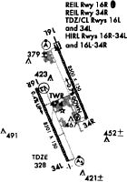
Runways
Runway Summary
| Runways: | 16L/34R 16R/34L |
| Longest Runway: | 16L/34R is 8500 ft (2591 m) long |
| Runways with an Instrument Approach: | 16L, 34L |
JAN Airport Runway Details
| Runway 16L/34R | 8500 ft x 150 ft (2591 m x 46 m) | |
| Runway Length Source: | 3RD PARTY SURVEY as of 10/26/2010 | |
| Surface: | Asphalt - Good condition - Saw-cut or plastic grooved | |
| Runway Pavement Class: | 88 /F/C/W/T | |
| Runway Edge Lights: | High Intensity | |
Runway Weight Bearing Capacity (in thousands of pounds) |
||
| Single Wheel Landing Gear: | 75.0 | |
| Dual Wheel Landing Gear: | 200.0 | |
| Dual Tandem Wheel Landing Gear: | 390.0 | |
| Dual Dual Tandem Wheel Landing Gear: | 850.0 | |
Runway 16L |
Runway 34R |
|
Elevation: |
305.2 | 346.4 |
Latitude: |
32-19-41.4993N | 32-18-23.5247N |
Longitude: |
090-04-39.7560W | 090-04-02.6272W |
|
Runway True Alignment: |
158 | 338 |
ILS Type: |
ILS | |
Glide Path Angle: |
3.0 degrees | 3.0 degrees |
Traffic Pattern: |
Left | Left |
Runway Markings Type: |
Precision Instrument | Precision Instrument |
Runway Markings Condition: |
Good | Good |
Object at End: |
TREES | TREES |
Object Height: |
57 | 51 |
Distance from End: |
2500 | 2750 |
Object Centerline Offset: |
35 ft. left of centerline | 650 ft. right of centerline |
Visual Glide Slope Indicators: |
4-Light PAPI On Left Side Of Runway | 4-Light PAPI On Right Side Of Runway |
Runway Visual Range (RVR): |
Touchdown, Midfield, Rollout | Touchdown, Midfield, Rollout |
Approach Light System: |
Standard 2,400 Foot High Intensity Approach Lighting System With Sequenced Flashers, Cat. II or III Config. | |
REIL: |
Yes | |
Touchdown Lights: |
Yes | No |
Centerline Lights: |
Yes | Yes |
Threshold Crossing Height: |
71 | 66 |
| Runway 16R/34L | 8500 ft x 150 ft (2591 m x 46 m) | |
| Runway Length Source: | 3RD PARTY SURVEY as of 10/26/2010 | |
| Surface: | Asphalt - Good condition - Saw-cut or plastic grooved | |
| Runway Pavement Class: | 59 /F/B/X/U | |
| Runway Edge Lights: | High Intensity | |
Runway Weight Bearing Capacity (in thousands of pounds) |
||
| Single Wheel Landing Gear: | 130.0 | |
| Dual Wheel Landing Gear: | 140.0 | |
| Dual Tandem Wheel Landing Gear: | 250.0 | |
| Dual Dual Tandem Wheel Landing Gear: | 720.0 | |
Runway 16R |
Runway 34L |
|
Elevation: |
305.0 | 328.8 |
Latitude: |
32-18-56.9555N | 32-17-38.9824N |
Longitude: |
090-05-03.7951W | 090-04-26.6710W |
|
Runway True Alignment: |
158 | 338 |
ILS Type: |
ILS | |
Glide Path Angle: |
3.0 degrees | 0.0 degrees |
Traffic Pattern: |
Left | Left |
Runway Markings Type: |
Precision Instrument | Precision Instrument |
Runway Markings Condition: |
Good | Good |
Object at End: |
TREES | |
Object Height: |
78 | |
Distance from End: |
4100 | |
Object Centerline Offset: |
35 ft. left of centerline | 650 ft. right of centerline |
Visual Glide Slope Indicators: |
4-Light PAPI On Left Side Of Runway | |
Runway Visual Range (RVR): |
Rollout | Touchdown |
Approach Light System: |
1,400 Foot Medium Intensity Approach Lighting System With Runway Alignment Indicator Lights | |
REIL: |
Yes | |
Touchdown Lights: |
Yes | |
Centerline Lights: |
Yes | Yes |
Threshold Crossing Height: |
80 |
Services
Airframe Repair: |
Major |
Powerplant Repair: |
Major |
Bottled Oxygen: |
None |
Bulk Oxygen: |
None |
Fuel Available: |
100LL, Jet A |
Landing Fees: |
No |
Parking: |
Hangars and tiedowns available |
Maps & Diagrams
JAN Sectional
Flight Planning
at skyvector.com
at skyvector.com