Location
Latitude: |
42-48-21.5000N (42.805972) |
Longitude: |
102-10-30.9000W (-102.17525) |
Elevation: |
3562.1 feet MSL (1086 m MSL) |
Magnetic Variation: |
6.3 E (as of April 2024 from WMM2020 model) |
Time Zone: |
UTC -7.0 (Standard Time) UTC -6.0 (Daylight Savings Time) |
From City: |
01 N.M. E of Gordon, Nebraska |
Found On: |
Cheyenne Chart |
FAA Region: |
ACE |
Contacts
Manager: |
Publicly owned: |
| GLEN SPAUGH PO BOX 310 GORDON, NE 69343-0310 308-282-0837 |
GORDON ARPT AUTH PO BOX 310 GORDON, NE 69343-0310 308-282-0837 |
Operations
Airport Status: |
Operational |
Facility Use: |
Public |
Type: |
Airport |
Activation Date: |
02/1946 |
Control tower: |
No |
Attendance (Months/Days/Hours): |
Months/Days/Hours ALL/MON-FRI/0800-1700 |
Boundary ARTCC: |
ZDV (Denver) |
Responsible ARTCC: |
ZDV (Denver) |
Lighting Schedule: |
SEE RMK |
Segmented Circle Indicator: |
No |
Traffic Pattern Altitude (MSL): |
4562 feet (1390 m) |
NOTAMs Facility: |
OLU |
NOTAM-D Service: |
Yes |
International Airport of Entry: |
No |
Customs Landing Rights: |
No |
Military Landing Rights: |
Yes |
Civil/Military Joint Use: |
No |
Based Aircraft
| Single Engine: | 8 |
| Multi Engine: | 1 |
Annual Operations (as of 08/09/2023)
| Total Operations: | 1500 | |
| GA Local: | 900 | 60.0% |
| GA Itinerant: | 600 | 40.0% |
Communications
| CTAF: | 122.800 |
| Unicom: | 122.800 |
| AWOS-3PT: | 118.2 (308-282-0127) |
- APCH/DEP CTL SVC PRVDD BY DENVER ARTCC (ZDV) ON FREQS 127.95/338.2 (CRAWFORD RCAG).
Fixed Based Operators (FBOs) & Fuel
(Click on a business for detail)
Please help us keep this information up to date. This is a FREE SERVICE just like everything else on Airport Guide! If you see that a business needs to be added, modified, or deleted please fill out our Update Form.
To add, modify, or delete a business click here.
Please help us keep this information up to date. This is a FREE SERVICE just like everything else on Airport Guide! If you see that a business needs to be added, modified, or deleted please fill out our Update Form.
Area Code: 308 |
| Business Name | Frequency | Phone | Fuel Grade |
|---|---|---|---|
| Centeral States Aircraft
Update FBO info |
Unicom 122.8 | 282-1700 | 100LL, MOGAS |
Flight Service Stations
| Primary | Alternate | |
| FSS on Field: | N | |
| FSS Name (ID): | Columbus(OLU) | |
| Frequency: | ||
| Toll Free Phone: | 1-800-WX-BRIEF |
Instrument Procedures / Charts
FAA Terminal Procedures valid from 0901Z 03/21/24 to 0901Z 04/18/24.
There are various types of charts available for an airport. They are listed in the Page Type column. Here is a legend for those types:
APD - Airport Diagram
DP - Departure Procedure Charts
HOT - Hot Spots
IAP - Instrument Approach Procedure Charts
MIN - Minimums
STAR - Standard Terminal Arrival Charts
| Page Type | Page Name | Volume | Action Since Last Cycle |
|---|---|---|---|
| IAP | NDB RWY 22 | NC-2 | |
| IAP | RNAV (GPS) RWY 04 | NC-2 | |
| IAP | RNAV (GPS) RWY 22 | NC-2 | |
| MIN | ALTERNATE MINIMUMS | NC-2 | |
| MIN | TAKEOFF MINIMUMS | NC-2 |
Terminal Procedures are only available for airports in several countries with more being added all the time. If you are looking for a specific country's charts, please send an email to support(at)airportguide.com stating the country name. This will be used to prioritize the implementation.
Navigation Aids (Navaids) near GRN
| Dist (NM) | ID | Morse Code | Name | Type | Freq | True Hdg | Mag Hdg |
|---|---|---|---|---|---|---|---|
| 0.3 | GRN | _ _ . . _ . _ . | Gordon | NDB | 414 | 212 | 206 |
| 40.4 | HIN | . . . . . . _ . | Whitney | NDB | 275 | 272 | 265 |
| 44.1 | CD | _ . _ . _ . . | Dawes | NDB | 362 | 266 | 259 |
| 52.3 | TST | _ . . . _ | Toadstool | VOR-DME | 113.40 | 253 | 246 |
| 52.9 | AIA | . _ . . . _ | Alliance | VOR-DME | 111.80 | 211 | 205 |
| 53.5 | ALU | . _ . _ . . . . _ | Alliance | NDB | 380 | 211 | 205 |
| 71.6 | VTN | . . . _ _ _ . | Valentine | NDB | 314 | 86 | 80 |
| 78.3 | RA | . _ . . _ | Ranch | NDB | 254 | 332 | 325 |
| 78.4 | PHP | . _ _ . . . . . . _ _ . | Philip | VOR-DME | 108.40 | 16 | 10 |
| 79.1 | RAP | . _ . . _ . _ _ . | Rapid City | VORTAC | 112.30 | 332 | 325 |
| 79.7 | BFF | _ . . . . . _ . . . _ . | Scottsbluff | VORTAC | 112.60 | 227 | 220 |
| 81.3 | TDD | _ _ . . _ . . | Thedford | VOR-DME | 108.60 | 126 | 120 |
| 84.1 | BF | _ . . . . . _ . | Creve | NDB | 263 | 224 | 217 |
| 84.7 | OKS | _ _ _ _ . _ . . . | Oshkosh | NDB | 233 | 185 | 179 |
| 89.6 | RCA | . _ . _ . _ . . _ | Ellsworth | TACAN | 108.80 | 333 | 326 |
| 97.4 | ANW | . _ _ . . _ _ | Ainsworth | VOR-DME | 112.70 | 97 | 91 |
| 98.2 | TOR | _ _ _ _ . _ . | Torrington | NDB | 293 | 243 | 236 |
Nearby Airports with Fuel
| Dist (NM) | Name (Airport IDs) | True Hdg | Mag Hdg | Fuel Grade |
|---|---|---|---|---|
| 40.5 | Chadron Municipal Airport (CDR KCDR CDR) |
272 | 265 | 100LL, Jet A |
| 51.0 | Grant County Airport (1V2) |
159 | 153 | 100LL |
| 53.1 | Alliance Municipal Airport (AIA KAIA AIA) |
211 | 204 | 100LL, Jet A |
| 63.0 | Hot Springs Municipal Airport (KHSR HSR) |
302 | 295 | 100LL |
| 71.6 | Miller Field Airport (VTN KVTN VTN) |
87 | 82 | 100LL, Jet A |
| 78.7 | Philip Airport (PHP KPHP PHP) |
18 | 12 | 100LL |
| 83.7 | Rapid City Regional Airport (RAP KRAP RAP) |
332 | 325 | 100LL, Jet A |
| 84.2 | Western Nebraska Regional/William B Heilig Field Airport (BFF KBFF BFF) |
228 | 221 | 100LL, Jet A |
| 87.3 | Thomas County Airport (KTIF TIF) |
124 | 119 | 100LL, Jet A |
| 97.2 | Ainsworth Regional Airport (ANW KANW ANW) |
97 | 92 | 100LL, Jet A |
| 98.2 | Torrington Municipal Airport (TOR KTOR TOR) |
243 | 236 | 100LL, Jet A+ |
| 98.2 | Lusk Municipal Airport (LSK KLSK LSK) |
268 | 260 | 100LL |
Notices to Airmen (NOTAMS)
Remarks
| A11 | MARK KRUGER (605) 840-0177. |
| A110-1 | FOR CD CTC DENVER ARTCC AT 303-651-4257. |
| A17 | FOR SVC AFTER HRS CALL 308-360-1906 OR 308-360-2120. |
| A30-11/29 | MARKINGS FADED. |
| A33-11/29 | WEEDS IN PAVEMENT; MED & HIGH SEVERITY CRACKS IN PAVEMENT. |
| A70-FUEL-10 | 0LL AVGAS AVBL. |
| A76 | INSTR PART-TIME; HANGAR OVERNIGHT; COURTESY CAR. |
| A81-APT | ACTVT MIRL RWY 4/22 & 11/29 - CTAF; PAPI RWY 04 & 22 ON 24 HRS. |
| E111 | ESTABLISHED PRIOR TO 1959. |
Runways
Runway Summary
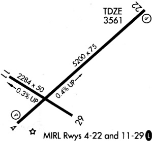
| Runways: | 04/22 11/29 |
| Longest Runway: | 04/22 is 5196 ft (1584 m) long |
| Runways with an Instrument Approach: |
GRN Airport Runway Details
| Runway 04/22 | 5196 ft x 75 ft (1584 m x 23 m) | |
| Surface: | Asphalt - Good condition - No special surface treatment | |
| Runway Edge Lights: | Medium Intensity | |
Runway Weight Bearing Capacity (in thousands of pounds) |
||
| Single Wheel Landing Gear: | 12.0 | |
Runway 04 |
Runway 22 |
|
Elevation: |
3543.5 | 3562.1 |
Latitude: |
42-48-07.1955N | 42-48-41.0495N |
Longitude: |
102-10-52.1960W | 102-09-59.8271W |
|
Runway True Alignment: |
049 | 229 |
Glide Path Angle: |
3.0 degrees | 3.0 degrees |
Traffic Pattern: |
Left | Left |
Runway Markings Type: |
Nonprecision Instrument | Nonprecision Instrument |
Runway Markings Condition: |
Good | Good |
Object at End: |
TREES | ROAD |
Object Height: |
57 | 21 |
Distance from End: |
1213 | 673 |
Object Centerline Offset: |
197 ft. right of centerline | 0 ft. left and right of centerline |
Visual Glide Slope Indicators: |
2-Light PAPI On Left Side Of Runway | 2-Light PAPI On Left Side Of Runway |
Threshold Crossing Height: |
39 | 39 |
| Runway 11/29 | 2284 ft x 50 ft (696 m x 15 m) | |
| Surface: | Asphalt - Good condition - No special surface treatment | |
| Runway Edge Lights: | Medium Intensity | |
Runway Weight Bearing Capacity (in thousands of pounds) |
||
| Single Wheel Landing Gear: | 12.0 | |
Runway 11 |
Runway 29 |
|
Elevation: |
3548.9 | 3542.1 |
Latitude: |
42-48-21.6978N | 42-48-09.5026N |
Longitude: |
102-10-54.9159W | 102-10-29.1442W |
|
Runway True Alignment: |
123 | 303 |
Glide Path Angle: |
0.0 degrees | 0.0 degrees |
Traffic Pattern: |
Left | Left |
Runway Markings Type: |
Basic | Basic |
Runway Markings Condition: |
Fair | Fair |
Object at End: |
ROAD | FENCE |
Object Height: |
15 | 3 |
Distance from End: |
433 | 222 |
Object Centerline Offset: |
197 ft. right of centerline | 0 ft. left and right of centerline |
Services
Airframe Repair: |
None |
Powerplant Repair: |
None |
Bottled Oxygen: |
None |
Bulk Oxygen: |
None |
Fuel Available: |
100LL |
Landing Fees: |
No |
Parking: |
Tiedowns available |
Maps & Diagrams
GRN Sectional
Flight Planning
at skyvector.com
at skyvector.com