Location
Latitude: |
40-56-16.8019N (40.938) |
Longitude: |
090-25-52.0449W (-90.431123) |
Elevation: |
764.3 feet MSL (233 m MSL) |
Magnetic Variation: |
1.9 W (as of April 2024 from WMM2020 model) |
Time Zone: |
UTC -6.0 (Standard Time) UTC -5.0 (Daylight Savings Time) |
From City: |
03 N.M. SW of Galesburg, Illinois |
Found On: |
Chicago Chart |
FAA Region: |
AGL |
Contacts
Manager: |
Publicly owned: |
| MICHAEL DOI 55 W. TOMPKINS ST GALESBURG, IL 61401 (309) 342-3134 |
CITY OF GALESBURG 55 W. TOMPKINS ST GALESBURG, IL 61401 (309) 342-3134 |
Operations
Airport Status: |
Operational |
Facility Use: |
Public |
Type: |
Airport |
Activation Date: |
02/1957 |
Control tower: |
No |
Attendance (Months/Days/Hours): |
Months/Days/Hours ALL/MON-FRI/0700-1900 |
Boundary ARTCC: |
ZAU (Chicago) |
Responsible ARTCC: |
ZAU (Chicago) |
Lighting Schedule: |
SEE RMK |
Segmented Circle Indicator: |
Yes |
Traffic Pattern Altitude (MSL): |
1764 feet (538 m) |
NOTAMs Facility: |
GBG |
NOTAM-D Service: |
Yes |
International Airport of Entry: |
No |
Customs Landing Rights: |
No |
Military Landing Rights: |
Yes |
Civil/Military Joint Use: |
No |
Based Aircraft
| Single Engine: | 18 |
| Multi Engine: | 1 |
| Jet Engine: | 2 |
| Ultralights: | 1 |
Annual Operations (as of 08/31/2023)
| Total Operations: | 14000 | |
| Air Taxi: | 2500 | 17.9% |
| GA Local: | 3500 | 25.0% |
| GA Itinerant: | 7550 | 53.9% |
| Military Aircraft: | 450 | 3.2% |
Communications
| CTAF: | 123.000 |
| Unicom: | 123.000 |
| Clearance Del.: | 120.7 120.7 120.7 |
| Approach: | QUAD CITY CHICAGO ARTCC |
| Departure: | QUAD CITY CHICAGO ARTCC |
| AWOS-3: | 118.975 (309-343-3711) |
- APCH/DEP SVC PRVDD BY CHICAGO ARTCC ON FREQS 135.6/316.1 (BURLINGTON RCAG) WHEN QUAD CITY APCH CTL CLSD.
Fixed Based Operators (FBOs) & Fuel
(Click on a business for detail)
Please help us keep this information up to date. This is a FREE SERVICE just like everything else on Airport Guide! If you see that a business needs to be added, modified, or deleted please fill out our Update Form.
To add, modify, or delete a business click here.
Please help us keep this information up to date. This is a FREE SERVICE just like everything else on Airport Guide! If you see that a business needs to be added, modified, or deleted please fill out our Update Form.
Area Code: 309 |
| Business Name | Frequency | Phone | Fuel Grade |
|---|---|---|---|
| JET Air, Inc.
Update FBO info |
Unicom 123.0 | 342-3134 | 100LL, Jet A |
Flight Service Stations
| Primary | Alternate | |
| FSS on Field: | N | |
| FSS Name (ID): | Kankakee(IKK) | |
| Frequency: | ||
| Toll Free Phone: | 1-800-WX-BRIEF |
Instrument Procedures / Charts
FAA Terminal Procedures valid from 0901Z 03/21/24 to 0901Z 04/18/24.
There are various types of charts available for an airport. They are listed in the Page Type column. Here is a legend for those types:
APD - Airport Diagram
DP - Departure Procedure Charts
HOT - Hot Spots
IAP - Instrument Approach Procedure Charts
MIN - Minimums
STAR - Standard Terminal Arrival Charts
| Page Type | Page Name | Volume | Action Since Last Cycle |
|---|---|---|---|
| IAP | ILS OR LOC RWY 03 | EC-3 | |
| IAP | RNAV (GPS) RWY 03 | EC-3 | |
| IAP | RNAV (GPS) RWY 21 | EC-3 | |
| MIN | ALTERNATE MINIMUMS | EC-3 | |
| MIN | TAKEOFF MINIMUMS | EC-3 |
Terminal Procedures are only available for airports in several countries with more being added all the time. If you are looking for a specific country's charts, please send an email to support(at)airportguide.com stating the country name. This will be used to prioritize the implementation.
Navigation Aids (Navaids) near GBG
| Dist (NM) | ID | Morse Code | Name | Type | Freq | True Hdg | Mag Hdg |
|---|---|---|---|---|---|---|---|
| 0.2 | GBG | _ _ . _ . . . _ _ . | Galesburg | DME | 109.8 | 254 | 256 |
| 24.8 | MZV | _ _ _ _ . . . . . _ | Moline | VOR-DME | 114.40 | 337 | 339 |
| 25.9 | JZY | . _ _ _ _ _ . . _ . _ _ | Macomb | NDB | 251 | 193 | 195 |
| 25.9 | BRL | _ . . . . _ . . _ . . | Burlington | VOR-DME | 111.40 | 240 | 242 |
| 27.5 | CTK | _ . _ . _ _ . _ | Canton | NDB | 236 | 144 | 146 |
| 32.9 | PIA | . _ _ . . . . _ | Peoria | VORTAC | 115.20 | 117 | 119 |
| 35.7 | BR | _ . . . . _ . | Burns | NDB | 390 | 241 | 243 |
| 40.4 | BDF | _ . . . _ . . . . _ . | Bradford | VORTAC | 114.70 | 70 | 72 |
| 41.0 | DVN | _ . . . . . _ _ . | Davenport Municipal | VOT | 111.80 | 350 | 352 |
| 41.4 | DDD | _ . . _ . . _ . . | Port City | DME | 116.5 | 308 | 310 |
| 43.0 | PI | . _ _ . . . | Tungg | NDB | 356 | 117 | 119 |
| 46.3 | CVA | _ . _ . . . . _ . _ | Davenport | VORTAC | 113.80 | 357 | 359 |
| 48.8 | FN | . . _ . _ . | Hillz | NDB | 517 | 2 | 4 |
| 49.1 | MPZ | _ _ . _ _ . _ _ . . | Mount Pleasant | NDB | 212 | 271 | 273 |
| 53.7 | EOK | . _ _ _ _ . _ | Keokuk | NDB | 366 | 238 | 240 |
| 54.8 | BOZ | _ . . . _ _ _ _ _ . . | Whiteside | NDB | 254 | 31 | 33 |
| 59.8 | AWG | . _ . _ _ _ _ . | Washington | NDB | 219 | 290 | 291 |
| 63.7 | IOW | . . _ _ _ . _ _ | Iowa City | VOR-DME | 116.20 | 303 | 305 |
| 68.3 | AAA | . _ . _ . _ | Abraham | NDB | 329 | 132 | 134 |
| 70.2 | IJX | . . . _ _ _ _ . . _ | Jacksonville | DME | 108.6 | 172 | 174 |
Nearby Airports with Fuel
Notices to Airmen (NOTAMS)
Remarks
| A70-FUEL-10 | 0LL SELF SERVE 100LL AVAILABLE 24 HRS. |
| A81-APT | HIRL RWY 03/21 & MIRL RWY 10/28 PRESET ON LOW INTST NIGHT; TO INCR INTST NIGHT & ACTVT MALSR RWY 03; REIL RWY 21; PAPI RWY 21; HIRL RWY 03/21 & MIRL RWY 10/28 DAY - CTAF. |
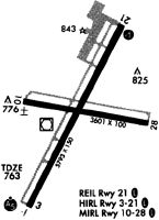
Runways
Runway Summary
| Runways: | 03/21 10/28 |
| Longest Runway: | 03/21 is 5792 ft (1765 m) long |
| Runways with an Instrument Approach: | 03 |
GBG Airport Runway Details
| Runway 03/21 | 5792 ft x 150 ft (1765 m x 46 m) | |
| Runway Length Source: | 3RD PARTY SURVEY as of 07/20/2012 | |
| Surface: | Asphalt - Good condition - Porous friction course | |
| Runway Edge Lights: | High Intensity | |
Runway Weight Bearing Capacity (in thousands of pounds) |
||
| Single Wheel Landing Gear: | 47.0 | |
| Dual Wheel Landing Gear: | 57.0 | |
| Dual Tandem Wheel Landing Gear: | 85.0 | |
Runway 03 |
Runway 21 |
|
Elevation: |
754.5 | 764.3 |
Latitude: |
40-55-51.2446N | 40-56-41.6915N |
Longitude: |
090-26-11.3525W | 090-25-35.7293W |
|
Runway True Alignment: |
028 | 208 |
ILS Type: |
ILS | |
Glide Path Angle: |
0.0 degrees | 3.0 degrees |
Traffic Pattern: |
Left | Left |
Runway Markings Type: |
Precision Instrument | Nonprecision Instrument |
Runway Markings Condition: |
Good | Good |
Object at End: |
TREE | TREE |
Object Height: |
18 | 57 |
Distance from End: |
1007 | 1731 |
Object Centerline Offset: |
182 ft. left of centerline | 623 ft. left of centerline |
Visual Glide Slope Indicators: |
4-Light PAPI On Left Side Of Runway | |
Approach Light System: |
1,400 Foot Medium Intensity Approach Lighting System With Runway Alignment Indicator Lights | |
REIL: |
Yes | |
Touchdown Lights: |
No | No |
Centerline Lights: |
No | No |
Threshold Crossing Height: |
55 |
| Runway 10/28 | 3600 ft x 100 ft (1097 m x 30 m) | |
| Runway Length Source: | 3RD PARTY SURVEY as of 07/20/2012 | |
| Surface: | Asphalt - Good condition - No special surface treatment | |
| Runway Edge Lights: | Medium Intensity | |
Runway Weight Bearing Capacity (in thousands of pounds) |
||
| Single Wheel Landing Gear: | 30.0 | |
| Dual Wheel Landing Gear: | 40.0 | |
Runway 10 |
Runway 28 |
|
Elevation: |
757.5 | 757.5 |
Latitude: |
40-56-20.7363N | 40-56-13.9420N |
Longitude: |
090-26-12.6602W | 090-25-26.6158W |
|
Runway True Alignment: |
101 | 281 |
Glide Path Angle: |
0.0 degrees | 0.0 degrees |
Traffic Pattern: |
Left | Left |
Runway Markings Type: |
Basic | Basic |
Runway Markings Condition: |
Good | Good |
Object at End: |
TREE | |
Object Height: |
2 | |
Distance from End: |
207 | |
Object Centerline Offset: |
182 ft. left of centerline | 623 ft. left of centerline |
REIL: |
No | No |
Touchdown Lights: |
No | No |
Centerline Lights: |
No | No |
Services
Airframe Repair: |
Major |
Powerplant Repair: |
Major |
Bottled Oxygen: |
None |
Bulk Oxygen: |
High Pressure |
Fuel Available: |
100LL, Jet A |
Landing Fees: |
No |
Parking: |
Hangars and tiedowns available |
Maps & Diagrams
GBG Sectional
Flight Planning
at skyvector.com
at skyvector.com