Location
Latitude: |
36-26-46.6000N (36.446278) |
Longitude: |
103-08-59.8000W (-103.149944) |
Elevation: |
4969.6 feet MSL (1515 m MSL) |
Magnetic Variation: |
6.4 E (as of April 2024 from WMM2020 model) |
Time Zone: |
UTC -7.0 (Standard Time) UTC -6.0 (Daylight Savings Time) |
From City: |
02 N.M. E of Clayton, New Mexico |
Found On: |
Wichita Chart |
FAA Region: |
ASW |
Contacts
Manager: |
Publicly owned: |
| MICHAEL DEHERRERA 1 CHESTNUT ST CLAYTON, NM 88415 575-374-9873 |
TOWN OF CLAYTON 1 CHESTNUT ST CLAYTON, NM 88415 575-374-8331 |
Operations
Airport Status: |
Operational |
Facility Use: |
Public |
Type: |
Airport |
Activation Date: |
12/1946 |
Control tower: |
No |
Attendance (Months/Days/Hours): |
Months/Days/Hours ALL/ALL/0800-1700 |
Boundary ARTCC: |
ZAB (Albuquerque) |
Responsible ARTCC: |
ZAB (Albuquerque) |
Lighting Schedule: |
SEE RMK |
Segmented Circle Indicator: |
Yes |
Traffic Pattern Altitude (MSL): |
5970 feet (1820 m) |
NOTAMs Facility: |
CAO |
NOTAM-D Service: |
Yes |
International Airport of Entry: |
No |
Customs Landing Rights: |
No |
Military Landing Rights: |
Yes |
Civil/Military Joint Use: |
No |
Based Aircraft
| Single Engine: | 10 |
Annual Operations (as of 04/21/2022)
| Total Operations: | 3300 | |
| GA Local: | 1500 | 45.5% |
| GA Itinerant: | 1800 | 54.5% |
Communications
| CTAF: | 122.800 |
| Unicom: | 122.800 |
| ASOS: | 120.625 (575-374-2565) |
- APCH/DEP SVC PRVDD BY ALBUQUERQUE ARTCC (ABQ) ON FREQS 127.85/285.475 (MOUNT DORA RCAG).
Fixed Based Operators (FBOs) & Fuel
(Click on a business for detail)
Please help us keep this information up to date. This is a FREE SERVICE just like everything else on Airport Guide! If you see that a business needs to be added, modified, or deleted please fill out our Update Form.
To add, modify, or delete a business click here.
Please help us keep this information up to date. This is a FREE SERVICE just like everything else on Airport Guide! If you see that a business needs to be added, modified, or deleted please fill out our Update Form.
Area Code: 505 |
| Business Name | Frequency | Phone | Fuel Grade |
|---|---|---|---|
| Airport Management
Update FBO info |
374-9976, -9973, -9873, after hours call 374-9800 | 100LL, Jet A |
Flight Service Stations
| Primary | Alternate | |
| FSS on Field: | N | |
| FSS Name (ID): | Albuquerque(ABQ) | |
| Frequency: | ||
| Toll Free Phone: | 1-800-WX-BRIEF |
Instrument Procedures / Charts
FAA Terminal Procedures valid from 0901Z 03/21/24 to 0901Z 04/18/24.
There are various types of charts available for an airport. They are listed in the Page Type column. Here is a legend for those types:
APD - Airport Diagram
DP - Departure Procedure Charts
HOT - Hot Spots
IAP - Instrument Approach Procedure Charts
MIN - Minimums
STAR - Standard Terminal Arrival Charts
| Page Type | Page Name | Volume | Action Since Last Cycle |
|---|---|---|---|
| IAP | RNAV (GPS) RWY 02 | SW-1 | |
| IAP | RNAV (GPS) RWY 20 | SW-1 | |
| MIN | ALTERNATE MINIMUMS | SW-1 | |
| MIN | TAKEOFF MINIMUMS | SW-1 |
Terminal Procedures are only available for airports in several countries with more being added all the time. If you are looking for a specific country's charts, please send an email to support(at)airportguide.com stating the country name. This will be used to prioritize the implementation.
Navigation Aids (Navaids) near CAO
| Dist (NM) | ID | Morse Code | Name | Type | Freq | True Hdg | Mag Hdg |
|---|---|---|---|---|---|---|---|
| 0.1 | CAO | _ . _ . . _ _ _ _ | Clayton | NDB | 332 | 168 | 162 |
| 36.2 | DHT | _ . . . . . . _ | Dalhart | VORTAC | 112.00 | 125 | 119 |
| 53.3 | TBE | _ _ . . . . | Tobe | VOR-DME | 114.05 | 336 | 329 |
| 69.4 | EHA | . . . . . . _ | Elkhart | NDB | 377 | 60 | 54 |
| 76.7 | TAD | _ . _ _ . . | Trinidad | NDB | 329 | 312 | 305 |
| 78.9 | TCC | _ _ . _ . _ . _ . | Tucumcari | VORTAC | 113.60 | 196 | 190 |
| 80.8 | GUY | _ _ . . . _ _ . _ _ | Guymon | NDB | 275 | 78 | 72 |
| 83.1 | CIM | _ . _ . . . _ _ | Cimarron | VORTAC | 116.40 | 272 | 265 |
| 93.9 | BGD | _ . . . _ _ . _ . . | Borger | TACAN | 108.60 | 113 | 107 |
| 95.5 | HQG | . . . . _ _ . _ _ _ . | Hugoton | NDB | 365 | 62 | 56 |
| 98.4 | JHN | . _ _ _ . . . . _ . | Bear Creek | NDB | 341 | 43 | 37 |
Nearby Airports with Fuel
| Dist (NM) | Name (Airport IDs) | True Hdg | Mag Hdg | Fuel Grade |
|---|---|---|---|---|
| 38.7 | Dalhart Municipal Airport (DHT KDHT DHT) |
130 | 124 | 100LL, Jet A-1 |
| 41.4 | Miller Airfield Airport (25TS) |
120 | 114 | 100LL, MOGAS |
| 65.4 | Moore County Airport (KDUX DUX) |
122 | 116 | 100LL, Jet A |
| 67.5 | Raton Municipal/Crews Field Airport (RTN KRTN RTN) |
285 | 278 | 100LL, Jet A-1+ |
| 75.2 | Perry Stokes Airport (TAD KTAD TAD) |
310 | 303 | 100LL, Jet A |
| 79.0 | Tucumcari Municipal Airport (TCC KTCC TCC) |
196 | 190 | 100LL, Jet A+ |
| 80.5 | Guymon Municipal Airport (GUY KGUY GUY) |
79 | 74 | 100LL, Jet A |
| 96.2 | Hutchinson County Airport (BGD KBGD BGD) |
117 | 112 | 100LL, Jet A, Jet A+ |
| 96.4 | Stanton County Municipal Airport (KJHN JHN) |
44 | 38 | 100LL, Jet A |
| 97.7 | Melon Field Airport (1CO5) |
344 | 337 | 100LL |
| 97.7 | La Junta Municipal Airport (KLHX LHX) |
349 | 342 | 100LL, Jet A |
| 99.9 | Southeast Colorado Regional Airport (LAA KLAA LAA) |
12 | 6 | 100LL, Jet A |
Notices to Airmen (NOTAMS)
Remarks
| A11 | FERON LUCERO. |
| A110-1 | REFLECTORS ALL TWYS. |
| A110-2 | FOR CD CTC ALBUQUERQUE ARTCC AT 505-856-4861. |
| A16 | 575-207-5455. |
| A57-02 | APCH SLOPE 50:1+ TO DTHR. |
| A58-02 | 8 FT ROAD 142 FT FM RWY END BOTH SIDES. |
| A70-FUEL-10 | 0LL 100LL SELF SVC H24 WITH CREDIT CARD. |
| A81-APT | ACTVT PAPI RWY 02 & 20; MIRL RWY 02/20 & 12/30 - CTAF. |
Runways
Runway Summary
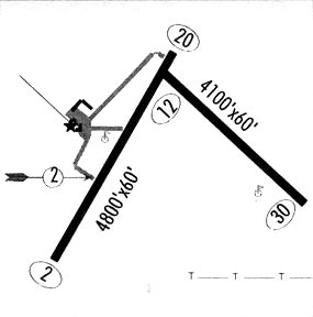
| Runways: | 02/20 12/30 |
| Longest Runway: | 02/20 is 6307 ft (1922 m) long |
| Runways with an Instrument Approach: |
CAO Airport Runway Details
| Runway 02/20 | 6307 ft x 75 ft (1922 m x 23 m) | |
| Runway Length Source: | 3RD PARTY SURVEY as of 05/06/2010 | |
| Surface: | Asphalt - Fair condition - No special surface treatment | |
| Runway Pavement Class: | 6 /F/C/Y/T | |
| Runway Edge Lights: | Medium Intensity | |
Runway Weight Bearing Capacity (in thousands of pounds) |
||
| Single Wheel Landing Gear: | 16.5 | |
Runway 02 |
Runway 20 |
|
Elevation: |
4965.6 | 4969.6 |
Latitude: |
36-26-20.0465N | 36-27-13.9160N |
Longitude: |
103-09-28.4147W | 103-08-49.5561W |
|
Runway True Alignment: |
030 | 210 |
Glide Path Angle: |
3.0 degrees | 3.0 degrees |
Traffic Pattern: |
Left | Left |
Runway Markings Type: |
Nonprecision Instrument | Nonprecision Instrument |
Runway Markings Condition: |
Good | Good |
Visual Glide Slope Indicators: |
2-Light PAPI On Left Side Of Runway | 2-Light PAPI On Left Side Of Runway |
Threshold Crossing Height: |
49 | 49 |
Threshold Elevation: |
4966.2 | |
Displaced Threshold: |
380 | |
Threshold Latitude: |
36-26-23.2875N | |
Threshold Longitude: |
103-09-26.0695W |
| Runway 12/30 | 4106 ft x 60 ft (1252 m x 18 m) | |
| Runway Length Source: | 3RD PARTY SURVEY as of 05/06/2010 | |
| Surface: | Asphalt - Fair condition - No special surface treatment | |
| Runway Pavement Class: | 5 /F/D/Y/T | |
| Runway Edge Lights: | Medium Intensity | |
Runway 12 |
Runway 30 |
|
Elevation: |
4966.3 | 4946.9 |
Latitude: |
36-26-59.2349N | 36-26-33.0204N |
Longitude: |
103-09-04.7474W | 103-08-26.3943W |
|
Runway True Alignment: |
130 | 310 |
Glide Path Angle: |
0.0 degrees | 0.0 degrees |
Runway Markings Type: |
Basic | Basic |
Runway Markings Condition: |
Fair | Fair |
Services
Airframe Repair: |
Major |
Powerplant Repair: |
Major |
Bottled Oxygen: |
Low Pressure |
Bulk Oxygen: |
Low Pressure |
Fuel Available: |
100LL, Jet A |
Landing Fees: |
No |
Parking: |
Hangars and tiedowns available |
Maps & Diagrams
CAO Sectional
Flight Planning
at skyvector.com
at skyvector.com