Location
Latitude: |
43-06-16.9300N (43.104703) |
Longitude: |
089-11-07.3000W (-89.185361) |
Elevation: |
920.0 feet MSL (280 m MSL) |
Magnetic Variation: |
3.1 W (as of April 2024 from WMM2020 model) |
Time Zone: |
UTC -6.0 (Standard Time) UTC -5.0 (Daylight Savings Time) |
From City: |
10 N.M. E of Madison, Wisconsin |
Found On: |
Chicago Chart |
FAA Region: |
AGL |
Contacts
Manager: |
Privately owned: |
| CHERYL STRASSMAN 2534 S FISH HATCHERY ROAD FITCHBURG, WI 53711 (608) 334-4932 |
BLACKHAWK AIRFIELD INC 2534 S FISH HATCHERY ROAD FITCHBURG, WI 53711 (608) 334-4932 |
Operations
Airport Status: |
Operational |
Facility Use: |
Public |
Type: |
Airport |
Activation Date: |
09/1972 |
Control tower: |
No |
Attendance (Months/Days/Hours): |
Months/Days/Hours UNATTND |
Boundary ARTCC: |
ZAU (Chicago) |
Responsible ARTCC: |
ZAU (Chicago) |
Lighting Schedule: |
SS-SR |
Segmented Circle Indicator: |
Yes |
Traffic Pattern Altitude (MSL): |
1920 feet (585 m) |
NOTAMs Facility: |
GRB |
NOTAM-D Service: |
Yes |
Based Aircraft
| Single Engine: | 34 |
Annual Operations (as of 07/22/2022)
| Total Operations: | 2000 | |
| GA Local: | 1000 | 50.0% |
| GA Itinerant: | 1000 | 50.0% |
Communications
| CTAF: | 122.700 |
| Unicom: | 122.700 |
| Approach: | MADISON 120.1 120.1 CHICAGO ARTCC |
| Departure: | MADISON 120.1 120.1 CHICAGO ARTCC |
- APCH/DEP SVC PRVDD BY CHICAGO ARTCC ON FREQS 133.3/257.925 (LONE ROCK RCAG) WHEN MADISON APCH CTL CLSD.
Fixed Based Operators (FBOs) & Fuel
(Click on a business for detail)
Please help us keep this information up to date. This is a FREE SERVICE just like everything else on Airport Guide! If you see that a business needs to be added, modified, or deleted please fill out our Update Form.
To add, modify, or delete a business click here.
Please help us keep this information up to date. This is a FREE SERVICE just like everything else on Airport Guide! If you see that a business needs to be added, modified, or deleted please fill out our Update Form.
Area Code: 608 |
| Business Name | Frequency | Phone | Fuel Grade |
|---|---|---|---|
| Blackhawk Airfield, Inc.
Update FBO info |
Unicom 122.7 | 839-5155 | 100LL |
Flight Service Stations
| Primary | Alternate | |
| FSS on Field: | N | |
| FSS Name (ID): | Green Bay(GRB) | |
| Frequency: | ||
| Toll Free Phone: | 1-800-WX-BRIEF |
Instrument Procedures / Charts
FAA Terminal Procedures valid from 0901Z 03/21/24 to 0901Z 04/18/24.
There are various types of charts available for an airport. They are listed in the Page Type column. Here is a legend for those types:
APD - Airport Diagram
DP - Departure Procedure Charts
HOT - Hot Spots
IAP - Instrument Approach Procedure Charts
MIN - Minimums
STAR - Standard Terminal Arrival Charts
| Page Type | Page Name | Volume | Action Since Last Cycle |
|---|---|---|---|
| IAP | VOR OR GPS-A | EC-3 | |
| MIN | TAKEOFF MINIMUMS | EC-3 |
Terminal Procedures are only available for airports in several countries with more being added all the time. If you are looking for a specific country's charts, please send an email to support(at)airportguide.com stating the country name. This will be used to prioritize the implementation.
Navigation Aids (Navaids) near 87Y
| Dist (NM) | ID | Morse Code | Name | Type | Freq | True Hdg | Mag Hdg |
|---|---|---|---|---|---|---|---|
| 7.2 | MSN | _ _ . . . _ . | Madison | VORTAC | 108.60 | 289 | 292 |
| 7.5 | MS | _ _ . . . | Monah | NDB | 400 | 250 | 253 |
| 20.6 | RYV | . _ . _ . _ _ . . . _ | Rock River | NDB | 371 | 78 | 81 |
| 28.7 | UNU | . . _ _ . . . _ | Juneau | NDB | 344 | 47 | 50 |
| 30.1 | JVL | . _ _ _ . . . _ . _ . . | Janesville | NDB | 375 | 167 | 170 |
| 33.0 | JVL | . _ _ _ . . . _ . _ . . | Janesville | VOR-DME | 114.30 | 173 | 176 |
| 35.6 | LVV | . _ . . . . . _ . . . _ | Lake Lawn | NDB | 404 | 132 | 135 |
| 36.8 | DLL | _ . . . _ . . . _ . . | Dells | VORTAC | 117.00 | 316 | 319 |
| 39.5 | BAE | _ . . . . _ . | Badger | VOR-DME | 116.40 | 88 | 91 |
| 43.0 | LNR | . _ . . _ . . _ . | Lone Rock | DME | 116.05 | 285 | 288 |
| 46.1 | BUU | _ . . . . . _ . . _ | Burbun | DME | 114.5 | 122 | 125 |
| 47.5 | MRJ | _ _ . _ . . _ _ _ | Mineral Point | NDB | 365 | 254 | 257 |
| 50.1 | BJB | _ . . . . _ _ _ _ . . . | West Bend | VOR | 109.80 | 67 | 71 |
| 50.3 | LJT | . _ . . . _ _ _ _ | Timmerman | DME | 115.65 | 89 | 93 |
| 51.6 | GM | _ _ . _ _ | Teels | NDB | 242 | 102 | 106 |
| 52.7 | RFD | . _ . . . _ . _ . . | Rockford | DME | 110.8 | 180 | 183 |
| 53.6 | OS | _ _ _ . . . | Pober | NDB | 395 | 30 | 33 |
| 57.3 | MKE | _ _ _ . _ . | Milwaukee | VOT | 109.00 | 99 | 103 |
| 57.4 | BL | _ . . . . _ . . | Yanks | NDB | 260 | 92 | 96 |
| 59.5 | RF | . _ . . . _ . | Gilmy | NDB | 275 | 176 | 179 |
Nearby Airports with Fuel
Notices to Airmen (NOTAMS)
Remarks
| A110-1 | RWY 09 AVOID OVERFLIGHT OF FARM 3/4 MI EAST. |
| A110-3 | DEER & TURKEYS ON & INVOF ARPT. |
| A110-4 | RWY ENDS OBSTD VISUALLY FM OTRS. |
| A110-5 | FOR CD CTC MADISON APP/DEP CON AT 608-249-8240. WHEN MADISON APCH CLSD, FOR CD CTC CHICAGO ARTCC AT 630-906-8921. |
| A110-6 | COLD TEMPERATURE AIRPORT. ALTITUDE CORRECTION REQUIRED AT OR BELOW -24C. |
| A15 | EMAIL ADDRESS: STRASS32@AMERITECH.NET (ALL LOWER CASE) |
| A33-04/22 | CRACKS WITH VEGETATION. |
| A40-09/27 | NSTD LIRL; RWY LGTS 2 FT TO 3 FT ABOVE RWY & NSTD SPACING. RWY 09/27 LGTD 1973 FT. |
| A42-04 | MARKINGS FADED. |
| A42-09 | MARKINGS FADED. |
| A42-22 | MARKINGS FADED. |
| A42-27 | MARKINGS FADED. |
| A57-22 | APCH RATIO 10:1 TO DTHR. 48 FT TREES 470 FT FM DTHR, 25 FT L. |
| A57-27 | APCH RATIO 20:1 TO DTHR. |
| A58-04 | 20 FT BRUSH 10 FT FM THR. |
| A58-09 | 40 FT TREES 180 FT FM THR, 100 FT L. |
| A58-22 | 45 FT TREES 160 FT FM THR, 25L. |
Runways
Runway Summary
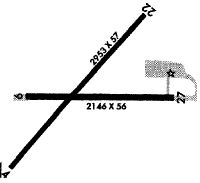
| Runways: | 04/22 09/27 |
| Longest Runway: | 04/22 is 2814 ft (858 m) long |
| Runways with an Instrument Approach: |
87Y Airport Runway Details
| Runway 04/22 | 2814 ft x 57 ft (858 m x 17 m) | |
| Runway Length Source: | STATE as of 02/27/2004 | |
| Surface: | Asphalt - Poor condition - No special surface treatment | |
Runway 04 |
Runway 22 |
|
Elevation: |
914.3 | 900.7 |
Latitude: |
43-06-06.7000N | 43-06-28.0500N |
Longitude: |
089-11-21.6000W | 089-10-57.3200W |
|
Runway True Alignment: |
040 | 220 |
Glide Path Angle: |
0.0 degrees | 0.0 degrees |
Traffic Pattern: |
Right | |
Runway Markings Type: |
Basic | Basic |
Runway Markings Condition: |
Poor | Poor |
Object at End: |
TREES | TREES |
Object Height: |
49 | 48 |
Distance from End: |
334 | 210 |
Object Centerline Offset: |
15 ft. right of centerline | 25 ft. left of centerline |
Threshold Elevation: |
900.7 | |
Displaced Threshold: |
260 | |
Threshold Latitude: |
43-06-26.0800N | |
Threshold Longitude: |
089-10-59.5600W |
| Runway 09/27 | 2203 ft x 56 ft (671 m x 17 m) | |
| Runway Length Source: | STATE as of 01/15/2003 | |
| Surface: | Asphalt - Poor condition - No special surface treatment | |
| Runway Edge Lights: | Non-standard lighting system Intensity | |
Runway 09 |
Runway 27 |
|
Elevation: |
920.0 | 905.0 |
Latitude: |
43-06-16.2000N | 43-06-16.5000N |
Longitude: |
089-11-19.4000W | 089-10-49.7000W |
|
Runway True Alignment: |
089 | 270 |
Glide Path Angle: |
0.0 degrees | 0.0 degrees |
Traffic Pattern: |
Right | |
Runway Markings Type: |
Basic | Basic |
Runway Markings Condition: |
Poor | Poor |
Object at End: |
ROAD | ROAD |
Object Height: |
15 | 16 |
Distance from End: |
210 | 257 |
Object Centerline Offset: |
15 ft. right of centerline | 25 ft. left of centerline |
Touchdown Lights: |
No | No |
Centerline Lights: |
No | No |
Threshold Elevation: |
905.0 | |
Displaced Threshold: |
230 | |
Threshold Latitude: |
43-06-16.4700N | |
Threshold Longitude: |
089-10-52.8000W |
Services
Airframe Repair: |
None |
Powerplant Repair: |
None |
Bottled Oxygen: |
None |
Bulk Oxygen: |
None |
Fuel Available: |
80, 100LL |
Landing Fees: |
No |
Parking: |
Tiedowns available |
Maps & Diagrams
87Y Sectional
Flight Planning
at skyvector.com
at skyvector.com