Location
Latitude: |
39-02-36.0000N (39.043333) |
Longitude: |
096-50-35.8000W (-96.843278) |
Elevation: |
1101.6 feet MSL (336 m MSL) |
Magnetic Variation: |
2.7 E (as of April 2024 from WMM2020 model) |
Time Zone: |
UTC -6.0 (Standard Time) UTC -5.0 (Daylight Savings Time) |
From City: |
01 N.M. NW of Junction City, Kansas |
Found On: |
Kansas City Chart |
FAA Region: |
ACE |
Contacts
Manager: |
Publicly owned: |
| MARVIN HORNBOSTEL RAVEN AREO SERVICES JUNCTION CITY, KS 66441 (785) 761-7692 |
CITY OF JUNCTION CITY PO BOX 287 JUNCTION CITY, KS 66441 785-238-3103 |
Operations
Airport Status: |
Operational |
Facility Use: |
Public |
Type: |
Airport |
Activation Date: |
09/1949 |
Control tower: |
No |
Attendance (Months/Days/Hours): |
Months/Days/Hours ALL/ALL/0800-1700 |
Boundary ARTCC: |
ZKC (Kansas City) |
Responsible ARTCC: |
ZKC (Kansas City) |
Lighting Schedule: |
SEE RMK |
Segmented Circle Indicator: |
Yes |
Traffic Pattern Altitude (MSL): |
2102 feet (641 m) |
NOTAMs Facility: |
ICT |
NOTAM-D Service: |
Yes |
International Airport of Entry: |
No |
Customs Landing Rights: |
No |
Military Landing Rights: |
Yes |
Civil/Military Joint Use: |
No |
Based Aircraft
| Single Engine: | 22 |
| Multi Engine: | 3 |
| GA Helicopters: | 1 |
Annual Operations (as of 10/24/2022)
| Total Operations: | 2700 | |
| GA Local: | 1350 | 50.0% |
| GA Itinerant: | 1350 | 50.0% |
Communications
| CTAF: | 122.800 |
| Unicom: | 122.800 |
| Approach: | MARSHALL AAF GCA 121.25 121.25 KANSAS CITY ARTCC |
| Departure: | MARSHALL AAF GCA 121.25 121.25 KANSAS CITY ARTCC |
- APCH/DEP CTL SVC PRVDD BY KANSAS CITY ARTCC (ZKC) ON FREQS 127.35/257.975 (MANHATTAN RCAG) WHEN MARSHALL APCH CTL (FRI) CLSD.
Fixed Based Operators (FBOs) & Fuel
(Click on a business for detail)
Please help us keep this information up to date. This is a FREE SERVICE just like everything else on Airport Guide! If you see that a business needs to be added, modified, or deleted please fill out our Update Form.
To add, modify, or delete a business click here.
Please help us keep this information up to date. This is a FREE SERVICE just like everything else on Airport Guide! If you see that a business needs to be added, modified, or deleted please fill out our Update Form.
Area Code: 785 |
| Business Name | Frequency | Phone | Fuel Grade |
|---|---|---|---|
| Kansas Air Center
Update FBO info |
238-1991 | 100LL, MOGAS |
Flight Service Stations
| Primary | Alternate | |
| FSS on Field: | N | |
| FSS Name (ID): | Wichita(ICT) | |
| Frequency: | ||
| Toll Free Phone: | 1-800-WX-BRIEF |
Instrument Procedures / Charts
FAA Terminal Procedures valid from 0901Z 03/21/24 to 0901Z 04/18/24.
There are various types of charts available for an airport. They are listed in the Page Type column. Here is a legend for those types:
APD - Airport Diagram
DP - Departure Procedure Charts
HOT - Hot Spots
IAP - Instrument Approach Procedure Charts
MIN - Minimums
STAR - Standard Terminal Arrival Charts
| Page Type | Page Name | Volume | Action Since Last Cycle |
|---|---|---|---|
| IAP | RNAV (GPS) RWY 36 | NC-2 | |
| MIN | TAKEOFF MINIMUMS | NC-2 |
Terminal Procedures are only available for airports in several countries with more being added all the time. If you are looking for a specific country's charts, please send an email to support(at)airportguide.com stating the country name. This will be used to prioritize the implementation.
Navigation Aids (Navaids) near 3JC
| Dist (NM) | ID | Morse Code | Name | Type | Freq | True Hdg | Mag Hdg |
|---|---|---|---|---|---|---|---|
| 2.5 | CVY | _ . _ . . . . _ _ . _ _ | Cavalry | NDB | 314 | 114 | 111 |
| 4.5 | FRI | . . _ . . _ . . . | Fort Riley | VOR | 109.40 | 190 | 187 |
| 10.2 | MHK | _ _ . . . . _ . _ | Manhattan | VOR-DME | 110.20 | 52 | 49 |
| 21.1 | HRU | . . . . . _ . . . _ | Herington | NDB | 407 | 175 | 172 |
| 25.1 | CYW | _ . _ . _ . _ _ . _ _ | Clay Center | NDB | 362 | 323 | 320 |
| 37.0 | SLN | . . . . _ . . _ . | Salina | VORTAC | 117.10 | 259 | 256 |
| 43.3 | SL | . . . . _ . . | Flory | NDB | 344 | 240 | 237 |
| 48.4 | CNK | _ . _ . _ . _ . _ | Concordia | NDB | 335 | 309 | 306 |
| 54.0 | TO | _ _ _ _ | Biloy | NDB | 521 | 84 | 82 |
| 55.1 | FOE | . . _ . _ _ _ . | Forbes | VOT | 111.00 | 95 | 93 |
| 55.4 | FOE | . . _ . _ _ _ . | Forbes | TACAN | 111.60 | 95 | 93 |
| 55.9 | EMP | . _ _ . _ _ . | Emporia | VORTAC | 112.80 | 143 | 141 |
| 57.4 | MPR | _ _ . _ _ . . _ . | Mc Pherson | NDB | 227 | 223 | 220 |
| 57.6 | CA | _ . _ . . _ | Harvs | NDB | 395 | 200 | 197 |
| 59.6 | FO | . . _ . _ _ _ | Riply | NDB | 326 | 98 | 96 |
| 59.7 | RPB | . _ . . _ _ . _ . . . | Republican | NDB | 414 | 321 | 318 |
| 60.5 | TOP | _ _ _ _ . _ _ . | Topeka | VORTAC | 117.80 | 84 | 82 |
| 62.1 | EWK | . . _ _ _ . _ | Newton | NDB | 281 | 199 | 196 |
| 68.9 | UKL | . . _ _ . _ . _ . . | Boyd | NDB | 245 | 129 | 127 |
| 69.6 | FBY | . . _ . _ . . . _ . _ _ | Fairbury | NDB | 293 | 347 | 344 |
Nearby Airports with Fuel
Notices to Airmen (NOTAMS)
Remarks
| A110-1 | ARPT SFC CONDS: RWY, TWY & APRON FAIR. TURF SOFT WHEN WET. |
| A110-3 | NON-STD ATC MINIMA APPLIED IFR ARVLS WITH RESPECT TO HI-PERFORMANCE-ACFT OPNS CONDUCTED WITHIN CFNS OF R-3602. |
| A110-5 | WATERFOWL ON & INVOF ARPT. |
| A110-6 | FOR CD CTC MARSHALL APCH AT 785-239-2118. WHEN MARSHALL APCH IS CLSD, CTC KANSAS CITY ARTCC AT 913-254-8508. |
| A110-7 | COLD TEMPERATURE AIRPORT. ALTITUDE CORRECTION REQUIRED AT OR BELOW -23C. |
| A110-8 | BASEBALL FIELD LGT POLES 918 FT TO 1303 FT FM RWY END, 338 FT TO 672 FT RIGHT, 1175 FT AMSL. |
| A14 | FBO PHONE (785) 761-7692 |
| A40-18/36 | RYS 18 & 36 NSTD THLD LGTS: COLOR AND SIX LGT DELINEATION. |
| A42-05 | APCH END RWY 05/23 MKD WITH BLUE & WHITE PLASTIC BARRELS. |
| A42-13 | APCH END OF RWY 13 IS DELINEATED WITH BLUE & WHITE PLASTIC BARRELS. |
| A42-31 | RWY 31 APCH END RWY 31 IS DELINEATED WITH BLUE & WHITE BARRELS & YELLOW PAINTED TIRES. |
| A48-18 | RWY LGT KNOCKED OVR OFFSET R. |
| A81-APT | ACTVT PAPI RWY 36; MIRL RWY 18/36 - CTAF. |
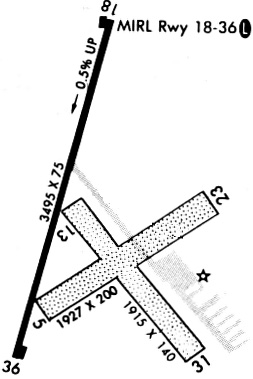
Runways
Runway Summary
| Runways: | 05/23 13/31 18/36 |
| Longest Runway: | 18/36 is 3498 ft (1066 m) long |
| Runways with an Instrument Approach: |
3JC Airport Runway Details
| Runway 05/23 | 1834 ft x 200 ft (559 m x 61 m) | |
| Runway Length Source: | 3RD PARTY SURVEY as of 12/01/2010 | |
| Surface: | Turf - Good condition - No special surface treatment | |
Runway 05 |
Runway 23 |
|
Elevation: |
1097.4 | 1088.1 |
Latitude: |
39-02-29.0349N | 39-02-39.0853N |
Longitude: |
096-50-41.5455W | 096-50-22.2056W |
|
Runway True Alignment: |
057 | 237 |
Glide Path Angle: |
0.0 degrees | 0.0 degrees |
Traffic Pattern: |
Left | Left |
Object at End: |
TREES | POLE |
Object Height: |
18 | 33 |
Distance from End: |
32 | 392 |
Object Centerline Offset: |
225 ft. right of centerline | 91 ft. left of centerline |
| Runway 13/31 | 1903 ft x 140 ft (580 m x 43 m) | |
| Runway Length Source: | 3RD PARTY SURVEY as of 12/01/2010 | |
| Surface: | Turf - Good condition - No special surface treatment | |
Runway 13 |
Runway 31 |
|
Elevation: |
1093.5 | 1094.1 |
Latitude: |
39-02-37.5343N | 39-02-23.1258N |
Longitude: |
096-50-39.0275W | 096-50-23.5288W |
|
Runway True Alignment: |
140 | 320 |
Glide Path Angle: |
0.0 degrees | 0.0 degrees |
Traffic Pattern: |
Left | Left |
Object at End: |
TREES | TREES |
Object Height: |
18 | 63 |
Distance from End: |
294 | 79 |
Object Centerline Offset: |
225 ft. right of centerline | 91 ft. left of centerline |
| Runway 18/36 | 3498 ft x 75 ft (1066 m x 23 m) | |
| Runway Length Source: | 3RD PARTY SURVEY as of 12/01/2010 | |
| Surface: | Turf - Good condition - No special surface treatment | |
| Runway Pavement Class: | 5 /F/C/Y/U | |
| Runway Edge Lights: | Medium Intensity | |
Runway Weight Bearing Capacity (in thousands of pounds) |
||
| Single Wheel Landing Gear: | 10.0 | |
Runway 18 |
Runway 36 |
|
Elevation: |
1086.2 | 1101.6 |
Latitude: |
39-02-56.8357N | 39-02-23.2412N |
Longitude: |
096-50-35.0879W | 096-50-45.5524W |
|
Runway True Alignment: |
194 | 014 |
Glide Path Angle: |
3.0 degrees | 3.5 degrees |
Traffic Pattern: |
Left | Left |
Runway Markings Type: |
Basic | Nonprecision Instrument |
Runway Markings Condition: |
Fair | Fair |
Object at End: |
POLE | POLE |
Object Height: |
35 | 68 |
Object Marked/Lighted?: |
Lighted | Lighted |
Distance from End: |
443 | 684 |
Object Centerline Offset: |
225 ft. right of centerline | 91 ft. left of centerline |
Visual Glide Slope Indicators: |
2-Light PAPI On Left Side Of Runway | 2-Light PAPI On Left Side Of Runway |
Threshold Crossing Height: |
43 | 43 |
Services
Airframe Repair: |
Minor |
Powerplant Repair: |
Minor |
Bottled Oxygen: |
None |
Bulk Oxygen: |
None |
Fuel Available: |
100LL, Jet A |
Landing Fees: |
No |
Parking: |
Hangars and tiedowns available |
Maps & Diagrams
3JC Sectional
Flight Planning
at skyvector.com
at skyvector.com