Location
Latitude: |
36-16-53.6850N (36.281579) |
Longitude: |
094-18-27.9560W (-94.307766) |
Elevation: |
1288.2 feet MSL (393 m MSL) |
Magnetic Variation: |
1.1 E (as of April 2024 from WMM2020 model) |
Time Zone: |
UTC -6.0 (Standard Time) UTC -5.0 (Daylight Savings Time) |
From City: |
15 N.M. NW of Fayetteville/Springdale/, Arkansas |
Found On: |
Kansas City Chart |
FAA Region: |
ASW |
Contacts
Manager: |
Publicly owned: |
| ANDREW BRANCH 1 AIRPORT BLVD, SUITE 100 BENTONVILLE, AR 72713 479-205-1000 |
NW ARKANSAS RGNL ARPT AUTH. 1 AIRPORT BLVD, SUITE 100 BENTONVILLE, AR 72713 479-205-1000 |
Operations
Airport Status: |
Operational |
Facility Use: |
Public |
Type: |
Airport |
Activation Date: |
04/1997 |
Control tower: |
Yes |
Attendance (Months/Days/Hours): |
Months/Days/Hours ALL/ALL/ALL |
Boundary ARTCC: |
ZME (Memphis) |
Responsible ARTCC: |
ZME (Memphis) |
Lighting Schedule: |
SEE RMK |
Segmented Circle Indicator: |
Yes |
Traffic Pattern Altitude (MSL): |
2288 feet (697 m) |
NOTAMs Facility: |
XNA |
NOTAM-D Service: |
Yes |
Aircraft Rescue and Firefighting: |
Class I ARFF Index: B Air Carrier Service: Scheduled Certification Date: 10/1998 |
Based Aircraft
| Single Engine: | 3 |
| Jet Engine: | 9 |
Annual Operations (as of 06/30/2023)
| Total Operations: | 46510 | |
| Commercial: | 22658 | 48.7% |
| Air Taxi: | 5753 | 12.4% |
| GA Local: | 506 | 1.1% |
| GA Itinerant: | 6044 | 13.0% |
| Military Aircraft: | 11549 | 24.8% |
Communications
| CTAF: | 127.100 |
| Tower: | NORTHWEST ARKANSAS NTL 127.1 Hrs: 0530-2300 |
| Ground: | 121.9 |
| Approach: | RAZORBACK MEMPHIS ARTCC |
| Departure: | RAZORBACK MEMPHIS ARTCC |
| ATIS: | 119.425 Hrs: 24 |
| ASOS: | 119.425 (479-203-0109) |
- ATCT OPERATED BY MIDWEST ATC SERVICES INC.
- APCH/DEP SVC PRVDD BY MEMPHIS ARTCC ON FREQS 126.1/269.0 (FAYETTEVILLE RCAG) WHEN RAZORBACK APCH CTL CLSD.
Fixed Based Operators (FBOs) & Fuel
(Click on a business for detail)
Please help us keep this information up to date. This is a FREE SERVICE just like everything else on Airport Guide! If you see that a business needs to be added, modified, or deleted please fill out our Update Form.
To add, modify, or delete a business click here.
Please help us keep this information up to date. This is a FREE SERVICE just like everything else on Airport Guide! If you see that a business needs to be added, modified, or deleted please fill out our Update Form.
Area Code: 501 |
| Business Name | Frequency | Phone | Fuel Grade |
|---|
Flight Service Stations
| Primary | Alternate | |
| FSS on Field: | N | |
| FSS Name (ID): | Jonesboro(JBR) | |
| Frequency: | ||
| Toll Free Phone: | 1-800-WX-BRIEF |
Instrument Procedures / Charts
FAA Terminal Procedures valid from 0901Z 03/21/24 to 0901Z 04/18/24.
There are various types of charts available for an airport. They are listed in the Page Type column. Here is a legend for those types:
APD - Airport Diagram
DP - Departure Procedure Charts
HOT - Hot Spots
IAP - Instrument Approach Procedure Charts
MIN - Minimums
STAR - Standard Terminal Arrival Charts
| Page Type | Page Name | Volume | Action Since Last Cycle |
|---|---|---|---|
| APD | AIRPORT DIAGRAM | SC-1 | |
| DP | HIGHFILL NINE | SC-1 | |
| IAP | ILS OR LOC RWY 16L | SC-1 | |
| IAP | ILS OR LOC RWY 34R | SC-1 | |
| IAP | RNAV (GPS) RWY 16L | SC-1 | |
| IAP | RNAV (GPS) RWY 34R | SC-1 | |
| MIN | ALTERNATE MINIMUMS | SC-1 | |
| MIN | TAKEOFF MINIMUMS | SC-1 |
Terminal Procedures are only available for airports in several countries with more being added all the time. If you are looking for a specific country's charts, please send an email to support(at)airportguide.com stating the country name. This will be used to prioritize the implementation.
Navigation Aids (Navaids) near XNA
| Dist (NM) | ID | Morse Code | Name | Type | Freq | True Hdg | Mag Hdg |
|---|---|---|---|---|---|---|---|
| 9.3 | RZC | . _ . _ _ . . _ . _ . | Razorback | VORTAC | 116.40 | 103 | 102 |
| 10.4 | SLG | . . . . _ . . _ _ . | Siloam Springs | NDB | 284 | 237 | 236 |
| 15.3 | DAK | _ . . . _ _ . _ | Drake | DME | 115.25 | 159 | 158 |
| 15.8 | RO | . _ . _ _ _ | Rogrs | NDB | 263 | 46 | 45 |
| 34.2 | EOS | . _ _ _ . . . | Neosho | DME | 117.3 | 349 | 348 |
| 40.0 | TQH | _ _ _ . _ . . . . | Tahlequah | NDB | 215 | 238 | 237 |
| 53.0 | HRO | . . . . . _ . _ _ _ | Harrison | VOR-DME | 112.50 | 87 | 86 |
| 53.6 | FSM | . . _ . . . . _ _ | Fort Smith | VORTAC | 110.40 | 178 | 177 |
| 55.8 | HR | . . . . . _ . | Bakky | NDB | 395 | 95 | 94 |
| 55.8 | FS | . . _ . . . . | Wizer | NDB | 223 | 175 | 174 |
| 56.6 | JL | . _ _ _ . _ . . | Lunns | NDB | 344 | 347 | 346 |
| 58.0 | IQS | . . _ _ . _ . . . | Sallisaw | NDB | 520 | 204 | 203 |
| 58.1 | GK | _ _ . _ . _ | Jembo | NDB | 311 | 188 | 187 |
| 65.0 | CZE | _ . _ . _ _ . . . | Clarksville | NDB | 201 | 138 | 137 |
| 68.0 | OSW | _ _ _ . . . . _ _ | Oswego | DME | 117.6 | 320 | 319 |
| 71.8 | TUL | _ . . _ . _ . . | Tulsa | VORTAC | 114.40 | 266 | 264 |
| 72.4 | LLU | . _ . . . _ . . . . _ | Spring River | NDB | 356 | 359 | 358 |
| 72.5 | PTS | . _ _ . _ . . . | Pittsburg | NDB | 365 | 344 | 343 |
| 76.4 | TUL | _ . . _ . _ . . | Tulsa Intl | VOT | 109.00 | 266 | 264 |
| 77.4 | TU | _ . . _ | Oillr | NDB | 338 | 262 | 260 |
Nearby Airports with Fuel
Notices to Airmen (NOTAMS)
Remarks
| A110-3 | BIRD ACTIVITY ON & INVOF ARPT. |
| A110-4 | CTN ELEVATED RWY THLD LGTS AER RWYS 16L & 34R. |
| A110-5 | FOR CD CTC MEMPHIS ARTCC AT 901-368-8453/8449. |
| A3 | DSTC & DIRECTION TO ARPT FM SPRINGDALE IS 10 NM NW & FM ROGERS MSA IS 9 NM SW. |
| A70-FUEL-10 | 0LL FOR FUEL SERVICES USE FREQ 130.05. |
| A81-APT | WHEN ATCT CLSD ACTVT MALSR RWY 16L&34R; HIRL RWY 16L/34R - CTAF. PAPI RWY 16L & 34R OPER CONSLY. |
| E111 | SEE AIRSPACE LTR DATED 2/26/97. |
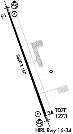
Runways
Runway Summary
| Runways: | 16L/34R 16R/34L |
| Longest Runway: | 16L/34R is 8801 ft (2683 m) long |
| Runways with an Instrument Approach: | 16L, 34R, 16R, 34L |
XNA Airport Runway Details
| Runway 16L/34R | 8801 ft x 150 ft (2683 m x 46 m) | |
| Runway Length Source: | 3RD PARTY SURVEY as of 03/23/2011 | |
| Surface: | Concrete - Good condition - Saw-cut or plastic grooved | |
| Runway Pavement Class: | 68 /R/B/W/T | |
| Runway Edge Lights: | High Intensity | |
Runway Weight Bearing Capacity (in thousands of pounds) |
||
| Single Wheel Landing Gear: | 120.0 | |
| Dual Wheel Landing Gear: | 223.0 | |
| Dual Tandem Wheel Landing Gear: | 404.0 | |
Runway 16L |
Runway 34R |
|
Elevation: |
1287.0 | 1264.6 |
Latitude: |
36-17-35.5278N | 36-16-13.8959N |
Longitude: |
094-18-43.1360W | 094-18-05.9068W |
|
Runway True Alignment: |
160 | 340 |
ILS Type: |
ILS/DME | ILS/DME |
Glide Path Angle: |
3.0 degrees | 3.0 degrees |
Runway Markings Type: |
Precision Instrument | Precision Instrument |
Runway Markings Condition: |
Good | Good |
Visual Glide Slope Indicators: |
4-Light PAPI On Left Side Of Runway | 4-Light PAPI On Left Side Of Runway |
Runway Visual Range (RVR): |
Touchdown, Rollout | Touchdown, Rollout |
Approach Light System: |
1,400 Foot Medium Intensity Approach Lighting System With Runway Alignment Indicator Lights | 1,400 Foot Medium Intensity Approach Lighting System With Runway Alignment Indicator Lights |
Threshold Crossing Height: |
52 | 51 |
Declared Distances |
||
Take Off Run Avbl. (TORA): |
8800 | 8800 |
Take Off Distance Avbl. (TODA): |
8800 | 8800 |
Actual Stop Dist. Avbl. (ASDA): |
8800 | 8800 |
Landing Dist. Avbl. (LDA): |
8800 | 8800 |
| Runway 16R/34L | 8800 ft x 150 ft (2682 m x 46 m) | |
| Runway Length Source: | 3RD PARTY SURVEY as of 01/30/2009 | |
| Surface: | Concrete - Good condition - Saw-cut or plastic grooved | |
| Runway Edge Lights: | Medium Intensity | |
Runway Weight Bearing Capacity (in thousands of pounds) |
||
| Single Wheel Landing Gear: | 75.0 | |
| Dual Wheel Landing Gear: | 150.0 | |
| Dual Tandem Wheel Landing Gear: | 350.0 | |
Runway 16R |
Runway 34L |
|
Elevation: |
1288.2 | 1265.3 |
Latitude: |
36-17-33.4720N | 36-16-11.8413N |
Longitude: |
094-18-50.0118W | 094-18-12.7796W |
|
Runway True Alignment: |
160 | 340 |
ILS Type: |
ILS/DME | ILS/DME |
Glide Path Angle: |
0.0 degrees | 0.0 degrees |
Runway Markings Type: |
Precision Instrument | Precision Instrument |
Runway Markings Condition: |
Good | Good |
Declared Distances |
||
Take Off Run Avbl. (TORA): |
8800 | 8800 |
Take Off Distance Avbl. (TODA): |
8800 | 8800 |
Actual Stop Dist. Avbl. (ASDA): |
8800 | 8800 |
Landing Dist. Avbl. (LDA): |
8800 | 8800 |
Services
Airframe Repair: |
Minor |
Powerplant Repair: |
Minor |
Bottled Oxygen: |
None |
Fuel Available: |
100LL, Jet A+ |
Landing Fees: |
No |
Parking: |
Hangars and tiedowns available |
Maps & Diagrams
XNA Sectional
Flight Planning
at skyvector.com
at skyvector.com