Location
Latitude: |
43-02-27.7000N (43.041028) |
Longitude: |
088-14-13.4000W (-88.237056) |
Elevation: |
911.5 feet MSL (278 m MSL) |
Magnetic Variation: |
3.8 W (as of April 2024 from WMM2020 model) |
Time Zone: |
UTC -6.0 (Standard Time) UTC -5.0 (Daylight Savings Time) |
From City: |
02 N.M. N of Waukesha, Wisconsin |
Found On: |
Chicago Chart |
FAA Region: |
AGL |
Contacts
Manager: |
Publicly owned: |
| KURT STANICH 2525 AVIATION DR WAUKESHA, WI 53188 262-521-5250 |
WAUKESHA COUNTY 515 W MOORLAND BLVD WAUKESHA, WI 53188 262-548-7010 |
Operations
Airport Status: |
Operational |
Facility Use: |
Public |
Type: |
Airport |
Activation Date: |
09/1937 |
Control tower: |
Yes |
Attendance (Months/Days/Hours): |
Months/Days/Hours ALL/ALL/ALL |
Boundary ARTCC: |
ZAU (Chicago) |
Responsible ARTCC: |
ZAU (Chicago) |
Lighting Schedule: |
SEE RMK |
Segmented Circle Indicator: |
Yes |
Traffic Pattern Altitude (MSL): |
1912 feet (583 m) |
NOTAMs Facility: |
UES |
NOTAM-D Service: |
Yes |
International Airport of Entry: |
No |
Customs Landing Rights: |
No |
Military Landing Rights: |
Yes |
Civil/Military Joint Use: |
No |
Based Aircraft
| Single Engine: | 163 |
| Multi Engine: | 18 |
| Jet Engine: | 24 |
| GA Helicopters: | 5 |
| Gliders: | 2 |
Annual Operations (as of 04/30/2021)
| Total Operations: | 61471 | |
| Commercial: | 3 | 0.0% |
| Air Taxi: | 3263 | 5.3% |
| GA Local: | 29399 | 47.8% |
| GA Itinerant: | 28526 | 46.4% |
| Military Aircraft: | 280 | 0.5% |
Communications
| CTAF: | 123.700 |
| Unicom: | 122.950 |
| Tower: | WAUKESHA 123.7 Hrs: 0600-2100 |
| Clearance Del.: | 121.6 |
| Ground: | 121.6 |
| Approach: | MILWAUKEE 125.35 125.35 125.35 125.35 125.35 |
| Departure: | MILWAUKEE 125.35 125.35 125.35 125.35 125.35 |
| ATIS: | 118.875 Hrs: 24 |
| AWOS-3: | 118.875 (262-521-5226) |
| AR OPS: | 38.3 |
Fixed Based Operators (FBOs) & Fuel
(Click on a business for detail)
Please help us keep this information up to date. This is a FREE SERVICE just like everything else on Airport Guide! If you see that a business needs to be added, modified, or deleted please fill out our Update Form.
To add, modify, or delete a business click here.
Please help us keep this information up to date. This is a FREE SERVICE just like everything else on Airport Guide! If you see that a business needs to be added, modified, or deleted please fill out our Update Form.
Area Code: 262 |
| Business Name | Frequency | Phone | Fuel Grade |
|---|---|---|---|
| Waukesha Flying Services
Update FBO info |
Unicom 122.95 | 549-6150 | 100LL, Jet A |
Flight Service Stations
| Primary | Alternate | |
| FSS on Field: | N | |
| FSS Name (ID): | Green Bay(GRB) | |
| Frequency: | ||
| Toll Free Phone: | 1-800-WX-BRIEF |
Instrument Procedures / Charts
FAA Terminal Procedures valid from 0901Z 03/21/24 to 0901Z 04/18/24.
There are various types of charts available for an airport. They are listed in the Page Type column. Here is a legend for those types:
APD - Airport Diagram
DP - Departure Procedure Charts
HOT - Hot Spots
IAP - Instrument Approach Procedure Charts
MIN - Minimums
STAR - Standard Terminal Arrival Charts
| Page Type | Page Name | Volume | Action Since Last Cycle |
|---|---|---|---|
| APD | AIRPORT DIAGRAM | EC-3 | Changed |
| DP | ACCRA FIVE (RNAV) | EC-3 | |
| DP | UECKR SIX (RNAV) | EC-3 | |
| IAP | ILS OR LOC RWY 10 | EC-3 | |
| IAP | RNAV (GPS) RWY 10 | EC-3 | |
| IAP | RNAV (GPS) RWY 28 | EC-3 | Changed |
| IAP | VOR-A | EC-3 | |
| MIN | ALTERNATE MINIMUMS | EC-3 | |
| MIN | TAKEOFF MINIMUMS | EC-3 | |
| STAR | GOPAC THREE (RNAV) | EC-3 |
Terminal Procedures are only available for airports in several countries with more being added all the time. If you are looking for a specific country's charts, please send an email to support(at)airportguide.com stating the country name. This will be used to prioritize the implementation.
Navigation Aids (Navaids) near UES
| Dist (NM) | ID | Morse Code | Name | Type | Freq | True Hdg | Mag Hdg |
|---|---|---|---|---|---|---|---|
| 5.0 | BAE | _ . . . . _ . | Badger | VOR-DME | 116.40 | 335 | 339 |
| 9.7 | LJT | . _ . . . _ _ _ _ | Timmerman | DME | 115.65 | 64 | 68 |
| 11.7 | GM | _ _ . _ _ | Teels | NDB | 242 | 132 | 136 |
| 15.8 | BL | _ . . . . _ . . | Yanks | NDB | 260 | 85 | 89 |
| 16.0 | MKE | _ _ _ . _ . | Milwaukee | VOT | 109.00 | 110 | 114 |
| 21.3 | BUU | _ . . . . . _ . . _ | Burbun | DME | 114.5 | 187 | 191 |
| 22.8 | RYV | . _ . _ . _ _ . . . _ | Rock River | NDB | 371 | 290 | 294 |
| 23.4 | BJB | _ . . . . _ _ _ _ . . . | West Bend | VOR | 109.80 | 12 | 16 |
| 25.0 | HRK | . . . . . _ . _ . _ | Horlick | DME | 114.05 | 131 | 135 |
| 25.8 | LVV | . _ . . . . . _ . . . _ | Lake Lawn | NDB | 404 | 217 | 221 |
| 26.1 | RA | . _ . . _ | Paser | NDB | 206 | 145 | 149 |
| 29.7 | ENW | . _ . . _ _ | Kenosha | DME | 109.2 | 153 | 157 |
| 30.3 | EN | . _ . | Codee | NDB | 389 | 162 | 166 |
| 30.9 | UNU | . . _ _ . . . _ | Juneau | NDB | 344 | 319 | 323 |
| 39.6 | UG | . . _ _ _ . | Wauke | NDB | 379 | 150 | 154 |
| 43.7 | JVL | . _ _ _ . . . _ . _ . . | Janesville | NDB | 375 | 234 | 238 |
| 46.8 | FAH | . . _ . . _ . . . . | Falls | DME | 110 | 21 | 25 |
| 48.0 | JVL | . _ _ _ . . . _ . _ . . | Janesville | VOR-DME | 114.30 | 233 | 236 |
| 48.6 | MS | _ _ . . . | Monah | NDB | 400 | 271 | 274 |
| 48.7 | MSN | _ _ . . . _ . | Madison | VORTAC | 108.60 | 277 | 280 |
Nearby Airports with Fuel
Notices to Airmen (NOTAMS)
Remarks
| A110-1 | COYOTES ON & INVOF ARPT. |
| A110-2 | NORTH RAMP LIGHTS OUT OF SERVICE |
| A110-3 | CALL MILWAUKEE (MKE) CLEARENCE DELIVERY 128.7 'ONLY' WHEN WAUKESHA (UES) TWR CLSD. |
| A15 | EMAIL ADDRESS: KSTANICH@WAUKESHACOUNTY.GOV (ALL LOWER CASE) |
| A16 | CELL PHONE: 262-424-6747 |
| A36-10/28 | GROSS WT 2S-155 |
| A74 | CALL 262-549-6150 FOR OXY AVBLY. |
| A81-APT | HIRL RY 10/28 PRESET ON LOW INTST; TO INCR INTST & ACTVT MIRL RY 18/36 & REIL RYS 28 & 18/36; MALSR RY 10 - CTAF. |
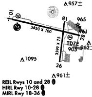
Runways
Runway Summary
| Runways: | 10/28 18/36 |
| Longest Runway: | 10/28 is 5849 ft (1783 m) long |
| Runways with an Instrument Approach: | 10 |
UES Airport Runway Details
| Runway 10/28 | 5849 ft x 100 ft (1783 m x 30 m) | |
| Runway Length Source: | 3RD PARTY SURVEY as of 11/13/2010 | |
| Surface: | Concrete - Excellent condition - Saw-cut or plastic grooved | |
| Runway Edge Lights: | High Intensity | |
Runway Weight Bearing Capacity (in thousands of pounds) |
||
| Single Wheel Landing Gear: | 60.0 | |
| Dual Wheel Landing Gear: | 100.0 | |
Runway 10 |
Runway 28 |
|
Elevation: |
897.2 | 906.1 |
Latitude: |
43-02-38.2047N | 43-02-26.2320N |
Longitude: |
088-14-58.9753W | 088-13-41.9291W |
|
Runway True Alignment: |
102 | 282 |
ILS Type: |
ILS | |
Glide Path Angle: |
3.0 degrees | 3.8 degrees |
Traffic Pattern: |
Left | Right |
Runway Markings Type: |
Precision Instrument | Precision Instrument |
Runway Markings Condition: |
Good | Good |
Object at End: |
TREES | TREES |
Object Height: |
243 | 80 |
Distance from End: |
8930 | 1590 |
Object Centerline Offset: |
1100 ft. right of centerline | 100 ft. left of centerline |
Visual Glide Slope Indicators: |
4-Light PAPI On Right Side Of Runway | 4-Box VASI On Left Side Of Runway |
Approach Light System: |
1,400 Foot Medium Intensity Approach Lighting System With Runway Alignment Indicator Lights | |
REIL: |
No | Yes |
Threshold Crossing Height: |
53 | 37 |
| Runway 18/36 | 3599 ft x 75 ft (1097 m x 23 m) | |
| Runway Length Source: | 3RD PARTY SURVEY as of 11/13/2010 | |
| Surface: | Concrete - Excellent condition - No special surface treatment | |
| Runway Edge Lights: | Medium Intensity | |
Runway Weight Bearing Capacity (in thousands of pounds) |
||
| Single Wheel Landing Gear: | 20.0 | |
Runway 18 |
Runway 36 |
|
Elevation: |
906.3 | 911.5 |
Latitude: |
43-02-38.0116N | 43-02-02.6111N |
Longitude: |
088-13-59.6035W | 088-14-04.0253W |
|
Runway True Alignment: |
185 | 005 |
Glide Path Angle: |
3.0 degrees | 4.0 degrees |
Traffic Pattern: |
Right | |
Runway Markings Type: |
Nonprecision Instrument | Nonprecision Instrument |
Runway Markings Condition: |
Fair | Fair |
Object at End: |
TREE | |
Object Height: |
39 | |
Distance from End: |
750 | |
Object Centerline Offset: |
1100 ft. right of centerline | 100 ft. left of centerline |
Visual Glide Slope Indicators: |
2-Light PAPI On Left Side Of Runway | 2-Light PAPI On Left Side Of Runway |
REIL: |
Yes | Yes |
Threshold Crossing Height: |
27 | 26 |
Services
Airframe Repair: |
Major |
Powerplant Repair: |
Major |
Bottled Oxygen: |
None |
Bulk Oxygen: |
None |
Fuel Available: |
100LL |
Landing Fees: |
No |
Parking: |
Hangars and tiedowns available |
Maps & Diagrams
UES Sectional
Flight Planning
at skyvector.com
at skyvector.com