Location
Latitude: |
43-18-31.7000N (43.308806) |
Longitude: |
113-56-09.7000W (-113.936028) |
Elevation: |
4789.0 feet MSL (1460 m MSL) |
Magnetic Variation: |
12.1 E (as of April 2024 from WMM2020 model) |
Time Zone: |
UTC -7.0 (Standard Time) UTC -6.0 (Daylight Savings Time) |
From City: |
00 N.M. E of Carey, Idaho |
Found On: |
Salt Lake City Chart |
FAA Region: |
ANM |
Contacts
Manager: |
Publicly owned: |
| JOSH PRITCHARD 20 EL PINO CAREY, ID 83320 208-721-2965 |
CITY OF CAREY BOX 6 CAREY, ID 83320 208-823-4045 |
Operations
Airport Status: |
Operational |
Facility Use: |
Public |
Type: |
Airport |
Activation Date: |
08/1955 |
Control tower: |
No |
Attendance (Months/Days/Hours): |
Months/Days/Hours Unattended |
Boundary ARTCC: |
ZLC (Salt Lake City) |
Responsible ARTCC: |
ZLC (Salt Lake City) |
Segmented Circle Indicator: |
Yes |
Traffic Pattern Altitude (MSL): |
5789 feet (1764 m) |
NOTAMs Facility: |
BOI |
NOTAM-D Service: |
Yes |
International Airport of Entry: |
No |
Customs Landing Rights: |
No |
Military Landing Rights: |
No |
Civil/Military Joint Use: |
No |
Based Aircraft
| Single Engine: | 6 |
Annual Operations (as of 08/30/2023)
| Total Operations: | 3000 | |
| GA Local: | 1500 | 50.0% |
| GA Itinerant: | 1500 | 50.0% |
Communications
| CTAF: | 122.900 |
Fixed Based Operators (FBOs) & Fuel
(Click on a business for detail)
Please help us keep this information up to date. This is a FREE SERVICE just like everything else on Airport Guide! If you see that a business needs to be added, modified, or deleted please fill out our Update Form.
To add, modify, or delete a business click here.
Please help us keep this information up to date. This is a FREE SERVICE just like everything else on Airport Guide! If you see that a business needs to be added, modified, or deleted please fill out our Update Form.
Area Code: 208 |
| Business Name | Frequency | Phone | Fuel Grade |
|---|
Flight Service Stations
| Primary | Alternate | |
| FSS on Field: | N | |
| FSS Name (ID): | Boise(BOI) | |
| Frequency: | ||
| Toll Free Phone: | 1-800-WX-BRIEF |
Instrument Procedures / Charts
Terminal Procedures are only available for airports in several countries with more being added all the time. If you are looking for a specific country's charts, please send an email to support(at)airportguide.com stating the country name. This will be used to prioritize the implementation.
Navigation Aids (Navaids) near U65
| Dist (NM) | ID | Morse Code | Name | Type | Freq | True Hdg | Mag Hdg |
|---|---|---|---|---|---|---|---|
| 13.5 | HLE | . . . . . _ . . . | Hailey | NDB-DME | 220 | 275 | 263 |
| 40.0 | HDG | . . . . _ . . _ _ . | Steelhead | NDB | 211 | 234 | 222 |
| 43.8 | BYI | _ . . . _ . _ _ . . | Burley | VOR-DME | 114.10 | 175 | 163 |
| 53.1 | TW | _ . _ _ | Strik | NDB | 389 | 200 | 188 |
| 55.4 | TWF | _ . _ _ . . _ . | Twin Falls | VORTAC | 113.10 | 206 | 194 |
| 62.1 | PIH | . _ _ . . . . . . . | Pocatello | VOR-DME | 112.60 | 114 | 102 |
| 65.5 | PI | . _ _ . . . | Tyhee | NDB | 383 | 107 | 95 |
| 76.2 | STI | . . . _ . . | Sturgeon | NDB | 333 | 261 | 249 |
| 77.7 | SWU | . . . . _ _ . . _ | Sweden | NDB | 350 | 83 | 71 |
| 82.6 | IDA | . . _ . . . _ | Idaho Falls | VOR-DME | 113.85 | 80 | 68 |
| 82.8 | LIA | . _ . . . . . _ | Liberator | VOR | 114.90 | 256 | 244 |
| 86.3 | MUO | _ _ . . _ _ _ _ | Mountain Home | TACAN | 114.00 | 259 | 247 |
| 86.9 | ID | . . _ . . | Uconn | NDB | 324 | 77 | 65 |
| 88.3 | DBS | _ . . _ . . . . . . | Dubois | VORTAC | 116.90 | 57 | 45 |
| 93.3 | MLD | _ _ . _ . . _ . . | Malad City | VOR-DME | 117.40 | 134 | 122 |
| 99.4 | BOI | _ . . . _ _ _ . . | Boise | VORTAC | 113.30 | 279 | 267 |
Nearby Airports with Fuel
Notices to Airmen (NOTAMS)
Remarks
| A110-1 | RECOMMEND LAND RWY 26; TKOF RWY 8 WHEN WND CONDITIONS PERMIT. |
| A110-2 | 30 FT HNGR & NMRS 30 TO 80 FT TREES AT 900 FT TO 1200 FT FM EOR 08. |
| A110-3 | BE ALERT FOR SPRINKLERS ON RY. |
| A110-4 | FOR CD CTC SALT LAKE ARTCC AT 801-320-2568. |
| A42-08 | 08/26 EDGES & THRS MKD WITH CONCRETE MARKERS. |
| A57-08 | A 6 FT CHAIN LINK FENCE HAS BEEN INSTLD ON THE SOUTH SIDE OF RWY AT 0 FT, 100 FT RIGHT - BTN THE TIE-DOWN AREA AND THE AG FLD ADJ TO IT. |
| A84 | FULL CRC, NON-STD ON BOTH WINDSOCKS. |
| E111 | ESTABD PRIOR TO 1959. |
Runways
Runway Summary
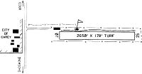
| Runways: | 08/26 |
| Longest Runway: | 08/26 is 2650 ft (808 m) long |
| Runways with an Instrument Approach: |
U65 Airport Runway Details
| Runway 08/26 | 2650 ft x 170 ft (808 m x 52 m) | |
| Surface: | Turf - Good condition - No special surface treatment | |
Runway 08 |
Runway 26 |
|
Elevation: |
4789.0 | 4780.0 |
Latitude: |
43-18-31.7600N | 43-18-31.6100N |
Longitude: |
113-56-27.5900W | 113-55-51.7400W |
|
Runway True Alignment: |
090 | 270 |
Glide Path Angle: |
0.0 degrees | 0.0 degrees |
Traffic Pattern: |
Left | Left |
Object at End: |
FENCE | FENCE |
Object Height: |
6 | 4 |
Distance from End: |
0 | 25 |
Object Centerline Offset: |
100 ft. right of centerline | 0 ft. left and right of centerline |
Services
Airframe Repair: |
None |
Powerplant Repair: |
None |
Bottled Oxygen: |
None |
Bulk Oxygen: |
None |
Fuel Available: |
100LL |
Landing Fees: |
No |
Parking: |
Tiedowns available |
Maps & Diagrams
U65 Sectional
Flight Planning
at skyvector.com
at skyvector.com