Location
Latitude: |
56-34-38.5000N (56.577361) |
Longitude: |
169-39-49.4000W (-169.663722) |
Elevation: |
127.9 feet MSL (39 m MSL) |
Magnetic Variation: |
6.4 E (as of April 2024 from WMM2020 model) |
Time Zone: |
UTC -10.0 (Standard Time) UTC -9.0 (Daylight Savings Time) |
From City: |
04 N.M. SW of St. George, Alaska |
Found On: |
Dutch Harbor Chart |
FAA Region: |
AAL |
Contacts
Manager: |
Publicly owned: |
| DALE RUCKMAN PO BOX 920525 DUTCH HARBOR, AK 99692 (907) 581-1786 |
ALASKA DOT&PF SOUTHCOAST REGION PO BOX 112506 JUNEAU, AK 99811-2506 (907) 465-1779 |
Operations
Airport Status: |
Operational |
Facility Use: |
Public |
Type: |
Airport |
Activation Date: |
07/1992 |
Control tower: |
No |
Attendance (Months/Days/Hours): |
Months/Days/Hours Unattended |
Boundary ARTCC: |
ZAN (Anchorage) |
Responsible ARTCC: |
ZAP (Anchorage Oceanic) |
Lighting Schedule: |
SEE RMK |
Segmented Circle Indicator: |
Yes |
Traffic Pattern Altitude (MSL): |
1128 feet (344 m) |
NOTAMs Facility: |
PBV |
NOTAM-D Service: |
Yes |
Military Landing Rights: |
Yes |
Based Aircraft
Annual Operations (as of 12/31/2022)
| Total Operations: | 156 | |
| Commercial: | 156 | 100.0% |
Communications
| CTAF: | 122.800 |
| ASOS: | 135.45 (907-859-2700) |
- APCH/DEP SVC PRVDD BY ANCHORAGE ARTCC ON FREQS 119.1/339.8 (SAINT PAUL ISLAND RCAG).
Fixed Based Operators (FBOs) & Fuel
(Click on a business for detail)
Please help us keep this information up to date. This is a FREE SERVICE just like everything else on Airport Guide! If you see that a business needs to be added, modified, or deleted please fill out our Update Form.
To add, modify, or delete a business click here.
Please help us keep this information up to date. This is a FREE SERVICE just like everything else on Airport Guide! If you see that a business needs to be added, modified, or deleted please fill out our Update Form.
Area Code: 907 |
| Business Name | Frequency | Phone | Fuel Grade |
|---|
Flight Service Stations
| Primary | Alternate | |
| FSS on Field: | ||
| FSS Name (ID): | Kenai(ENA) | |
| Frequency: | ||
| Toll Free Phone: | 1-866-864-1737 |
Instrument Procedures / Charts
FAA Terminal Procedures valid from 0901Z 03/21/24 to 0901Z 04/18/24.
There are various types of charts available for an airport. They are listed in the Page Type column. Here is a legend for those types:
APD - Airport Diagram
DP - Departure Procedure Charts
HOT - Hot Spots
IAP - Instrument Approach Procedure Charts
MIN - Minimums
STAR - Standard Terminal Arrival Charts
| Page Type | Page Name | Volume | Action Since Last Cycle |
|---|---|---|---|
| IAP | ILS OR LOC RWY 11 | AK-1 | |
| IAP | RNAV (GPS) RWY 11 | AK-1 | |
| IAP | RNAV (GPS)-D | AK-1 | Changed |
| MIN | ALTERNATE MINIMUMS | AK-1 | |
| MIN | TAKEOFF MINIMUMS | AK-1 |
Terminal Procedures are only available for airports in several countries with more being added all the time. If you are looking for a specific country's charts, please send an email to support(at)airportguide.com stating the country name. This will be used to prioritize the implementation.
Navigation Aids (Navaids) near STG
Nearby Airports with Fuel
| Dist (NM) | Name (Airport IDs) | True Hdg | Mag Hdg | Fuel Grade |
|---|
Notices to Airmen (NOTAMS)
Remarks
| A110-1 | LARGE CONCENTRATIONS OF SEABIRDS INVOF ARPT. REINDEER AND FOX INVOF ARPT. |
| A110-2 | PILOTS ARE REQUESTED TO AVOID FLIGHTS BELOW 1000 FT AGL FROM MAY 14 THROUGH DEC 14 IN THOSE AREAS OF ST. GEORGE ISLAND WITH ACTIVE BIRD POPULATIONS AND COASTAL SEAL ROOKERIES. |
| A57-11 | CONTROLLING OBSTRUCTION EXCEEDS A 45 DEGREE SLOPE |
| A58-11 | ROAD BEGINNING AT EDGES OF THE END OF RWY EXTENDING OUT TO 200 FT MERGING APPX ON CENTERLINE. |
| A58-29 | ROAD BEGINNING AT RIGHT EDGE AND END OF RWY AND EXTENDS OUT TO 200 FT APPX PARALLEL TO RWY CENTERLINE. |
| A81-APT | ACTVT HIRL RY 11/29, REIL RY 29; MALSF & PAPI RY 11, & WINDSOCK - CTAF. |
| A81-BCN | ACTVT ROTG BCN - CTAF. |
Runways
Runway Summary
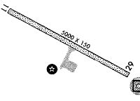
| Runways: | 11/29 |
| Longest Runway: | 11/29 is 4982 ft (1519 m) long |
| Runways with an Instrument Approach: | 11 |
STG Airport Runway Details
| Runway 11/29 | 4982 ft x 150 ft (1519 m x 46 m) | |
| Runway Length Source: | 3RD PARTY SURVEY as of 06/09/2012 | |
| Surface: | Asphalt - Good condition - Saw-cut or plastic grooved | |
| Runway Edge Lights: | High Intensity | |
Runway 11 |
Runway 29 |
|
Elevation: |
127.9 | 123.4 |
Latitude: |
56-34-50.0925N | 56-34-26.8341N |
Longitude: |
169-40-28.6052W | 169-39-10.2819W |
|
Runway True Alignment: |
118 | 298 |
ILS Type: |
LOC/GS | |
Glide Path Angle: |
3.6 degrees | 0.0 degrees |
Traffic Pattern: |
Right | |
Runway Markings Type: |
Precision Instrument | Precision Instrument |
Runway Markings Condition: |
Fair | Fair |
Object at End: |
ROAD | HILL |
Object Height: |
15 | 35 |
Distance from End: |
200 | 200 |
Object Centerline Offset: |
0 ft. left and right of centerline | 250 ft. right of centerline |
Visual Glide Slope Indicators: |
4-Light PAPI On Left Side Of Runway | |
Approach Light System: |
1,400 Foot Medium Intensity Approach Lighting System With Sequenced Flashers | |
REIL: |
Yes | |
Threshold Crossing Height: |
56 |
Services
Maps & Diagrams
STG Sectional
Flight Planning
at skyvector.com
at skyvector.com