Location
Latitude: |
27-45-54.4110N (27.765114) |
Longitude: |
082-37-36.9830W (-82.62694) |
Elevation: |
6.6 feet MSL (2 m MSL) |
Magnetic Variation: |
6 W (as of April 2024 from WMM2020 model) |
Time Zone: |
UTC -5.0 (Standard Time) UTC -4.0 (Daylight Savings Time) |
From City: |
00 N.M. E of St. Petersburg, Florida |
Found On: |
Miami Chart |
FAA Region: |
ASO |
Contacts
Manager: |
Publicly owned: |
| RICH LESNIAK ALBERT WHITTED AIRPORT, 107 8TH AVENUE SOUTHEAST ST PETERSBURG, FL 33701 727-893-7657 |
CITY OF ST PETERSBURG 107 8TH AVENUE, S.E. ST PETERSBURG, FL 33701 727-893-7654 |
Operations
Airport Status: |
Operational |
Facility Use: |
Public |
Type: |
Airport |
Activation Date: |
04/1940 |
Control tower: |
Yes |
Attendance (Months/Days/Hours): |
Months/Days/Hours ALL/ALL/0700-2100 |
Boundary ARTCC: |
ZMA (Miami) |
Responsible ARTCC: |
ZMA (Miami) |
Lighting Schedule: |
SEE RMK |
Segmented Circle Indicator: |
Yes |
Traffic Pattern Altitude (MSL): |
1007 feet (307 m) |
NOTAMs Facility: |
SPG |
NOTAM-D Service: |
Yes |
International Airport of Entry: |
No |
Customs Landing Rights: |
No |
Military Landing Rights: |
Yes |
Civil/Military Joint Use: |
No |
Based Aircraft
| Single Engine: | 158 |
| Multi Engine: | 26 |
| Jet Engine: | 2 |
| GA Helicopters: | 7 |
| Ultralights: | 1 |
Annual Operations (as of 09/30/2022)
| Total Operations: | 96369 | |
| Air Taxi: | 1941 | 2.0% |
| GA Local: | 48250 | 50.1% |
| GA Itinerant: | 45956 | 47.7% |
| Military Aircraft: | 222 | 0.2% |
Communications
| CTAF: | 127.400 |
| Unicom: | 122.950 |
| Tower: | WHITTED 127.4 257.6 Hrs: 0700-2100 |
| Ground: | 121.8 |
| Approach: | TAMPA 119.65 ;EAST 119.65 ;EAST 119.65 ;EAST |
| Departure: | TAMPA 119.65 ;EAST 119.65 ;EAST 119.65 ;EAST |
| ASOS: | 118.875 (727-821-4334) |
- FREQ 121.5 NOT MONITORED.
Fixed Based Operators (FBOs) & Fuel
(Click on a business for detail)
Please help us keep this information up to date. This is a FREE SERVICE just like everything else on Airport Guide! If you see that a business needs to be added, modified, or deleted please fill out our Update Form.
To add, modify, or delete a business click here.
Please help us keep this information up to date. This is a FREE SERVICE just like everything else on Airport Guide! If you see that a business needs to be added, modified, or deleted please fill out our Update Form.
Area Code: 727 |
| Business Name | Frequency | Phone | Fuel Grade |
|---|---|---|---|
| Albert Whitted Flying Club
Website Update FBO info |
898-6070 | ||
| Bay Air Flying Service, Inc.
Website Update FBO info |
Unicom 122.95 | 822-4216 | 100LL, Jet A |
| West Florida Helicopters, Inc.
Update FBO info |
Unicom 123.05 | 823-5200, 823-8683 | Jet A |
Flight Service Stations
| Primary | Alternate | |
| FSS on Field: | N | |
| FSS Name (ID): | Saint Petersburg(PIE) | |
| Frequency: | ||
| Toll Free Phone: | 1-800-WX-BRIEF |
Instrument Procedures / Charts
FAA Terminal Procedures valid from 0901Z 03/21/24 to 0901Z 04/18/24.
There are various types of charts available for an airport. They are listed in the Page Type column. Here is a legend for those types:
APD - Airport Diagram
DP - Departure Procedure Charts
HOT - Hot Spots
IAP - Instrument Approach Procedure Charts
MIN - Minimums
STAR - Standard Terminal Arrival Charts
| Page Type | Page Name | Volume | Action Since Last Cycle |
|---|---|---|---|
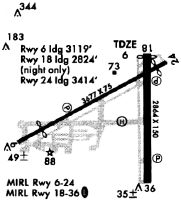
| APD | AIRPORT DIAGRAM | SE-3 | |
| IAP | RNAV (GPS) RWY 07 | SE-3 | |
| IAP | RNAV (GPS) RWY 18 | SE-3 | |
| IAP | RNAV (GPS) RWY 36 | SE-3 | |
| IAP | VOR RWY 18 | SE-3 | |
| MIN | ALTERNATE MINIMUMS | SE-3 | |
| MIN | TAKEOFF MINIMUMS | SE-3 | |
| STAR | BRDGE NINE | SE-3 | Changed |
Terminal Procedures are only available for airports in several countries with more being added all the time. If you are looking for a specific country's charts, please send an email to support(at)airportguide.com stating the country name. This will be used to prioritize the implementation.
Navigation Aids (Navaids) near SPG
| Dist (NM) | ID | Morse Code | Name | Type | Freq | True Hdg | Mag Hdg |
|---|---|---|---|---|---|---|---|
| 7.2 | AM | . _ _ _ | Picny | NDB | 388 | 36 | 42 |
| 8.3 | MCF | _ _ _ . _ . . . _ . | Macdill | TACAN | 111.00 | 46 | 52 |
| 9.1 | PIE | . _ _ . . . . | St Petersburg | VORTAC | 116.40 | 340 | 346 |
| 13.5 | TPA | _ . _ _ . . _ | Tampa Intl | VOT | 111.00 | 21 | 27 |
| 14.4 | PI | . _ _ . . . | Capok | NDB | 360 | 343 | 349 |
| 20.0 | TP | _ . _ _ . | Cosme | NDB | 368 | 15 | 21 |
| 21.7 | SRQ | . . . . _ . _ _ . _ | Sarasota | VOR-DME | 117.00 | 171 | 177 |
| 35.1 | LAL | . _ . . . _ . _ . . | Lakeland | VORTAC | 116.00 | 67 | 73 |
| 37.3 | RHZ | . _ . . . . . _ _ . . | Zephyrhills | NDB | 253 | 41 | 47 |
| 43.5 | VNC | . . . _ _ . _ . _ . | Venice | NDB | 206 | 166 | 172 |
| 61.1 | PGD | . _ _ . _ _ . _ . . | Punta Gorda | VOR | 110.20 | 146 | 152 |
| 76.6 | LEE | . _ . . . . | Leesburg | NDB | 335 | 34 | 40 |
| 77.2 | OR | _ _ _ . _ . | Herny | NDB | 221 | 54 | 60 |
| 82.7 | ORL | _ _ _ . _ . . _ . . | Orlando | VORTAC | 112.20 | 55 | 61 |
| 83.2 | FM | . . _ . _ _ | Caloo | NDB | 341 | 154 | 160 |
| 86.6 | LBV | . _ . . _ . . . . . . _ | La Belle | VORTAC | 110.40 | 130 | 136 |
| 86.9 | RSW | . _ . . . . . _ _ | Lee County | VORTAC | 114.15 | 148 | 154 |
| 87.3 | OCF | _ _ _ _ . _ . . . _ . | Ocala | VORTAC | 113.70 | 13 | 19 |
| 95.3 | SFB | . . . . . _ . _ . . . | Sanford | NDB | 408 | 49 | 55 |
Nearby Airports with Fuel
Notices to Airmen (NOTAMS)
Remarks
| A110-10 | +/- 100 FT LIT/UNLIT BOAT MASTS IN RWY 18, 25 & 36 APCH AREA. |
| A110-11 | EMERG HELI WITH ROTG BCN 1/2 MI W OF ARPT. |
| A110-12 | WHEN ATCT CLSD; FOR CD CTC TAMPA APCH - 813-878-2528. |
| A110-3 | BANNER TOWING E OF RWY 18/36. |
| A110-7 | BIRDS ON & INVOF ARPT; GULLS ON RWY DURG INCLEMENT WX. |
| A110-8 | OCEAN VESSELS IN SHIP CHANNELS. |
| A110-9 | ALERT - HEAVY JET ACFT INVOF ARPT 1600 FT & ABV. |
| A16 | 727-893-7654 |
| A30A-25 | TGL NA. |
| A30A-36 | SHIP CHANNEL & OCEAN VESSELS IN APCH AREA. |
| A57-07 | CTLG OBSTN EXCEEDS A 45 DEG SLP. RWY 07 APCH RATIOS 20:1 FM DTHR. |
| A57-18 | RWY 36 APRCH SLP 20:1 TO DTHR. |
| A57-25 | RWY 25 APCH RATIO 25:1 FM DTHR. |
| A58-07 | 19 FT BLAST FENCE AT RWY END, 15 FT STREET 5 FT FM RWY END, 24 FT BLDG 100 FT FM RWY END. |
| A81-APT | ACTVT MIRL RWY 18/36 & RWY 07/25 - CTAF, REIL RWYS 7, 25, & 36 ACTVT WHEN MIRL ACTVT, REIL RWY 18 ONLY ACTVT ON STEP 3 MIRL, PAPI RWYS 07, 25, 18 & 36 OPERATE CONTINUOUSLY. |
Runways
Runway Summary
| Runways: | 07/25 18/36 |
| Longest Runway: | 07/25 is 3676 ft (1120 m) long |
| Runways with an Instrument Approach: |
SPG Airport Runway Details
| Runway 07/25 | 3676 ft x 75 ft (1120 m x 23 m) | |
| Runway Length Source: | 3RD PARTY SURVEY as of 04/22/0022 | |
| Surface: | Asphalt - Excellent condition - No special surface treatment | |
| Runway Pavement Class: | 9 /F/B/X/T | |
| Runway Edge Lights: | Medium Intensity | |
Runway Weight Bearing Capacity (in thousands of pounds) |
||
| Single Wheel Landing Gear: | 60.0 | |
| Dual Wheel Landing Gear: | 105.0 | |
| Dual Tandem Wheel Landing Gear: | 190.0 | |
Runway 07 |
Runway 25 |
|
Elevation: |
5.3 | 5.9 |
Latitude: |
27-45-47.4396N | 27-46-04.4743N |
Longitude: |
082-38-01.0446W | 082-37-24.8786W |
|
Runway True Alignment: |
062 | 242 |
Glide Path Angle: |
3.3 degrees | 3.9 degrees |
Traffic Pattern: |
Right | Left |
Runway Markings Type: |
Nonprecision Instrument | Basic |
Runway Markings Condition: |
Fair | Fair |
Object at End: |
TREES | BOAT |
Object Height: |
30 | 52 |
Distance from End: |
205 | 1020 |
Object Centerline Offset: |
0 ft. left and right of centerline | 0 ft. left and right of centerline |
Visual Glide Slope Indicators: |
2-Light PAPI On Left Side Of Runway | 2-Light PAPI On Left Side Of Runway |
REIL: |
Yes | Yes |
Threshold Crossing Height: |
40 | 40 |
Threshold Elevation: |
6.6 | 5.6 |
Displaced Threshold: |
557 | 263 |
Threshold Latitude: |
27-45-50.0193N | 27-46-03.2539N |
Threshold Longitude: |
082-37-55.5691W | 082-37-27.4698W |
Declared Distances |
||
Take Off Run Avbl. (TORA): |
3646 | 3180 |
Take Off Distance Avbl. (TODA): |
3646 | 3180 |
Actual Stop Dist. Avbl. (ASDA): |
3376 | 3312 |
Landing Dist. Avbl. (LDA): |
2849 | 3042 |
| Runway 18/36 | 2864 ft x 75 ft (873 m x 23 m) | |
| Runway Length Source: | 3RD PARTY SURVEY as of 04/22/0022 | |
| Surface: | Asphalt - Excellent condition - No special surface treatment | |
| Runway Pavement Class: | 14 /F/A/X/T | |
| Runway Edge Lights: | Medium Intensity | |
Runway Weight Bearing Capacity (in thousands of pounds) |
||
| Single Wheel Landing Gear: | 60.0 | |
| Dual Wheel Landing Gear: | 105.0 | |
| Dual Tandem Wheel Landing Gear: | 190.0 | |
Runway 18 |
Runway 36 |
|
Elevation: |
5.3 | 4.6 |
Latitude: |
27-46-06.6035N | 27-45-38.2468N |
Longitude: |
082-37-29.4103W | 082-37-29.2065W |
|
Runway True Alignment: |
180 | 360 |
Glide Path Angle: |
4.0 degrees | 4.0 degrees |
Traffic Pattern: |
Right | |
Runway Markings Type: |
Nonprecision Instrument | Nonprecision Instrument |
Runway Markings Condition: |
Good | Good |
Object at End: |
BOAT | BOAT |
Object Height: |
40 | 37 |
Distance from End: |
1000 | 614 |
Object Centerline Offset: |
0 ft. left and right of centerline | 0 ft. left and right of centerline |
Visual Glide Slope Indicators: |
2-Light PAPI On Right Side Of Runway | 2-Light PAPI On Left Side Of Runway |
REIL: |
Yes | Yes |
Threshold Crossing Height: |
48 | 45 |
Threshold Elevation: |
5.8 | 4.9 |
Displaced Threshold: |
190 | 115 |
Threshold Latitude: |
27-46-04.7226N | 27-45-39.3837N |
Threshold Longitude: |
082-37-29.3993W | 082-37-29.2148W |
Services
Airframe Repair: |
None |
Powerplant Repair: |
None |
Bottled Oxygen: |
None |
Bulk Oxygen: |
None |
Fuel Available: |
100LL, Jet A |
Landing Fees: |
No |
Parking: |
Tiedowns available |
Maps & Diagrams
SPG Sectional
Flight Planning
at skyvector.com
at skyvector.com