Location
Latitude: |
47-40-58.5860N (47.682941) |
Longitude: |
117-19-20.7340W (-117.322426) |
Elevation: |
1956.7 feet MSL (596 m MSL) |
Magnetic Variation: |
14 E (as of April 2024 from WMM2020 model) |
Time Zone: |
UTC -8.0 (Standard Time) UTC -7.0 (Daylight Savings Time) |
From City: |
04 N.M. NE of Spokane, Washington |
Found On: |
Seattle Chart |
FAA Region: |
ANM |
Contacts
Manager: |
Publicly owned: |
| LAWRENCE J KRAUTER 9000 W. AIRPORT DRIVE, SUITE 204 SPOKANE, WA 99224 509-455-6419 |
SPOKANE CITY-COUNTY AIRPORT BOARD, 9000 W. AIRPORT DRIVE SPOKANE, WA 99224 509-455-6455 |
Operations
Airport Status: |
Operational |
Facility Use: |
Public |
Type: |
Airport |
Activation Date: |
10/1937 |
Control tower: |
Yes |
Attendance (Months/Days/Hours): |
Months/Days/Hours ALL/ALL/0600-2000 |
Boundary ARTCC: |
ZSE (Seattle) |
Responsible ARTCC: |
ZSE (Seattle) |
Lighting Schedule: |
SEE RMK |
Segmented Circle Indicator: |
Yes |
Traffic Pattern Altitude (MSL): |
2957 feet (901 m) |
NOTAMs Facility: |
SFF |
NOTAM-D Service: |
Yes |
International Airport of Entry: |
No |
Customs Landing Rights: |
Yes |
Military Landing Rights: |
Yes |
Civil/Military Joint Use: |
No |
Based Aircraft
| Single Engine: | 218 |
| Multi Engine: | 14 |
| Jet Engine: | 4 |
| GA Helicopters: | 12 |
| Gliders: | 1 |
Annual Operations (as of 12/31/2020)
| Total Operations: | 54881 | |
| Air Taxi: | 3640 | 6.6% |
| GA Local: | 28378 | 51.7% |
| GA Itinerant: | 22652 | 41.3% |
| Military Aircraft: | 211 | 0.4% |
Communications
| CTAF: | 132.500 |
| Unicom: | 122.950 |
| Tower: | FELTS 132.5 239.025 Hrs: 0600-2000 |
| Clearance Del.: | 121.7 ;0400-1400Z |
| Ground: | 121.7 |
| Approach: | SPOKANE |
| Departure: | SPOKANE |
| ATIS: | 120.55 Hrs: 24 |
| ASOS: | 120.55 (509-535-3290) |
- EMERGENCY FREQ 121.5 NOT AVBL AT ATCT.
Fixed Based Operators (FBOs) & Fuel
(Click on a business for detail)
Please help us keep this information up to date. This is a FREE SERVICE just like everything else on Airport Guide! If you see that a business needs to be added, modified, or deleted please fill out our Update Form.
To add, modify, or delete a business click here.
Please help us keep this information up to date. This is a FREE SERVICE just like everything else on Airport Guide! If you see that a business needs to be added, modified, or deleted please fill out our Update Form.
Area Code: 509 |
| Business Name | Frequency | Phone | Fuel Grade |
|---|---|---|---|
| Radio Technical Service
Update FBO info |
534-7234 | ||
| Western Aviation
Website Update FBO info |
Unicom 122.95 | 509-534-7371 | 100LL, Jet A |

|
Phillips | 100LL - 6.23 USD per gallon on 1/2/14 |
24 Hour Self-Serve Credit Card Pumps Self Service |
|
|
Phillips | 100LL - 6.37 USD per gallon on 1/2/14 |
Trucks At Tie-down Locations Full Service |
|
|
Phillips | Jet A - 4.92 USD per gallon on 1/2/14 |
24 Hour Self-Serve Credit Card Pumps Self Service |
|
|
Phillips | Jet A - 5.07 USD per gallon on 1/2/14 |
Trucks At Tie-down Locations Full Service |
Flight Service Stations
| Primary | Alternate | |
| FSS on Field: | N | |
| FSS Name (ID): | Seattle(SEA) | |
| Frequency: | ||
| Toll Free Phone: | 1-800-WX-BRIEF |
Instrument Procedures / Charts
FAA Terminal Procedures valid from 0901Z 03/21/24 to 0901Z 04/18/24.
There are various types of charts available for an airport. They are listed in the Page Type column. Here is a legend for those types:
APD - Airport Diagram
DP - Departure Procedure Charts
HOT - Hot Spots
IAP - Instrument Approach Procedure Charts
MIN - Minimums
STAR - Standard Terminal Arrival Charts
| Page Type | Page Name | Volume | Action Since Last Cycle |
|---|---|---|---|
| APD | AIRPORT DIAGRAM | NW-1 | |
| DP | FELTS FOUR | NW-1 | |
| DP | HAYDEN FOUR | NW-1 | |
| IAP | ILS OR LOC RWY 22R | NW-1 | |
| IAP | RNAV (GPS) RWY 04L | NW-1 | |
| IAP | VOR RWY 04L | NW-1 | |
| MIN | ALTERNATE MINIMUMS | NW-1 | |
| MIN | DIVERSE VECTOR AREA | NW-1 | |
| MIN | TAKEOFF MINIMUMS | NW-1 | |
| ODP | MANITO ONE (OBSTACLE) | NW-1 | |
| ODP | MANITO ONE (OBSTACLE)[DELIMITER] CONT.1 | NW-1 | |
| ODP | MANITO ONE (OBSTACLE)[DELIMITER] CONT.2 | NW-1 | |
| STAR | HILIE THREE | NW-1 | |
| STAR | ZOOMR TWO | NW-1 |
Terminal Procedures are only available for airports in several countries with more being added all the time. If you are looking for a specific country's charts, please send an email to support(at)airportguide.com stating the country name. This will be used to prioritize the implementation.
Navigation Aids (Navaids) near SFF
| Dist (NM) | ID | Morse Code | Name | Type | Freq | True Hdg | Mag Hdg |
|---|---|---|---|---|---|---|---|
| 0.2 | SFF | . . . . . _ . . . _ . | Spokane/Felts Field | VOT | 114.00 | 145 | 131 |
| 5.2 | CRK | _ . _ . . _ . _ . _ | Canyon | NDB | 388 | 266 | 252 |
| 9.3 | GEG | _ _ . . _ _ . | Spokane Intl | VOT | 109.60 | 243 | 229 |
| 14.2 | GEG | _ _ . . _ _ . | Spokane | VORTAC | 115.50 | 240 | 226 |
| 14.4 | SKA | . . . _ . _ . _ | Fairchild | TACAN | 111.40 | 252 | 238 |
| 15.0 | LEN | . _ . . . _ . | Post Falls | NDB | 347 | 76 | 62 |
| 17.6 | DPY | _ . . . _ _ . _ . _ _ | Deer Park | NDB | 365 | 346 | 332 |
| 21.0 | COE | _ . _ . _ _ _ . | Coeur D'alene | VOR-DME | 108.80 | 74 | 60 |
| 47.5 | SZT | . . . _ _ . . _ | Sandpoe | NDB | 264 | 39 | 25 |
| 60.7 | PUW | . _ _ . . . _ . _ _ | Pullman | VOR-DME | 117.15 | 176 | 162 |
| 61.7 | ION | . . _ _ _ _ . | Ione | NDB | 379 | 356 | 342 |
| 69.2 | MLP | _ _ . _ . . . _ _ . | Mullan Pass | VOR-DME | 117.80 | 100 | 86 |
| 80.2 | MQG | _ _ _ _ . _ _ _ . | Nez Perce | VOR-DME | 114.45 | 166 | 152 |
| 82.2 | LYI | . _ . . _ . _ _ . . | Libby | NDB | 414 | 62 | 48 |
| 85.7 | MWH | _ _ . _ _ . . . . | Moses Lake | VOR-DME | 115.00 | 251 | 237 |
| 86.3 | MW | _ _ . _ _ | Pelly | NDB | 408 | 247 | 233 |
| 87.1 | EPH | . . _ _ . . . . . | Ephrata | VORTAC | 112.60 | 258 | 244 |
| 88.2 | U6 | Creston | NDB | 360 | 22 | 8 | |
| 91.3 | 2J | Grand Forks | NDB-DME | 250 | 331 | 317 | |
| 94.0 | W6 | Creston North | NDB | 233 | 17 | 3 |
Nearby Airports with Fuel
Notices to Airmen (NOTAMS)
Remarks
| A110-1 | |
| A110-10 | PPR FOR ROTORWING ACFT CONCDUCTING HOVER OPS ABOVE 10 FT AGL IN NON-MOVEMENT AREA CTC ATCT. |
| A110-11 | PORTIONS OF TWY B NOT VISIBLE FM ATCT. |
| A110-12 | FOR CD IF UNA TO CTC ON FSS FREQ, CTC SEATTLE ARTCC AT 253-351-3694. |
| A110-13 | COLD TEMPERATURE AIRPORT. ALTITUDE CORRECTION REQUIRED AT OR BELOW -16C. |
| A110-2 | TWR UNABLE TO PRVD ATC SVC ON PERIMETER TWY DUE TO MOVEMENT OF UNCONTROLLED GROUND TFC. |
| A110-3 | EXTENSIVE BOATING IN AREA OF WATER RY. |
| A110-4 | WATER LVL ON RIVER MAY BE LWRD BY CORPS OF ENGR. WATER AREA ADJ TO ARPT NOT CTLD OR MNTND BY ARPT. WATERWAY ELEV 1910 ESTD. |
| A110-5 | (E94) SAWRS. |
| A110-6 | WATERFOWL AND BIRDS ON & INVOF ARPT. |
| A110-9 | ACFT WITH TAIL HEIGHTS OVER 20 FT MUST CTC ATCT PRIOR TO TAXI. |
| A30-03W/21W | WATER RWY ADZY SVC ONLY AREA NOT VSB FM TWR. CTC FELTS TWR 132.5 FOR TFC DATA. |
| A43-22L | PAPI UNUSBL BYD 5 DEGS RIGHT SIDE OF CNTRLN. |
| A81-APT | WHEN ATCT CLSD ACTVT MIRL RY 04L/22R, MALSR RY 22R AND REIL RY 04L - CTAF. VASI RY 04L & VASI RY 22R OPER CONTINUOUSLY. PAPI RY 22L OPER SR-SS. |
| E111 | CONSTRUCTED PRIOR TO MAY 1959. |
Runways
Runway Summary
| Runways: | 03W/21W 04L/22R 04R/22L |
| Longest Runway: | 03W/21W is 6000 ft (1829 m) long |
| Runways with an Instrument Approach: | 22R |
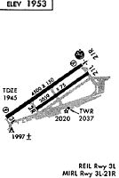
SFF Airport Runway Details
| Waterway 03W/21W | 6000 ft x 100 ft (1829 m x 30 m) | |
| Surface: | Water - No special surface treatment | |
Waterway 03W |
Runway 21W |
|
Glide Path Angle: |
0.0 degrees | 0.0 degrees |
Traffic Pattern: |
Right |
| Waterway 04L/22R | 4499 ft x 140 ft (1371 m x 43 m) | |
| Runway Length Source: | 3RD PARTY SURVEY as of 10/24/2017 | |
| Surface: | Water - No special surface treatment | |
| Runway Edge Lights: | Medium Intensity | |
Runway Weight Bearing Capacity (in thousands of pounds) |
||
| Single Wheel Landing Gear: | 30.0 | |
Waterway 04L |
Runway 22R |
|
Elevation: |
1946.4 | 1956.7 |
Latitude: |
47-40-45.1211N | 47-41-11.0982N |
Longitude: |
117-19-52.9933W | 117-18-59.6764W |
|
Runway True Alignment: |
054 | 234 |
ILS Type: |
ILS/DME | |
Glide Path Angle: |
3.0 degrees | 3.5 degrees |
Traffic Pattern: |
Left | Right |
Runway Markings Type: |
Nonprecision Instrument | Precision Instrument |
Runway Markings Condition: |
Good | Good |
Object at End: |
TREE | |
Object Height: |
72 | |
Distance from End: |
2045 | |
Visual Glide Slope Indicators: |
2-Box VASI On Left Side Of Runway | 2-Box VASI On Right Side Of Runway |
Approach Light System: |
1,400 Foot Medium Intensity Approach Lighting System With Runway Alignment Indicator Lights | |
REIL: |
Yes | No |
Threshold Crossing Height: |
50 | 44 |
Declared Distances |
||
Take Off Run Avbl. (TORA): |
4499 | 4499 |
Take Off Distance Avbl. (TODA): |
4499 | 4499 |
Actual Stop Dist. Avbl. (ASDA): |
4499 | 4499 |
Landing Dist. Avbl. (LDA): |
4499 | 4499 |
| Waterway 04R/22L | 2650 ft x 75 ft (808 m x 23 m) | |
| Runway Length Source: | 3RD PARTY SURVEY as of 10/24/2017 | |
| Surface: | Water - No special surface treatment | |
Runway Weight Bearing Capacity (in thousands of pounds) |
||
| Single Wheel Landing Gear: | 30.0 | |
Waterway 04R |
Runway 22L |
|
Elevation: |
1950.3 | 1953.7 |
Latitude: |
47-40-51.7448N | 47-41-07.0413N |
Longitude: |
117-19-26.9291W | 117-18-55.5167W |
|
Runway True Alignment: |
054 | 234 |
Glide Path Angle: |
0.0 degrees | 3.8 degrees |
Traffic Pattern: |
Right | Left |
Runway Markings Type: |
Basic | Basic |
Runway Markings Condition: |
Good | Good |
Object at End: |
TREE | |
Object Height: |
91 | |
Distance from End: |
1855 | |
Visual Glide Slope Indicators: |
4-Light PAPI On Left Side Of Runway | |
Threshold Crossing Height: |
39 | |
Declared Distances |
||
Take Off Run Avbl. (TORA): |
2650 | 2650 |
Take Off Distance Avbl. (TODA): |
2650 | 2650 |
Actual Stop Dist. Avbl. (ASDA): |
2650 | 2650 |
Landing Dist. Avbl. (LDA): |
2650 | 2650 |
Services
Airframe Repair: |
None |
Powerplant Repair: |
None |
Bottled Oxygen: |
None |
Bulk Oxygen: |
None |
Fuel Available: |
100LL |
Landing Fees: |
No |
Parking: |
Tiedowns available |
Maps & Diagrams

SFF Sectional
Flight Planning
at skyvector.com
at skyvector.com